
Hill Slopes
Let’s imagine you are standing on a hilltop, looking down at the valley below. The land between where you stand and the valley floor isn’t flat—it slopes downward at various angles. This angular inclination of terrain between hilltops and valley bottoms is what we call a slope. But why does this happen? What shapes these slopes? Why do some slopes look gentle, while others are steep and rugged? Let’s understand the science behind it.
Formation of Slopes
Slopes do not form randomly; they are shaped by a mix of natural forces and geological factors, like:
✔ Geological Structure: The type of rocks and their arrangement influence the steepness and stability of slopes.
✔ Climate: Heavy rainfall speeds up erosion, while arid climates preserve steep slopes.
✔ Vegetation Cover: Dense vegetation slows down erosion, while barren lands are more vulnerable.
✔ Relative Relief: The difference between the highest and lowest points in an area affects slope formation.
✔ Denudational Processes: Forces like weathering (breaking of rocks), erosion (removal of material), mass movements (landslides), and deposition (settling of materials) constantly modify slopes.
Why Study Slopes? The Role in Earth’s Dynamic System
Slopes are not just passive landforms; they are active participants in shaping landscapes. They influence:
🔹 The flow of rivers and formation of valleys.
🔹 Landslides and soil erosion risks.
🔹 Human settlements, agriculture, and infrastructure planning.
🔹 Climate and ecosystem interactions.
Simply put, without slopes, rivers wouldn’t flow, valleys wouldn’t exist, and our world would look drastically different.
Now, let’s define slopes as follows:
Slope is defined as an angular inclination of terrain between hill tops and valley bottoms resulting from the combinations of many positive factors like geological structure, climate, vegetation cover, relative reliefs and other denudational processes such as weathering, erosion, mass movements and deposition
The Two Phases of Slope Studies: From Observations to Calculations
1️⃣ Initial Phase: The Age of Observation
Early geomorphologists, much like ancient explorers, studied slopes through direct field observations. They described how slopes evolve based on their shapes and appearances. Two important models emerged:
✅ Davisian Model (Slope Decline): Proposed by William Morris Davis, it suggests that slopes start steep but gradually become gentler due to continuous erosion. Imagine a sharp mountain peak slowly eroding into rolling hills.
✅ Penckian Model (Slope Replacement): Introduced by Walter Penck, this model argues that instead of just declining, slopes get replaced by newer slopes due to ongoing tectonic uplift and erosion happening simultaneously. Think of a sand dune—while wind erodes one side, new sand accumulates on the other.
This phase relied on qualitative descriptions rather than precise measurements.
2️⃣ Modern Phase: The Era of Precision
With advances in technology, scientists moved from mere observations to quantitative analysis. This phase introduced:
📌 Topographical maps and aerial photographs to measure slopes accurately.
📌 Field measurements of slope angles for scientific analysis.
📌 Instruments to track slope movements and processes like landslides.
Researchers like R.A. Savigear and A. Young pioneered this approach, making slope studies more data-driven and predictive.
Conclusion
Slopes are not just inclinations of the land; they are dynamic landscapes that reveal the history of geological changes, climatic influences, and denudational processes. From the observational phase of Davis and Penck to the precision-driven studies of modern researchers, our understanding of slopes has evolved significantly.
Understanding the Different Elements of a Hillslope
If you observe a hill, it is a layered staircase rather than a simple slanting surface. Each part of this hillslope profile plays a distinct role in shaping the landscape. Let’s study its four major elements—each having unique characteristics and processes at work.
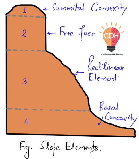
1️⃣ Summital Convexity: The Crest of the Hill
Think of the summital convexity as the rounded peak of a hill. This is the uppermost portion where:
✔ The surface curves outward, forming a convex shape.
✔ It is covered with weathered material (broken-down rock and soil).
✔ Soil creep (slow, downhill movement of soil) dominates transportation here, shifting material gradually over time.
This zone acts as the source region for material movement, feeding debris to the slopes below.
2️⃣ Free Face: The Steepest Drop
If the summital convexity is a gentle dome, the free face is like a vertical cliff. This element:
✔ Resembles a wall-like, precipitous slope made of bare rock.
✔ Is devoid of loose debris—any material falling from it quickly moves downward.
✔ Undergoes backwasting, meaning it erodes in a way that causes it to retreat parallel to itself over time.
Picture a fortress wall—over centuries, erosion chips away at it, but instead of crumbling from the top, the whole wall shifts backward.
3️⃣ Rectilinear Element: The Regular Slope
Moving downward, we reach the rectilinear element, the straight, uniform segment of the hillslope. It:
✔ Lies between the free face (above) and the concave slope (below).
✔ Has a constant slope angle, making it appear regular or uniform.
✔ Is often covered in rock debris, earning it the nickname debris slope.
This part of the slope serves as a transition zone, where material from above starts accumulating before moving further down.
4️⃣ Concave Element: The Gentle Base
At the lowest part of the hillslope, we find the concave element, which:
✔ Forms the basal segment of the slope profile.
✔ Has a gradually decreasing angle, meaning the slope becomes gentler as it extends downward.
✔ Is also called a waning slope, as the steepness diminishes progressively.
Imagine a river valley at the base of a hill—here, material finally settles, forming a stable depositional zone.
Conclusion
Each of these four slope elements plays a role in shaping hills over time. From the slow movement of soil at the summital convexity, the sheer drop of the free face, the steady debris flow of the rectilinear element, to the gradual flattening of the concave slope—hillslopes are dynamic landforms, constantly evolving under the forces of erosion and deposition.
Classification of Slopes: Understanding the Variability in Hillslope Profiles
While an ideal hillslope consists of all four elements—summital convexity, free face, rectilinear slope, and concave base—these elements don’t always appear together. Their presence and arrangement depend on local conditions, geological structure, and the stage of erosion.
For example:
✔ In areas with low relief, a free face may not develop at all.
✔ If hard and soft rocks alternate, there may be multiple free faces and rectilinear elements rather than a smooth transition.
✔ The dominance of slope elements changes over time—in the youthful stage, summital convexity is more prominent; in the mature stage, rectilinear slopes become dominant; and in the old stage, concave slopes take over.
Now, let’s explore how slopes are classified.
1️⃣ Genetic Classification of Slopes
This method classifies slopes based on how they were formed—whether due to tectonic movements, erosion, or deposition.
A. Tectonic Slopes: The Product of Earth’s Movements
These slopes arise due to tensional and compressional forces in the Earth’s crust, leading to the formation of fault scarps (steep slopes formed by faulting) and tilted rock beds.
✔ Example: Scarp slopes formed by faulting, like the Western Ghats escarpments.
B. Erosional Slopes: Sculpted by Natural Forces
These slopes are shaped by rivers, glaciers, and sea waves, which gradually wear down the landscape.
✔ River valleys evolve through different stages—youth, maturity, and old age—modifying slope profiles over time.
✔ Example: River-cut slopes in the Chambal ravines.
C. Slopes of Accumulation: Built by Deposits
These slopes form due to the deposition of sediments carried by rivers, wind, and glaciers.
✔ Such slopes are also called aggradational slopes.
✔ Example: Alluvial fans and cones created by rivers, sand dunes formed by wind action in deserts.
2️⃣ Quantitative Classification of Slopes
This method, proposed by A. Young, categorizes slopes based on their angle of inclination.
| Slope Category | Inclination (in degrees) | Example |
| Level or gentle slope | 0° – 2° | Flat plains, river deltas |
| Gentle slope | 2° – 5° | Rolling hills, agricultural fields |
| Moderate slope | 5° – 10° | Lower mountain foothills |
| Moderately steep slope | 10° – 18° | Hilly terrain, plateaus |
| Steep slope | 18° – 30° | Mountain slopes, cliff bases |
| Very steep slope | 30° – 45° | Rocky escarpments, canyon walls |
| Precipitous to vertical slope | 45° – 90° | Cliffs, vertical rock faces like the Himalayas |
Conclusion: Slopes are Dynamic and Diverse
Understanding slope classification helps in geological studies, construction planning, and environmental management. Whether formed by tectonic activity, erosion, or deposition, slopes evolve over time, continuously reshaping the landscape.
Sample Question
Discuss the geomorphological differences between convex and concave slopes with suitable examples. Explain how these slope profiles evolve over time according to the models of slope development. (15 Marks)
Answer:
A slope is the inclined surface of the land which varies in shape, gradient, and material composition. Based on their profile, slopes are classified into convex and concave types. Understanding slope evolution is crucial in geomorphology as it explains the transformation of landscapes over time.
Convex Slopes:
- Convex slopes have a bulging outward shape with a steep gradient at the top and a gentle slope downward. These slopes are formed due to rapid weathering and removal of material from the upper region.
- Example: The upper slopes of the Shivalik Hills. According to Davis’ Slope Decline Theory, convex slopes dominate in the youthful stage of landform development.
Concave Slopes:
- Concave slopes have a curved inward profile with a gentle gradient at the base. These slopes result from material deposition at the base due to continuous erosion from the upper slope.
- Example: Piedmont Plains of the Himalayas. Davis’ model suggests that concave slopes develop in the old stage of landscape evolution due to slope decline.
Slope Evolution Models:
- Davis’ Slope Decline Model: Slope angle progressively declines from convex to concave due to weathering and denudation.
- Penck’s Slope Replacement Model: Steep slopes are replaced by gentler ones through the accumulation of scree at the base.
- King’s Parallel Retreat Model: Slopes retreat parallel without significant change in angle, resulting in the formation of pediments.
- Wood’s Model: Emphasized the backwasting of free face, resulting in rectilinear slopes followed by concave slopes.
Understanding slope development helps in land use planning, agriculture, and infrastructure development, especially in hilly regions vulnerable to landslides and erosion.
Approaches to the Study of Slope Development
To understand how slopes evolve and change over time, researchers use two major approaches: Slope Evolution Approach and Process-Form Approach. Each has its own methodology, advantages, and challenges.
1️⃣ Slope Evolution Approach: Tracing the Historical Development
This approach focuses on the historical transformation of slopes over time.
✔ Davisian Model of Slope Decline falls under this approach, which suggests that slopes undergo a gradual reduction in steepness over geological time.
Challenges of this Approach:
❌ Determining the original slope form is difficult due to the lack of physical evidence. Much of the study is based on speculations and deductions.
❌ Dating the slope formation is another major issue since slopes evolve over thousands to millions of years, and precise dating methods are often unavailable.
2️⃣ Process-Form Approach: Studying Present-Day Slope Morphology
✔ This approach examines the existing shape (form) of a slope at a given time and relates it to active geomorphic processes such as weathering, erosion, and mass wasting.
✔ It is based on the idea that slope types are directly related to slope forms and that denudation (wearing away of land) plays a crucial role.
✔ The rate and intensity of slope processes depend on rock type, climate, vegetation, relief, and structure.
Challenges of this Approach:
❌ Slow rate of slope processes make it difficult to measure and record changes over short periods.
❌ Isolating slope-forming processes is complex because not all geomorphic processes contribute to slope development.
❌ Climatic variations and slope forms do not always have a direct one-to-one relationship, making it harder to generalize slope development across different environments.
Conclusion: Complementary Approaches for Slope Study
Both approaches offer valuable insights—while Slope Evolution helps understand long-term slope changes, the Process-Form Approach helps analyze current slope behavior. However, due to the challenges in each approach, modern geomorphologists often use a combination of both methods to get a clearer picture of slope development and transformation.