
Introduction to Drainage System and Drainage Pattern
Suppose you are standing at the top of a hill after a heavy rainfall. As the rainwater falls, it begins to flow down through different small paths, merging with other water streams until it finally reaches a large river or lake. This entire process — where water finds its way through various channels and collects into a single water body — is essentially what we call a Drainage System.
But have you ever wondered why some rivers look like a tree with branches, some flow straight, and some seem to radiate from a central point like the spokes of a wheel? This specific arrangement of river channels over a geographical area is known as the Drainage Pattern. The pattern is shaped by the nature of the land (like mountains, valleys, and plains), the type of rocks, the geological history, and climatic conditions of that region.
Drainage System
The Drainage System refers to the origin, evolution, and development of streams or rivers over time. It explains how a river system forms from its source, how it carves its path, and eventually where it meets a large water body like a sea, lake, or ocean.
The formation of a drainage system largely depends on:
- Topography – The physical features of the land like mountains, valleys, plateaus, etc.
- Rock type – Hard rocks and soft rocks influence how easily a river can carve its path.
- Geological Structure – The underground structure of rocks and faults can shape the river’s course.
- Climatic Conditions – Regions receiving heavy rainfall may have well-developed drainage systems, whereas arid regions may have scattered water paths.
- Denudational History – The process of weathering, erosion, and deposition over time also influences the river’s flow.
Drainage Pattern
The Drainage Pattern refers to the spatial arrangement of rivers and streams in a specific geometrical shape based on the topography and rock structure of an area. The type of drainage pattern can reveal a lot about the geographical and geological characteristics of that region.
For example, if you look at the Himalayan rivers, they often resemble the branches of a tree — this is a Dendritic Pattern. In volcanic areas, rivers radiate outward from a central point like the spokes of a wheel — this is a Radial Pattern. Each pattern tells a unique story about the landscape.
Important Terminologies in Drainage System
1. Drainage Basin (River Basin or Catchment Area)
Imagine you are pouring water on a large table. The water will naturally flow toward the lowest point, collecting in one place. The area of the table that collects all the water is equivalent to a Drainage Basin.
A Drainage Basin is the entire area of land that collects rainwater and channels it into a single river or water body. The land acts like a funnel, collecting water from rainfall, melting snow, or underground sources and channelling it toward a common outlet (river, lake, or sea).
- River and Stream:
- River – A permanent flow of water that usually flows within a well-defined valley. Example: Ganga River.
- Stream – A temporary or seasonal flow of water, often without a permanent valley. Example: Rainwater streams during monsoon.
- Open Drainage Basin: When a river flows and eventually meets a sea or ocean, it is called an Open Drainage Basin.
- Example: Ganga River draining into the Bay of Bengal.
- Closed Drainage Basin (Endorheic Basin): When water flows into a low-lying area (like a lake) and has no external outlet to the sea, it is a Closed Drainage Basin.
- Example: Lake Chad in Africa, Aral Sea in Kazakhstan-Uzbekistan, Dead Sea between Israel and Jordan.
2. Drainage Divide (Water Divide)
A Drainage Divide is like a boundary that separates two adjacent drainage basins. It is usually a high point, like a ridge, mountain, or elevated plateau, from where water flows in opposite directions.
💡 Example:
- In the Himalayas, the water flowing on the southern side (towards India) drains into the Ganga River Basin, while the water on the northern side (towards Tibet) drains into the Brahmaputra River Basin.
- In the Western Ghats, the water flowing west drains into the Arabian Sea, while the water flowing east drains into the Bay of Bengal.
The Drainage Divide is highly noticeable in hilly regions but less prominent in flat plains like the Ganga Plains.
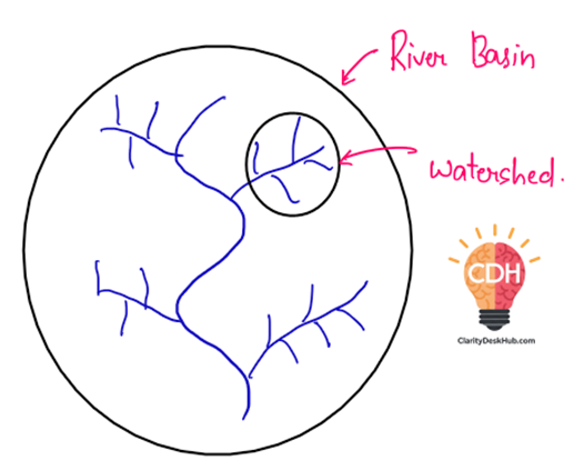
3. Difference Between River Basin and Watershed
A River Basin and a Watershed are similar in concept but differ in size.
| Aspect | River Basin | Watershed |
|---|---|---|
| Size | Large area covering major rivers and tributaries. | Small area covering small streams or lakes. |
| Water Body | Drains into large rivers. | Drains into small streams, lakes, or wetlands. |
| Example | Ganga River Basin (collects water from Yamuna, Chambal, Gandak, etc.). | A small stream flowing into the Yamuna. |
✅ Summary:
- The Drainage System explains how rivers originate, flow, and merge with large water bodies over time.
- The Drainage Pattern describes the geometrical shape formed by rivers based on the landscape and rock structure.
- The Drainage Basin is like a funnel collecting water, while the Drainage Divide acts as a natural boundary between two basins.
- A River Basin is large and drains into major rivers, while a Watershed is smaller and drains into small streams or lakes.