
Continental Drift Theory

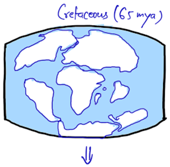
Let’s go back millions of years ago, to a time when the world as we know it didn’t exist. No seven continents. No Himalayas, Alps, or Andes. Just two massive landmasses—Laurasia in the north and Gondwanaland in the south—sitting near the poles like two giant puzzle pieces on a globe in the cretaceous period.
Now, you might ask—what caused these landmasses to move? This is exactly what F.B. Taylor tried to explain in 1910—much before Alfred Wegener’s more famous Continental Drift Theory (1912).
🌍 The Core Idea of Taylor’s Theory
According to Taylor:
- The continents moved horizontally, shifting towards the equator and westward over time.
- The force behind this movement? He believed it was the tidal force of the Moon—the same force that causes ocean tides but on a much grander scale.
🌊 The Moon’s Role – A Tug of War
To understand this, imagine a child pulling a blanket towards them. The fabric stretches, wrinkles, and shifts.
- Taylor suggested that the Moon’s gravity pulled the continents like this blanket, dragging them toward the equator and westward at the same time.
- This created tensional forces (pulling forces), which caused land to split, rupture, and stretch apart.
📍 Major Changes That Happened
1️⃣ Laurasia Moves from the North Pole
- As Laurasia moved southward, the land cracked and new water bodies formed.
- This led to the creation of Baffin Bay, Labrador Sea, and Davis Strait—all found near modern-day Canada and Greenland.
2️⃣ Gondwanaland Moves from the South Pole
- A similar process happened in the south.
- As Gondwanaland moved toward the equator, the Great Australian Bight and Ross Sea were formed.
3️⃣ Formation of Oceans
- The Arctic Ocean was created between Greenland and Siberia as Laurasia drifted away.
- The Atlantic Ocean and Indian Ocean were thought to be formed as depressions filled with water due to these massive movements.
4️⃣ How Did Mountains Form?
Taylor believed that when continents moved, their leading edges crumpled and folded, just like how a carpet bunches up when you push it forward.
- Himalayas, Caucasus, and Alps → Formed as Laurasia and Gondwanaland moved toward the equator.
- Rockies and Andes → Formed due to westward movement of landmasses.
🤔 The Criticism – Why Taylor’s Theory Was Flawed
Taylor’s theory had some big issues, which made scientists question its validity.
1️⃣ Displacement Issue: He proposed that continents moved thousands of kilometers, whereas modern research shows that only a few dozen kilometers of displacement is enough to create mountains.
2️⃣ Tidal Force Problem: If the Moon’s gravity was strong enough to move continents thousands of kilometers, it would have also stopped Earth’s rotation, which clearly didn’t happen.
3️⃣ Lack of Evidence: Taylor didn’t provide a clear mechanism for how the Moon’s pull could move such massive landmasses.
📌 Final Thought – Why Is This Important?
Although Taylor’s theory was not widely accepted, it was one of the first serious attempts to explain continental movement. It paved the way for Alfred Wegener’s Continental Drift Theory (1912) and eventually led to the modern Plate Tectonics Theory.
Continental Drift Theory of Wegner
🌍 Let’s again travel Millions of Years Back!
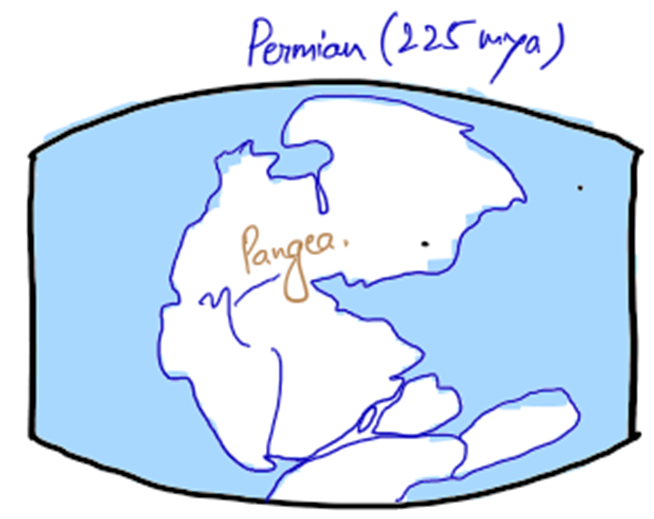
Imagine you are in a time machine that takes you back 300 million years. The Earth looks nothing like today—there are no seven continents, no separate Atlantic or Indian Ocean. Instead, there’s just one gigantic landmass called Pangaea, surrounded by a single vast ocean—Panthalassa.
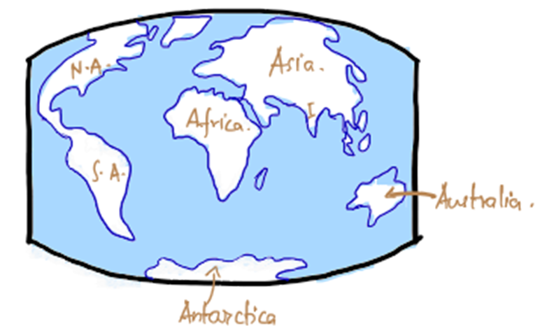
Now, let’s fast forward. Over millions of years, this giant landmass cracks, splits, and drifts apart, forming the modern continents we see today. This is the essence of Wegener’s Continental Drift Theory, proposed in 1912.
But why did Wegener propose this idea? Let’s break it down step by step.
🧐 The Problem Wegener Wanted to Solve
Wegener was not a geologist—he was a meteorologist (climate scientist). He was puzzled by the strange climatic changes recorded in Earth’s history.
- Why do we find fossils of tropical plants in Antarctica? 🌴❄️
- Why do we find evidence of glaciers in Africa, which is hot today? 🏜️❄️
He believed that climatic zones are permanent, but the continents move, which explains these past climate changes.
🧩 How Wegener Explained Continental Drift?
📍 Step 1: The Earth’s Layers (SIAL, SIMA, and NIFE)
Wegener followed the idea of Edward Suess, who suggested that Earth has three layers:
1️⃣ SIAL (Silica + Aluminum) → The upper layer, which forms the continents
2️⃣ SIMA (Silica + Magnesium) → The lower layer, forming the ocean floor
3️⃣ NIFE (Nickel + Iron) → The core of the Earth
He suggested that SIAL (continents) “floated” on the denser SIMA (ocean floor), like icebergs floating on water.
📍 Step 2: Pangaea Breaks Apart
According to Wegener:
- In the Carboniferous period (~300 million years ago), all continents were joined together in a supercontinent called Pangaea.
- About 200 million years ago, Pangaea split into two parts:
- Laurasia (North America, Europe, Asia) in the north
- Gondwanaland (South America, Africa, India, Australia, Antarctica) in the south
- Over millions of years, these landmasses continued breaking apart and drifting to form the continents we see today.

🌊 Forces Behind Continental Drift
Wegener proposed two main forces that moved the continents:
1️⃣ Equatorward Movement → Driven by:
- Gravity
- Pole-fleeing force (Centrifugal force)—Earth is not a perfect sphere; it bulges at the equator, creating a force that pushes landmasses away from the poles.
2️⃣ Westward Movement → Driven by:
- Tidal Forces caused by the Moon and the Sun
- Since Earth rotates west to east, these tidal currents push continents east to west.
⚠️ Problem: Modern physics proved that these forces were too weak to move continents, but at that time, this was a revolutionary idea!
🧾 Evidences Supporting Continental Drift
Wegener backed his theory with several scientific evidences:
🧩 1. Jig-Saw Fit (Puzzle Fit of Continents)
- If you look at a world map, South America and Africa seem to fit together like a jigsaw puzzle; Gold mines of Ghana coast and Brazil Matches.
- Brazil’s bulge fits into the Gulf of Guinea in Africa.
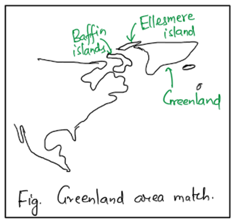
- Greenland fits with Ellesmere and Baffin Island (Canada).
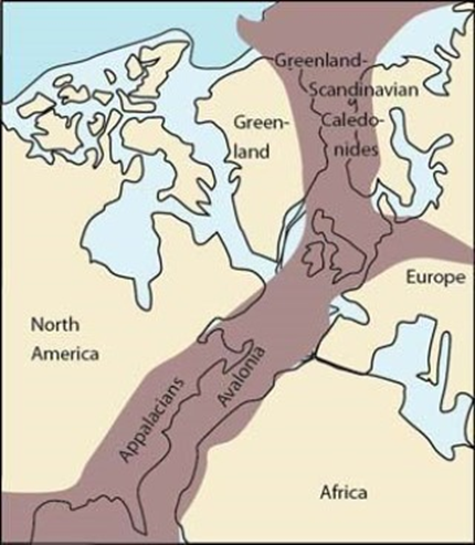
- The Caledonian and Hercynian mountains of Europe and the Appalachians of USA seems to be one continuous series.
- coal deposits of Appalachian Ellesmere Kjolen and Pyrenees match(see fig.)
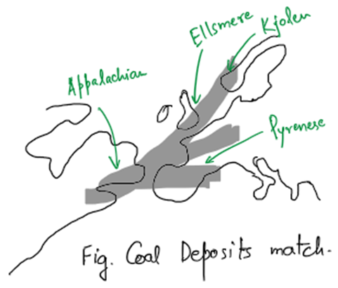
Appalacians and Caledonian mountains
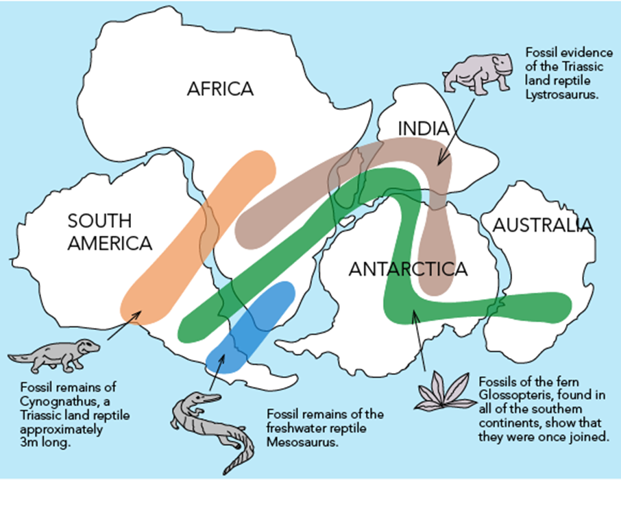
🦴 2. Fossil Evidence
Wegener found identical fossils of plants and animals on continents that are now separated by vast oceans. How is that possible?
- Mesosaurus (a freshwater reptile) was found in both Africa and South America. 🌊🐊
- It couldn’t have swum across the Atlantic Ocean, so the continents must have been connected once.
- Glossopteris (a fern plant) fossils were found in India, Antarctica, Africa, Australia and South America. 🌿
- This suggests they all shared the same climate and landmass in the past.
🗻 3. Matching Mountain Belts & Rock Formations
- When continents are reassembled as Pangaea, mountain ranges align perfectly:
- Appalachians (USA) match with mountains in Scotland and Norway.
- West African mountains match with those in Brazil.
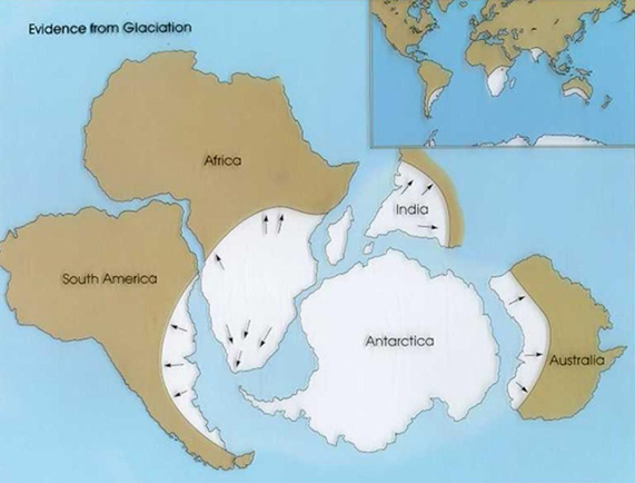
❄️ 4. Paleoclimatic Evidence (Past Climates)
- Evidence of glacial deposits (scratches left by glaciers) was found in India, Africa, South America, and Australia—places that are hot today!
- This suggests that these continents were once close to the South Pole before drifting away.
🔍 Scientific Evidence That Continents Are Still Moving
1️⃣ Greenland is drifting westward at 20 cm per year.
2️⃣ The Sea-Floor Spreading Theory (1960s) confirmed that the ocean floor is spreading, pushing continents apart.
3️⃣ The Mid-Atlantic Ridge shows that new oceanic crust is being formed, pushing Europe & North America apart.
🤔 Criticism – Why Was Wegener’s Theory Rejected?
Though Wegener gave strong evidences, his theory had big problems:
1️⃣ Forces were not strong enough:
- The tidal force required to move continents should have been 10,000 million times stronger! If such forces existed, Earth’s rotation would have stopped long ago!
- Similarly force of buoyancy and gravitational differential force are not enough to cause equatorward movement of the continents , instead the force, if so enormous, might have caused the concentration of the continents near the equator
2️⃣ Continents cannot “float” over ocean floors:
- Wegener thought SIAL floated on SIMA, but later studies showed entire lithosphere (both continents & ocean floor) floats over a semi-molten layer (Asthenosphere).
3️⃣ Contradictions:
- He said SIAL drifts over SIMA without resistance, but also said SIAL scrapes the ocean floor to form mountains—self-contradictory!
- He could not explain how Himalayas (in the middle of a continent) were formed.
4️⃣ Island Formation:
- With respect to origin of island arcs he said that it is because of differential rate of continental drift & said that most of the islands are located on S-E side of large continents.
- According to him eastern margin of continent while moving could not keep pace with western margin. Thus eastern edge broke off to form islands.
- But it was later found that islands like Indonesia, Philippines etc. are volcanic in origin and were never been part of the continents.
5️⃣ Fossil Doubts:
- Some scientists argued that similar fossils could have evolved independently in different locations (parallel evolution).
6️⃣ Atlantic Ocean Refitting
- Both the coasts of Atlantic Ocean can’t be completely refitted.
7️⃣ Displacement of Continents
- Wegener did not elaborate the direction and chronological sequence of the displacement of the continents. He also did not describe the situations of pre-carboniferous times.
💡 Final Thought – Wegener’s Theory Opened the Doors to Plate Tectonics
Even though Wegener’s theory had flaws, it changed the way we understand Earth.
Later, in the 1960s, the Theory of Plate Tectonics finally gave a scientific explanation for continental drift—by proving that the Earth’s lithosphere is broken into plates that move over the asthenosphere.
References
- Kearey, Philip, et al. Global Tectonics. 3rd ed., Wiley-Blackwell, 2009.
- Condie, Kent C. Plate Tectonics & Crustal Evolution. 4th ed., Butterworth-Heinemann, 1997.
- Stanley, Steven M. Earth System History. 4th ed., W.H. Freeman, 2014.
- Frisch, Wolfgang, et al. Plate Tectonics: Continental Drift and Mountain Building. Springer, 2011.
- Wegener, Alfred. The Origin of Continents and Oceans. Translated by John Biram, Courier Corporation, 1966.
- Hess, Harry H. “History of Ocean Basins.” Petrologic Studies: A Volume in Honor of A. F. Buddington, Geological Society of America, 1962, pp. 599-620.
- Holmes, Arthur. Principles of Physical Geology. 2nd ed., Ronald Press, 1965.
- Tarbuck, Edward J., et al. Earth Science. 15th ed., Pearson, 2019.
- National Aeronautics and Space Administration (NASA). “Plate Tectonics and Continental Drift.” Earth Observatory, 2021, https://earthobservatory.nasa.gov.
- United States Geological Survey (USGS). “What is Plate Tectonics?” USGS, 2023, https://www.usgs.gov.


One Comment