Hypsometric and Mathematical Analysis
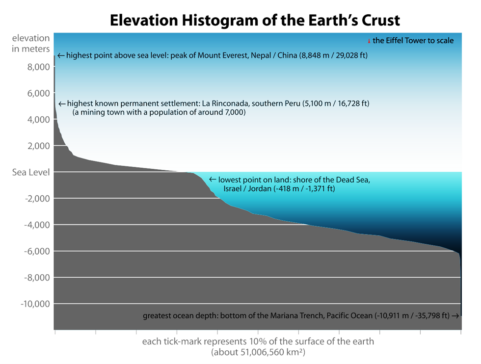
Imagine standing on the peak of Mount Everest, looking down at the vast land below. Now, picture yourself at the bottom of the Mariana Trench, the deepest part of the ocean. These two measurements—height above sea level and depth below sea level—are fundamental in understanding Earth’s surface. This is where hypsometry and bathymetry come into play.
Hypsometry vs. Bathymetry: The Two Sides of Elevation
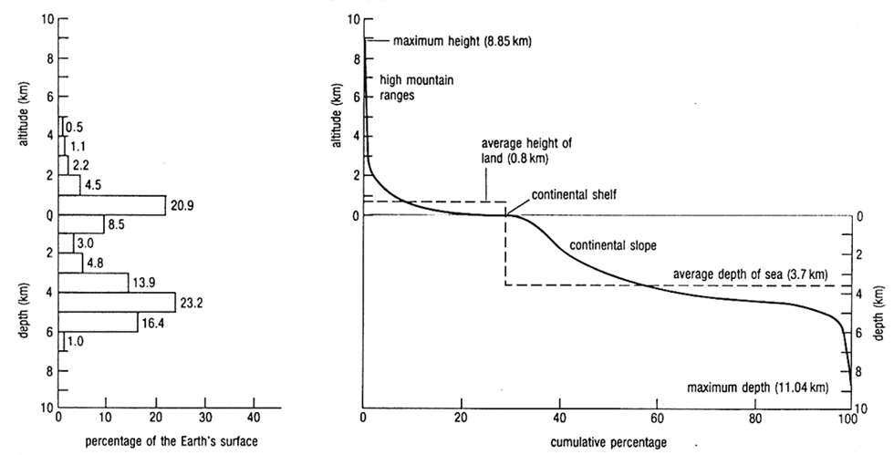
- Hypsometry deals with the measurement of Earth’s elevation above sea level, helping us understand mountains, plateaus, and plains.
- Bathymetry, on the other hand, measures depths below sea level, helping us map ocean basins, trenches, and ridges.
- Simply put, hypsometry denotes positive relief (land above sea level), while bathymetry denotes negative relief (underwater features).
Techniques for Measuring Ocean Depths
Over time, scientists have developed several methods to measure the depth of oceans:
1. Stone and String Method (Oldest Technique)
- A heavy rock tied to a long rope was dropped into the ocean.
- Once it hit the seabed, the length of the string was measured to estimate depth.
- Though rudimentary, this was the earliest method of bathymetry.
2. Acoustic Echo Sounders (Modern Standard Method)
- Ships send a sound pulse (10-30 kHz) towards the seafloor.
- The pulse reflects back as an echo, and the time taken for the echo to return is measured.
- Since the speed of sound in seawater is known, scientists calculate the depth using: Depth = (Velocity of Sound × Time)/2
- The first trans-Atlantic echo sounding was conducted by the US Navy Destroyer Steward in 1922.
- Since then, oceanographic and naval ships continuously use echo sounders for mapping the ocean floor.
3. Satellite Altimeters (Advanced Technology)
- Satellites profile the shape of the sea surface, which closely resembles the seafloor topography.
- Variations in sea level indicate underwater mountains, trenches, and ridges.
- This method allows global mapping of ocean depth with high precision.
Mathematical Advancements in Bathymetry
By the 1950s, the development of the Precision Depth Recorder (PDR) made depth calculations more accurate.
- Today, multibeam echo sounders and side-scan sonars provide high-resolution images of the ocean floor.
- These advancements have revolutionized oceanographic research, helping scientists discover new trenches, ridges, and seamounts.
Final Thoughts
From dropping stones into the ocean to using satellites and sonar, bathymetry has come a long way. Modern techniques allow us to visualize the ocean floor as accurately as we map land. This knowledge is crucial for marine navigation, underwater construction, and understanding tectonic activity beneath the oceans.