
Introduction to Geomorphology
Let’s begin with the definition.
Just split the word:
Geo = Earth, Morpho = Form, Logy = Study
So, Geomorphology means “the study of Earth’s forms” — more precisely, it is the scientific study of landforms — the physical features you see on the Earth’s surface like mountains, valleys, plateaus, plains, etc.
But it doesn’t stop at just looking at them. It also describes, interprets, and analyzes how these features formed, how they evolved, and what forces shaped them. That’s the essence of geomorphology.
📌 Scope of Geomorphology
Now let’s understand how vast the subject is. The scope is typically structured in three broad aspects:
1️⃣ Dimensions and Scales of Relief Features
Just like any map has scales (1:50,000, 1:250,000 etc.), landforms are also studied based on their size and hierarchy. So we divide them into three orders:
🥇 First Order Relief Features 🌍
These are the biggest landforms on Earth:
- Continents (Asia, Africa…)
- Ocean Basins (Atlantic, Pacific…)
They are formed due to very large-scale tectonic activities, and studying them helps us understand continental drift, plate tectonics, and the general structure of the Earth’s crust.
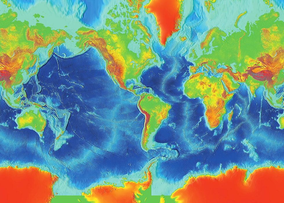
🥈 Second Order Relief Features – The Builders 🏔️
These are structural landforms found within continents:
- Mountains, Plateaus, Rift Valleys, Lakes, Fault lines
👉 These are mostly formed due to endogenetic forces (forces originating inside the Earth), specifically:
- Diastrophic Forces: Very slow but powerful — like mountain formation (orogeny), faulting, folding. So slow that they are not visible in a human lifetime.
- Catastrophic Forces: Sudden and violent — like volcanic eruptions, earthquakes.
Thus, second-order landforms are often called “constructional landforms” because they build new structures on the Earth’s surface.
🥉 Third Order Relief Features 🏞️
These are smaller features formed on second-order landforms, mainly due to exogenetic processes (forces acting from outside, like water, wind, ice).
These include:
- Erosional Landforms (formed when materials are removed):
Glacial valleys, river valleys, cirques, karst valleys - Depositional Landforms (formed when materials are deposited):
Drumlins, eskers, flood plains - Residual Landforms (left behind after erosion):
Monadnocks, inselbergs - Also, some minor tectonic features may appear here.
So, in a way, first order is the canvas, second order is the sketch, and third order is the detailing.
2️⃣ Processes That Shape the Landforms
Now the question arises: Who creates all this?
There are two main categories of forces:
🔥 Endogenetic Processes
These are internal forces rising from within the Earth — like the movement of magma, tectonic plate shifts, etc.
Examples:
- Folding and Faulting (Diastrophism)
- Volcanism
- Earthquakes
They are responsible for building landforms.
🌧️ Exogenetic Processes
These are external forces — those which wear down the landforms:
- Weathering (breaking down rocks)
- Erosion and Transportation (by rivers, wind, glaciers)
- Deposition (laying down materials elsewhere)
So, if endogenetic forces are like architects, exogenetic forces are like sculptors.
3️⃣ Approaches to Geomorphic Studies
To study all this, geographers use two key approaches:
🕰️ Historical Approach
Focuses on how landforms evolved over time — like tracing their biography from formation till now.
It answers:
“How did the Himalayas form?”,
“What was the Deccan Plateau like 100 million years ago?”
⚙️ Functional Approach
This is more practical and time-independent — it focuses on how landforms behave under current environmental factors.
For example:
- Why do certain rivers meander?
- How does rainfall affect soil erosion in a region?
Both these approaches are important. Historical helps us understand the past, while functional helps us manage the present and plan for the future, especially in land-use planning, disaster management, and environmental conservation.