
Water Eroded Arid Landforms
Suppose you’re standing in a vast, arid desert. The land appears dry and lifeless most of the year, but occasionally, a sudden torrential downpour occurs. Water gushes through the barren landscape, shaping it in unique ways. Unlike humid regions where rivers continuously erode land, in arid regions, water erosion happens sporadically but intensely, giving rise to distinctive landforms. Let’s understand them step-by-step.
1. Rill
Visualize this: It has just rained heavily in the desert, and water starts flowing down a barren hillside. Initially, it creates tiny, narrow channels on the surface, almost like hairline cracks on dry skin. These channels, formed by the direct impact of flowing water, are called rills.
- Definition: A rill is a narrow and shallow channel created on a slope by the erosive action of running water.
- Think of it like this: When you pour water on loose sand, you’ll notice small lines formed by water flow; that’s exactly how rills are formed.
However, rills are temporary. If it rains again and the water flow increases, these rills deepen and transform into something larger — gullies.
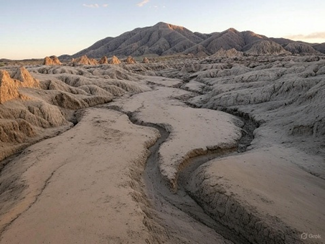
2. Gully
Now, imagine the rain continues to pour and the water flow gains strength. The small rills deepen and widen, creating ditches that resemble small valleys. These are known as gullies.
- Definition: A gully is a landform created by running water, resembling large ditches or small valleys.
- Depth: Gullies can range from a few meters to tens of meters in depth.
Gullies are the reason why farmlands in semi-arid regions become infertile, as the topsoil is completely washed away.
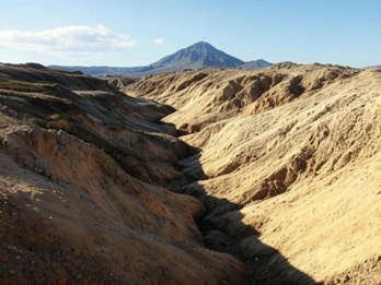
3. Ravine
If the process of erosion continues for years, the gullies become deeper and broader, eventually forming ravines. These ravines are commonly seen in Chambal Valley (Madhya Pradesh), where they have become a nightmare for agriculture.
- Definition: A ravine is a deep, narrow, and steep-sided landform created by continuous erosion from water streams.
- Scale: Ravines are larger than gullies but smaller than full-fledged valleys.
- Example: Chambal Ravines – notorious for their vast network of ravines formed by years of water erosion.
In summary:
- Rill → Gully → Ravine → (eventually) Valley if the process continues for centuries.
4. Badland Topography
When a region is dominated by excessive gully and ravine formation due to heavy erosion, the entire area turns into Badland topography. This land becomes unfit for agriculture or habitation, resembling a rugged, broken landscape.
- Definition: Badland Topography refers to a landscape with irregular, broken surfaces caused by extensive erosion through gullies and ravines.
- Example: Chambal Ravines – farmers struggle here because the land is severely eroded.
Why is it called ‘Badland’? Because the land is practically useless for agriculture and human settlement, hence termed ‘badland.’
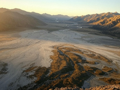
5. Bolsons
Now, let’s shift our attention to intermontane basins (flat regions between mountain ranges). In arid regions, such basins are called Bolsons. Whenever water flows down the mountains, it deposits sediments and forms unique landforms like pediments, bajadas, and playas.
- Definition: A Bolson is a closed, intermontane (between mountains) basin in arid regions where water collects temporarily after rainfall.
- Example: You can find bolsons in the arid regions of Thar Desert or Southwest USA.
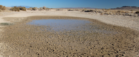
6. Playas
Imagine heavy rainfall in a desert. Water rushes down the slopes and collects in the lowest point of the bolson, forming a temporary lake. This lake is known as a Playa.
- Definition: A Playa is a temporary, shallow lake in an arid basin formed after heavy rainfall.
- What happens next? Since deserts have high temperatures, the water evaporates quickly, leaving behind salt deposits.
- When salt deposits accumulate: The playa turns into a Salina.
Example: The Rann of Kutch (Gujarat) during monsoon transforms into a shallow lake but dries up later, leaving salt deposits.
7. Pediments
As you move towards the mountain front, you’ll notice a broad, gently sloping rock surface at the base of the mountains. This is called a Pediment — the result of long-term erosion of the mountain front.
- Definition: A Pediment is a broad, gently sloping rock-cut surface found at the base of a mountain.
- Why does it form? Continuous erosion by water and wind gradually removes the debris from the mountain front, exposing the bedrock beneath.
- In form and function there is no difference between pediment, and alluvial fan. However, note that pediment is an erosional landform while fan is a constructional one.
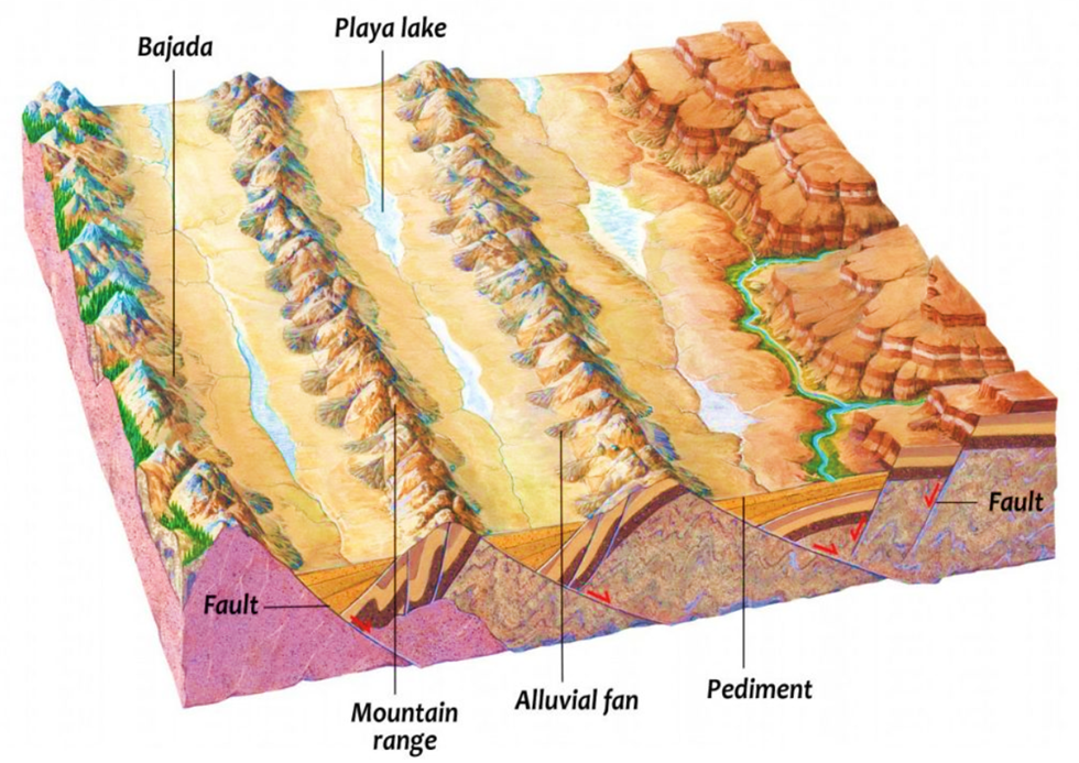
8. Bajada
As you move downslope from the mountain front, you notice large piles of sediments deposited by water. When several alluvial fans (fan-shaped deposits of sediments) merge together, they form a broader, gently sloping depositional plain called a Bajada.
- Definition: A Bajada is a broad, gently sloping plain formed by the merging of several alluvial fans.
- Function: Bajadas act as natural drainage zones for deserts.
✅ Summary of the Landscape
| Landform | Formed By | Key Feature |
| Rill | Surface water flow | Narrow, shallow channel |
| Gully | Continuous water erosion | Deep, small valley-like structure |
| Ravine | Large-scale water erosion | Deep, steep-sided landform |
| Badland | Extensive erosion | Broken, rugged, unusable land |
| Bolson | Water accumulation in basin | Large, enclosed dry basin |
| Playa | Temporary water lake | Salt flats after evaporation |
| Pediment | Mountain front erosion | Smooth, rock-cut surface |
| Bajada | Merging of alluvial fans | Gently sloping depositional plain |
💡 Why Is This Important?
Understanding these landforms helps us in:
- Soil conservation: Preventing further gully and ravine erosion can save agricultural land.
- Flood management: Recognizing playa basins can help manage water accumulation.
- Settlement planning: Avoiding badland areas for human settlement.
Thus, water in arid regions may be scarce, but when it comes — it reshapes the land like an artist sculpting on a canvas!
One Comment