
Drainage Patterns
A drainage pattern refers to the geometric arrangement of streams and rivers in a particular region, influenced by topography, geology, and structure of rocks. Different drainage patterns arise due to variations in slope, rock resistance, fault lines, and the geological history of the region.
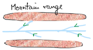
1. Trellis Drainage Pattern
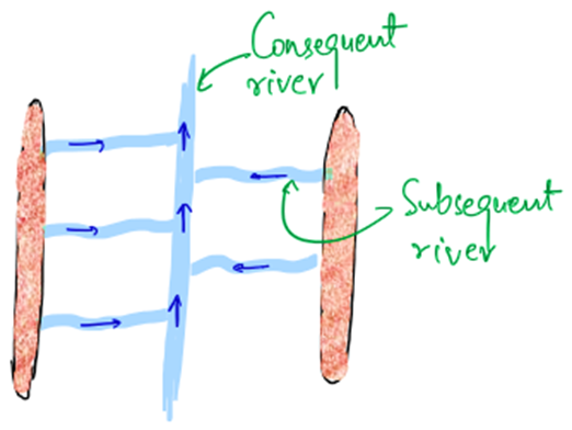
👉 Formation: This pattern is formed when tributaries flow parallel to each other and join the main river at right angles (90°).
👉 Conditions:
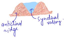
- Develops in folded mountain regions with alternating parallel anticlinal ridges and synclinal valleys.
- Ridges force the streams to flow down into valleys and then join the main river.
👉 Example:
- Drainage system in the Appalachian Mountains (USA).
- Parts of Aravalli Hills (India).
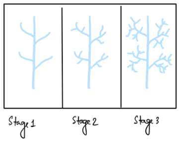
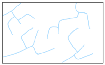
2. Dendritic Drainage Pattern
👉 Formation: The pattern resembles the branches of a tree where the main river acts as the trunk, and the tributaries appear like branches.
👉 Conditions:
- Formed in homogeneous or uniform rock structures with gentle slopes.
- Over time, open drainage patterns may become closed due to erosion
👉 Example:
- Ganga River System.
- Amazon River System.
3. Rectangular Drainage Pattern
👉 Formation: Similar to Trellis Drainage Pattern but the main difference is:
- Rectangular patterns are controlled by fault lines, fractures, or cracks in rocks instead of fold structures.
- Tributaries join the main river at approximately right angles
👉 Conditions:
- Develops in regions with fractured or faulted rocks.
- It is not influenced by anticlinal or synclinal structures but by rock weaknesses
👉 Example:
- Godavari River Basin (in Deccan Plateau).
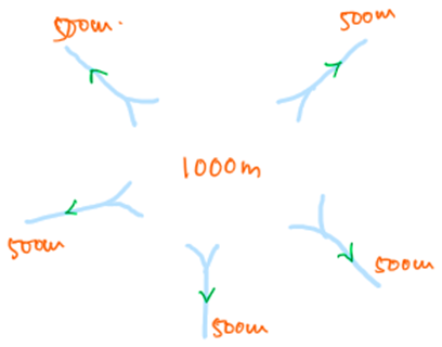
4. Radial Drainage Pattern (Centrifugal)
👉 Formation: Streams radiate outwards from a central elevated point, like a volcano or hill.
👉 Conditions:
- Formed around conical hills, domes, or volcanic mountains.
- Water flows in all directions away from the central high point.
👉 Example:
- Amarkantak Plateau (MP) – Origin of Narmada and Son Rivers.
- Mandav Hills (Gujarat).
- Sri Lanka’s entire drainage system.
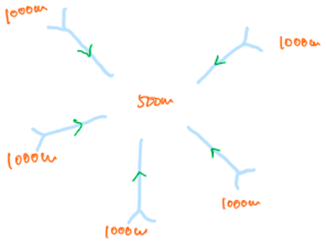
5. Centripetal Drainage Pattern (Opposite of Radial)
👉 Formation: Streams converge towards a central low-lying depression or basin instead of diverging.
👉 Conditions:
- Formed in basins, craters, or structural depressions.
- Water from different directions flows into a central point
👉 Example:
- Kathmandu Valley (Nepal).
- Inland Drainage Basins like the Sambhar Lake in Rajasthan.
6. Barbed Drainage Pattern (Result of River Capture)
👉 Formation: This pattern forms when:
- A tributary flows in the opposite direction to its master river after being captured by another river.
- This creates a sharp U or hook-shaped bend.
👉 Cause: River Capture (explained below).
👉 Example:
- Indus and its tributaries (Jhelum) show barbed patterns due to tectonic activity.
7. Pinnate Drainage Pattern (Feather-like)
👉 Formation:
- Streams flow in a narrow valley surrounded by steep slopes.
- Tributaries join the master river at acute angles (< 90°), giving a feather-like appearance.
👉 Example:
- Upper Son River Basin.
- Narmada River Basin in the Vindhya region.
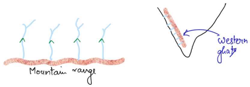
8. Parallel Drainage Pattern
👉 Formation: Numerous rivers flow almost parallel to each other in the same direction.
👉 Conditions:
- Formed in tilted or uniformly sloping rock strata or in mountain ranges (like cuestas).
- Found in regions of coastal plains or linear mountains.
👉 Example:
- Western Coastal Plains of India.
- Satpura and Vindhya Ranges in Central India.
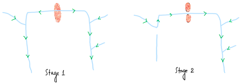
✅ River Capture (Stream Diversion or Stream Piracy)
👉 Definition:
- River Capture occurs when one river (Captor River) diverts the flow of another river (Capture River) through headward erosion or tectonic activity.
- This leads to the formation of a hook-shaped bend called an Elbow of Capture.
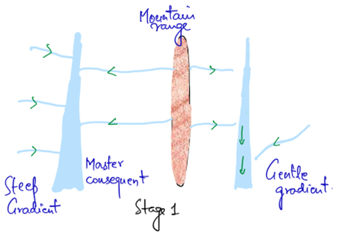
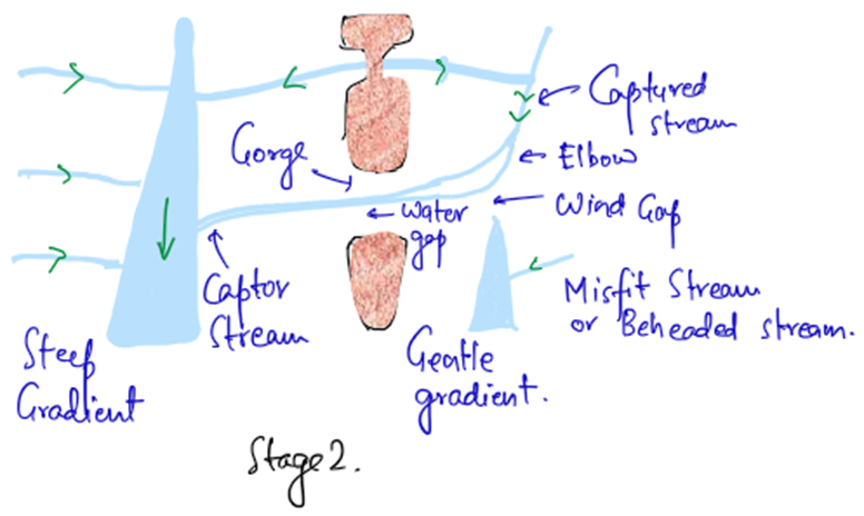
Key Components of River Capture:
| Feature | Explanation |
| Captor River | The river that captures another river. |
| Captured River | The river whose flow is diverted. |
| Elbow of Capture | The sharp hook-shaped bend where the capture occurs. |
| Misfit Stream | The remaining lower segment of the captured river, which now has less water and a smaller valley. |
| Wind Gap/Col | The dry or abandoned riverbed left behind after capture. |
✅ Major Causes of River Capture:
| Causes | Explanation |
| Steep Channel Gradient | A steep slope allows a river to erode faster and capture another river. |
| Narrow Valley | The narrower the valley, the higher the chance of capture. |
| Soft Rocks | Soft rocks are easier to erode, allowing faster headward erosion. |
| Deeper Valley | Rivers flowing in deep valleys tend to capture neighboring streams. |
| Headward Erosion | The upper portion of a river cuts back rapidly, capturing another stream. |
| Low Sediment Load | Rivers with less sediment load can erode faster. |
| Rejuvenation | Tectonic uplift may cause rejuvenation, allowing a river to cut deeper and capture. |
✅ Examples of River Capture in India:
- Yamuna captured Chambal River – This led to the creation of deep gorges in Chambal.
- Jhelum captured Tawi River in Kashmir.
- Godavari River captured the Manjira River in the Deccan Plateau.
✅ Quick Summary (Golden Points)
| Pattern Type | Flow Characteristic | Key Example |
| Trellis | Tributaries join the master river at right angles | Aravalli Hills |
| Dendritic | Resembles a tree-like branching structure | Ganga Basin |
| Rectangular | Guided by fault lines, fractures | Godavari Basin |
| Radial | Streams diverge from central high point | Amarkantak Plateau |
| Centripetal | Streams converge into a depression/basin | Kathmandu Valley |
| Barbed | Tributaries flow opposite to the master stream | Jhelum River |
| Pinnate | Tributaries join at acute angles (<90°) | Son and Narmada |
| Parallel | Several rivers flow parallel in the same direction | Western Ghats |
✅ Fun Trick to Remember Patterns:
| Pattern | Trick to Remember |
| Trellis | Folded mountains → Trellis (like a railway track) |
| Dendritic | Dendritic → Tree branches → Common in plains |
| Rectangular | Fault lines → Right angles → Geologically fractured areas |
| Radial | Volcano → Water flows in all directions |
| Centripetal | Basin → Water converges at a central point |
| Barbed | Hook-shaped bend → Opposite flow due to capture |
| Pinnate | Narrow valley → Acute angle tributaries |
| Parallel | Mountain ranges → Parallel rivers |
👉 Pro Tip: In UPSC or Geography exams, questions related to drainage patterns often test your understanding of landforms and geological structures. So always connect drainage patterns with their geomorphological setting (fold mountains, volcanic cones, fault lines, etc.).
Sample Question
Q. In the Davisian geomorphic cycle, upliftment is considered the initial stage of landform evolution. Explain the origin of rivers in this context and discuss how pre-existing and newly formed drainage systems respond to tectonic uplift. (250 words)
Answer:
Introduction
In the Davisian geomorphic cycle, landform evolution begins with tectonic uplift, followed by fluvial erosion. However, the presence of rivers before or after uplift raises an important question—where do these rivers come from? Rivers can be pre-existing (antecedent) or formed later (consequent) due to rainfall and surface runoff.
1. Origin of Rivers in the Context of Uplift
Rivers can originate in two ways:
- Pre-existing Rivers (Antecedent Rivers): These rivers exist before uplift and maintain their course by cutting through rising land.
- Example: Brahmaputra and Indus Rivers cut deep gorges through the Himalayas, proving their existence before the mountains formed.
- Newly Formed Rivers (Consequent Rivers): If no river exists initially, rainfall on the uplifted surface creates small streams that join to form larger rivers.
- Example: Rivers of the Deccan Plateau (e.g., Krishna, Godavari) developed after the plateau uplifted.
2. Response of Drainage Systems to Uplift
- Antecedent rivers maintain their path by downcutting into the uplifted terrain, forming deep gorges.
- Consequent rivers adjust to the slope created by uplift, flowing in new directions.
- Over time, both types contribute to youthful landforms, like V-shaped valleys, waterfalls, and rapids.
Conclusion
Rivers in the geomorphic cycle are either pre-existing and adjusted to uplift (antecedent) or formed due to surface runoff (consequent). Understanding these processes helps explain landform evolution in response to tectonic forces.
2 Comments