
Fluvial Erosional Landforms
Over centuries, rivers carve, shape, and transform the land — forming valleys, gorges, canyons, and many other landforms. These landforms created by the erosion of running water are collectively called erosional landforms.
River Valleys
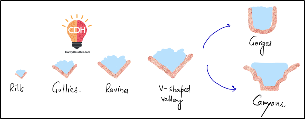
A valley is essentially a low-lying depression on the Earth’s surface carved by a river. It is considered a negative landform because material is eroded away rather than deposited. Interestingly, valleys don’t form instantly. It’s a slow and sequential process:
- Step 1: It starts with Rills — small, narrow channels formed by surface runoff.
- Step 2: Over time, rills become larger, turning into Gullies — deeper and wider cuts.
- Step 3: With continuous erosion, gullies develop into Ravines — deeper and narrower landforms.
- Step 4: Eventually, continuous erosion of ravines leads to the formation of Valleys.
Depending on their shape and formation, valleys are categorized into:
a. V-Shaped Valley
- Formed during the youth stage of a river when vertical erosion dominates.
- The rapid downward cutting forms a distinct V-shaped cross-section.
- Example: Ganges River in its upper course (Himalayas).
b. Gorge (Deep, Narrow Valley)
- Picture a deep narrow valley with steep vertical walls — that’s a gorge.
- Gorges are formed due to intense vertical erosion by rivers during their youthful stage.
- The width of a gorge is almost equal from top to bottom.
- Example: Indus Gorge in the Ladakh region.
c. Canyon (Steep, Step-like Valley)
- Similar to a gorge but wider at the top and narrower at the bottom, giving it a step-like appearance.
- Canyons form in regions with alternating hard and soft rock layers, causing differential erosion.
- Example: Grand Canyon in the USA.
Activities Involved in Valley Formation
A river sculpts a valley through three major processes:
a. Valley Deepening (Vertical Erosion)
- This process is most active in the youth stage of a river.
- The river cuts deep into its valley through vertical erosion, resulting in V-shaped valleys, gorges, and canyons.
- Factors influencing valley deepening:
- Volume and velocity of water.
- Type of rock (hard rocks resist erosion; soft rocks erode faster).
- Load carried by river (boulders, pebbles, etc.).
b. Valley Widening (Lateral Erosion)
- As the river matures, vertical erosion slows down, and lateral erosion (side-to-side cutting) increases.
- Processes involved:
- Undercutting of valley sides by hydraulic action and abrasion.
- Sheet wash erosion during floods.
- Development of meanders (curved loops in a river), further widening the valley.
- Result: Broad, flat-bottomed valleys.
c. Valley Lengthening (Headward and Seaward Erosion)
- Over time, a river increases its length both:
- Headward Erosion – The river erodes upstream, extending its source.
- Seaward Erosion – The river pushes its mouth further into the sea (especially when sea levels fall).
- Processes like river capture also contribute to valley lengthening.
- River Capture: When a stronger river diverts the flow of a weaker river into its own channel.
River Course
Just like humans have stages of life (childhood, adulthood, old age), rivers also pass through three stages in their journey from source to mouth.
Let’s explore each:
⛰️ Youthful Stage
- Found near the source in mountainous regions.
- River has steep gradient, high energy, and torrential speed.
- Main work: Headward erosion (cutting into its source).
- Forms:
- V-shaped valleys
- Waterfalls
- Rapids
Example:
- Himalayan Rivers in upper reaches: Bhagirathi near Gaumukh, Teesta near Zemu Glacier.
🌾 Mature Stage
- River now enters plains.
- Energy decreases, slope becomes gentler.
- Dominant process: Lateral erosion, creating meanders.
- River carries larger sediment load, and deposition begins on inner bends.
Example:
- Rivers in the Indo-Gangetic-Brahmaputra plain — like the Ganga at Patna, Yamuna near Delhi.
🌊 Old Age Stage
- Found near the river’s mouth, close to sea/lake.
- Velocity is very low, so deposition dominates.
- Features formed:
- Temporary islands (e.g., Majuli in Brahmaputra – world’s largest river island)
- Braided channels (river splits into many channels)
- Delta formation (river mouth keeps shifting forward)
Example:
- Ganga-Brahmaputra Delta, the largest delta in the world.
Potholes and Plunge Pools
Imagine a fast-flowing river carrying boulders and pebbles that continuously swirl around a fixed point in the riverbed. This rotational movement carves out circular depressions in the rocky bed, called:
a. Potholes
- Small, circular depressions formed on the rocky bed of a river due to:
- Abrasion by pebbles and stones.
- Continuous swirling of water.
- Potholes gradually enlarge to form plunge pools.
b. Plunge Pools
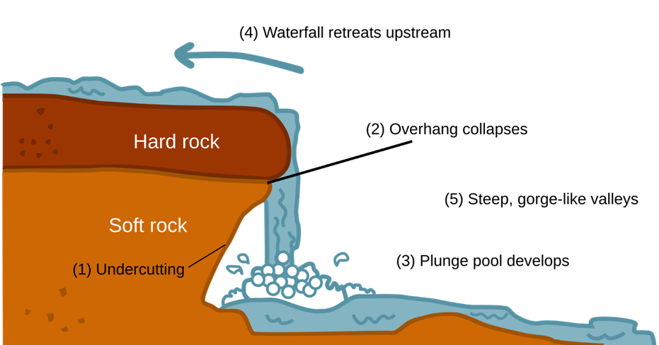
- When a river forms a waterfall, the force of falling water along with the swirling boulders creates a deep depression at the waterfall’s base.
- This deep depression is called a Plunge Pool.
- Example: Jog Falls (Karnataka) has a deep plunge pool.
Waterfalls
A waterfall is simply a sudden drop in a river’s course, where water falls vertically from a height. Waterfalls generally form due to:
Causes of Waterfalls:
- Unequal rock resistance — Hard rocks resist erosion, soft rocks erode quickly.
- Tectonic upliftment — Sudden changes in land elevation cause steep drops.
- Sea level fall — When sea level falls, rivers adjust their profile by creating waterfalls.
- Famous Examples:
- Angel Falls (Venezuela) – World’s highest waterfall.
- Jog Falls (India) – Deep plunge pool formation.
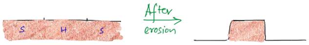
Structural Benches
- When a river flows over alternating hard and soft rock layers, the softer layers erode faster, leaving behind step-like benches called Structural Benches.
- They resemble giant staircases along the river.
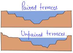
River Terraces
Imagine a river flowing through a valley over thousands of years. The valley floor changes over time due to erosion and deposition. The old valley floors, now elevated as the river cuts deeper, are called:
River Terraces
- Flat surfaces on either side of the river, representing former valley floors.
- They indicate the historical water levels of the river.
Types of River Terraces:
- Paired Terraces — Occur at the same height on both sides of the river, indicating uniform vertical erosion.
- Unpaired Terraces — Occur at different heights, indicating uneven lateral erosion or river shifting.
- Example: The Ganga Plains have several terraces formed by historical river flows.
✅ Why Is This Important?
Understanding fluvial erosional landforms is crucial because:
- It helps geologists understand how landscapes evolved over time.
- It assists civil engineers in designing bridges, dams, and river management projects.
- It provides insight into natural resource distribution (like fertile floodplains).
Sample Question
Q. Differentiate between River Terraces and Canyons in terms of their formation, geomorphological characteristics, and associated geological processes. Illustrate your answer with suitable examples from India and the world.
Answer:
Introduction
River valleys evolve through fluvial erosion, giving rise to distinct landforms like River Terraces and Canyons, shaped by varying erosion processes.
Difference between River Terraces and Canyons
| Aspect | River Terrace | Canyon |
| Formation Process | Formed by vertical erosion and base level changes, creating step-like terraces. | Formed by intense vertical erosion in uplifted areas, creating deep valleys. |
| Erosion Nature | Intermittent erosion leaves older floodplains as terraces. | Continuous vertical erosion deepens the valley. |
| Geomorphology | Step-like, parallel terraces along the valley. | Steep, narrow valleys with wider tops. |
| Base Level Influence | Changes in base level (sea level, tectonics) lead to terrace formation. | Rapid tectonic uplift accelerates vertical erosion. |
| Sediment Deposition | Contains old alluvial deposits. | Minimal sediment deposition. |
| Examples (India) | Alaknanda River (Uttarakhand), Gandak River (Bihar). | Indus Gorge (Ladakh), Gandikota Canyon (Andhra Pradesh). |
| Examples (World) | Colorado River terraces (USA). | Grand Canyon of Colorado (USA). |
Conclusion
River Terraces indicate past base level changes and depositional phases, while Canyons signify rapid vertical erosion in tectonically active zones. Studying these landforms helps in understanding Earth’s geomorphological history.
One Comment