
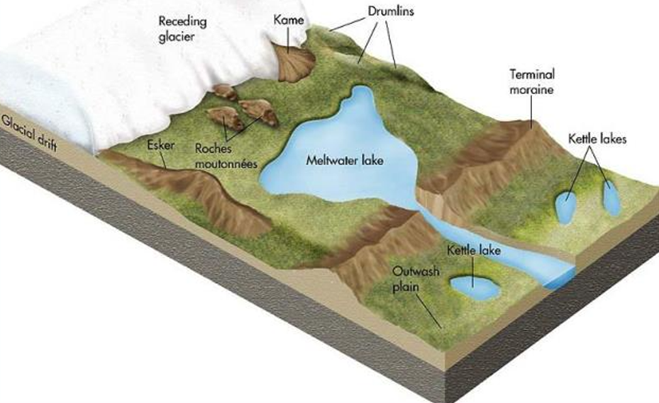
Glacio-Fluvial Deposits and Landforms

Imagine a mighty glacier descending from towering mountains, its icy surface gleaming under the sun. As it moves downward, it reaches a point where temperatures rise above freezing—the snow line. Here, the glacier begins to melt, and a network of small, rushing streams emerges from its snout (the glacier’s endpoint). This melting process is called Ablation.
The meltwater is not just water—it carries with it a mix of sand, gravel, and other sediments, rearranging the landscape as it flows. The landforms created by these glacial meltwater streams are called Glacio-Fluvial Landforms. These features are unique because they combine the sculpting power of ice (glaciers) with the depositing power of water (rivers).
Let’s take a journey through the landforms created by glacial meltwater.
Eskers
Imagine a long, winding ridge of sand and gravel, snaking its way across a glacial valley. This is an Esker—one of the most fascinating glacial landforms.
How Are Eskers Formed?
- When the glacier melts, streams form beneath the ice, flowing through tunnels.
- These subglacial streams carry sediment but get blocked by obstacles, forcing them to slow down and deposit their load.
- Over time, this deposited material forms a long, narrow, and winding ridge running parallel to the glacier’s direction.
Characteristics of Eskers:
✔ Found in the middle of glacial valleys.
✔ Steep-sided and composed of sorted sand and gravel.
✔ Can stretch for tens of kilometers.
✔ Often resemble a railway embankment!
🔹 Example: The Kelsey Esker in Canada, a prominent esker stretching over 100 km.
Kames
Now, imagine scattered, irregular mounds of sand and gravel near a melting glacier. These are Kames—small, steep hills formed by glacial meltwater.
How Do Kames Form?
- As a glacier melts, sediment-laden water pools in depressions on the ice surface.
- When the glacier finally disappears, these deposits are left behind as mounds.
Characteristics of Kames:
✔ Often found near the edges of retreating glaciers.
✔ Can look like miniature deltas if formed in lakes.
✔ Composed of layered (bedded) sands and gravels.
🔹 Example: The Kames of Scotland, seen across the glaciated landscapes of the UK.
Outwash Plains
Now, let’s move to the area in front of the melting glacier. Here, the meltwater flows out, carrying huge amounts of sediment and depositing it like a fan-shaped floodplain. This results in an Outwash Plain, also known as a Sandur.
How Are Outwash Plains Formed?
- When glacial meltwater flows out, it erodes the terminal moraine.
- The sediments spread out in layers beyond the glacier’s snout.
- Multiple meltwater streams merge, forming a broad, flat plain.
Characteristics of Outwash Plains:
✔ Found in front of terminal moraines.
✔ Made up of fine sand, gravel, and silt, sorted by water.
✔ Resemble the alluvial fans seen in river systems.
🔹 Example: Skeiðarársandur in Iceland, a vast outwash plain formed by meltwater from Vatnajökull Glacier.
Kettles and Hummocks
Now, picture a landscape of uneven, pitted terrain—small depressions dotting the landscape, some filled with water, and low mounds rising between them.
Kettles
- Sometimes, huge blocks of ice break off from the glacier and get buried under sediments.
- When the ice melts, it leaves behind a depression, known as a Kettle.
- If these depressions fill with water, they become Kettle Lakes.
Hummocks
- Large kettles are often surrounded by small, irregular mounds, called Hummocks.
- They form when uneven deposition occurs around melting ice blocks.
Characteristics:
✔ Kettles can be several meters deep.
✔ Hummocks create an undulating, bumpy landscape.
🔹 Example: The Kettle Moraine in Wisconsin, USA, a classic example of kettle lakes and hummocks.
Conclusion
Glaciers shape landscapes in two ways—first by eroding, then by depositing. The landforms they create through meltwater are unique, reflecting the interplay between ice and flowing water.


