
Introduction to Ocean Bottom Relief
The ocean floor, covering nearly three-fourths of the Earth’s surface, exhibits diverse and complex relief features, rivalling those found on land. Unlike the earlier belief that ocean bottoms are vast, featureless plains, modern studies reveal distinct topographical variations shaped by tectonic, volcanic, erosional, and depositional processes.
The ocean floor is broadly classified into four major divisions:
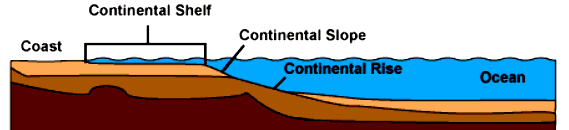
- Continental Shelf – A shallow, submerged extension of the continent.
- Continental Slope – A steep incline beyond the shelf, marking the boundary between continental and oceanic crust.
- Abyssal Plain – Vast, flat expanses at great depths.
- Oceanic Trenches – The deepest parts of the ocean, often associated with volcanic and seismic activity.
In addition to these, several associated features like ridges, seamounts, guyots, canyons, and coral reefs contribute to the ocean’s intricate relief. The following sections provide a detailed exploration of these features, highlighting their formation, characteristics, and significance.
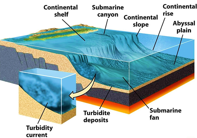
Understanding the Continental Shelf
Let’s say you are standing on a beach, looking out at the vast ocean. You might think that the land ends abruptly at the shoreline, but in reality, the continent extends further underwater before it takes a deep plunge. This submerged part of the continent, gently sloping into the ocean, is known as the Continental Shelf.
You can draw the following simple diagram in the exams, to illustrate ocean bottom relief features:
Visualizing the Continental Shelf
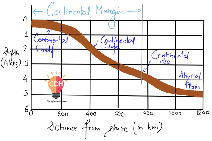
Let’s imagine you are on a journey underwater. If we start from the coast and begin walking into the sea, initially, we would notice a gradual slope. The depth increases, but very slowly. This underwater extension of the continent continues until we reach a point where the slope suddenly becomes steep—this is known as the shelf break. Beyond this, the ocean floor drops rapidly into the deep abyss.
The continental shelf is like a shallow, submerged border of the land, a transition zone between land and the deep ocean. It is not a uniform feature; its width and depth vary across different parts of the world.
Size and Variations
- The continental shelf covers about 7.5% of the total ocean area.
- On average, it is about 70 km wide, but this varies significantly.
- In some regions, like off the coast of South America (eastern Pacific), it is almost absent, while along the eastern coast of the USA, it stretches up to 120 km.
- In India, we see a similar variation:
- The western coast (Arabian Sea side) has a wider continental shelf, formed due to faulting and submergence.
- The eastern coast (Bay of Bengal side) has a narrower shelf, except near river mouths like those of the Ganga, Godavari, Krishna, and Cauvery, where delta formation has extended the shelf.
- Around Andaman & Nicobar, Lakshadweep, and the Gulf of Mannar, coral reefs have played a major role in shaping the shelves.
Formation and Composition
The continental shelf is mostly covered with sediments, which are brought in by rivers, glaciers, and ocean currents. These sediments settle over time, creating a relatively smooth sea floor. The depth at the seaward edge of the shelf generally ranges between 150-200 meters.
In some areas, especially where Fold Mountains run parallel to the coast (such as the Andes along the Pacific Ocean), the continental shelf is much narrower or even absent. This is because such coasts are geologically more active, leading to abrupt underwater slopes.
Importance of Continental Shelves
The continental shelves are one of the most productive and economically significant parts of the ocean. They play a crucial role in:
- Marine Life & Fisheries – Since sunlight can penetrate these shallow waters, marine plants (phytoplankton) thrive, forming the base of the food chain. As a result, continental shelves provide the richest fishing grounds in the world.
- Energy Resources – About 20% of the world’s petroleum and natural gas is extracted from the continental shelf. Many of the offshore drilling operations are located in these regions.
- Mineral Deposits – Sand, gravel, and other valuable minerals are found in abundance.
- Coral Reefs – These ecosystems, rich in biodiversity, are commonly found on continental shelves, adding to their ecological importance.
Conclusion
The continental shelf is not just a submerged extension of land—it is a dynamic, resource-rich zone that supports marine ecosystems, fuels economies, and helps us understand the geological history of our planet.
Continental Slope
Imagine standing on the edge of a vast plateau that suddenly drops off into a deep valley. This is exactly what happens beneath the ocean surface when the continental shelf ends and the ocean floor takes a dramatic plunge. This steep underwater descent is known as the Continental Slope—the true boundary between the continent and the deep ocean.
What is the Continental Slope?
- It is the seaward extension of the continental shelf, marking the transition from the shallow coastal waters to the deep abyssal plain.
- The depth varies from 200 meters to 2000 meters, making it a crucial boundary between the continental crust and the deep-sea basin.
- The continental slope accounts for 8.5% of the total ocean basin area.
A Steep and Mysterious Terrain
- If we were to dive down from the continental shelf, we would experience a sudden, steep descent—much like skiing down a mountain slope.
- The steepness of the slope prevents significant accumulation of sediments, which is why it appears more rugged and barren compared to the shelf.
- However, at the base of the slope, sediments carried from the shelf gradually settle, forming a region known as the Continental Rise—a buffer zone before the deep-sea abyss begins.
Unique Features of the Continental Slope
- The continental slope is often furrowed with deep canyons and trenches, carved by underwater currents and past geological activity.
- Unlike the shelf, marine life is scarce due to lower light penetration and reduced nutrient availability.
- It marks the end of the continental block, making it an important feature in understanding plate tectonics and oceanic boundaries.
Why is the Continental Slope Important?
- Though less biologically rich than the shelf, the slope is crucial for deep-sea currents and sediment transport.
- Some slopes, especially near subduction zones, are geologically active, leading to underwater landslides and earthquakes.
- They serve as pathways for deep-sea exploration and the study of oceanic trenches.
Conclusion
The continental slope is like an underwater cliff, marking the end of the continent and the beginning of the vast, mysterious deep ocean. While it lacks the richness of the continental shelf, it plays a crucial role in shaping ocean dynamics and offers a gateway to the hidden depths of our planet.
Abyssal Plains
Imagine traveling far beyond the continental shelf, past the steep continental slope, and over the gently sloping continental rise. Eventually, we reach a vast, featureless expanse—the Abyssal Plain, one of the least explored yet most widespread landscapes on Earth.
What are Abyssal Plains?
- These are the deep-sea plains found at depths ranging from 3,000 to 6,000 meters below the ocean surface.
- They are among the flattest and smoothest regions on Earth, covering nearly 40% of the ocean floor.
- Found in all major oceans, abyssal plains are created by the gradual accumulation of fine sediments that bury any irregularities, creating a level surface.
What Makes Abyssal Plains Unique?
Unlike land plains, abyssal plains are shaped by the continuous settling of sediments from rivers, marine organisms, and underwater landslides. Despite their vast emptiness, they are not entirely devoid of features.
Relief Features of Abyssal Plains
- Submarine Ridges
- These are enormous mountain chains rising from the abyssal plains, sometimes stretching thousands of kilometers.
- The Mid-Atlantic Ridge, part of a system that extends 75,000 km, is the longest mountain range on Earth—most of it hidden beneath the ocean!
- Some ridges even break the surface to form volcanic islands—for example, Iceland sits atop the Mid-Atlantic Ridge.
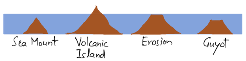
- Seamounts and Guyots
- A seamount is a submerged volcano with a sharp peak, often formed by volcanic activity over hotspots in the Earth’s crust.
- Some seamounts rise above sea level, forming islands—the Hawaiian and Tahiti Islands are exposed seamounts!
- If a seamount’s top gets flattened due to erosion by waves, it becomes a guyot (or tablemount)—a reminder of ancient volcanic activity now buried under the ocean.
Why are Abyssal Plains Important?
- Though they appear lifeless, abyssal plains harbor deep-sea ecosystems adapted to extreme pressure and darkness.
- They act as huge sediment storage areas, preventing sudden shifts in ocean currents.
- Scientists believe that abyssal plains may hold clues to Earth’s climate history, as sediments deposited over millions of years contain records of past environments.
Conclusion
The Abyssal Plains are the vast, hidden deserts of the deep ocean—seemingly lifeless yet full of geological wonders like ridges, seamounts, and guyots. Though they lie miles beneath the waves, they shape the structure of our planet and hold secrets that we are only beginning to uncover.
Oceanic Deeps or Trenches
Imagine standing at the summit of Mount Everest—the highest point on land, towering at 8,848 meters. Now, flip that image upside down and imagine an even deeper chasm beneath the ocean surface. That’s exactly what an oceanic trench is—the deepest and most mysterious part of the ocean.
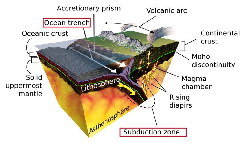
What are Oceanic Trenches?
- These are long, narrow, and steep-sided depressions found at the base of continental slopes, extending deeper than the surrounding ocean floor.
- They are the deepest parts of the ocean and are formed in subduction zones, where one tectonic plate is forced beneath another.
- Oceanic trenches are not randomly scattered across the oceans; they are mostly found near continents, not in the middle of ocean basins.
Key Characteristics of Oceanic Trenches
- Home to Great Earthquakes and Tsunamis
- Since they form in tectonically active regions, earthquakes and volcanic eruptions are frequent in and around these trenches.
- Many of the world’s deadliest tsunamis originate from seismic activity in these trenches.
- Mostly Found in the Pacific Ocean
- The Pacific Ocean has the highest concentration of trenches, earning it the title of the “Ring of Fire”, where powerful earthquakes and volcanoes shape the ocean floor.
- Mariana Trench: The Deepest Point on Earth
- Located near the Guam Islands in the Pacific Ocean, the Mariana Trench plunges down 11 km (deeper than Mount Everest is tall!).
- This depth is so extreme that if Mount Everest were placed inside the Mariana Trench, its peak would still be over 2 km underwater!
Why are Trenches Important?
- Geological Activity: They help scientists understand plate tectonics and the process of subduction, which drives the movement of continents.
- Biodiversity Hotspots: Despite the crushing pressure, icy temperatures, and complete darkness, unique life forms thrive in these trenches, such as deep-sea fish, giant squids, and microbes that survive on chemicals instead of sunlight.
- Natural Disaster Insights: Since tsunamis and major earthquakes originate from these regions, studying trenches helps in disaster prediction and mitigation.
Conclusion
Oceanic trenches are nature’s deepest scars, revealing the immense forces that shape our planet. They are tectonic battlegrounds where plates collide, giving birth to earthquakes, volcanoes, and tsunamis. While they remain one of the most unexplored regions of Earth, their study continues to unveil secrets about our planet’s past and future.
Submarine Canyons
Imagine the Grand Canyon, but instead of cutting through land, it lies deep under the ocean! That’s what a submarine canyon is—a deep, narrow trench carved into the continental shelf and slope, resembling a river valley on land. These hidden landscapes shape the seafloor just as rivers shape the continents, but their origin is a subject of much debate.
What Are Submarine Canyons?
- They are long, deep, and steep-sided valleys that cut through the continental shelf and slope.
- Some have a dendritic (branching) pattern, similar to river systems on land.
- Their courses are often sinuous (winding), like meandering rivers.
How Do Submarine Canyons Form?
There’s no single answer! Scientists have proposed three major theories, each with its strengths and weaknesses:
1. Diastrophic Theory (Faulting & Folding)
- Some believe that earth movements (caused by tectonic forces) create faults or folds, forming submarine canyons.
- Faulting (cracks in the Earth’s crust) could create these deep valleys, while synclines (folded rock layers) might also turn into canyons over time.
- Problems:
- Most submarine canyons are perpendicular to the coast, while faulting usually happens parallel.
- It doesn’t explain the dendritic (branching) patterns seen in many canyons.
- Not all regions with canyons have a history of faulting.
2. Subaerial Erosion Theory (Rivers & Submergence)
- Some scientists compare submarine canyons to river valleys on land, suggesting they were carved by rivers before being submerged due to rising sea levels.
- These valleys may have been formed millions of years ago when sea levels were much lower.
- Problems:
- This theory would require continents to have been thousands of feet higher before sinking.
- If true, these canyons should continue onto land, but many don’t.
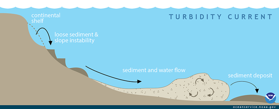
3. Turbidity Current Theory (Underwater Landslides)
- Turbidity currents—fast-moving underwater flows of sediment-laden water—could erode the seafloor and carve these canyons.
- These currents, triggered by storms, earthquakes, or strong onshore winds, carry massive amounts of sand and silt, grinding away at the seafloor like underwater sandblasters.
- Problems:
- Some argue that turbidity currents aren’t strong enough to carve such deep and long canyons.
Why Are Submarine Canyons Important?
- They act as underwater highways for sediments, transporting material from continents into the deep ocean.
- They influence marine ecosystems, serving as habitats for deep-sea life.
- They play a role in fisheries, as nutrient-rich waters from deep sea up-well along their slopes, supporting marine food chains.
Conclusion
Submarine canyons remain one of the great geological mysteries of the ocean. Whether formed by ancient rivers, tectonic movements, or underwater landslides, they continue to shape the seafloor and impact marine life in profound ways. Understanding them helps us decode Earth’s history, predict underwater landslides, and even locate deep-sea resources!