
Introduction to World Mapping

Let’s begin with a basic yet profound question:
Why learn to draw the World Map by hand when we already have printed and digital maps?

The answer lies in the analytical ability and mental map-building that this exercise fosters. A civil services aspirant should not just see the world, but should be able to mentally navigate it—understand patterns, relationships, and significance of spatial arrangements.
So, let’s begin our journey—not just of drawing lines on paper, but of decoding the spatial logic of our planet.
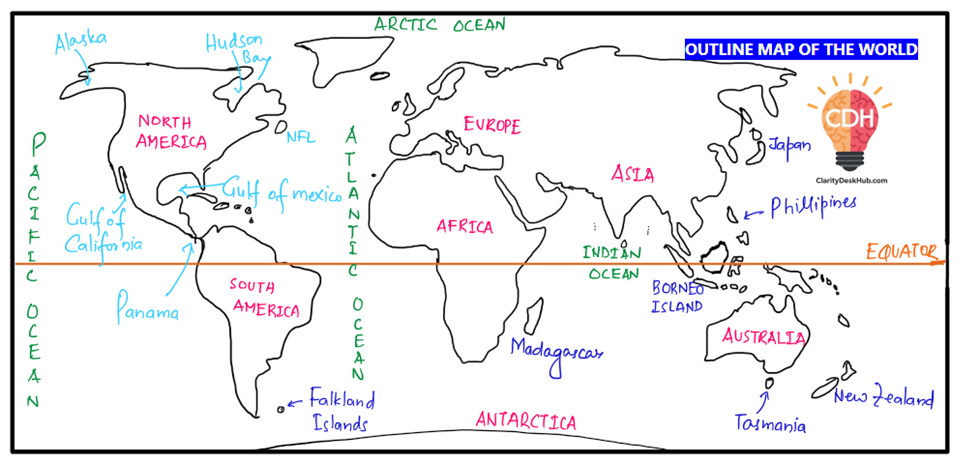
I suggest that you first observe the following hand-drawn map and analyze the procedure for drawing a simple world map diagram, which is, of course, not to scale. 😊
🗺️ Step-by-Step: Drawing the Outline of the World Map
North America
We begin with North America, as it provides a relatively easy anchor to start from.
- Gulf of Mexico – A prominent coastal indent in southeastern North America.
- Move north-east to draw Newfoundland Island (eastern Canada).
- Then mark the Canadian Shield – a large geological core.
- North-east from here is Greenland – the world’s largest island, a part of the Kingdom of Denmark.
↳ Slight detour:
- Insert the Hudson Bay inside Canada.
- Then stretch towards Alaska – an American state once sold by Russia to the USA in 1867.
- Go downwards to the Gulf of California.
Now draw a narrow connection:
- The Isthmus of Panama – a slender land bridge that connects North America to South America.
South America
- Begin sketching South America connected at Panama.
- A key geographical detail: The Equator passes through this continent.
- Upper part of the Equator lies in the Northern Hemisphere (NH),
- Lower part lies in the Southern Hemisphere (SH).
- So, South America straddles both hemispheres.
A helpful mental image: It looks like an ice-cream cone tilted slightly to the east.
Africa – Cradle of Humanity
Shift east to draw Africa – our next foundational block.
- Remember: Africa is the birthplace of human evolution.
- It is often called the “Dark Continent” – a term from colonial times, referring to unexplored interiors (not skin color).
Africa too is bisected by the Equator, and sits almost symmetrically around it.
Middle East and Asia
Now move northeast:
- Draw the Arabian Peninsula – a roughly rectangular landmass.
- Then move into Asia – the largest and most populous continent.
Proceed to draw:
- China and Russia in the northern part of Asia.
South-East Asia – Island Diversity
An important and dynamic region:
- Sketch the island of Borneo – shared by three countries: Malaysia, Indonesia, and Brunei.
- Just north of Borneo: the Philippines.
- Further north: Japan – a country made up of four major islands, known for its development and seismic activity.
The Indian Subcontinent and Nearby Islands
Below the Indian mainland:
- Sri Lanka – a teardrop-shaped island nation.
- Two Indian Island groups:
- Andaman & Nicobar Islands – in the Bay of Bengal.
- Lakshadweep Islands – in the Arabian Sea.
Island Chains around Africa
Bottom-right of Africa:
- Madagascar – fourth largest island in the world.
- Further right: Mauritius – a country with a majority of Indians. (not labelled)
- Above that: Seychelles – an island country in the Indian Ocean. (not labelled)
Islands around South America and Africa
- West of Africa: Canary Islands – belong to Spain. (not labelled)
- Right of South America: Falkland Islands – a British Overseas Territory (also known for the 1982 war between UK and Argentina).
Australia – The Island Continent
- Sketch Australia, often dubbed the “island continent”.
- Near it:
- Tasmania – part of Australia.
- New Zealand – to the southeast.
🔍 Special Note: Read about Zealandia, a submerged continent, parts of which are visible as New Zealand. Often appears in current affairs.
Europe
- Europe should be drawn carefully (refer to maps for accuracy) – it’s more intricate due to multiple peninsulas and borders. But for drawing this outline in exams, map level accuracy is not required, a rough sketch is enough.
Antarctica
- Finally, draw Antarctica at the southernmost end of your map.
Now let’s reflect on some analytical observations.
🌐 Analytical Insights from the World Map
1. Hemispheric Asymmetry of Landmasses
- Most of the Earth’s land is concentrated in the Northern Hemisphere.
- An Irony you should notice for fun😊:
- The North Pole lies in the Arctic Ocean (a water body).
- The South Pole lies on Antarctica, a landmass covered in ice.
Oceans of the World
- Atlantic Ocean – Think of it as S-shaped, running between the Americas and Europe-Africa.
- Pacific Ocean – The largest ocean, spread across the eastern Asia-western Americas.
- Indian Ocean – The only ocean named after a country.
- Southern Ocean – Found below 60°S latitude, surrounding Antarctica.
📝 Note: Indian Ocean is sometimes called a semi-ocean due to its partially enclosed nature.
🧊 Ice Ages and Glaciation – Pleistocene Epoch
About 30,000 years ago, during the Pleistocene Ice Age, nearly one-third of the Earth’s surface was covered with ice. The landmasses beyond the temperate zones, especially in the higher latitudes, were buried under massive ice sheets. Even today, Antarctica and Greenland remain as major remnants of that glaciated era, still hosting vast reserves of permanent ice.
In the northern regions of Canada, as the climate gradually warmed, these thick ice sheets began to melt. This melting process caused cracks and depressions to appear in the Earth’s surface—a phenomenon much like how ice in a freezer breaks apart as it melts. Over time, these cracks and depressions got filled with freshwater, leading to the formation of numerous glacial lakes that are still visible in the Canadian Shield and surrounding regions today.
✅ Conclusion
This practice of world mapping is not merely a drawing exercise.
It is a process of internalizing the geography of the planet, of appreciating how land, water, and life interact. For a UPSC aspirant, this knowledge is not optional—it is foundational.
Through this practice, you:
- Sharpen your spatial memory
- Enhance your map-based answer writing
- Gain a global perspective that is crucial for subjects like Economic Geography, International Relations, and Environment.


