
Longitudinal Profile: The Vertical Journey of a River

Imagine you are following a river’s journey from its source (like a glacier or spring in the mountains) to its mouth (where it meets the sea, ocean, or lake). If you could slice the river vertically and observe its entire length from the side, the resulting profile is called the Longitudinal Profile or Long Profile of a river.
What Does the Longitudinal Profile Show?
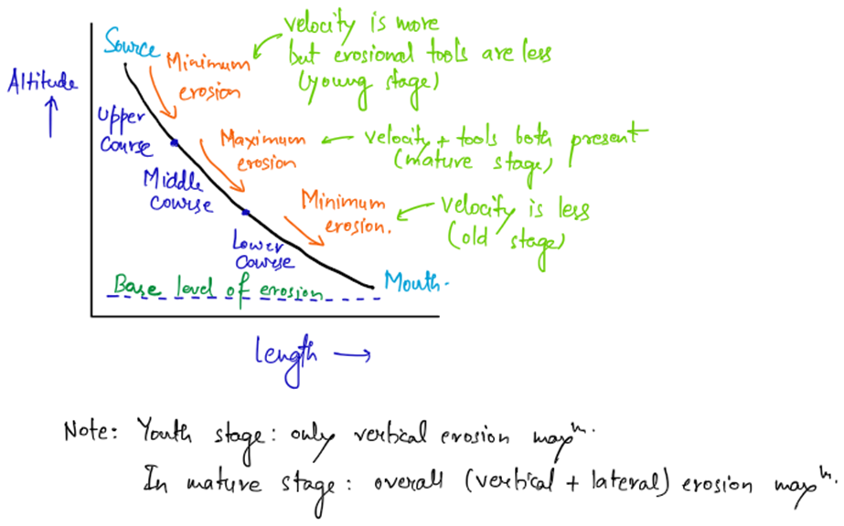
The longitudinal profile visually represents the gradient (slope) of the river from source to mouth. Ideally, it appears as a smooth concave curve — steep near the source, moderate in the middle course, and almost flat near the mouth.
Why Does the Profile Have a Concave Shape?
The concave shape of the longitudinal profile is a result of the river’s ability to erode and transport sediments differently across its course:
- Upper Course (Near Source):
- Minimal Erosion – Since the river originates from a glacier or spring, there is a lack of sufficient water volume and erosional tools (like sediment and rocks). Hence, erosion is minimal.
- The river relies more on vertical erosion, creating deep valleys.
- Middle Course:
- Maximum Erosion – This section has the highest water volume, flow velocity, and sediment load. The combination of these factors results in maximum erosion, deepening and widening the valley floor.
- This is why most valleys are broader and more defined in the middle course.
- Lower Course (Near Mouth):
- Minimal Erosion – As the slope becomes gentle and the river loses energy, its ability to erode decreases significantly.
- The river mainly deposits sediments instead of eroding.
Why Does the River Aim for a Smooth Profile?
A river naturally attempts to create a smooth, concave profile because it wants to maintain a balance between erosion, transportation, and deposition. If any irregularity (like a sudden slope change or obstruction) appears, the river either erodes it or deposits material to restore the balance.
So, the longitudinal profile is essentially the river’s way of adapting to its landscape to efficiently transport its sediment load downstream.
Grading of a River Channel and Profile of Equilibrium: The River’s Quest for Balance
Consider a river, carrying a load of sediment (sand, gravel, rocks) from its source to its mouth. Now, if the load is perfectly balanced with the river’s energy (flow velocity), the river flows smoothly without any major changes in its channel profile. This balanced state is known as the Graded Condition of a River, and the resulting smooth, concave long profile is called the Profile of Equilibrium.
In simple terms, a graded river is one where the transporting capacity of the river matches the sediment load, allowing it to neither erode too much nor deposit excessively. This balance ensures smooth and steady transportation of sediments downstream.
Why Is It Called Profile of Equilibrium?
The term equilibrium signifies a state where:
- The river has just enough energy to transport the available sediment load.
- There is neither excessive erosion (degradation) nor excessive deposition (aggradation).
- If the equilibrium is disturbed, it may cause floods, deposition, or excessive erosion.
Factors Affecting Grading of a River
Achieving this balance (grading) is not solely dependent on the channel gradient (slope). Other factors like sediment load, volume of water, discharge, and velocity also play a crucial role. Let’s understand them:
Case I: Variation in Sediment Load
- If sediment load decreases → The river now has more energy than required to carry its load. This excess energy is used for valley incision (deepening the channel) — a process called degradation.
- Result: The channel gradient decreases as the river cuts deeper.
- If sediment load increases → The river’s energy becomes insufficient to carry the excess load, causing deposition of sediments. This is called aggradation.
- Result: The channel gradient increases due to sediment accumulation.
- Balanced Condition → The load and energy match, maintaining a graded profile.
Case II: Variation in Volume of Water
- If water volume increases (while sediment load and gradient remain constant) → The transporting capacity of the river increases, causing rapid erosion and deepening of the valley, disturbing the equilibrium.
- If water volume decreases → The flow velocity and discharge reduce, decreasing the river’s ability to carry sediments. This leads to sediment deposition, causing aggradation and an ungraded profile.
Case III: Variation in Channel Gradient
- If channel gradient increases (keeping load and water constant) → Flow velocity increases, causing rapid erosion (degradation), disrupting equilibrium.
- If channel gradient decreases → Flow velocity decreases, causing sediment deposition (aggradation), again disturbing equilibrium.
The Essence of Graded Condition
A river constantly strives to maintain its graded profile by adjusting its flow, sediment load, and channel gradient. If any one of these elements changes, the river either erodes (degrades) or deposits (aggrades) until balance is restored.
So, a graded river is like a perfect delivery system — not too fast, not too slow — carrying its load steadily without disruption. This state of balance is the Profile of Equilibrium. However, natural events like floods, landslides, or climate changes can often disturb this balance, forcing the river to readjust itself.
Regrading of a River and Regraded Profile of Equilibrium
As we’ve discussed earlier, a river always strives to maintain a graded profile, where its transporting capacity matches its sediment load. However, nature is dynamic, and changes in factors like channel gradient, sediment load, water volume, or sea level can disturb this balance, causing the river to adjust itself again. This process of adjustment is called regrading of a river, and the new profile formed after attaining balance is called the regraded profile of equilibrium.
In simple words, when a river’s equilibrium is disturbed due to external factors, it doesn’t give up — instead, it starts working again to form a new balance, deepening or depositing sediments as required. This constant process of adjustment is known as rejuvenation, meaning the river gains new energy and starts reshaping itself.
Major Causes of Regrading (Rejuvenation)
The most common factor that disturbs the river’s balance is a change in channel gradient, which can happen due to:
- Fall in sea level (at the mouth of the river).
- Reduced sediment load (in the middle course).
- Reduced sediment supply from the headwaters (upper course).
Let’s understand each one with a clear perspective:
1. Rejuvenation at the Mouth of a River
What happens here?
- Suppose the river had already achieved a smooth graded profile, and suddenly the sea level falls (perhaps due to tectonic activity or glacial melt).
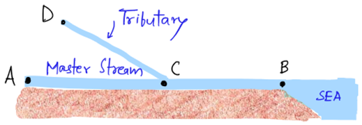
- Now, the mouth of the river(Point B) is at a lower base level, causing the channel gradient to steepen.
- This steep slope increases the flow velocity, and the river gains new energy.
- The river now starts aggressively deepening its valley at the mouth, trying to adjust to the new sea level (new base level).
- This new aggressive erosion is called valley incision, and the resulting profile is called the regraded profile of equilibrium.
Example:
- If the sea level of the Bay of Bengal (where the Ganga River drains) were to fall, the gradient of the river at its mouth would increase, causing a rise in flow velocity and erosive power.
2. Rejuvenation in the Middle Course of a River (Due to Sediment Load Reduction)
What happens here?
- Imagine a tributary (a smaller river joining the main river) suddenly reduces its sediment supply to the main river(at Point C)
- Now, the main river has less sediment to carry but the same amount of energy.
- This surplus energy that was earlier spent in transporting sediments now shifts to erosion, deepening the valley downstream from the confluence (meeting point).
- This renewed erosion disturbs the previous graded profile, causing the river to regrade its course.
- The upper part of the river gradient steepens, leading to headward erosion (erosion progressing towards the source).
Example:
- If a major tributary of the Ganga (like the Yamuna) suddenly carried less sediment, the Ganga’s middle course would experience higher erosion and valley deepening.
3. Rejuvenation in the Headwaters of a River (Due to Sediment Supply Reduction)
What happens here?
- In the upper course (headwaters) of a river, sediment supply plays a major role in balancing the profile.
- If the sediment supply at point A decreases (due to deforestation, less rainfall, or reduced glacial melt), the upper course becomes under-loaded.
- This triggers excess energy in the river, which is now used for aggressive vertical erosion.
- As a result, the entire river valley starts deepening — from source to mouth — causing a disturbance in the graded profile.
- Over time, the river regrades itself, creating a new profile of equilibrium.
Example:
- If the Himalayan glaciers supplying sediments to the Ganga shrink significantly, the river would experience deep valley incision across its entire course.
Why Does Regrading Occur?
In simple terms:
- Any change in channel gradient, water volume, or sediment load disturbs the graded profile.
- The river, with its natural tendency, starts adjusting itself by either:
- Deepening the valley (degradation).
- Depositing sediments (aggradation).
- Eventually, a new balance is achieved, forming the regraded profile of equilibrium.
✅ The River Never Stops Working
The concept of regrading teaches us that a river is like a tireless laborer. No matter how many times nature disturbs its balance — by changing sea level, reducing sediment load, or altering its gradient — the river will always strive to find a new balance, deepening or depositing sediments accordingly. This dynamic balance is what keeps reshaping valleys, floodplains, and river courses over time.


