
Overview of African Continent
When discussing Africa, one must remember: Africa is not just a continent—it is the cradle of humanity, the epicenter of raw geography, and a theater where natural and human histories have collided for millennia.
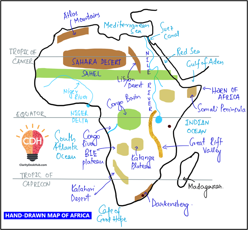
In your mental map, picture Africa not merely as a landmass, but as a vast plateau bordered by seas and gulfs, dissected by rift valleys, girded by deserts, pierced by rivers, and crowned by volcanic peaks. Every corner of this continent pulses with contrast—from the icy peaks of Mount Kilimanjaro to the sun-scorched Sahara, from the rain-drenched Congo Basin to the windswept Namib coast.
Let’s begin the African journey not from the center, but from the edges—from the waters that frame and influence it.
🌊 The Maritime Borders – Africa’s Encircling Waters
Africa is almost an island, surrounded on all sides but one (northeast via Sinai Peninsula). To the north lies the Mediterranean Sea, a historic waterway that connected Africa to Europe and Asia. The Suez Canal, at the continent’s northeastern edge, isn’t just a chokepoint of maritime trade—it is also a geopolitical keystone linking the Red Sea to the Mediterranean, and thereby the Indian Ocean to the Atlantic via European routes.
To the east, the Red Sea and the Gulf of Aden separate Africa from the Arabian Peninsula. This narrow corridor—home to pirate-infested waters and strategic straits like Bab-el-Mandeb—is today the focus of global naval attention.
Further south, the Indian Ocean caresses the eastern coastlines of nations like Somalia, Kenya, Tanzania, Mozambique, and South Africa. Rich in trade winds, ocean currents, and monsoonal exchanges, this coast has for centuries been a melting pot of African, Arab, Persian, Indian, and even Chinese interactions. The island of Madagascar, with its unique biodiversity and cultural blend, stands as a natural extension of this Afro-Asian synthesis.
To the west, the Atlantic Ocean opens toward the Americas. Coastal cities like Dakar, Accra, and Luanda sit at crossroads of history—where colonial ships docked, where slave routes emerged, and where modern trade now flows.
At its southern tip, the Cape of Good Hope remains an iconic maritime marker—once feared by sailors, now revered in shipping routes connecting Europe to Asia.
🧭 Latitudinal Spread and Climatic Zones
Africa straddles the Equator, granting it a largely tropical identity. But unlike South America, Africa stretches well into both hemispheres. The Tropic of Cancer passes through the northern belt (Sahara), while the Tropic of Capricorn slices through its southern reaches (Namibia, Botswana, South Africa).
This span across major latitudes gives Africa every climate zone from equatorial rainforests to Mediterranean coasts, from arid deserts to alpine zones, and from humid savannas to temperate plateaus.
But more than just weather, these latitudinal belts also shaped ancient migrations, modern agriculture, and geopolitical fault lines—why northern Africa leans toward Arab-Islamic culture, while sub-Saharan Africa remains linguistically and ethnically diverse.
🗺️ Continental Shape and Regional Divisions
Africa’s very shape has shaped its fate. With a relatively smooth coastline (few natural harbors), it historically had limited maritime penetration—one reason for its delayed industrial integration. But its interior plateaus and natural barriers—like the Sahara, the Congo rainforest, and the Ethiopian Highlands—fostered isolated development of civilizations.
The continent is conventionally divided into five regions:
- North Africa – Bordered by the Mediterranean and the Sahara, this region ties deeply with the Arab world and Mediterranean history.
- West Africa – Known for its Sahelian struggles and resource wealth (gold, oil, cocoa), it’s a zone of dense population and vibrant cultures.
- Central Africa – Dominated by the Congo Basin, one of the world’s most biodiverse zones, and marked by dense forests and difficult terrain.
- East Africa – A region of rift valleys, great lakes, and savanna ecosystems, but also the scene of earliest human evolution.
- Southern Africa – A mineral-rich and politically complex region, balancing between developed cities and deep-rooted inequalities.
🪔 A Cradle of Humanity, Not Just Geography
Africa is where humanity began—home to “Lucy,” the 3.2-million-year-old Australopithecus fossil, discovered in Ethiopia’s Afar region. The Great Rift Valley, running from the Red Sea down through Kenya, Tanzania, and Malawi, is not just a tectonic marvel but a timeline of human evolution.
Africa’s geography is thus more than physical—it’s deeply anthropological, shaping the earliest tools, migrations, and settlements of Homo sapiens.
🛤️ Colonial Carvings, Post-Colonial Legacies
While this series focuses on physical geography, Africa’s political geography is inseparable from colonial interventions. The infamous Berlin Conference of 1884-85, in which European powers carved the continent without African consent, left behind borders that cut across ethnic, linguistic, and ecological zones.
Even physical mapping must consider:
- Why landlocked countries like Chad or Mali suffer from developmental constraints.
- How coastal resource access, like oil-rich Nigeria or Angola, drives regional tensions.
- Why rivers like the Nile are not just physical features, but political bargaining tools between upstream and downstream states (e.g., Ethiopia and Egypt).
🌐 Africa and the World – A Continent Reconnecting
Africa today is a continent of contrasts. Despite decades of underdevelopment, it is now a geopolitical hotspot:
- China’s Belt and Road Initiative sees massive infrastructure investment in ports and railways (Djibouti, Kenya).
- The African Union dreams of continental integration, with the AfCFTA (African Continental Free Trade Area).
- Climate change debates increasingly feature Africa’s vulnerability and potential, especially regarding Sahel desertification, rainforest protection, and renewable energy capacity.
From a mapping perspective, you’ll find critical chokepoints (Strait of Gibraltar, Suez Canal), natural resources (oil in Gulf of Guinea, diamonds in Botswana, cobalt in DRC), and ecological treasures (Serengeti, Okavango Delta, Sahara oases).
🧭 Conclusion – Mapping Africa is Mapping Complexity
To map Africa is to chart not just terrain but time—to trace ancient tectonic scars, follow winding rivers, mark historical trade routes, and understand why the Horn of Africa burns while the Congo flows in silence.
As we move into the detailed study of Africa’s mountains, deserts, rivers, plateaus, and ecological zones, remember: every physical feature carries a story of survival, sovereignty, and soul.
This is Africa—the continent that shaped us, and continues to challenge and inspire us.