
Overview of European Continent
Let us begin with a simple question:
What do you imagine when you hear “Europe”?
Perhaps art, history, the Industrial Revolution, or even the EU and football. But here, we are studying Europe not through its cultural lens but its geographical personality—its location, boundaries, countries, islands, lakes, and mountains.
Europe is not just a continent—it is a civilizational compass, a stage where the ideas of democracy, empire, war, and unity have all played out. Unlike Africa, whose vastness embodies raw natural energy, Europe embodies refined historical layering—its geography intertwined with the march of ideas, empires, revolutions, and integration.
To map Europe is to map both the physical and the philosophical, the land of peninsulas and plains, and the mindscape of nationalism, colonialism, and cosmopolitanism. Let’s begin this journey not from the heart of Europe but from its edges and tensions—from its peninsular identity to its tectonic peripheries.
🧭 Europe: A Peninsula of Peninsulas
Geographically, Europe is more an extension of Eurasia than a standalone continent. Yet it is treated as distinct, precisely because its borders are more historical than geological.
- To the north, it meets the Arctic Ocean, creating icy frontiers like Scandinavia and Russia’s Kola Peninsula.
- To the west, the Atlantic Ocean offers both opportunity and isolation; it forged sea empires (Portugal, Spain, Britain) and set Europe’s age of exploration in motion.
- To the south, the Mediterranean Sea forms a civilizational cradle. From ancient Greece and Rome to the Islamic conquests and the Crusades, this sea connected three continents—Europe, Asia, and Africa.
- To the east, the boundary becomes blurry. The Ural Mountains, Ural River, and the Caspian Sea are often cited as the dividing lines between Europe and Asia—but this is a man-made choice, not a natural necessity.
Europe’s very fragmentation—into peninsulas (Iberian, Italian, Balkan, Scandinavian), islands (British Isles, Sicily, Corsica), and inland seas (Baltic, Adriatic, Black)—has historically encouraged distinct identities and competitive polities. Geography shaped Europe into a continent of states, not a singular empire.
🏞️ Topography That Shaped History
Europe’s physiography doesn’t just explain climate or vegetation—it explains wars, empires, and alliances.
- The North European Plain, stretching from France to Russia, is a corridor of commerce and conquest. Napoleon and Hitler marched through it—so have goods, armies, and ideas.
- The Alps and Carpathians have historically shielded southern Europe from the north, while the Pyrenees form a cultural boundary between France and Spain.
- The Danube River, second longest in Europe, passes through more countries than any river on Earth—binding Central and Eastern Europe in a watery web of trade, migration, and conflict.
- The Rhine is not just a river—it’s the industrial spine of Europe, crucial to German-French relations.
- Mountains like the Urals and Caucasus, and water bodies like the Black Sea, are not just features—they’re geopolitical zones where Europe negotiates its eastern limits with Asia and Russia.
🌡️ Climate Bands and Cultural Zones
Europe lies entirely in the temperate zone, but variations abound:
- Mediterranean south: hot dry summers and cultural legacies of Greece, Rome, and later Islamic and Christian exchanges.
- Oceanic west (UK, France, Germany): moderate climates with deep industrial histories.
- Continental interiors (Poland, Hungary, Ukraine): harsh winters and strong agrarian traditions.
- Nordic north: subarctic forests, fjords, and societies built on welfare, wood, and wind.
These climatic zones mirror civilizational distinctions: Catholic-Protestant divides, capitalist-socialist transitions, democratic-authoritarian legacies.
Have you heard about fjords
🕰️ Historical Geography: Where Borders Tell Stories
No continent has redrawn its borders as often as Europe:
- The Peace of Westphalia (1648) gave rise to modern nation-states.
- The Napoleonic Wars redrew maps in the name of revolutionary ideals.
- World War I and II fragmented empires (Ottoman, Austro-Hungarian), created new nations (Yugoslavia, Czechoslovakia), and led to artificial constructs that later collapsed.
- The Cold War split Europe into East and West, marked starkly by the Iron Curtain and Berlin Wall.
- The fall of the USSR (1991) and the Balkan conflicts (1990s) reshuffled Eastern Europe’s geography.
- Today, EU and NATO expansions continue to reshape regional alliances and borders (e.g., Ukraine’s pivot westward, Turkish EU ambitions, Brexit’s aftermath).
Geography, in Europe, is not static—it is negotiated, challenged, and reimagined.
🇪🇺 Europe’s Political Experiments and International Reach
Europe is the birthplace of both colonialism and cosmopolitanism.
- While nations like Britain, France, Portugal, and the Netherlands built global empires, today Europe experiments with post-national governance via the European Union (EU).
- The Schengen Zone, Eurozone, and NATO demonstrate attempts to transcend the geography of borders.
- Yet, tensions remain: Brexit, Catalonian separatism, migrant crises, and Russia’s ambitions in Ukraine and the Baltics remind us that Europe’s geography is still political currency.
Europe may be geographically small, but it is politically weighty—controlling institutions, currencies, and norms that affect global governance.
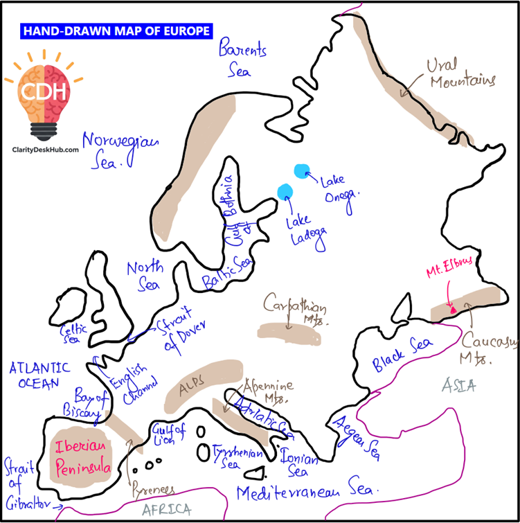
🗺️ Strategic Locations and Mapping Highlights
As you prepare to map Europe, remember key features that define geopolitical realities:
- Chokepoints: Strait of Gibraltar (Mediterranean-Atlantic), Bosphorus and Dardanelles (Black Sea access), English Channel (Anglo-European trade)
- Mountain barriers: Alps, Carpathians, Pyrenees, Apennines
- River arteries: Rhine (Western industry), Danube (Central-Europe binding), Volga (Russian heartland)
- Peninsulas: Iberian, Italian, Balkan, Scandinavian—each shaping regional cultures and maritime routes
- Island geopolitics: Cyprus (East Mediterranean tensions), Iceland (Arctic access), British Isles (Atlantic pivot)
- Borderlands: Baltics, Balkans, Eastern Europe—all flashpoints of identity and alignment
Ok, so having a strong foundation, I hope you are ready to delve deeper into the detailed study of European continent physiographic features. So Let’s move ahead.
Very Nice.