
Overview of North America Continent: A Brief Introduction

To truly understand any continent, we follow a golden thumb rule:
“Begin from the borders—the water bodies—then move inward to understand the core physiography.”
✏️ Drawing the Outline
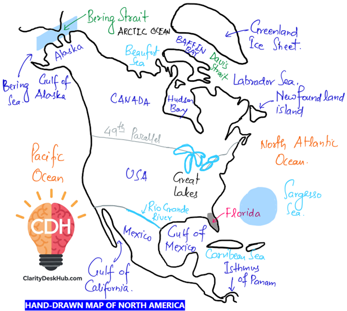
Refer to the figure above and take note of the key locations. As you go through the discussion, follow along using the hand-drawn map for better understanding. While this sketch is a rough representation and not to scale, it can serve as a valuable visual aid in exams, helping to enrich your answers with illustrative maps
To begin understanding the layout of North America, it’s helpful to fix our mental map using a central reference point: the Gulf of Mexico. Think of this gulf as the “bellybutton” of the continent—an easily identifiable and centrally located feature from which we can expand our understanding in all directions.
Moving in the northeast direction, we encounter several prominent geographical entities. The island of Newfoundland lies just off the eastern coast of Canada, acting as a gateway to the Atlantic. Inland, the vast Canadian Shield dominates the eastern and central part of Canada. This ancient rocky landmass, often referred to as the continent’s geological basement, surrounds the expansive Hudson Bay, which serves as a massive inland sea carved into the shield. Further northeast lies Greenland, geographically a part of North America, although politically administered by Denmark. Separating Greenland from Canada are major water bodies such as the Labrador Sea, Davis Strait, and Baffin Bay, all important for Arctic and North Atlantic circulation.
Turning to the northwest, we find Alaska, the far-flung yet integral part of the United States. This region is bounded by cold northern waters including the Beaufort Sea to the north, and the Bering Sea to the west, separated from Russia by the narrow Bering Strait. These waters are crucial for both climate and marine biodiversity, besides holding geopolitical significance.
In the south and southeast, the physical landscape transforms yet again. The Gulf of California nestles between the Baja California Peninsula and Mexico’s mainland, serving as a distinct marine inlet. The Isthmus of Panama, a narrow land bridge, connects North America with South America, making it a strategic chokepoint and a biological corridor. Further northeast lies Florida, a prominent southeastern peninsula of the U.S., which juts out toward the Caribbean Sea, where we find the island nation of Cuba. Mexico’s Yucatán Peninsula also protrudes into the Caribbean, opposite Cuba, adding to the region’s distinctive geography. Beyond these lies the Sargasso Sea, an unusual part of the Atlantic Ocean known for its calm waters and floating Sargassum seaweed, maintained by the circulating oceanic gyre.
Now, shifting focus inward, we come across a few important geopolitical and imaginary lines. The 40th Parallel North serves as a key latitudinal marker often referenced in geographical divisions and mapwork, sometimes aligning with parts of the Canada–U.S. border. Adding to the political geography, the Rio Grande River forms a natural boundary between the United States and Mexico, highlighting the role rivers play not only in shaping landforms but also in demarcating territories.
Now let’s take an overview of important physiological regions of North America in brief:
💎 The Great Lakes – Urban Heartland of North America
A vital physiographic and economic zone:
🏞 Five Major Lakes (West to East):
- Superior – Largest freshwater lake globally
- Michigan – Entirely within the U.S.
- Huron
- Erie
- Ontario
🏙 Urban-Industrial Significance:
We have already studied in the Industry section if you remember: The Great Lakes region stands out as one of the most urbanized and industrially vibrant zones in North America. Cities like Detroit, Chicago, Cleveland, and Toronto emerged as economic powerhouses, thanks to the early availability of iron and coal deposits in the surrounding areas.
This natural resource advantage laid the foundation for a booming steel industry, with Pittsburgh becoming a symbol of heavy industrial growth. As steel production took off, it created a ripple effect—Detroit, famously known as the “Motor City,” became the hub of automobile manufacturing, shaping America’s industrial identity. This industrial growth also influenced the rise of New York as a global center for finance, and Washington D.C. as the administrative heart of the nation.
Together, these cities formed an interconnected web of industry, innovation, and governance—all rooted in the geographical blessings of the Great Lakes basin.
We shall read about Great Lakes region in detail in later sections with illustrative maps
🏔 Physical Divisions of North America

The physical geography of North America is broadly categorized into three major divisions: the Western Cordillera, the Central Lowlands, and the Eastern Highlands. Each of these has distinct landforms, geological histories, and geographical significance.
The Western Cordillera is a dramatic landscape formed by a series of parallel mountain ranges, often accompanied by intermontane plateaus and valleys. This vast mountainous belt runs along the western edge of the continent. In the far north, the Brooks Range dominates Alaska, while further south lies the Alaska Range, which hosts Mount McKinley (Denali)—the highest peak in North America. The Rocky Mountains extend from Canada deep into the United States, forming the backbone of the Cordillera. Along the Pacific coast, the Cascade Range, Sierra Nevada, and the Coast Ranges contribute to the region’s rugged terrain. In Mexico, this mountain chain continues as the Sierra Madre. Volcanism is an active feature in this region; notable peaks like Mount Shasta and Mount Hood (both part of the Cascade Range) are active volcanoes. These features will be examined in greater detail in the subsequent section.
Moving eastward, the Central Lowlands stretch across the heart of North America, characterized by broad, flat plains. These plains support a variety of landforms and water bodies. In the northern part of the region, several major freshwater lakes such as the Great Bear Lake, Great Slave Lake, Lake Athabasca, Reindeer Lake, and Lake Winnipeg form a crucial part of Canada’s interior drainage system. These lie to the north of the Great Lakes. The lowlands are also home to some of the continent’s major rivers. The Mississippi River System, which culminates in a bird-foot delta at the Gulf of Mexico, dominates the central drainage. The Churchill River flows across Canada, while the Yukon River in the northwest is historically known for its placer gold deposits—akin to India’s Subarnarekha. The Colorado River is renowned for carving deep canyons through the rock, most famously the Grand Canyon, a masterpiece of river erosion. A quick geographical distinction: a canyon is typically wider and U-shaped, while a gorge is narrower and V-shaped—much like the canyon on the Godavari River in India.
Finally, the Eastern Highlands consist of ancient fold mountains that, while not as elevated as their western counterparts, are rich in minerals. The Appalachian Mountains, among the oldest mountain ranges in the world, are heavily eroded but remain geologically significant due to their mineral wealth. Adjacent to them is the Canadian Shield, also known as the Laurentian Plateau. This vast expanse of ancient igneous rocks is one of the oldest geological formations on Earth and is a repository of valuable metallic minerals. The St. Lawrence River, which connects the Great Lakes to the Atlantic Ocean, flows through this region and serves as a vital trade route, enabling navigation between inland North America and the sea.
Other Important Features of North America Continent:
The Prairies of North America, often referred to as the “Granary of the World,” are expansive temperate grasslands that stretch across the central parts of the United States and Canada. This biome is characterized by flat terrain and deep, fertile soils, making it one of the most productive agricultural regions on Earth. Crops such as wheat and corn are cultivated extensively here, supporting both domestic consumption and global food supply chains.
Moving northeast, the island of Newfoundland is geographically significant for its unique oceanographic and climatic conditions. Situated where the cold Labrador Current meets the warm Gulf Stream, the convergence creates dense fog, making the region famous for low visibility conditions. However, this very meeting of currents also results in one of the world’s richest fishing grounds, attracting global fishing fleets. Tragically, this region is also remembered as the site where the Titanic sank in 1912 after hitting an iceberg, cementing Newfoundland’s place in maritime history.
In the western United States lies Yellowstone National Park, home to one of the most geologically dynamic areas on the planet. It is renowned for its striking geothermal features such as hot springs, mud pots, and geysers, including the famous Old Faithful, which regularly shoots hot water high into the air. Beneath the park lies a massive supervolcano, making the region a focal point for geologists monitoring tectonic and volcanic activity. Yellowstone is not only a natural wonder but also a window into Earth’s internal dynamism.
North America is also home to hot deserts, primarily located in the western interior of the continent. The Sonoran Desert and the Mojave Desert are two major arid regions known for their sparse vegetation, high temperatures, and distinctive desert landscapes. These deserts lie between 20° and 30° North Latitude, a global pattern observed in other major deserts like the Sahara in Africa and the Atacama in South America. Such deserts typically form on the western margins of continents, influenced by descending dry air from the subtropical high-pressure belts and the rain-shadow effects of adjacent mountain ranges.
Having explored a snapshot of American physiography, are you ready to dive deeper into these physiographic regions? If so, proceed to the next section.


