Understanding Fog

Suppose waking up early on a winter morning, stepping outside, and finding the world wrapped in a thick, milky blanket of fog. You can barely see a few meters ahead, and the trees in the distance appear like ghostly silhouettes. But have you ever wondered—what exactly is fog, and how does it form?
Let’s take a journey through different landscapes and explore how nature crafts this fascinating phenomenon.
What is Fog?
Fog is nothing but a cloud that decides to settle down and walk among us instead of floating high in the sky. It consists of countless microscopic water droplets suspended in the air near the ground. These tiny droplets scatter light, reducing horizontal visibility and giving fog its dense, misty appearance.
Now, how do these droplets form? The secret lies in humidity, temperature, and condensation. When the air becomes saturated—meaning it holds as much moisture as it possibly can—it reaches what we call the dew point. If the temperature drops further, the excess moisture condenses around tiny particles like dust or smoke, forming the fine droplets that create fog.
Types of Fog
Fog isn’t the same everywhere. Depending on the way the air cools, different types of fog form. Let’s travel through some diverse landscapes and see how each kind comes to life.
1. Radiation Fog
Imagine a still winter night in the countryside. The sky is clear, the wind is almost motionless, and the ground, after losing heat overnight, has become significantly cooler. The warm, moist air above slowly cools as it touches the ground. When it reaches the dew point, tiny water droplets form, creating a thick blanket of fog that spreads across fields and roads.
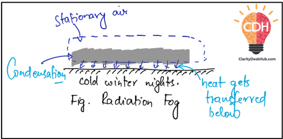
Definition: Radiation Fog is a fog formed due to radiative cooling of warm, moist air lying over a cold ground surface, typically occurring on long, cool winter nights with weak air motion.
✅ Conditions needed for radiation fog:
- Long, cool nights (common in winters)
- Clear sky (so heat escapes easily)
- High moisture content in the air
- Very weak wind movement
- A layer of cool air near the ground (temperature inversion)
This type of fog is common in valleys and low-lying areas, especially during winter mornings.
2. Advectional Radiation Fog
Now, let’s travel to a coastal region. Here, the air is on the move—warm, moist air from the ocean drifts inland over a much colder surface, such as land during winter. The sudden cooling triggers condensation, forming fog.
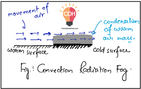
Definition: Advectional Radiation Fog is a fog developed when warm, moist air moves horizontally over a colder surface, leading to condensation due to temperature contrast, commonly seen in winter on land and summer over seas.
✅ Conditions required:
- Horizontal air movement (advection)
- A strong temperature contrast between the air and the ground
- Moist air from a warmer region moving over a cooler surface
📍 Real-world example:
- The dense fog off the coast of Newfoundland, where the warm Gulf Stream meets the cold Labrador Current.
- Foggy conditions near Japan’s coastline, where the cold Oyashio Current meets the warm Kuroshio Current.
3. Steam Fog
Picture a cold morning near a lake. You notice steam-like wisps rising from the water’s surface. This is steam fog—formed when cold air moves over a warm water body. The warmth of the water causes rapid evaporation, and when this moisture-laden air rises and meets the cold air above, it cools and condenses into fog.
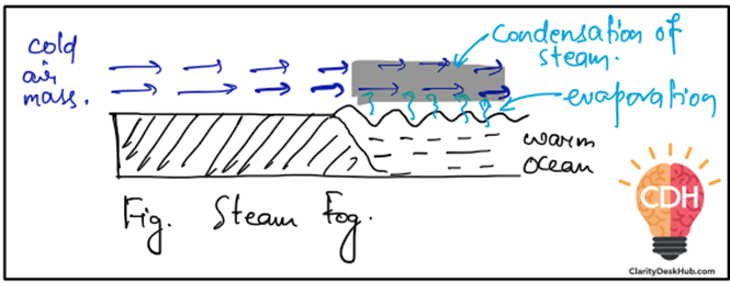
Definition: Steam Fog is created when cold air moves over a warmer water surface, causing evaporation, followed by condensation upon meeting the cold air above, giving a steaming appearance.
✅ Where does this happen?
- Over lakes and oceans in winter
- Common in high-latitude regions, where cold winds blow over warmer waters
4. Upslope Fog
Imagine driving up a mountain road and suddenly entering a cloud-like mist that wasn’t there at the base. This is upslope fog, formed when moist air is pushed uphill by wind. As the air rises, it expands and cools (adiabatic cooling), reaching saturation and forming fog along the slopes.
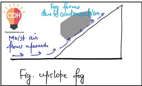
Definition: Upslope Fog occurs when warm, moist air rises along a slope, undergoes adiabatic cooling, and condenses to form fog covering hillslopes, commonly seen in temperate regions.
✅ Where does it occur?
- Mountainous and hilly regions
- Common in temperate regions where moist winds blow against hillsides
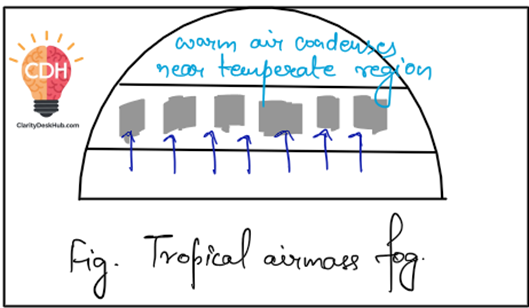
5. Tropical Airmass Fog
Now, let’s sail into the middle latitudes of the ocean. Here, warm, moisture-laden tropical air moves poleward. As it encounters colder regions, it gradually cools, and fog forms over the sea. This type of fog often comes with mist and drizzle.
Definition: Tropical Airmass Fog forms over mid-latitude seas when warm, tropical air moves poleward and cools in transit, often accompanied by mist and drizzle, common in regions like the Gulf of Alaska.
📍 Common locations:
- Gulf of Alaska
- Aleutian Islands
6. Frontal Fog
Finally, let’s visit a stormy region where warm and cold air masses clash—like a battlefield. When a warm, moisture-filled air mass meets a cold front, the heavier cold air pushes the warm air upward. The warm air cools as it rises, and its moisture condenses into fog. This type of fog is common in temperate cyclone zones.
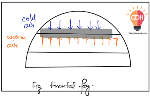
Definition: Frontal Fog develops along warm and cold fronts of temperate cyclones due to the cooling of warm, moist air by the underlying cold air, leading to condensation and fog formation.
✅ Where does it occur?
- Along warm and cold fronts in temperate regions
Final Thoughts
Fog is nature’s way of playing with moisture and temperature, painting landscapes with an air of mystery. Whether it’s the rolling mist of a winter field, the eerie fog on a mountain road, or the thick veil covering the ocean, every type of fog has a story to tell—shaped by the dance of warm and cold air.