
Clouds

If you are looking up at the sky on a bright afternoon—you see puffy cotton-like shapes drifting lazily, sometimes turning into dark, ominous masses before a storm. These are clouds, nature’s way of storing and transporting water across the globe. But how exactly do these fascinating formations come into existence? Let’s explore in detail:
What Are Clouds?
Clouds are massive collections of tiny water droplets or ice crystals suspended in the air. They form when water vapour—the invisible gaseous form of water—condenses into liquid or ice. This process happens high above the ground, where the temperature and air pressure conditions allow it.
How Do Clouds Form?
There’s always moisture in the air in the form of water vapour, though we don’t see it. However, for clouds to form, this water vapour must condense into visible droplets. This process requires two key elements:
- Aerosols (Condensation Nuclei):
- These are tiny particles like dust, salt, or smoke floating in the air.
- Water vapour sticks to these particles, allowing condensation to begin.
- Cooling of Air:
- As warm air rises, it expands and cools due to decreasing atmospheric pressure.
- Cooler air can’t hold as much moisture, so condensation occurs, forming tiny droplets that cluster together to form clouds.
🔹 The altitude where condensation begins and clouds start forming is called the Condensation Level.
When Does Air Become Saturated?
For clouds to form, the air must reach a point where it cannot hold more moisture. This can happen in two ways:
- Increased Moisture Content:
- When more water evaporates into the air, increasing humidity until it reaches saturation.
- Cooling to Dew Point:
- If warm air cools down to its dew point (the temperature at which condensation occurs), clouds will form.
💡 Fun Fact: Warmer air holds more moisture, which is why humid summer days feel sticky, while cold winter air feels dry.
Cloudburst
Now, let’s talk about an extreme weather event—cloudbursts.
Imagine a thundercloud high in the sky. Raindrops form inside it and begin to fall, but suddenly, a powerful updraft (warm air rising from the ground) pushes them back up. More and more raindrops accumulate inside the cloud, increasing in size and weight.
At some point, the cloud can no longer hold this excessive moisture, and the air currents weaken. The result? A violent downpour of rain within a very short span of time.
Characteristics of a Cloudburst:
- Defined as more than 100 mm of rainfall within an hour over a small area.
- The rain does not fall gradually but bursts out suddenly.
- Can dump 70,000 tonnes of water over just one acre!
- Common in mountainous regions, especially in India, where monsoon clouds are trapped by tall peaks.
🔹 Why are cloudbursts dangerous?
Because of their sudden and intense nature, they can lead to flash floods, landslides, and destruction—especially in hilly terrains.
Types of Clouds
Let’s say you are on a journey, soaring through the sky in a hot air balloon. As you ascend, you see different types of clouds—some floating high like delicate wisps, others standing tall like cotton castles, and some so dark and dense that they seem to carry a storm within. Clouds are not just fluffy decorations in the sky; they tell stories about the weather and help us predict what’s coming.
Now, let’s categorize them based on their height, shape, density, and transparency. Scientists classify clouds into four major types:
- Cirrus – High, wispy clouds that resemble feathers.
- Cumulus – Puffy, cotton-like clouds.
- Stratus – Layered clouds covering vast areas.
- Nimbus – Dark, rain-bearing clouds.
These four types mix and evolve into several variations, each with its unique characteristics. Let’s take a closer look at each one.
1. Cirrus Clouds
🔹 Altitude: 8,000-12,000 m
🔹 Appearance: Thin, feathery, and always white
🔹 Made of: Ice crystals
🔹 Weather Indication: Dry weather, no rainfall
These clouds look like delicate brushstrokes across a blue canvas. If you see them, it means the weather will remain dry. However, their presence might indicate an approaching weather change, as they often precede storms by a day or two.
2. Cumulus Clouds
🔹 Altitude: 4,000-7,000 m
🔹 Appearance: Large, fluffy, and white with a flat base
🔹 Weather Indication: Usually fair weather, but can develop into storm clouds
These are the classic “cartoon clouds” that we all drew as kids—big and fluffy. On a sunny day, they drift lazily across the sky, but when they grow taller, they can turn into cumulonimbus clouds, which bring thunderstorms.
3. Stratus Clouds
🔹 Appearance: Uniform, grayish layers covering the sky
🔹 Formation: Due to cooling air or the mixing of warm and cold air masses
🔹 Weather Indication: Light drizzle or overcast conditions
Stratus clouds are like a dull, grey bedsheet spread across the sky, blocking the sun. They rarely bring heavy rain but often result in a persistent drizzle.
4. Nimbus Clouds
🔹 Appearance: Thick, dark gray clouds
🔹 Weather Indication: Heavy rain, snow, or storms
Nimbus clouds are dense and heavy, often appearing before a downpour. When you see a nimbostratus cloud, expect long-duration rainfall. If you spot cumulonimbus, get ready for thunderstorms, lightning, and gusty winds!
Types of clouds (Wikimedia Commons)
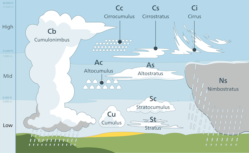
Clouds by Altitude and Development
Beyond these basic types, clouds are further classified based on their altitude and how they evolve.
🌤 High Clouds (Above 6,000 m)
- Cirrus (Ci): Fibrous or silky appearance, transparent and white in colour; indicate dry weather.
- Cirrostratus (Cs): Thin, milky veil covering the sky; often forms halos around the sun or moon.
- Cirrocumulus (Cc): Small, rippling clouds like fish scales; common in deserts.
⛅ Middle Clouds (2,000-6,000 m)
- Altostratus (As): thin sheets of grayish-blue layers having fibrous or uniform appearance, widespread drizzle or light snow.
- Altocumulus (Ac): Woolly, white or gray clouds in wavy layers; bring light drizzle.
☁️ Low Clouds (Below 2,000 m)
- Stratocumulus (Sc): Rounded patches of white or gray; associated with fair weather or light drizzle.
- Nimbostratus (Ns): Dark, thick layers causing steady rain or snow.
⛈️ Clouds with Vertical Growth
- Cumulus (Cu): White, dome-shaped clouds with a flat base; fair weather.
- Cumulonimbus (Cb): Massive storm clouds; bring heavy rain, lightning, and hailstorms.


