
Waters of Europe: Understanding the Flow of Rivers and Lakes

Major Rivers of Europe
Rivers in Europe were primarily formed due to tectonic uplift, glacial activity, and consistent climatic influences. Mountain ranges like the Alps and Carpathians emerged from the collision of tectonic plates, giving rise to rivers as rain and melting snow flowed downhill. During the Ice Ages, glaciers carved valleys and, upon melting, released vast amounts of freshwater that shaped or fed many rivers. Over time, erosion, river capture, and rainfall patterns helped define Europe’s major river systems such as the Danube, Rhine, and Volga.
Before we dive in, here’s a guiding principle:
“A river is not just a water channel—it’s a flow of civilisation, economy, culture, and political geography.”
In World Mapping, rivers are not just physical features—they are economic lifelines, cultural boundaries, and often international issues.
1. 🌊 Volga River (3,690 km)
- Origin: Valdai Hills, Russia
- Mouth: Caspian Sea
- Superlatives:
- Longest river in Europe
- Economically the most important for Russia
- Tributaries: Oka, Kama
- Country: Entirely in Russia
📝 Significance:
It’s the Ganga of Russia in terms of cultural and economic significance—used for irrigation, navigation, and hydroelectricity.
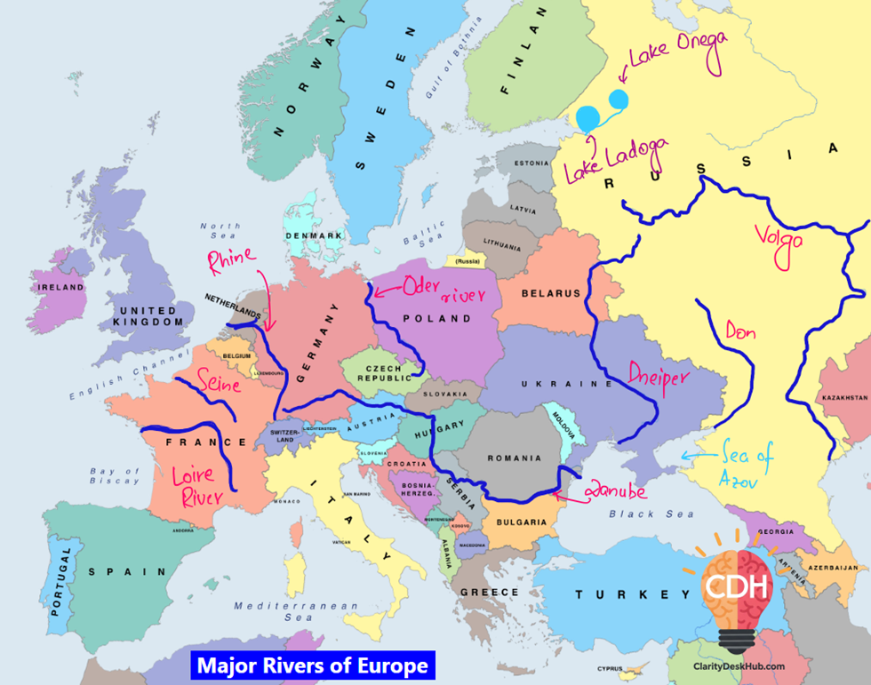
2. 🌊 Danube River (2,860 km)
- Origin: Black Forest, Germany
- Mouth: Danube Delta into the Black Sea
- Superlatives:
- Second-longest river in Europe
- Passes through 10 countries (only the Nile flows through more!)
- Countries: Germany, Austria, Slovakia, Hungary, Croatia, Serbia, Romania, Bulgaria, Moldova, Ukraine
- Cities: Vienna, Bratislava, Budapest, Belgrade
- Connected to North Sea via: Rhine–Main–Danube Canal
📝 Significance:
It’s a truly international river—a living example of Europe’s integration. Acts as both trade route and cultural bridge.
3. 🌊 Ural River (2,428 km)
- Origin: Ural Mountains
- Mouth: Caspian Sea (Kazakhstan)
- Countries: Russia and Kazakhstan
📝 Significance:
Important for defining the continental boundary between Europe and Asia (along with the Ural Mountains).
4. 🌊 Dnieper River (2,290 km)
- Origin: Valdai Hills, Russia
- Mouth: Black Sea (Dnieper Delta, Ukraine)
- Countries: Russia, Belarus, Ukraine
- Superlative: Longest river of Ukraine and Belarus
- Usage: Major navigable waterway for Ukraine
📝 Significance:
Vital to Ukraine’s economy, agriculture, and hydroelectric power.
5. 🌊 Don River (1,950 km)
- Origin: Central Russian Upland
- Mouth: Sea of Azov
- Country: Russia
- Importance:
- Second major river of western Russia
- Widely navigable; supports inland trade
6. 🌊 Rhine River (1,236 km)
- Origin: Swiss Alps
- Mouth: North Sea (Netherlands)
- Countries: Switzerland, Germany, France, Netherlands
- Industrial Importance:
- Flows through Europe’s industrial heartland
- Connected with Danube via Rhine–Main–Danube Canal
📝 Significance:
Considered the economic backbone of Western Europe, especially for Germany and Netherlands.
Tectonic Drama: How the Rhine Carved Its Path

The Upper Rhine River flows through a rift valley, known as the Upper Rhine Graben, which is a classic example of tectonic rifting in Europe. This rift formed due to the divergent movement of two tectonic blocks—one associated with the Vosges Mountains in France and the other with the Black Forest (Schwarzwald) in Germany.
As these landmasses pulled apart millions of years ago, the central land between them subsided, creating a low-lying graben (rift valley). Over time, this depression was occupied by the Rhine River, which now flows through it, flanked by the raised fault-block mountains on either side.
This region is also tectonically active, with geothermal activity and occasional minor earthquakes, further proving its rift origin.
7. 🌊 Vistula River (1,047 km)
- Origin: Southern Poland
- Mouth: Gdańsk Bay, Baltic Sea
- Country: Entirely in Poland
- Superlative: Poland’s longest river
📝 Significance:
Key for Poland’s trade, transport, and agriculture.
8. 🌊 Loire River (1,012 km)
- Origin: Massif Central, France
- Mouth: Bay of Biscay, Atlantic Ocean
- Superlative: Longest river of France
📝 Significance:
It flows through the Loire Valley, a UNESCO World Heritage Site famous for vineyards and castles.
9. 🌊 Oder River (854 km)
- Origin: Olešnice town, Czech Republic
- Mouth: Szczecin Lagoon → Baltic Sea
- Countries: Czech Republic, Poland, Germany
- Geopolitical Role:
➤ Forms part of the Poland–Germany border
📝 Significance:
Strategic for East-Central Europe’s trade.
10. 🌊 Rhone River (815 km)
- Origin: Rhône Glacier, Swiss Alps
- Mouth: Mediterranean Sea
- Countries: Switzerland, France
📝 Significance:
One of the few major rivers that directly drain into the Mediterranean—important for southern France.
11. 🌊 Seine River
- Origin: Langres Plateau, France
- Mouth: English Channel, Northern France
- Importance:
- Passes through Paris
- France’s second-longest river
- River basin made of permeable rocks—helps in flood control
📝 Significance:
Culturally iconic—featured in art, literature, and critical to Parisian urban planning.
12. 🌊 Elbe River
- Origin: Border of Czech Republic and Poland
- Mouth: North Sea (Germany)
- Countries: Czech Republic, Germany
- Utility:
- Long-used for navigation and hydropower
📝 Significance:
Connects Central Europe to the North Sea—key for exports.
🔄 Summary Table: Major Rivers of Europe
| River | Length (km) | Origin | Mouth | Countries | Key Fact |
| Volga | 3,690 | Valdai Hills | Caspian Sea | Russia | Longest in Europe |
| Danube | 2,860 | Black Forest | Black Sea | 10 countries | 2nd longest, international river |
| Ural | 2,428 | Ural Mountains | Caspian Sea | Russia, Kazakhstan | Europe–Asia boundary river |
| Dnieper | 2,290 | Valdai Hills | Black Sea | Russia, Belarus, Ukraine | Longest in Ukraine |
| Don | 1,950 | Central Russian Upland | Sea of Azov | Russia | Major inland waterway |
| Rhine | 1,236 | Switzerland | North Sea | 4 countries | Economic artery of Western Europe |
| Vistula | 1,047 | Poland | Baltic Sea | Poland | Longest in Poland |
| Loire | 1,012 | France | Bay of Biscay | France | Longest in France |
| Oder | 854 | Czech Republic | Baltic Sea | Czech R., Poland, Germany | Forms Poland–Germany border |
| Rhone | 815 | Swiss Alps | Mediterranean | Switzerland, France | Flows into Mediterranean |
| Seine | ~775 | Langres Plateau | English Channel | France | Runs through Paris |
| Elbe | ~727 | Czech border | North Sea | Czech R., Germany | Historic transport route |
🧠 Things to focus:
- Focus on rivers that cross multiple countries—like Danube, Rhine, Oder.
- Remember origin–mouth pairs—can be asked in matching-type questions.
- Learn economic uses: navigation, hydroelectricity, agriculture.
- Rivers like the Danube and Rhine are especially important in international relations, transportation corridors, and EU integration.
🚢 Major Inland Waterways of Europe
Inland waterways are Europe’s arteries of trade and integration, allowing efficient movement of goods, linking landlocked nations to global seas, and connecting natural and man-made river systems.
1. 🌊 Volga–Baltic Waterway (formerly Mariinsk Canal System)
- Connects: Volga River ↔ Baltic Sea (via Lake Onega & Lake Ladoga)
- Indirectly links: Caspian Sea ↔ Atlantic Ocean
- Location: Northwestern Russia
- Importance:
- Enables Russian exports to reach Western Europe
- Uses a system of canals and lakes
🧭 Think of it as Russia’s inland bridge from Caspian to the Baltic.
2. 🌊 Volga–Don Shipping Canal
- Connects: Volga River ↔ Don River
- Mouths: Caspian Sea ↔ Sea of Azov (→ Black Sea → Mediterranean → World Oceans)
- Significance:
- Shortest navigable link from Caspian Sea to the World Ocean
- Vital for Russia’s southern trade
🧭 Strategic in geopolitics—Caspian to global shipping.
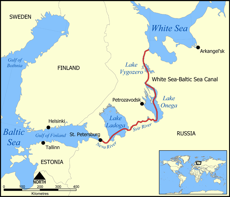
3. 🌊 White Sea–Baltic Canal
- Connects: White Sea ↔ Lake Onega ↔ Volga–Baltic Waterway
- Built by: Soviet Union (1930s)
- Strategic Use:
- Northern Russia’s military and trade navigation
- Harsh climate limits usage seasonally
🧭 Links Arctic Ocean (White Sea) to the Baltic—Arctic naval movement.
4. 🌊 Main–Danube Canal
- Connects: Main River (Rhine basin) ↔ Danube River
- Completed in: 1992
- Importance:
- Creates a continuous waterway from North Sea to Black Sea
- Links Western and Eastern Europe
- Boosts inland shipping across Germany, Austria, and Balkans
🧭 Symbol of European integration—Atlantic to Black Sea, end-to-end trade corridor.
5. 🌊 Rhone–Rhine Canal
- Connects: Rhine River (Basel) ↔ Saône River (Rhône basin)
- Links: North Sea ↔ Mediterranean Sea
- Importance:
- Trade between France and Germany
- Declining commercial use, but still strategic
🧭 North-South route: Industrial Rhine to wine-growing Rhône.
6. 🌊 Amsterdam–Rhine Canal
- Connects: Port of Amsterdam ↔ Rhine River
- Helps in: Linking Dutch ports with Germany’s Ruhr industrial region
- Usage: High-volume shipping route
🧭 Gateway from North Sea to central European industry.
7. 🌊 Marne–Rhine Waterway
- Connects: Paris Basin ↔ Alsace–Lorraine industrial region
- Use: Internal French trade and transport
- Link: Eastern and western France
🧭 Internal logistics channel of France—Paris to eastern frontier.
🧊 Major Lakes of Europe
1. 🏞️ Lake Ladoga
- Location: Northwestern Russia
- Superlative: Largest lake in Europe
- Connected with:
- Volga–Baltic Waterway
- Lake Onega
- Navigability: Yes
- Usage: Trade, hydroelectricity, and water transport
🧭 Hydrological hub of Russia’s northwest.
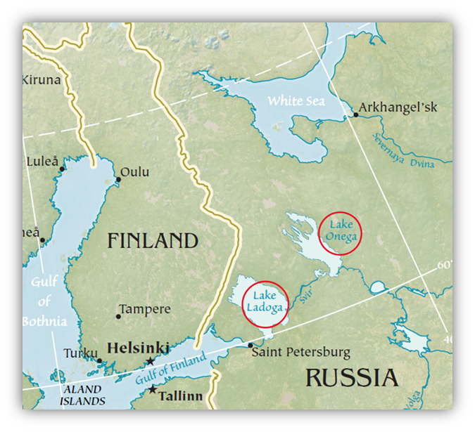
2. 🏞️ Lake Onega
- Location: Also in Northwestern Russia
- Superlative: Second-largest lake in Europe
- Connects:
- White Sea (via White Sea–Baltic Canal)
- Lake Ladoga
- Usage: Navigation and strategic transport
🧭 The “bridge lake” between Baltic and Arctic via canals.
🧠 Smart Revision Table:
| Feature | Connects | Significance |
| Volga–Baltic Waterway | Volga ↔ Baltic Sea | Links Caspian to Atlantic |
| Volga–Don Canal | Volga ↔ Don | Caspian ↔ World Ocean (via Black Sea) |
| White Sea–Baltic Canal | White Sea ↔ Lake Onega | Arctic ↔ Baltic route |
| Main–Danube Canal | Rhine (Main) ↔ Danube | Atlantic ↔ Black Sea |
| Rhone–Rhine Canal | Rhine ↔ Rhône | North Sea ↔ Mediterranean |
| Amsterdam–Rhine Canal | Amsterdam ↔ Rhine | Netherlands ↔ Ruhr industry |
| Marne–Rhine Waterway | Paris ↔ Alsace-Lorraine | Internal France trade |
| Lake Ladoga | In Russia | Largest lake, part of waterway system |
| Lake Onega | In Russia | 2nd largest, links White Sea to Baltic |
🧠 Memory Insights:
- Focus on canals that connect river basins (e.g. Main–Danube, Volga–Don).
- Learn which seas are being connected—Atlantic, Mediterranean, Caspian, Arctic, Baltic.
- Volga–Don Canal and Main–Danube Canal are most often asked.
- Lakes Ladoga and Onega are map favourites—both in Russia, both part of navigation systems.


