
William Morris Davis & His Concept of Landscape Development
William Morris Davis, the father of geomorphology, introduced a fascinating theory—the Geographical Cycle of Erosion, also called the Cycle of Erosion.
According to Davis landforms undergo sequential changes through time (passing through three stages of youth, mature and old).
- The earth’s surface is affected by two types of forces i.e. Endogenetic forces and exogenetic forces.
- Endogenetic forces create vertical irregularities on the earth’s surface by forming several types of relief features whereas
- Exogenetic forces such as wind, rivers, glaciers etc. try to remove the vertical irregularities and ultimately become successful in bringing down the reliefs to low featureless plain, called as a peneplain.
Over time, the battle between these two forces leads to a systematic transformation of landforms through three distinct stages—Youth, Maturity, and Old Age—just like a human life cycle!
The Three Pillars of Davis’ Model
According to Davis three factors i.e. structure, process and time play important roles in the origin & development of landforms of a particular place where,
- structure means lithological and Structural characteristics of rocks.
- Time was not only used in temporal context by Davis but it was also used as a process itself.
- Process means an agent of denudation including both weathering & erosion.
Assumption of Davisian Model:
The basic premises of Davisian model of ‘geographical cycle’ included assumptions —
- Landforms are the evolved products of the interactions of endogenetic forces originating from within the earth & the exogenetic forces such as winds, rivers, glaciers etc. originating from the atmosphere.
- The evolution of landforms takes place in an orderly manner in such a way that a systematic sequence of landforms is developed through time.
- Streams erode their valleys rapidly downward until the graded condition is achieved.
- There is a short period rapid rate of upliftment in landmass.
- Erosion does not start until the upliftment is complete.
Therefore first Endogenetic forces come into play and after that exogenetic forces.
The Three Stages of Landscape Evolution
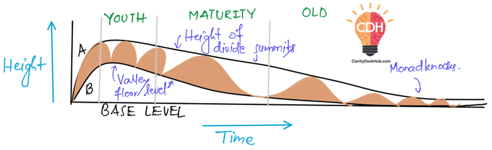
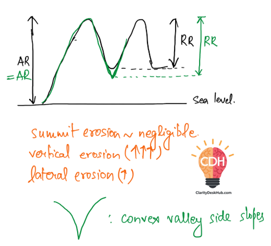
Youthful Stage
Think of this stage as a fresh, newly uplifted landmass, full of energy but not yet sculpted by erosion. Imagine a rough, untouched terrain where rivers are just starting to carve their paths.
- Since the land has just been uplifted, erosion is in its infancy. The highest parts (summits) of the landscape remain untouched because the rivers are too small and too far apart to reach them.
- The rivers, though small, are ambitious. They work hard, extending their lengths through headward erosion—meaning they erode backward toward their source, trying to stretch as far as possible.
- The rivers flow rapidly down steep slopes, cutting deep into the ground through vertical erosion. As a result, valleys start forming, but they are narrow, deep, and shaped like a “V” because the river mainly cuts downward rather than sideways. So, basically, Valleys are of V shape characterized by convex valley side slopes
- The difference between the highest point (summits) and the deepest valleys (relative relief) keeps increasing, though the absolute height of the landscape remains unchanged.
- If you could fly over this stage, you’d see a rugged landscape with deep, V-shaped valleys separated by high, untouched ridges.
- The lower curve (B) falls rapidly because of valley deepening but the upper curve (A) remains almost parallel to the horizontal axis because summits are not affected because of erosion, thus absolute relief remains constant & relative relief continues to increase till the end of youthful stage.
Note: Absolute Relief never increases in Davis Theory in any stage
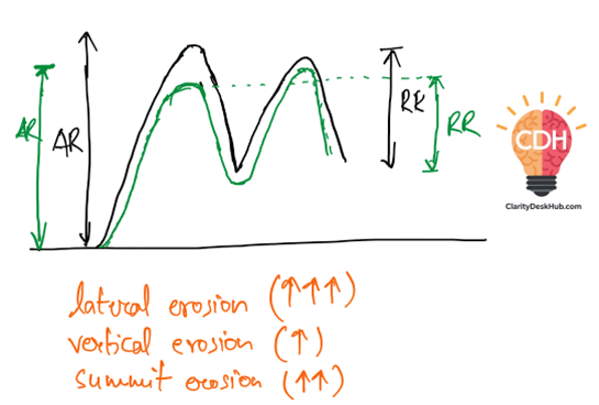
Mature Stage
Now, imagine the land has aged a little—it’s not as wild and extreme as in its youth. The rivers have grown larger and more organized, forming a well-connected drainage system.
- The rivers, now stronger and more stable, shift their focus from cutting downward (vertical erosion) to cutting sideways (lateral erosion).
- This sideways cutting makes valleys broader, transforming the sharp V-shape of the youthful stage into a more gentle U-shape.
- The once untouched summits of the water divides are now getting eroded, lowering the overall elevation.
- The absolute and relative relief (the height difference between peaks and valleys) both start to decrease.
- By the end of this stage, the landscape is well-integrated with smoothly flowing rivers and widening valleys
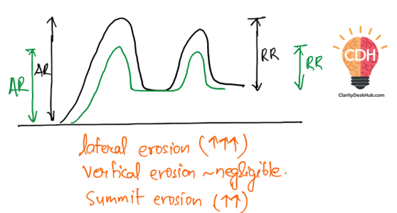
Old stage
At this point, the landscape has become old and mature—just like an experienced elder who has settled into a peaceful life😀. The rivers no longer cut deep into the land but instead focus on expanding the landscape sideways.
- There is almost no more vertical erosion—the rivers have lost their aggressive cutting power. Instead, they continue their lateral erosion, widening valleys even more.
- The highlands and divides keep eroding down, making the entire landscape much flatter.
- The valleys are now broad and flat, with gentle concave slopes instead of sharp, rugged edges.
- The landscape is dominated by large floodplains, meandering rivers, and occasional isolated hills (called monadnocks), which are the last remnants of the once towering peaks.
- Eventually, the entire land flattens into a peneplain—a nearly level surface with minimal elevation differences.
Absolute Relief (AR) and Relative Relief (RR) in Davis’ Cycle of Erosion
Absolute Relief (AR):
- Absolute relief refers to the total elevation of a landmass above sea level.
- It indicates the maximum height of the landscape, typically measured from the highest summit to the base level (sea level).
- In Davis’ model, absolute relief never increases; it either remains constant (in the youthful stage) or decreases (in maturity and old age) due to erosion.
Relative Relief (RR):
- Relative relief is the difference in elevation between the highest and lowest points of a given area (e.g., the height difference between summits and valley floors).
- It indicates how rugged or uneven the terrain is.
- In Davis’ model, relative relief increases in the youthful stage (as valleys deepen) and decreases in the mature and old stages (as lateral erosion reduces elevation differences).
| AR | RR | Valley shape | |
|---|---|---|---|
| Young Stage | Constant | Increases | V-Shape |
| Mature Stage | Decrease | Decrease | U-Shape |
| Old Stage | Decrease | Decrease | — |
Concept of Headward Erosion
Imagine a river or stream flowing downhill. Naturally, you’d think it’s eating into the land and cutting deeper as it flows forward. That’s vertical erosion. But rivers don’t just deepen their valleys; they also grow backward. This backward growth of a river’s source, or the upstream extension of the valley, is what we call:
🔍 Headward Erosion:
It is the erosion that occurs at the origin (head) of a stream, causing it to migrate in the direction opposite to the flow of water—that is, upstream.
Now let’s understand this clearly, since you are at claritydeskhub.com 😉
🎯 Why Does Headward Erosion Happen?
This happens when water flowing through a channel erodes the land at its source or head. The reasons could be:
- Difference in elevation (higher gradient) — water from a steeper slope gains energy to cut into the land.
- Unequal water discharge between neighboring streams — a stronger stream can encroach into the territory of a weaker one (this is crucial in river capture or stream piracy).
- Soil or rock softness — weaker materials are eroded faster, allowing the stream to extend its course upstream.
📈 Mechanism: How Exactly Does Headward Erosion Work?
Let’s visualize the process in steps:
- Waterfalls and Rapids: At the river’s head, if there’s a waterfall or steep gradient, erosion is intense. The falling water hits the base, undermines the cliff, and causes headward retreat of the waterfall.
- Gullies and Rills: In early stages of drainage formation, tiny rills (small channels) join to form gullies, and erosion at the head of these gullies causes them to extend further towards the upland.
- Weathering + Mass Wasting: The head of the valley is weakened by weathering, and gravity pulls loosened material downhill—helping the stream push its origin backward.
🧠 Analogy: A Real-Life Example to Grasp It Better
Picture a saw gradually cutting a plank of wood from the edge. As you move the saw back and forth, the cut moves deeper, but also inward from the edge—eating back the wood toward the handle. Similarly, a stream not only deepens but also shifts its head backward over time. That backward cutting is headward erosion.
You can watch this beautiful short 🎥video which explains headward erosion and the waterfall formation.
🧭 Importance in Geomorphology
- Stream Capture (River Piracy): When a river grows through headward erosion and intercepts another stream, capturing its flow—it results in river piracy. This explains shifts in river courses over geological timescales.
- Drainage Evolution: The development and integration of drainage networks (from rills → gullies → streams → rivers) largely depends on headward erosion.
- Landscape Modification: Valleys become elongated and expanded as streams grow upstream. This plays a vital role in valley development, formation of canyons, and rejuvenation stages in river cycles.
🌍 Where Do We Observe Headward Erosion?
- In youthful rivers as explained in this section like the upper courses of the Himalayan rivers (e.g., Alaknanda, Mandakini).
- At waterfalls like the Niagara Falls, where the falls are retreating upstream due to continuous erosion.
- In arid or semi-arid regions, where rain-fed streams rapidly deepen and lengthen during flash floods.
Evaluation of Davis’ Theory: Strengths & Weaknesses
William Morris Davis’ Cycle of Erosion was one of the earliest and most influential theories in geomorphology. However, like any scientific model, it has its strengths and limitations. Let’s analyze both sides one by one:
Pros: Why Davis’ Theory Was Revolutionary
- Simplicity & Applicability – The theory provided a simple and structured explanation of how landscapes evolve over time. It was easy to understand and widely applicable.
- Empirical Basis – Unlike purely theoretical models, Davis’ concept was based on extensive field observations, making it an empirical study rooted in real-world examples.
- Predictive & Historical Relevance – The model not only helped in interpreting past landform evolution but also had the potential to predict future changes, making it a useful tool for geographers.
- Synthesis of Evolutionary Ideas –
- Davis successfully combined Charles Darwin’s theory of biological evolution (young → mature → old) with James Hutton’s uniformitarianism (geological changes happen gradually over time).
- Just like species evolve through different life stages, Davis’ landforms also followed a similar progression.
Cons: The Limitations of Davis’ Model
While Davis’ model was groundbreaking, modern geomorphologists have identified several flaws:
1. Unrealistic Assumption of Rapid Upliftment
- Davis assumed that upliftment happens quickly over a short period, followed by a long, stable period of erosion.
- However, plate tectonics (discovered later) proved that upliftment is actually slow and continuous, rather than sudden.
2. Overemphasis on Rivers & Erosion
- His model focused only on fluvial (river) processes and neglected other important erosional agents like glaciers, wind, and coastal processes.
- This oversimplification led to criticisms that his model was too narrow and incomplete.
3. The ‘Time’ Factor Dominated Over ‘Structure & Process’
- Davis identified structure, process, and time as key factors shaping landscapes, but in practice, his model gave too much importance to time (cyclical stages).
- This created a stage-based framework, which ignored the complex and simultaneous action of multiple processes.
4. Ignoring Continuous Tectonic Activity
- The model assumes that erosion starts only after upliftment is complete.
- However, modern science shows that erosion and upliftment happen simultaneously—as soon as land starts rising, erosion begins.
- Davis’ model also assumes long tectonically stable periods, which is unrealistic because earthquakes, faults, and crustal movements constantly shape landscapes.
5. Forced Expansion to Other Erosional Agents
- Davis later introduced Glacial and Marine Cycles of Erosion under pressure from critics.
- However, he called them “climatic accidents”, implying that fluvial erosion was the norm, and other processes were just exceptions.
- This weakened the universality of his model, as landscapes are typically shaped by multiple processes acting together (polygenetic nature) rather than a single agent.
6. Lack of Acknowledgment for Endogenetic Forces
- While Davis recognized upliftment as a starting point, his model did not account for the continuous role of internal (endogenetic) forces like volcanism, faulting, and folding.
- Landscapes are shaped not just by erosion but also by forces from within the Earth.
Peneplain
If Davis’ landscape evolution is a three-act play—youth, maturity, and old age—then the peneplain is the curtain call. After the land has passed through the energetic youthful stage with sharp relief and vertical erosion, and the mature stage marked by well-developed valleys and lateral erosion, it enters its final, senile phase. Here, erosion acts not to deepen or widen, but to smooth and level, working relentlessly to reduce all irregularities of the terrain.
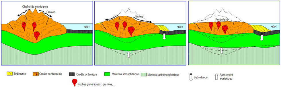
By Virginie Marquet CC BY-SA 3.0; via Wikimedia Commons
This leads to the formation of a peneplain—a nearly featureless, gently undulating plain where the forces of denudation have stripped the land of its dramatic features. While true peneplanation is more theoretical than real, it represents the ideal end-point in Davis’s model, where the entire landscape is worn down to near base level, interrupted only by isolated remnants like monadnocks.
In Davis’s own words, the peneplain is the “end product of normal erosion under conditions of uniform structure, climate, and base level over a long geological time.”
Key Features of a Peneplain
- The Final Stage of Erosion
- In the last stages of a landscape’s evolution, deep valleys stop forming. Instead, rivers begin to erode sideways (lateral erosion) rather than downward, cutting into the surrounding land.
- The result? Interstream areas (regions between rivers) shrink as erosion smooths out the rough edges of the terrain.
- The Vanishing Act of Water Divides
- Water divides—those ridges that separate river valleys—become lower and lower until they are barely noticeable.
- Valleys lose their depth and adopt a flatter, concave shape, making the land appear more uniform.
- A Land Without Sharp Features
- Eventually, the land becomes so eroded that absolute relief (height differences between peaks and valleys) is greatly reduced.
- The rivers, now at their base level (the lowest point they can erode to), become slow and meandering, no longer powerful enough to carve deep gorges.
- The Rise of Monadnocks: Last Survivors of a Once-Mighty Landscape
- Even in the most level peneplain, some isolated hills remain, refusing to be eroded completely.
- Davis called these leftover landforms Monadnocks, named after Mt. Monadnock in New Hampshire, USA.
- These are like wise old sages of the landscape, standing tall amidst the flattened land, telling the story of a terrain that once was.
- A Landscape That Never Reaches Perfection
- Davis himself acknowledged that a true peneplain—where the land is perfectly level—doesn’t really exist.
- The process of erosion never fully erases a landmass, nor does the Earth remain still for long enough to complete this transformation.
Types of Peneplain
Not all peneplains are created equal. Some are still forming, some have merged, and others have been lifted up again by tectonic forces. Let’s look at the different types:
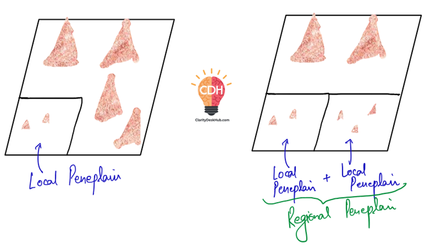
- Local Peneplain – A small section of land that has undergone peneplanation while the rest of the region is still eroding. Think of this as a few students finishing an exam while the rest of the class is still writing 😊
- Regional Peneplain – When multiple local peneplains merge together, forming an almost continuous featureless plain over a vast area.
- Uplifted Peneplain – The story doesn’t always end in a quiet, level plain. Sometimes, tectonic forces push up an already flattened peneplain, giving it a new lease of life.
- Example: The Appalachian Mountains in the USA have three uplifted peneplains:
- Schooling Peneplain
- Harrisburg Peneplain
- Sommerville Peneplain
- Example: The Appalachian Mountains in the USA have three uplifted peneplains:
- Resurrected Peneplain – Imagine a peneplain getting buried under sediments or submerged under the sea. Later, due to erosion or tectonic uplift, it is exposed again.
- These are called “resurrected” because they are like ancient ruins being uncovered after centuries.
Criticism of the Peneplain Concept
While Davis’ peneplain model was revolutionary, later scientists pointed out several flaws:
- Peneplains are rare in reality – If Davis’ model was universal, we should see more fully developed peneplains, but very few places fit his description.
- Most remnants of peneplains are incomplete – Many supposed peneplains are found in fragments, suggesting other processes shaped them.
- No landscape reaches a perfect base level – Even where land is heavily eroded, some height variations always remain.
- Earth is always changing – Tectonic movements, climate variations, and erosion never let a landform stay undisturbed long enough for a perfect peneplain to form.
SAMPLE QUESTION
Q. What do you understand by downwasting and backwasting? Explain their role in landscape evolution and identify which process is responsible for the formation of a peneplain. (150 words)
ANSWER:
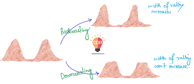
Downwasting and Backwasting
Downwasting refers to the uniform lowering of a landscape due to widespread erosion. It occurs through sheet erosion, deflation (wind erosion), and chemical weathering, gradually reducing the elevation of the land while maintaining relative relief.
Backwasting, on the other hand, involves the lateral retreat of slopes while maintaining their steepness. This occurs due to weathering, landslides, and erosional processes acting on escarpments, mesas, and cliffs.
Role in Landscape Evolution
- Backwasting is common in arid and semi-arid regions, leading to the shrinking of landforms like mesas and buttes.
- Downwasting occurs in humid regions, gradually reducing surface elevation over time.
Formation of Peneplain
Downwasting is responsible for peneplain formation as it uniformly lowers the landscape over an extended period, creating a near-flat surface with minimal relief. This represents the final stage of landscape evolution in humid regions.
Conclusion
While both processes contribute to landscape evolution, downwasting dominates in long-term landform reduction, leading to the development of peneplains.
Slope Decline Theory of W.M. Davis
Imagine you are on a time-lapse journey through a landscape, watching how a newly formed hill slowly transforms over millions of years. This is exactly what W.M. Davis proposed in his Slope Decline Theory, which explains how hillslopes gradually change shape over time through a cyclic process of erosion.
Davis believed that just like landscapes evolve in stages, slopes also undergo a systematic transformation—starting steep and youthful, becoming smoother in maturity, and finally turning into a gentle, concave form in old age.
The Three Stages of Slope Evolution
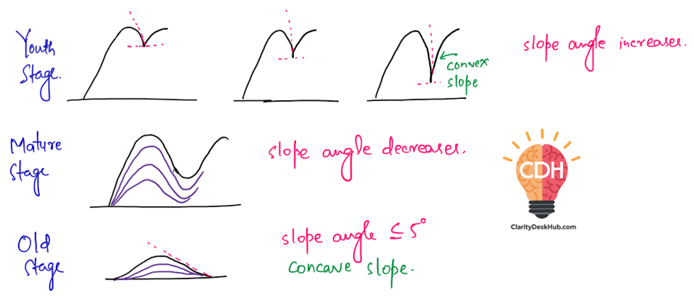
1️⃣ Youthful Stage: Steep & Convex Slopes
🔹 In the beginning, a slope is steep and convex due to active vertical erosion (downcutting) by rivers.
🔹 Weathering starts, but slope retreat is minimal, meaning the steepness either remains the same or increases slightly.
🔹 The landscape is dominated by sharp ridges, deep valleys, and steep hilltops.
💡 Example: Imagine a newly formed valley in a mountainous region, where rivers rapidly carve deep valleys, leaving behind steep slopes.
2️⃣ Mature Stage: Rectilinear Slopes & Slope Decline Begins
🔹 Over time, lateral erosion (side-cutting by rivers) becomes dominant over vertical erosion.
🔹 The sharp ridges of the youthful stage start to wear down, and the slopes begin to decline in steepness.
🔹 The hilltops, or water divides, erode, forming a smoother curve.
🔹 Slopes become more uniform and rectilinear (straight-line appearance).
💡 Example: Look at a hilly region with rolling slopes and valleys that are wider and less steep compared to mountainous areas.
3️⃣ Old Stage: Concave Slopes & Gentle Terrain
🔹 As erosion continues, the slopes decline further and become concave.
🔹 Slope angles become very gentle, often not exceeding 5 degrees.
🔹 The landscape turns into low-lying hills with broad valleys, almost merging with the surrounding plains.
🔹 This stage marks the final flattening of the landscape, often leading to peneplains (almost flat surfaces with few remaining uplands).
💡 Example: The Deccan Plateau in India, where millions of years of erosion have created a gently undulating landscape with few high ridges.
Key Takeaways from Davis’ Theory
✅ Slopes decline progressively over time in a cyclic manner.
✅ The process is controlled by erosion, weathering, and time.
✅ The slope angle reduces from steep (youthful) → moderate (mature) → gentle (old).
✅ The theory explains why old landscapes appear more subdued and less rugged compared to youthful terrains.
However, modern geomorphologists argue that slope evolution is not always so systematic, as climate, geology, and external forces (like tectonic uplift) can disrupt this smooth cycle. But Davis’ theory still remains a foundational concept in geomorphology.
🔹 Think of it like aging—just as humans go through youth, adulthood, and old age, landscapes also evolve through distinct stages over time!
4 Comments