
Overview of Asian Continent
Let us begin with a curious reflection:
How can a continent be both the cradle of civilization and the crucible of modern conflict?
Asia is not just the largest continent in terms of area and population—it is the most contrasted, complex, and contested. It is where the Himalayas pierce the skies, and where the Gobi whispers tales of empires lost in sand. It is the continent of both the oldest recorded cities and the newest tech capitals, of meditating monks and megacities pulsing with innovation.
To study Asia is to hold a map that breathes—where tectonic plates jostle, borders change, and ideas evolve constantly. In this section, we begin mapping Asia not just as a geographical unit but as a civilizational mosaic, with tectonic terrains, cultural clusters, and strategic straits.
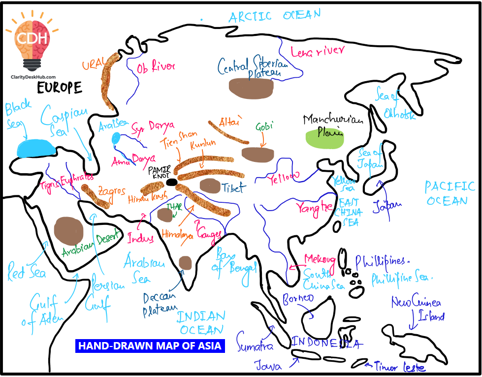
As with our previous approach, we will now sketch an outline map of Asia and mark the key geographical features step by step. I encourage you to do this at least two to three times—this repeated practice will help build muscle memory, making it easier to recall the exact location of each feature during the exam.
🧭 Asia: Where Geography Meets Grand Narratives
Asia is bounded more by nature than by convention:
- To the north, it is hemmed by the Arctic Ocean—frozen yet now geopolitically thawing due to climate change and new trade routes.
- To the east, the Pacific Ocean cradles island nations like Japan and archipelagic giants like Indonesia, while watching over flashpoints like Taiwan and the South China Sea.
- To the south, the Indian Ocean connects Asia to Africa and Australia, serving as a maritime superhighway of global trade since antiquity.
- To the west, it fades into Europe—here, the Ural Mountains and the Caspian Sea often act as boundary markers, but the distinction is cultural, not tectonic.
Asia defies neat divisions. West Asia, Central Asia, South Asia, Southeast Asia, East Asia, and North Asia—each behaves almost like a subcontinent. Their differences are not merely physical, but historical and political.
🏞️ Physiography as Destiny
Asia’s physiography is the blueprint of its civilizations:
- The Himalayas isolate yet inspire. They protected Indian civilization, birthed river systems, and remain a geopolitical flashpoint (India-China border, Tibet issue).
- The Tigris-Euphrates and Indus-Ganga plains saw the rise of the earliest urban settlements—Mesopotamia and the Indus Valley.
- The Loess Plateau and Yangtze basin shaped Chinese civilization, just as the Japanese archipelago mastered nature through harmony and hazard.
- Deserts like the Gobi and Thar act as natural barriers, while plateaus like the Tibetan Plateau influence weather patterns across the continent.
- Volcanic arcs (like the Ring of Fire) and seismic zones shape not just the earth—but also policies, disaster preparedness, and regional cooperation.
🌏 A Cradle of Religions and Revolutions
Asia is where spiritual geography meets political geography:
- Hinduism, Buddhism, Jainism, Sikhism, Islam, Christianity, Judaism—all have roots or branches here.
- It is also the birthplace of major revolutions—Mao’s China, Gandhi’s India, Ho Chi Minh’s Vietnam, and modern-day movements from Myanmar to Iran.
- Cultural zones like the Silk Road don’t just narrate trade—they map the movement of people, philosophies, and pandemics.
🧱 Borders Forged by Empires and Broken by Wars
Asia’s borders are often battlegrounds:
- Colonial legacies (British India, French Indochina, Dutch East Indies) still echo in boundary disputes and national identities.
- Partition of India, creation of Israel, Korean War, Vietnam War, Soviet-Afghan War—Asia has been a Cold War chessboard and now a hotspot of 21st-century geopolitics.
- Ongoing issues like Israel-Palestine, India-China border, South China Sea, and Korean peninsula show how geography remains alive in diplomacy.
⚖️ Asia’s Geo-Strategic Weight in the Modern World
Asia is not just a passive landmass—it is a stage of power rivalries and global aspirations:
- The Indo-Pacific is now the most dynamic strategic theatre, involving the U.S., China, India, Japan, and ASEAN.
- China’s Belt and Road Initiative seeks to rewire Asia’s geography through infrastructure and influence.
- India’s Act East and Connect Central Asia policies reflect a geographical rediscovery through diplomacy.
Asia hosts three nuclear powers (China, India, Pakistan), two UN Security Council members, and over half of humanity. Its geography shapes everything—from military doctrines to supply chains, from climate action to migration waves.
🗺️ Strategic Mapping Anchors
As we prepare to study Asia’s physiography in depth, remember:
- Mountain Barriers: Himalayas, Zagros, Elburz, Altai, Western Ghats, Arakan Yoma
- River Systems: Ganga-Brahmaputra, Indus, Yangtze, Mekong, Amu Darya, Tigris-Euphrates
- Deserts: Gobi, Thar, Karakum, Dasht-e Kavir
- Plains & Deltas: North China Plain, Indo-Gangetic Plain, Irrawaddy Delta
- Island Arcs & Archipelagos: Japanese islands, Philippines, Indonesia, Andaman-Nicobar
- Straits: Malacca, Hormuz, Bab-el-Mandeb—each vital for global shipping
- Plateaus: Deccan, Tibetan, Iranian, Mongolian
🌏 In Summary
Asia is geography in motion. It is the continent where plate boundaries, power shifts, and philosophical legacies coexist and collide. Its mapping is not just about rivers and ridges—it’s about resilience, rivalries, and renaissance.
Let’s now begin our detailed journey through the physiographic wonders of Asia.
One Comment