
Wetland Ecosystem
🌿 What Are Wetlands? – The “Transition Zones”
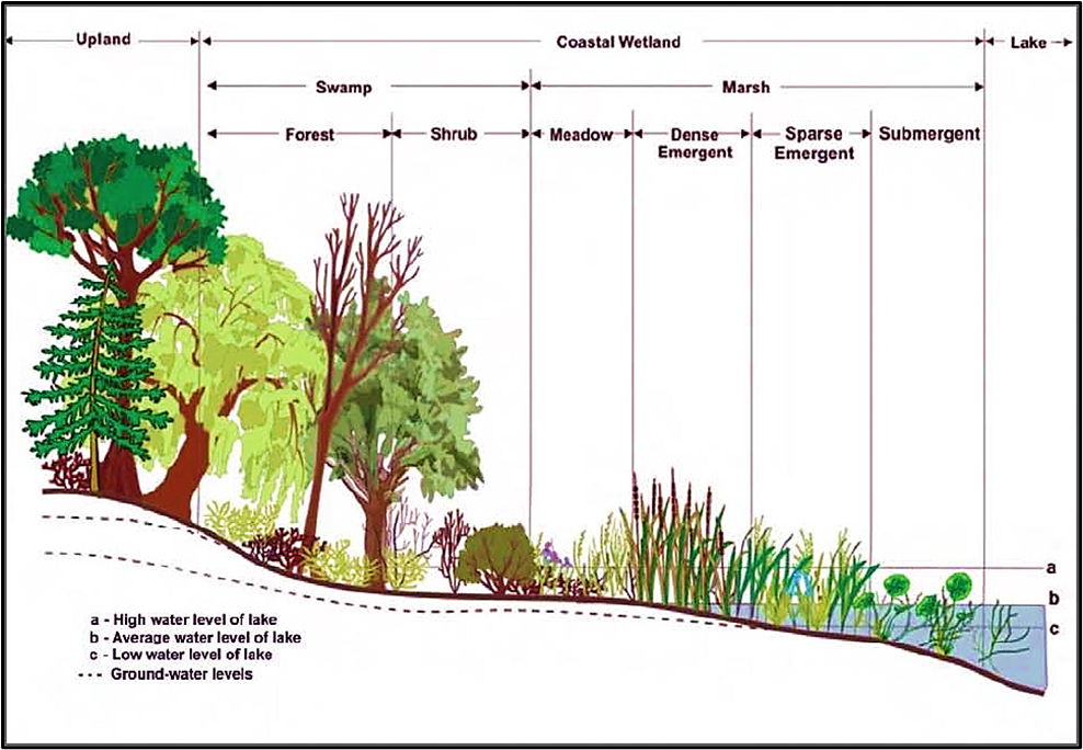
Imagine you are standing at a place where land ends and water begins. That’s where wetlands exist — the ecotone or transition zone between terrestrial (land) and aquatic (water) ecosystems.
Now, these areas have three key features:
- Hydric soils – Soils that remain waterlogged and have very little oxygen (O₂).
- Periodic flooding – Wetlands are regularly flooded by nearby water bodies like rivers or lakes.
- Hydrophytes – Plants that can survive in such waterlogged conditions, like reeds, cattails, and mangroves.
In short, wetlands act as nature’s in-between zones — not completely water, not completely land.
🌎 The Official Definition – Ramsar Convention & Indian Rules (2017)
According to the Ramsar Convention and India’s Wetlands (Conservation and Management) Rules, 2017, a wetland is:
“An area of marsh, fen, peatland, or water — natural or artificial, permanent or temporary, with water that may be still or flowing, fresh, brackish, or salty — including shallow marine areas not deeper than 6 meters at low tide.”
🔹 So, wetlands cover a wide range of ecosystems:
- Natural: Lakes, rivers, deltas, estuaries, mangroves, coral reefs.
- Human-made: Rice paddies, fish ponds, reservoirs, salt pans.
Thus, from Dal Lake to Chilika, from Sundarbans to paddy fields, all are part of the wetland family.
💧 Types of Wetlands
Let’s visualize a few examples:
- Lake littorals → Shallow margins of lakes that get alternately wet and dry.
- Floodplains → Low-lying areas beside rivers that flood during high discharge.
- Peatlands & Marshes → Waterlogged lands rich in decaying plant matter.
- Mangroves & Estuaries → Coastal wetlands with a mix of salt and fresh water.
⚖️ Wetlands vs. Lakes – The Key Differences
| Characteristic | Lakes | Wetlands (Shallow Lakes) |
|---|---|---|
| Origin | Often tectonic or geomorphic; e.g., Wular Lake | Mostly fluvial or residual; e.g., Kolleru Lake |
| Water Turnover | Permanent | Permanent or temporary |
| Water Level Changes | Small | Large |
| Thermal Stratification | Present (because they are deep) | Absent |
| Vertical Mixing | Thermally regulated | Wind regulated |
| Dominant Producers | Phytoplankton (microscopic) | Macrophytes (large aquatic plants) |
| Food Chain Type | Grazing pathway | Detritus pathway (organic decay-based) |
| Productivity | Low | High |
| Trophic Status | Often Oligotrophic (nutrient-poor, clear water) | Mostly Eutrophic (nutrient-rich, turbid water) |
| Flood Control | Negligible | Significant |
| Waste Treatment | Negligible | Significant |
🧠 In simple terms:
Lakes are deep, nutrient-poor, and clear → more like a glass of clean water.
Wetlands are shallow, nutrient-rich, and full of life → more like a thick soup of biodiversity.
🌊 Conceptual Understanding
There is no sharp line between a lake and a wetland — it’s a gradual shift.
But as a rule of thumb:
- Lakes → Usually deeper than 3 meters.
- Wetlands → Shallower, less than 3 meters, and rich in vegetation.
👉 According to the National Lake Conservation Programme (NLCP), a lake is defined as:
- Standing water body with depth ≥ 3 m,
- Water spread > 10 hectares, and
- Little or no aquatic vegetation.
So, lakes are primarily for water storage, while wetlands are for life support.
🌱 Ecological Importance of Wetlands
- Nutrient Recycling – Wetlands trap nutrients from surrounding soils and rivers.
- Habitat for Biodiversity – Birds, fishes, amphibians, and even migratory species depend on them.
- Flood Control – They act like sponges, absorbing excess rainwater.
- Water Purification – Wetlands filter sediments and pollutants naturally.
- Climate Regulation – Peatlands and mangroves store huge amounts of carbon.
Hence, they are often called “Kidneys of the Ecosystem.”
⚠️ A Note on Macrophytes
These are large aquatic plants (visible to the naked eye) such as lotus, hydrilla, and water hyacinth.
- In moderate growth, they help — controlling erosion, providing habitat, and improving water quality.
- But excessive growth (like in eutrophic conditions) leads to:
- Water quality deterioration,
- Reduced oxygen, and
- Hindrance to water use for fishing or irrigation.
Thus, wetlands need a delicate ecological balance.
🌊 Estuarine Wetland Ecosystem
Let’s begin with a simple visualization.
Imagine a river carrying fresh water, silt, and nutrients flowing toward the sea. As it reaches the coast, it doesn’t abruptly end. Instead, there’s a zone where freshwater and seawater mix — this zone is called an estuary.
Definition and Nature of Estuaries
🔹 An estuary is a partially enclosed coastal water body where a river or stream meets the sea.
🔹 The water here is brackish — neither fresh nor fully saline — with salinity ranging from 0 to 35 ppt.
🔹 It acts as a transition (ecotone) between riverine and marine ecosystems.
🧭 Examples:
- River mouths, coastal bays, tidal marshes, lagoons, and deltas (like the Ganga-Brahmaputra Delta).
At these points, the river brings fertile silt and organic matter, and the sea brings salts and minerals, creating a nutrient-rich environment.
Formation of Estuaries
Estuaries are not formed by one single cause. They can originate due to:
- Rise in sea level (submergence of coastal river valleys)
- Movement of sandbars or sediment deposition
- Glacial processes (melting or moraine damming)
- Tectonic activity (land subsidence or uplift)
They are tidally influenced systems — washed by seawater once or twice daily depending on the tidal cycle.
In narrow estuaries, strong tidal waves or tidal bores (like in the Hooghly River) can disturb the ecosystem and erode the banks.
Lagoon vs Estuary – Understanding the Difference
| Feature | Lagoon | Estuary |
|---|---|---|
| Definition | Shallow stretch of saltwater separated from the sea by a sandbank or coral reef | Partially enclosed coastal water body where a river meets the sea |
| Formation | Due to falling sea levels (coastline of emergence) | Due to rising sea levels (coastline of submergence) |
| Examples | Chilika Lake (Odisha), Kerala backwaters | Mandovi, Zuari (Goa) |
| Freshwater Source | Usually absent → higher salinity | Always present (from river) → lower salinity |
| Depth & Flow | Shallow, sluggish flow | Deeper, faster flow |
🧠 Mnemonic for UPSC:
“Lagoon lacks freshwater; Estuary embraces it.”
Ecological Importance of Estuaries
Estuaries are among the most productive ecosystems on Earth — even more than tropical rainforests or coral reefs.
Let’s understand why.
(a) Ecological Productivity
- Mixing of freshwater and seawater allows nutrients to accumulate, supporting abundant phytoplankton and marine organisms.
- Acts as an ecotone — a meeting ground of riverine and marine life.
(b) Biodiversity Refuge
- Low wave action makes estuaries calm and sheltered — ideal breeding grounds for fish, prawns, and crustaceans.
- They support mangroves, seagrass beds, and salt marshes.
(c) Mangroves as Natural Barriers
- Vast mangrove forests at estuarine edges (e.g., Sundarbans) protect coasts from cyclones and storm surges.
- They reduce wind speed and absorb wave energy.
(d) Sediment and Nutrient Dynamics
- Saline water promotes precipitation of clay and alluvium — forming deltas.
- Mangroves and roots act as natural filters, trapping silt and improving water clarity.
(e) Ecosystem Services
- Store and recycle nutrients
- Absorb pollutants and detoxify wastes
- Act as buffers between land-based catchments and the open sea
🧭 Hence, estuaries are the “lungs” of coastal ecosystems — cleansing, buffering, and nurturing marine biodiversity.
Economic Importance
It’s no surprise that 60% of the world’s population lives along estuaries and coasts.
Why? Because they offer everything humans need:
- Rich Fisheries: Natural nurseries for fish and prawns.
- Ports and Harbours: Deep, protected waters make them ideal for ports (e.g., Mormugao Port on Zuari Estuary).
- Trade & Urban Growth: Estuaries have historically been hubs of civilization (think of Kolkata on the Hooghly estuary).
- Tourism & Recreation: Backwaters, beaches, and lagoons attract tourism.
Estuarine Vegetation & Fauna
Because estuaries have fluctuating salinity, only specially adapted organisms can survive here — those capable of osmoregulation (maintaining internal salt balance).
🪴 Plant Life
- Mangroves, salt marsh grasses, seagrass beds, bulrush, and salt-tolerant trees
- Phytoplankton: Diatoms, dinoflagellates, green and blue-green algae
- Near river mouths: Dense mangrove forests
- Towards the sea: Seagrasses and algae
🐢 Animal Life
- Estuaries host sea turtles, catfish, sea lions, storks, pelicans, butterflies, and other land-water interface species.
- They provide nesting and feeding grounds for migratory birds and aquatic mammals.
Thus, estuaries are dynamic, living laboratories where every factor — river flow, tides, sediment load — keeps changing continuously.
Indian Estuarine Ecosystems
India, with its vast coastline, has:
- 14 major, 44 medium, and 162 minor rivers draining into the sea through estuaries.
- East coast estuaries – large and deltaic (e.g., Godavari, Mahanadi).
- West coast estuaries – smaller and narrow (e.g., Mandovi, Zuari, Netravati).
Many Indian ports — like Mormugao, Kochi, and Kolkata — are situated along estuaries.
Threats to Estuarine Ecosystems
Unfortunately, human interference has made these sensitive zones extremely vulnerable.
| Threat | Example/Impact |
|---|---|
| Alteration in river flow due to dams or diversions | Hooghly, Godavari, Pulicat |
| Pollution from sewage and industries | Major cities’ discharge into estuaries |
| Navigation & dredging activities | Hooghly estuary (port operations) |
| Urban and industrial expansion | Coastal reclamation, loss of mangroves |
| Intensive aquaculture (shrimp pens) | Chilika, Pulicat – blocks fish migration |
| Biodiversity loss from overfishing/prawn seed collection | Hooghly, Pulicat |
| Submergence due to sea-level rise | Coastal estuaries at risk of inundation |
🧠 UPSC insight: These same estuaries that support ports and fisheries are being degraded by the very industries and urban sprawl that depend on them — a classic case of development vs ecology conflict.
🌴 Mangrove Ecosystem
Mangroves are not ordinary trees — they are salt-tolerant (halophytes) and form one of the most unique ecosystems on Earth — an ecotone between terrestrial and marine environments.
Definition and Habitat
- Mangroves are evergreen shrubs or small trees (8–20 m tall) that grow in brackish coastal waters, estuaries, mudflats, tidal creeks, backwaters, and lagoons of tropical and subtropical regions.
- They occur below the high-water level of spring tides, meaning they are regularly inundated by seawater.
🧭 Best locations:
Where rivers bring nutrient-rich silt and deposit it in sheltered, low-lying coastal areas — ideal for mangrove growth.
Examples:
- Sundarbans Delta (Ganga–Brahmaputra–Meghna system)
- Godavari–Krishna Delta
- Bhitarkanika (Odisha)
- Gulf of Kutch (Gujarat)
Adaptive Mechanisms – The Science of Survival
Mangroves thrive where most plants would die — in salty, oxygen-poor, and constantly flooded soils.
To survive, they exhibit remarkable morphological and physiological adaptations.
⚙️ Key Adaptations:
| Adaptation | Purpose / Function |
|---|---|
| Succulent leaves | Store water and reduce evapotranspiration. |
| Sunken stomata | Prevent drying by minimizing water loss. |
| Salt-secreting glands | Expel excess salt absorbed through roots. |
| Aerial roots (pneumatophores) | Help in respiration under waterlogged, oxygen-poor conditions. |
| Prop & Stilt roots | Act as support structures against waves and tides. |
| Buttresses | Provide extra stability on soft, muddy soil. |
| Vivipary (seed germinates on tree) | Ensures seedling survival in saline, unstable mud. |
🪴 Examples:
- Rhizophora → Prop roots arching into water.
- Avicennia → Pneumatophores (vertical air roots sticking out of mud).
This makes mangroves a textbook example of ecological adaptation.
Distribution in India
Mangroves in India vary in height, structure, and diversity based on region and salinity.
(a) East Coast (Denser and More Extensive)
- Sundarbans (West Bengal) – World’s largest tidal mangrove forest; habitat of the Royal Bengal Tiger.
- Named after the Sundari tree.
- Constantly reshaped by tidal silt deposition.
- Major fauna: Tiger (EN), Saltwater Crocodile (LC), Olive Ridley Turtle (VU), River Dolphin (EN), Horseshoe Crab, etc.
- Climate threat: Even an 11-inch sea-level rise could destroy 96% of tiger habitats here (WWF study).
- Bhitarkanika (Odisha) – Second largest in India; located at Brahmani–Baitarani Delta.
- Rich in genetic diversity and typical mangrove species.
- Godavari–Krishna Delta (Andhra Pradesh) – Dense mangrove swamps on intertidal mudflats.
- Pichavaram & Vedaranyam (Tamil Nadu) – Degraded due to aquaculture ponds and salt pans.
(b) West Coast (Sparse and Scrubby)
- Found in Goa, Maharashtra, Karnataka, Kerala, and Gujarat.
- Gulf of Kutch and Kori Creek (Gujarat) – Part of the paleo Indus delta; stunted, discontinuous patches.
- Generally degraded due to limited river input and arid climate.
MISHTI Programme (2023–24)
Read Here.
Global Status of Mangroves
According to FAO Global Forest Resource Assessment, 2020:
- Found in 113 countries, covering ~14.79 million ha (≈ 1% of tropical forests).
- Largest mangrove regions:
- Southeast Asia → 5.55 million ha
- Africa, Americas, and Oceania follow.
- Top 4 countries (40% of total cover):
- Indonesia (19%), Brazil (9%), Nigeria (7%), Mexico (6%).
- India: 4,992 sq km (ISFR 2021) — 0.15% of total geographical area.
Why Mangroves Don’t Grow Beyond Subtropics
- They require high solar radiation because their salt filtration mechanisms and water regulation are energy-intensive.
- Thus, they are confined between 24°N and 38°S latitudes, mainly in tropical and subtropical intertidal zones.
Ecological and Economic Importance
| Function | Explanation |
|---|---|
| 🌊 Coastal Protection | Dense root systems dissipate wave energy, protect against tsunamis and storm surges. |
| 🧱 Erosion Control | Roots trap sediments, promote land accretion, and stabilize shorelines. |
| ☔ Flood Moderation | Slow down tidal floods, protect coastal lowlands. |
| 🧪 Pollution Control | Act as natural filters, trapping heavy metals and nutrients. |
| 🌍 Carbon Sink | Efficiently absorb and store CO₂ — vital for climate regulation. |
| 🐠 Biodiversity Nursery | Provide breeding, spawning, and nursery grounds for fish and crustaceans. |
| 👨👩👧👦 Livelihood Support | Honey, tannins, wax, firewood, medicinal plants, edible plants, fishing — all sustain local communities. |
🧭 Hence: Mangroves are “the biological shields of coastal ecosystems.”
Threats to Mangroves
(a) Aquaculture, Agriculture, and Salt Ponds
- Thousands of hectares cleared for shrimp farming, mariculture, and crop cultivation.
- Consequences:
- Chemical feed leads to pollution and eutrophication.
- Oxygen levels fall → destruction of nearby marine life.
(b) Coastal Development & Lumbering
- Reclamation for hotels, ports, desalination plants, and infrastructure.
- Mangrove wood used for charcoal, fencing, and construction.
📉 Result:
- Habitat loss → altered hydrology and salinity.
- Biodiversity loss → decline in fish species and genetic diversity.
- Increased flood and climate vulnerability.
Case Study: Mumbai’s Coastal Road Project
A classic example of development vs environment conflict.
| Aspect | Details |
|---|---|
| Project Length | 29.2 km |
| Land Reclaimed | 90 hectares (prone to tidal flooding) |
| Mangroves Affected | 1,000 trees cut |
| Cost | ₹11,300 crore |
| Impact | Increased flooding, tidal erosion, beach loss, destruction of natural drainage, loss of fishery grounds. |
🧭 Issue: Compensatory plantation (3x area) cannot replace original ecological services — new mangroves take years to mature and may not grow in the same tidal setting.
Climate Change Impacts
- Sea-level rise threatens low-lying mangroves (e.g., Sundarbans).
- Clearing mangroves releases stored carbon → worsens global warming.
- Some species may not adapt to increased salinity or prolonged inundation.
Limitations of Replantation
- Mangroves have low species diversity compared to tropical forests.
- Replanting often uses monoculture (single species) instead of diverse native species.
- Hence, reforestation cannot fully restore the lost ecological complexity.
🔹Importance of Wetlands
Wetlands are among the most productive ecosystems on Earth, comparable to rainforests and coral reefs. They sustain human life, biodiversity, and climate stability.
🌱 Key Ecosystem Services
| Function | Explanation |
|---|---|
| 💧 Freshwater Supply | Act as natural reservoirs that recharge groundwater. |
| 🍚 Food & Raw Material Source | Provide fish, rice, reeds, timber, honey, and building materials. |
| 🐦 Biodiversity Habitat | Home to aquatic flora, fauna, and migratory birds. |
| 🧳 Tourism Resource | Support sustainable tourism and eco-tourism. |
| ⚗️ Water Purification | Filter sediments, heavy metals, and pollutants. |
| 🔄 Nutrient Recycling | Convert organic matter into nutrients for plant growth. |
| 🌧️ Flood Mitigation | Absorb floodwater and release it slowly, reducing runoff. |
| 🪨 Shoreline Protection | Act as a riparian buffer against erosion and pollutants. |
| 🌾 Genetic Reservoir | Preserve genetic diversity, especially for crops like rice. |
| 🌍 Carbon Sink | Absorb CO₂, thus mitigating climate change. |
🧠 In essence: Wetlands are life-support systems for humans and nature alike — regulating water, supporting biodiversity, and storing carbon.
⚠️ Reasons for the Depletion of Wetlands
Despite their importance, wetlands are rapidly disappearing due to reckless human activities.
🚨 Major Causes:
- Pollution Overload:
Industrial effluents, sewage, and farm runoff exceed the wetland’s natural recycling capacity. - Encroachment & Land Conversion:
Wetlands are drained for agriculture, urban expansion, or illegal construction. - Habitat Destruction & Deforestation:
Alters the ecological balance and impacts native species. - Overfishing & Aquaculture:
Shrimp farming and fish pens degrade soil and water quality. - Overgrazing:
Trampling in marshy areas destroys vegetation cover. - Sand Removal & Quarrying:
Weakens the bed, exposing wetlands to tidal bores and wave erosion.
🔧 Mitigation of Wetland Destruction
To save wetlands, the focus must shift from exploitation to wise use and community participation.
✅ Key Conservation Measures
| Approach | Strategy |
|---|---|
| 🛰️ Mapping & Demarcation | Use remote sensing and GIS to define wetland boundaries clearly. |
| ⚖️ Strict Enforcement | Impose penalties for encroachment and pollution. |
| 🧫 Effluent Treatment | Treat industrial and agricultural discharges before release. |
| 🌱 Sustainable Use | Allow time for natural regeneration; avoid overharvesting. |
| 🌳 Afforestation & Soil Conservation | Prevent siltation and erosion. |
| 🚫 Control of Invasive Species | Stop the spread of water hyacinth and other exotics. |
| 🐃 Regulate Grazing & Aquaculture | Restrict intensive shrimp or fish farming. |
| 🐦 Wildlife Protection & Ecotourism | Encourage sustainable livelihoods and awareness. |
| 🧍♂️ Community Involvement | Engage local communities in wetland protection. |
🇮🇳 Wetlands of India – Extent and Types
According to the National Wetlands Atlas (ISRO, 2011):
- India has 15.26 million ha under wetlands (≈4.6% of total land area).
- 70% of these are human-made (mainly paddy fields).
- Inland wetlands: 69.2% (10.56 million ha); rest are coastal.
🌊 Major Wetland Types:
| Region | Examples |
|---|---|
| Himalayas | Glacial lakes, high-altitude marshes |
| Gangetic–Brahmaputra Plains | Floodplains, mauns, beels, chaurs, jheels |
| Arid & Semi-arid (Rajasthan–Gujarat) | Salt lakes like Sambhar, Pachpadra, Didwana |
| Deccan Peninsula | Man-made lakes like Varthur, Amruthalli (Bengaluru) |
| Coastal Zone | Lagoons, estuaries, mangroves, coral reefs, backwaters |
🧠 UPSC Note:
Wetlands can be natural (lakes, deltas, estuaries) or artificial (paddy fields, reservoirs).
🧩 National Plan for Conservation of Aquatic Ecosystems (NPCA)
Read here.
⚖️ Legal Framework: Wetlands (Conservation and Management) Rules
(a) 2010 Rules
- Notified under the Environment (Protection) Act, 1986.
- Established the Central Wetlands Regulatory Authority (CWRA) under the MoEF Secretary.
- Classified wetlands and regulated their drainage areas.
🚫 Prohibited Activities
- Industrialisation and permanent construction
- Solid waste dumping
- Untreated waste discharge
- Land reclamation
⚠️ Controlled Activities (With Permission)
- Aquaculture
- Agriculture
- Dredging (for silt removal)
✅ Appeals against CWRA decisions were allowed before the National Green Tribunal (NGT).
(b) 2017 Rules – Key Changes
The Wetlands (Conservation and Management) Rules, 2017 replaced the 2010 Rules.
🔄 Major Shifts
- Decentralisation:
Powers delegated to State/UT Wetland Authorities (SWAs) for identification, notification, and management. - National Wetlands Committee (NWC):
- Advisory body under MoEF.
- Guides States on wise-use principles and reviews Ramsar Site management.
- Nodal authority for NPCA.
- State Wetland Authorities (SWAs):
- Headed by the State Environment Minister.
- Include experts from ecology, hydrology, fisheries, and socio-economics.
- Must prepare:
- List of all wetlands (within 3 months)
- Notify priority wetlands (within 6 months)
- Create a digital inventory (within 1 year, updated every 10 years).
🚫 What Cannot Be Notified as Wetlands
- River channels, paddy fields, man-made water bodies, aquaculture ponds, salt pans, irrigation tanks, recreation areas.
- Areas already protected under:
- Indian Forest Act (1927)
- Forest Conservation Act (1980)
- Wildlife Protection Act (1972)
- Coastal Regulation Zone (2019)
❌ Prohibited Activities (Under 2017 Rules)
- Conversion for non-wetland use
- Setting up industries or expansion
- Handling or dumping hazardous substances
- Discharge of untreated waste
- Encroachment or permanent structures (except small boat jetties)
⚠️ Concerns and Loopholes in 2017 Rules
| Issue | Concern |
|---|---|
| 🏛️ Central Government Discretion | The Centre can allow even prohibited activities on State request — risk of misuse. |
| 🚫 No Appeal Mechanism | Unlike 2010 Rules, there’s no appeal provision to NGT. |
| ⚖️ Subjective Definition of “Wise Use” | Left to interpretation by States, allowing political or commercial manipulation. |
🧠 UPSC Insight:
The “wise-use principle” originates from the Ramsar Convention, meaning use of wetlands without compromising their ecological character — but its vagueness in Indian law leaves room for misinterpretation.
🌿 Core Takeaway
Wetlands are not wastelands — they are living systems that sustain water, wildlife, and weather.
Conservation must combine science, law, and people — otherwise, India’s 15 million hectares of wetlands will silently vanish under the weight of “development.”
This topic is part of the complete Environment Notes for UPSC. Explore the full subject coverage here.