
Concentric Zone Theory – E.W. Burgess (1923)
“A city is not built randomly. It grows systematically — layer by layer.”
This was the foundational idea behind E.W. Burgess’ Concentric Zone Model, also known as the Ring Theory. Burgess, a sociologist, studied the structure of American cities, especially Chicago, and presented a scientific urban model in 1923.
📌 Core Idea:
Urban growth happens outward from the center, forming concentric rings, where each ring represents a specific land use or social group.
💡 Just like when you drop a stone in a pond and waves ripple outward, cities too expand in rings from the center.
🏙️ The Five Zones in the Concentric Zone Model
Let’s explore each zone, one by one, moving outward from the city center.
Zone I – Central Business District (CBD): The Urban Core
- This is the heart of the city — economically, socially, and culturally.
- Also called Downtown.
🔍 Features:
- Skyscrapers, commercial offices, retail shops.
- High land value, dense traffic, vertical growth.
- Divided into:
- (i) Retail core (shopping, business)
- (ii) Wholesale district (warehouses, logistics)
📌 CBD is the transport hub and the most accessible area of the city.
Zone II – Zone in Transition: The Decaying Ring
- Lies just outside the CBD and often overlaps with it.
🔍 Features:
- Residential buildings slowly being taken over by light industry and small businesses.
- Slums, immigrant housing, poverty, and crime.
- This zone is marked by urban decay and instability.
📌 This is the most dynamic and unstable zone, showing early signs of urban renewal or gentrification in modern times.
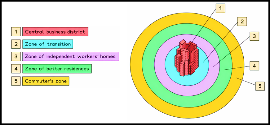
Zone III – Working-Class Residential Zone
- Also known as the “Working Men’s Homes”.
🔍 Features:
- Old but stable residential areas.
- Occupied by blue-collar workers who commute to factories nearby.
- These are often second-generation immigrants who have improved slightly from Zone II.
📌 This zone shows moderate stability, reflecting aspirations of the working class.
Zone IV – Middle-Class Residential Zone
- This ring is more spacious and organized.
🔍 Features:
- Middle-income families: small business owners, clerks, teachers.
- Planned layouts, parks, schools, basic amenities.
- More socially homogeneous.
📌 This is a zone of urban comfort, away from chaos, but still close enough to CBD for work.
Zone V – Commuter Zone (Suburbs and Hinterlands)
- The outermost ring, often beyond city limits.
🔍 Features:
- People live here but work in the city — they commute daily.
- Includes dormitory towns, satellite cities, and even rural areas.
- Travel time to CBD: ~1 hour.
📌 Represents urban sprawl, and the connection between urban core and rural periphery.
❗ Criticisms of the Concentric Zone Theory
Though widely influential, the model has been heavily criticized, especially when applied beyond American cities.
🔹 Major Criticisms:
- Geographical Determinism Ignored:
- It overlooks topography like rivers, hills, and natural barriers that distort urban layout.
- However, Burgess himself acknowledged such zonal distortions.
- Ideal Shape Problem:
- The model assumes a circular shape, but real-world cities often grow in irregular, linear, or star-like patterns.
- Transportation Bias:
- In reality, business and industry grow along transport corridors like highways and railways — not in perfect circles.
- Mixed-Use Reality:
- In modern cities, commercial, residential, and industrial zones overlap in every area.
- Lack of Universal Application:
- Works well for early 20th-century American cities, especially Chicago, but not suitable globally — especially in developing countries, or cities with colonial legacies.
🧠 Final Reflection – Understanding the Model’s Legacy
“Every theory is a lens, not a blueprint.”
Burgess’ model was revolutionary for its time, offering one of the first scientific models of urban growth. Even though it has limitations, it laid the foundation for later models like:
- Hoyt’s Sector Model
- Multiple Nuclei Model
And even today, in urban planning and UPSC answer writing, this theory is valuable for:
✅ Explaining urban structure,
✅ Understanding spatial inequality,
✅ Comparing with Indian urban realities.