
Methods of Delineation of Regions
“Regionalisation tells us how to divide the space; delineation tells us where to draw the lines.“
Once a formal or functional region is conceptualized, geographers need specific methods to delineate (mark out) the boundaries of these regions on the map. These methods vary depending on the type of region — formal or functional.
🔷 Delineation of Formal Regions: Qualitative Methods
Formal regions are identified based on uniformity or similarity in one or more selected features (e.g., soil, language, income, rainfall).
The aim is to group spatial units that are similar within and distinct from outside.
✨ Key Characteristics:
- Based on homogeneity in chosen variables.
- Boundaries are not always sharp, but drawn where similarity ends.
- It uses qualitative assessment, though sometimes aided by data.
📌 Boundary Girdle Method (Map Superimposition Method)
🗺️ A visual-cartographic approach.
- Prepare multiple thematic maps (e.g., rainfall, soil, vegetation, language).
- Superimpose one map over another.
- Observe where overlapping similarities occur.
- The common area where most characteristics match becomes a region.
🧠 Analogy:
Like tracing transparency sheets of different organs of the body to identify the region of disease — geographers trace different maps to find the core of uniformity.
📌 Weighted Group Index Number Method (By Boudeville)
A more statistical method for identifying problem regions (especially economic).
- Divide area into local units.
- Assign weights to each indicator (e.g., unemployment = 60%, per capita income = 40%).
- Compute weighted indices for each unit.
- Units with extreme values (e.g., low income, high unemployment) are grouped to form a problem region.
🧠 Example:
- Planning backward regions for special economic schemes like Aspirational Districts in India.
📌 Factor Analysis Method
Based on multivariate statistics — identifying underlying (latent) variables causing multiple problems.
- Many symptoms (illiteracy, pollution, health issues) may originate from a single root cause — say, poverty.
- Through factor analysis, geographers isolate such core issues and delineate regions based on it.
✅ Benefit:
- Plans based on root causes are more effective and resource-efficient.
🧠 Analogy:
Instead of treating fever, cough, weakness separately, doctor finds viral infection as the source.
Geographer does the same through factor analysis.
🔶 Delineation of Functional Regions: Quantitative Methods
Functional regions are interaction-based. They form around a central node (like a city) and its surrounding area based on flows (people, goods, information).
These methods are more quantitative and depend on measurable connectivity.
📌 Flow Analysis Method
Defines region by mapping actual flows from center to periphery.
- Flows may be commuting, trade, communication, etc.
- Flow intensity decreases with distance from the center.
- The region’s boundary is drawn where flow intensity drops significantly or overlaps with another center’s sphere.
🧠 Example:
- A city like Delhi has functional region defined by:
- Daily commuting of workers
- Goods supply to nearby markets
- Administrative influence
📌 Gravitational Analysis Method
Based on Newton’s Law of Gravity applied to human geography.
- Interaction between places is:
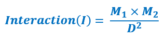
Where:
- M1, M2 = Mass of centers (e.g., population, income, economic size)
- D = Distance between them
- Larger centers pull more, but distance weakens the pull.
🧠 Application:
- Helps predict:
- Trade routes
- Urban hinterlands
- Service zones (e.g., hospitals, banks)
🧠 Summary Table: Methods of Delineation
| Region Type | Method | Approach | Key Focus |
| Formal | Boundary Girdle Method | Qualitative, Cartographic | Overlapping features |
| Weighted Index Method | Semi-quantitative | Problem region identification | |
| Factor Analysis | Statistical | Root cause identification | |
| Functional | Flow Analysis | Quantitative | Direction + intensity of flow |
| Gravitational Method | Quantitative (Model-based) | Mass-distance interaction |
✅ Final Reflection:
“A region is not just a patch of land—it is a conceptual construct, whose boundaries depend on what we measure, how we perceive, and why we study.”
The delineation methods, therefore, reflect:
- The purpose of regionalisation,
- The type of region (formal or functional),
- And the tools — cartographic or statistical — that geographers use.