
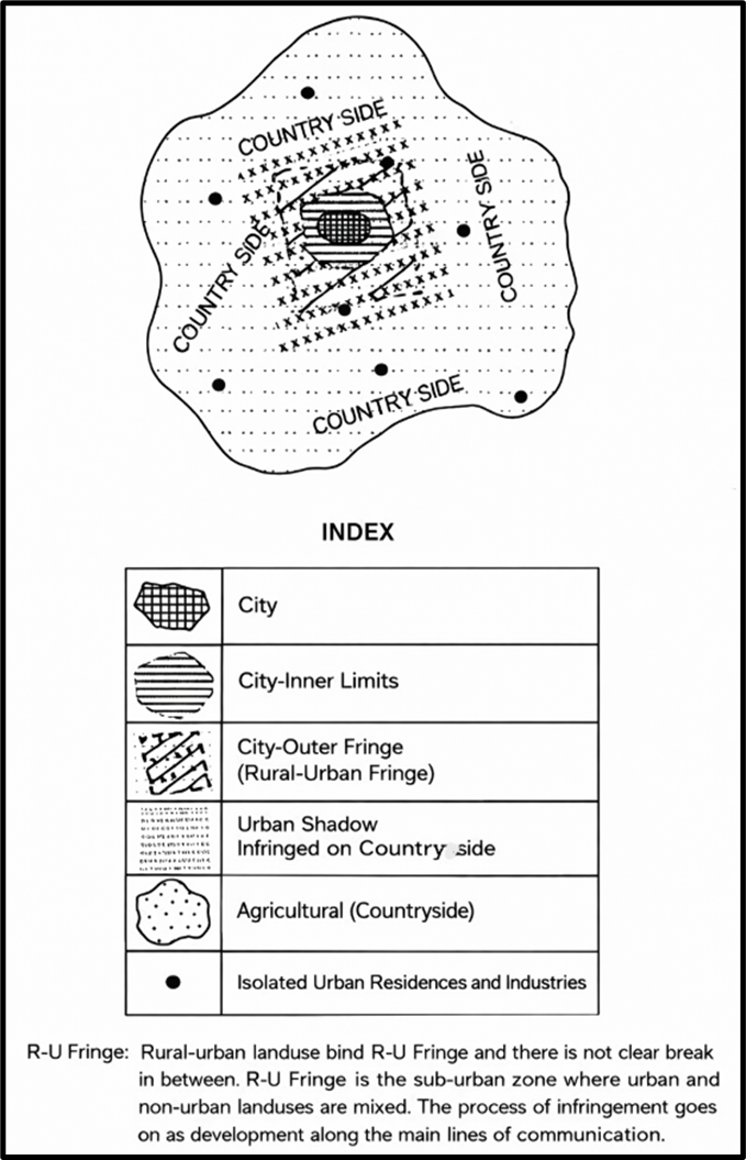
Rural-Urban Fringe
Let’s begin with a very basic but profound question:
Is there a strict boundary where a city ends and a village begins?
The answer is no, and this ‘in-between’ zone—where the characteristics of both city and village are found—is called the Rural-Urban Fringe, often abbreviated as R-U Fringe.
What Is the Urban Fringe?
- When we look at a modern city, especially one that is expanding, we find that its edge does not end abruptly.
- Instead, it gradually blends into the rural areas. This blending creates a zone that shows both urban and rural features.
👉 So, don’t think of it as a city ending and village beginning. Instead, imagine it like a color gradient—not a sharp line, but a smooth transition.
Mixed Land Use: The Key Indicator
- The most important feature here is “mixed land use”.
- You’ll find urban-type buildings like factories and apartments, and also rural features like fields, wells, or cattle sheds—side by side.
- This mix is not random, but a reflection of the changing character of the land.
This is why, to identify the rural-urban fringe, we don’t look at administrative boundaries—but at how the land is being used or modified.
Continuity of Movement: Western Cities
- In Western cities, especially in North America and Europe, there is no visible break between urban and rural areas.
- Why? Because of the “journey to work” phenomenon.
- People live in suburbs or on the city’s outskirts and commute daily to the city center using cars.
- This daily flow physically and functionally connects the fringe with the city.
Indian Context: The Village Commute
- In India, this same function is performed by village residents.
- People living in villages near cities travel to the city every day for work—whether as laborers, vendors, or in services.
👉 This creates a functional linkage—where the village provides labor, and the city provides employment.
The Role of Land Use
- Across the world, whether in India or the West, land use is what binds the village and town together.
- There is no clear-cut division, but rather a continuum.
📌 So, instead of asking “Where does the city end?”, we should ask “What is happening on the land here?”
The Social Transition Zone
- Now comes an interesting angle: the social aspect.
- The Rural-Urban Fringe is also called a “transitional zone” in social terms.
- This is because both rural and urban people live here, often side by side.
But modern developments—like better roads, mobile connectivity, and frequent movement of people and goods—have blurred this rural-urban social divide.
Western Perspective: Fading Fringe
- In Western Europe and North America, the influence of the city is so widespread that urban lifestyles are found far from the city’s edge.
- Because of this diffused urban impact, it is often argued that the rural-urban fringe has become irrelevant or hard to define.
Final Understanding: The Fringe as a Suburban Zone
- To sum it all up:
- The Rural-Urban Fringe lies just outside the official city limits.
- It’s a rural area experiencing urbanisation.
- Residential colonies, industrial areas, and urban services like schools, hospitals, and malls are gradually emerging here.
- All this happens especially along major roads, and often around existing villages or small towns.
In essence, this zone is a dynamic laboratory—where rural and urban features constantly interact, clash, and sometimes merge.
Conclusion
The Rural-Urban Fringe is not just a geographical space—it is a process of transformation. Understanding it is essential for:
- Urban planning,
- Resource management,
- And solving urban-rural conflicts.
So next time you cross a village just outside a growing city and see a mall beside a paddy field, remember—you’re in the Rural-Urban Fringe, where the city meets the village.
Understanding the Complex Pattern of Transition in the R-U Fringe
Now that we understand what the Rural-Urban Fringe is—let’s go deeper.
Let me begin with a relatable analogy:
Think of the R-U Fringe like a boundary between two cultures—city and village. Now imagine this boundary is not a line on a map but a zone where things are constantly changing, shifting, and blending. That’s why we say: this zone is in transition.
But this transition is not random. It follows a pattern, and this pattern has three key aspects:
📌 The Three Aspects of Transition in R-U Fringe
The Rural-Urban Fringe exhibits three distinct but interrelated transitions:
- Physical Transition
- Social Transition
- Economic Transition
1. Physical Aspect: The Inner Zone of Urban Invasion
- This is the most visible layer of change.
- Here, you find an “inner fringe”, which is closest to the city.
- This zone is already in an advanced stage of transformation—rural landscapes are visibly changing into urban land uses.
👉 Imagine rural fields turning into:
- Housing colonies
- Shopping complexes
- Warehouses or workshops
This physical shift marks the first and most tangible change in the R-U Fringe.
2. Social Aspect: Changing Attitudes in the Outer Fringe
Now we move a bit outward—toward the outer fringe.
- Here, land may still look rural.
- People may still wear traditional clothes or follow rural customs.
- But their thinking has started to change.
This is the “social transition”—where urban ideas and lifestyles begin to infiltrate rural communities.
Examples:
- Youth in villages start preferring city jobs over farming.
- Families begin valuing education, modern healthcare, and nuclear family structures.
- There’s an increase in aspirational consumption—buying bikes, smartphones, etc.
👉 It’s a silent revolution. The attitudes, values, and goals of people begin to shift—from agrarian to urban-industrial orientations.
3. Economic Aspect: The Urban Shadow Over Agriculture
Lastly, we come to the economic transformation—the third and perhaps most strategic layer of the R-U Fringe.
- This is where agricultural land begins to lose its original economic identity.
- With the expansion of the city, farming becomes less profitable or even unsustainable.
- Land prices skyrocket, and slowly, farmers start selling off their land.
What replaces agriculture?
- Farmhouses built by city elites.
- Non-farm residences of retired people or city dwellers seeking peace.
- Commercial plots waiting for real estate development.
👉 This creates what geographers call the “Urban Shadow”—a zone where city influences darken or overshadow traditional rural economy, even if no high-rise buildings have come up yet.
🧠 Now, let’s Sum It Up:
| Aspect | Zone | Nature of Transition |
|---|---|---|
| Physical | Inner Fringe | Land use changes → Rural → Urban (visible transformation) |
| Social | Outer Fringe | Attitudes change → Rural mindset → Urban values |
| Economic | Wider Fringe/Urban Shadow | Agriculture declines → Urban economy intrudes (non-farm uses) |
🌱 Final Thought
“Rural-Urban Fringe is not just a place—it is a process in action.”
Cities do not simply expand outward—they transform everything in their path → Land, Lifestyle, Livelihood
So when you next see a village where farmland is shrinking, where boys carry laptops and uncles drive SUVs, you’re not just seeing a cultural shift—you are witnessing geography in action, at the rural-urban frontier 😊
Understanding the Characteristics of R-U Fringe
So, once a city starts expanding, it doesn’t just grow geographically—it begins to change the very nature of the surrounding rural areas. Different geographers and researchers have studied this zone and noted key features that help us understand its complex character.
Walter Firey’s Observations – Flint City, Michigan, USA
Let’s begin with the American experience, as noted by Walter Firey while studying Flint City (Michigan).
He identified five key characteristics of the R-U Fringe. Think of these as “5 stress points” experienced in the transition zone:
(i) Land Usurpation
- Large tracts of agricultural land are taken over for:
- Residential colonies (suburbs)
- Commercial establishments
- Educational institutions
- 👉 This reflects a shift from primary to tertiary/quaternary uses.
(ii) Sporadic Industrial Growth
- Industries are not planned in a systematic way.
- They “crop up” sporadically—meaning randomly and unevenly.
- This causes fragmentation of land and poor infrastructure.
(iii) Tax Burden
- Residents of the fringe often pay high taxes to maintain urban amenities (like garbage collection, roads, water supply).
- But these areas are not fully urban, so they don’t always get proper services in return.
(iv) Soaring Land Values
- Due to urban expansion, land prices shoot up.
- But the people living there—often middle class—struggle to afford the cost of building or buying houses.
(v) Social Shift
- Attitudes of people begin to change—moving from rural conservatism to urban aspirations.
- This is the “psychological transition”—people start living like urban citizens even if the infrastructure is still rural.
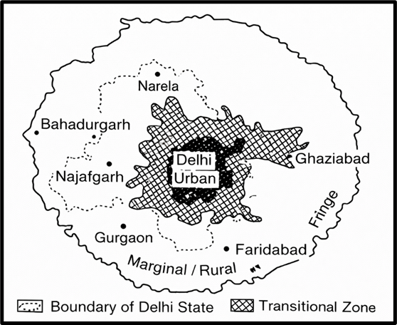
Sudesh Nangia’s Study – Delhi Metropolitan Region (1976)
Moving from the U.S. to India—Sudesh Nangia studied the R-U fringe of Delhi, and her findings are highly relevant for Indian urban geography.
Here are her key observations:
(i) Size & Shape
- The R-U fringe in Delhi covered 212 sq km, including 177 villages.
- Unlike a simple circular ring, it was polygonal in shape—due to uneven city growth and natural barriers.
(ii) Structural Features (use the mnemonic S.I.M.P.L.E.):
| Letter | Feature |
|---|---|
| S | Slums and squatter settlements with unplanned growth |
| I | Industrial units replacing agricultural land |
| M | Mixed land use (residential + commercial + industrial) |
| P | Poor urban amenities in many dispersed settlements |
| L | Lack of infrastructure, like roads, water, waste disposal |
| E | Presence of essential facilities like sewage plants and recreation centres |
This shows the R-U fringe is neither fully urban nor fully rural—it’s a chaotic but functioning hybrid.
R.L. Singh – R-U Fringe of Varanasi
R.L. Singh provides an insightful definition:
“The R-U fringe is an area where most of the rural land is forced into urban uses prematurely.”
What does this mean?
- Land gets converted before there is proper urban planning.
- Example: Farmland becomes a housing colony, but there’s no drainage, no road, no transport connectivity.
- This causes urban dysfunction.
👉 It’s like a half-baked urbanization—the form is urban, but the function is still rural.
U. Singh – KAVAL Towns
He studied the fringe areas of KAVAL towns (Kanpur, Agra, Varanasi, Allahabad, and Lucknow).
⚠️ Key Observation:
- The fringes of these towns have merged together, creating a continuous urban sprawl.
- This results in:
- Slums
- House and traffic congestion
- Long daily commuting distances
He essentially warns us: “These fringe zones are inheriting all the problems of big cities, but without their planning or facilities.”
🧠 Summary Table – Characteristics by Scholars
| Scholar | City/Region | Key Features |
|---|---|---|
| Walter Firey | Flint City, USA | Land usurpation, sporadic industries, tax burden, high land values, social shift |
| Sudesh Nangia | Delhi Metropolitan Region | Large polygonal fringe, slums, squatter settlements, mixed land use |
| R.L. Singh | Varanasi | Premature urban land use without proper urban infrastructure |
| U. Singh | KAVAL towns | Coalesced urban fringes, slums, congestion, long commutes |
✍️ Conclusion
The Rural-Urban Fringe is like a battleground—where the village is trying to survive and the city is trying to expand.
Each scholar has shown us how:
- Land gets transformed
- People’s lives get disrupted
- Urbanization without planning leads to new challenges
So, if you’re writing a UPSC answer or an essay, remember:
The R-U fringe is not just a place, it is a reflection of how urban growth can create opportunity—but also chaos—if left unmanaged.
Delimitation of the R-U Fringe
Delimitation simply means: Where does the city end and the rural begin? Or vice versa?
But the challenge is: this boundary is not clear—it is blurred, gradual, and dynamic.
📍 Ideal Method:
- Ideally, delimitation requires intensive fieldwork, going village-to-village, typically within a 10–15 km radius of the city.
- This method should identify how land use, occupation, social attitudes, and infrastructure transition from rural to urban.
Think of this like “diagnosing the patient by visiting every organ, not just reading lab reports.”
⚠️ Reality in India: Limited Ground Research
- In India, most delimitation efforts do not use actual field surveys.
- They rely on:
- Sample surveys
- Secondary data from Census of India
❗The problem: census data offers quantitative trends, but not the qualitative transition that’s vital to understanding R-U fringe.
🏙️ Cities Studied (but inadequately):
- Delhi, Bangalore, Varanasi, Hyderabad, Kolkata – all have been studied.
- However, these suffer from:
- Ambiguous definitions
- Inadequate conceptual clarity
- Over-reliance on outdated or aggregated census data
🧩 Structural Components to Consider in Delimitation:
For proper delimitation, we must understand its structural composition, which includes:
| Component | Description |
|---|---|
| Municipal limits | The formal boundary of the city |
| Contiguous urbanized towns | Nearby small towns merging into the city |
| Urbanized villages | Villages that have adopted urban features |
| Functionally associated villages | Villages that are economically and socially tied to the city |
It’s a multilayered zone—so delimitation should be based not on political boundaries, but on functional and spatial realities.
Conclusion: Structure and Challenges of R-U Fringe
After understanding its characteristics and delimitation, let’s summarise what the R-U fringe actually looks like.
🧱 Three Zones of Transition:
| Zone | Nature of Transition |
|---|---|
| Inner Zone | Advanced transition from rural to urban land use. Often fully urban in function, but not always in planning. |
| Outer Zone | Ongoing change – urban influences are visible, but rural character still lingers. |
| Diffused Periphery | Scattered urban traits – non-farm residences, some city functions, but rural land use dominates. |
It’s like water gradually mixing into milk—no sharp boundary, but a gradient of transformation.
🏭 Land Use Patterns at the Fringes:
Especially in Western cities, the fringe includes:
- Commercial complexes
- Wholesale markets
- Industries (often noxious and polluting)
- Oil storage, sewage plants, cemeteries
- Out-of-town shopping centres
These developments often create ‘unpleasant environments’ at the city’s edge.
🇮🇳 In the Indian Context: Urban Chaos at the Fringes
- The Indian R-U fringe is often unplanned and chaotic.
- Settlements merge haphazardly.
- Common features:
- Jhuggi-jhonparis (informal slums)
- Drainageless, unpaved lanes
- Heavy traffic congestion
- Lack of basic amenities
- The original agricultural land (like baris and orchards) is lost to unplanned urban growth.
It’s urban in name but rural in pain.

🚨 Final Insight: Biggest Challenge to Urban Planning
“**R-U fringe areas in India present the greatest challenge to the urban planner.””
Why?
- Because they sit outside formal governance zones, yet face the pressures of urban growth.
- There’s no clear authority, no holistic vision, and no infrastructural integration.
- Planning them requires interdisciplinary coordination, data-driven delimitation, and community engagement.
📌 Summary Points for Answer Writing:
- R-U fringe is a dynamic, transitional zone—not rural, not fully urban.
- Delimitation is ideal through intensive fieldwork, but India relies heavily on secondary data.
- Studies in Indian cities suffer from conceptual ambiguity.
- Structural composition includes municipal limits, urban villages, peripheral towns, and functional linkages.
- The fringe shows a three-tiered transition—inner (advanced), outer (ongoing), and diffused (scattered).
- Western fringes face environmental degradation; Indian fringes face unplanned, jumbled urbanization.
- Urban fringe = crucial zone for intervention in urban policy and planning.