
Sector Model of Urban Land Use – Homer Hoyt (1939)
“Urban growth does not always spread like ripples in water — sometimes it shoots out like the rays of the sun.”
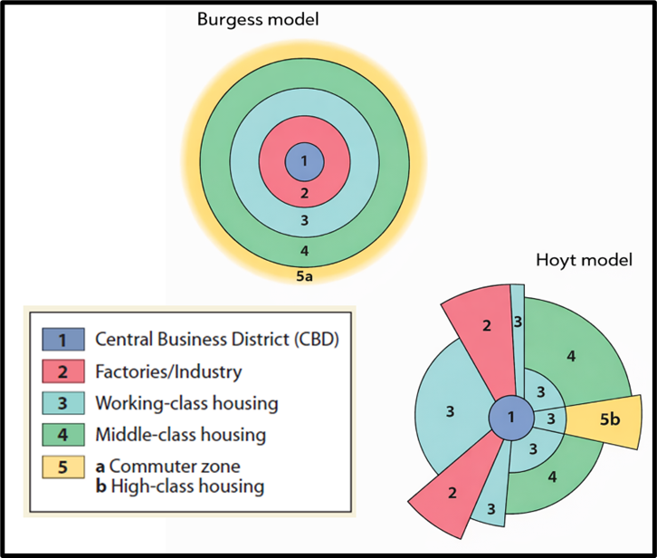
This is the core of Hoyt’s Sector Theory, developed in 1939 as an improvement over the Concentric Zone Model by E.W. Burgess.
🔁 Background: Why a New Model?
- Burgess’ Concentric Ring Model (1920s) worked well for horse-cart and pedestrian-based cities.
- But by 1930s:
- Automobiles became common.
- Transport routes like roads and railways altered city accessibility.
- Hence, cities no longer expanded evenly in circles, but along major routes.
🔍 Main Idea of Hoyt’s Sector Theory
“Urban land use is influenced not just by distance, but also by direction.”
🚧 City grows in sectors or wedges, not circles.
- Land uses like residential, commercial, or industrial spread outward along transport corridors.
- Each sector is a wedge, radiating from the city center.
- Different land uses develop in specific directions based on accessibility, environment, and rent-paying capacity.
🧩 Key Features of the Sector Model
1️⃣ City Structure
- At the center: CBD (Central Business District)
- From here, sectors of land use radiate outward like slices of a pie.
2️⃣ High-Income Housing Sector
- Tends to develop in a specific direction (e.g., along a scenic road, parkland, or waterfront).
- Once established, it pulls the entire city’s growth in that direction.
- Old houses left behind become middle-income or lower-quality over time.
3️⃣ Low-Income Areas
- Develop in opposite sectors — often along polluted, industrial zones or transport corridors (rail lines, factories).
🧠 Key Principles Underlying Hoyt’s Model
| Feature | Description |
|---|---|
| Transport-driven Growth | Urban expansion follows major routes. |
| Directional Expansion | Land use is sectoral, not circular. |
| Dynamic Nature | High-rent areas move outward, changing spatial patterns. |
| Urban Pull Effect | High-income sectors often shape city growth direction. |
🧱 Hoyt vs Burgess: Comparison Table
| Feature | Burgess (Concentric) | Hoyt (Sector) |
| Pattern | Circular rings | Radial wedges (sectors) |
| Driving Force | Distance from CBD | Transport routes & direction |
| Land Use Allocation | Based on concentric zones | Based on accessibility sector |
| Rich vs Poor Areas | Evenly spread in rings | Clustered in specific sectors |
📉 Criticism of Hoyt’s Model
| Critique | Explanation |
|---|---|
| Still monocentric | Assumes single CBD. Doesn’t account for multiple nuclei in modern cities. |
| Limited to residential use | Focuses more on housing patterns than commercial or industrial areas. |
| Ignores topography | Real city growth is constrained by physical and legal factors. |
| Based on American cities | May not be fully applicable to Indian or Asian urban forms. |
🧩 Conclusion
“Urban space is not just about where, but also about which direction.”
The Sector Theory shifted the understanding of urban growth from uniform expansion to directional specialization — making it a major conceptual advance in urban geography.