
Ganga River System
Assume India as a living body. The Ganga River System is like its central nervous system, carrying not just water, but history, culture, fertility, and even conflict. From the icy mountains of Uttarakhand to the swampy deltas of Bengal and Bangladesh—it connects millions of lives.
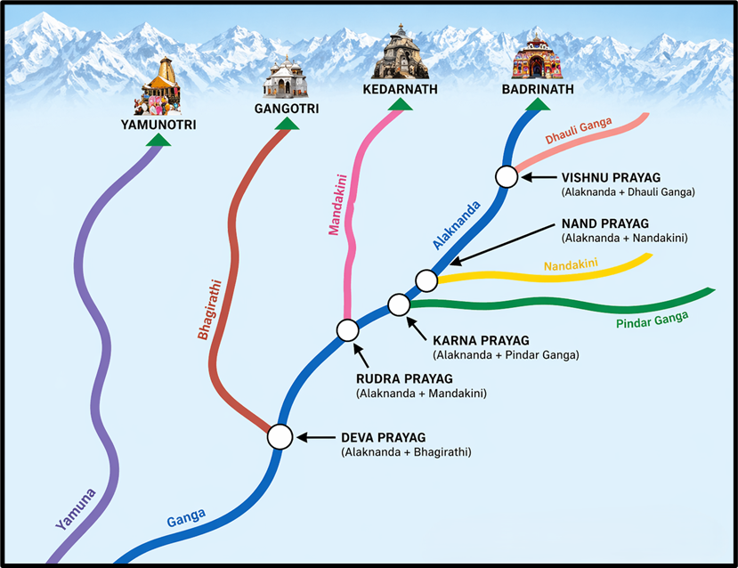
🏔️ The Origin – Birth of the Ganga
Just like any human has a place of birth, rivers too have a source. But Ganga has two “parents” before she gets her name.
- Bhagirathi originates from the Gangotri Glacier in Uttarkashi, Uttarakhand, at a height of 7,010 m.
(Remember the legend of King Bhagirath? He meditated to bring Ganga down to Earth to purify the ashes of his ancestors. That’s why it’s called Bhagirathi initially.) - On the other hand, Alaknanda—another major Himalayan river—meets Bhagirathi at Devprayag.
👉 From Devprayag, this combined river officially gets the name: Ganga.
The Sacred Confluences – Panch Prayag
Before Alaknanda meets Bhagirathi at Devprayag, it passes through five important confluences in the Himalayas, collectively known as Panch Prayag. These are not just geographical junctions but also reflect the structural and fluvial evolution of the Himalayan river system.
From upstream to downstream:
- Vishnuprayag – Alaknanda + Dhauliganga
- Nandprayag – Alaknanda + Nandakini
- Karnaprayag – Alaknanda + Pindar
- Rudraprayag – Alaknanda + Mandakini
- Devprayag – Alaknanda + Bhagirathi → Formation of Ganga
👉 These confluences show how multiple Himalayan tributaries merge to build the discharge and sediment load of the Ganga system.
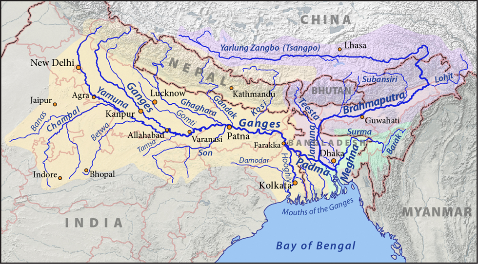
🏞️ The Journey of the Ganga – From Hills to the Sea
Now think of Ganga as a traveler:
- She debouches (emerges) into the plains at Haridwar.
- Moves across fertile Uttar Pradesh, where at Prayagraj, Yamuna joins her. This spot is the famous Triveni Sangam (with mythical Saraswati).
- She flows eastward across Bihar and Jharkhand.
- Near the Rajmahal Hills, she turns southeast.
- At Farakka (West Bengal), she splits:
- Bhagirathi-Hooghly in India
- Padma-Meghna in Bangladesh.
🌀 After this point, the name “Ganga” officially ends. But the legacy continues.
🌊 The Ganga-Brahmaputra Delta – World’s Largest Delta
When two mighty rivers—Ganga and Brahmaputra—meet before entering the sea, what do they create?
👉 A delta of 58,752 sq. km—the largest in the world.
It’s like two rivers forming a giant triangular landmass, full of swamps, estuaries, and mangroves (like the Sundarbans, home to Royal Bengal Tigers). During high tides, even marine water floods in. It’s fertile, but flood-prone.
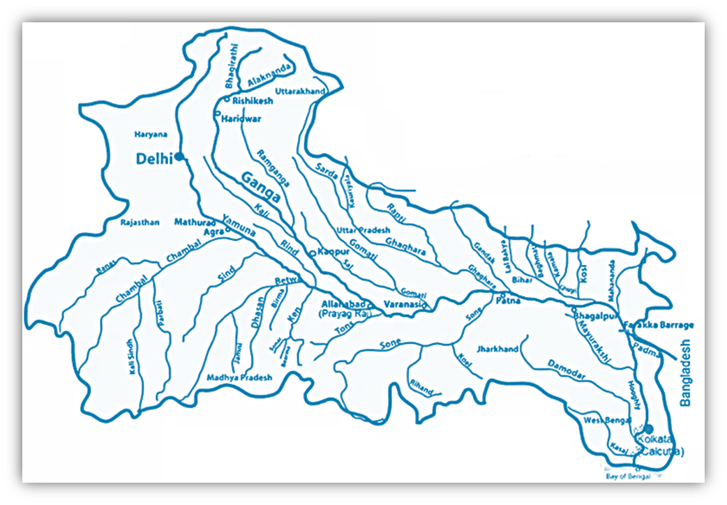
🧩 Tributaries of the Ganga – The Family Tree
Think of Ganga as a matriarch. But she has a vast family—some from the left, some from the right. These tributaries are her children, each with a story.
🔸 Left Bank Tributaries (From the Himalayas)
Remember: Left bank = left side if you’re facing downstream.
- Ramganga – Rises in Uttarakhand; joins near Kannauj.
- Ghaghra – From Tibet, enters through Nepal. Highly flood-prone.
- Kali (Sarda) – Border river between Nepal & Uttarakhand.
- Gandak – Originates near Tibet-Nepal border; joins at Hajipur.
- Burhi Gandak – From Sumesar hills; joins near Munger.
- Kosi – Formed by 7 Himalayan rivers. Joins near Kursela. Called ‘Sorrow of Bihar’ due to frequent floods.
🔹 Right Bank Tributaries (mostly from Peninsular India)
- Son – From Amarkantak Plateau. Joins at Patna.
- Damodar – From Chotanagpur Plateau. Once ‘Sorrow of Bengal’, now tamed by dams.
- Yamuna – From Yamunotri glacier on Bandarpunch peak. Longest tributary. Joins at Prayagraj.
- While it joins from the west, it is a Himalayan river, not peninsular.
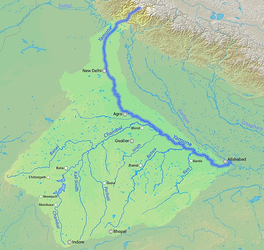
🌉 Yamuna River
While Ganga takes her eastern path, Yamuna flows like a shadow beside her, carving her own identity before finally meeting her sister at the Triveni Sangam in Prayagraj.
Let’s now unfold the journey of the Yamuna, her origins, key tributaries, and the grand finale where she merges with the Ganga.
🔷 Basic Overview
| Feature | Detail |
|---|---|
| Origin | Yamunotri Glacier, Bandarpunch Peak (Garhwal, Uttarakhand) |
| Elevation | Approx. 6,000 meters |
| Total Length | 1,376 km (from origin to confluence with Ganga at Prayagraj) |
| States Flowed Through | Uttarakhand, Himachal Pradesh, Haryana, Delhi, Uttar Pradesh |
| Confluence | Triveni Sangam, Prayagraj (with Ganga and mythical Saraswati) |
| Importance | Forms Yamuna-Ganga Doab – one of the most fertile plains in India |
🌄 From Glacier to Plains
- The Yamuna begins her journey in the Himalayas
- She cuts through the Nag Tibba, Mussoorie, and Shiwalik ranges—emerging from the hilly region near Tajewala.
- Her main partner in the upper Himalayan region is the Tons River—and here’s the fun fact:
💧 At the point where Tons meets Yamuna (near Kalsi), Tons actually brings twice the water as Yamuna herself!
🔀 Yamuna’s Tributaries – Her Supporting Network
Let’s divide the tributaries based on their origin:
🌊 Non-Peninsular Tributaries (from the Himalayas):
These are like her Himalayan siblings—young, swift, and seasonal.
| Non-Peninsular Tributary | Remarks |
|---|---|
| Tons | Largest, originates from Bandarpunch Glacier |
| Rishiganga | Short, fast-flowing |
| Uma | Seasonal, limited length |
| Hanuman Ganga | Mythologically significant |
| Hindon | Passes through western UP, joins near Noida |
🌾 Peninsular Tributaries (flow from central India into Yamuna):
These are her elder cousins—flowing from the peninsular plateau into the northern plains.
| Peninsular Tributary | Key Points |
|---|---|
| Chambal | Largest; infamous for deep ravines & legends of dacoits |
| Sind | Flows through MP and UP; joins Yamuna in Etawah |
| Betwa | Originates in Vindhyas; meets Yamuna near Hamirpur |
| Ken | Known for beautiful Raneh Falls; joins near Chilla (UP) |
🎯 These rivers mostly enter Yamuna between Agra and Prayagraj, enriching the Doab region with fertile silt.
📌 Geographical Significance
- The Yamuna-Ganga Doab is the fertile stretch between the Ganga and Yamuna rivers.
- Historically, this region hosted powerful empires—Mauryas, Guptas, Mughals—thanks to its fertility and water access.
Chambal River
- Origin: Janapao Hills, Vindhyan Range, Madhya Pradesh (~700 m elevation).
- Flows through: Malwa Plateau.
- Joins Yamuna: In Etawah district, Uttar Pradesh.
- Length: ~1,050 km.
Why important?
Chambal flows in a peculiar way—deep below its banks, due to heavy soil erosion caused by low rainfall. Over centuries, this created deep ravines—so sharp and chaotic that the region is called badland topography.
🧠 Badland = land so eroded it becomes agriculturally useless.
That’s why Chambal Valley was once known for dacoits—the terrain gave them natural hideouts.
Dams on Chambal
There are four major dams (from upstream to downstream):
- Gandhi Sagar Dam
- Rana Pratap Sagar Dam
- Jawahar Sagar Dam
- Kota Barrage
These dams generate hydroelectricity and irrigate fields—like putting locks on a wild gate to make it useful.
🌿 Keoladeo National Park, a famous bird sanctuary, gets water from this irrigation system.
Banas River
- Tributary of Chambal.
- Originates in the Aravalli Range.
- Joins Chambal near Sawai Madhopur.
It shows how even a tributary like Chambal has its own mini-river system.
Sind River
- Origin: Vidisha Plateau, Madhya Pradesh.
- Length: ~415 km.
- Joins Yamuna, enriching its flow.
Betwa River
- Origin: Bhopal district, Vindhyan Range.
- Joins Yamuna near Hamirpur.
- Dhasan is its major tributary.
Betwa has historical importance—flows through regions with Bundelkhand culture.
Ken River
- Origin: Barner Range, Madhya Pradesh.
- Joins Yamuna near Chila (in Uttar Pradesh).
- Famous for Raneh Falls and Ken Gharial Sanctuary.
Son and Damodar: Right Bank Tributaries of Ganga
Son River
- Origin: Amarkantak Plateau, close to Narmada’s source.
- Flows along the Kaimur Range.
- Joins Ganga near Danapur (Patna, Bihar).
Son is unique—flows on a rocky bed, so it has no meanders like typical rivers.
Its tributaries mostly join from the right bank, including: Johilla, Gopat, Rihand, Kanhar and North Koel
Damodar River
- Origin: Chotanagpur Plateau.
- Flows through a rift valley, rich in coal and minerals.
- Earlier called the “Sorrow of Bengal” due to devastating floods.
- Now controlled by dams and reservoirs.
- Joins Hugli (a distributary of Ganga), ~48 km below Kolkata.
Major Tributaries:
- Barakar (most important)
- Konar
- Bokaro
- Haharo
The Damodar Valley is called the “Ruhr of India”, just like Germany’s Ruhr Valley, due to dense industrialization and coal mining.
🌊Left Bank Tributaries of Ganga
These are like mighty brothers of Ganga, originating in the Himalayas or Trans-Himalayas, and bringing immense water and silt due to snowmelt and rainfall.
Ramganga River
- Origin: Garhwal, Uttarakhand
- Joins Ganga at Kannauj.
- Seasonal yet important in central UP.
Ghaghra River – Ganga’s Largest Left Bank Tributary
- Origin: Near Gurla Mandhata Peak, south of Manasarovar (Tibet).
- Called Karnali in Nepal.
- Major Tributaries:
- Sarda (Kali)
- Sarayu (Ayodhya is on its bank)
- Rapti
It is highly flood-prone, has a sandy bed, and changes course frequently—problematic for agriculture.
Kali / Sarda River
- Origin: Glaciers in Trans-Himalaya.
- Forms India-Nepal border.
- Called Sarda after entering plains.
- Joins Ghaghra.
Gandak River
- Origin: Near Tibet-Nepal border (7,620 m elevation).
- Receives many Himalayan tributaries:
- Kali Gandak
- Mayangadi
- Bari
- Trishuli
- Enters India at Tribeni.
- Joins Ganga at Hajipur (Bihar).
Burhi Gandak
- Origin: Sumesar Hills, India-Nepal border.
- Joins Ganga near Monghyr (Munger), Bihar.
Kosi River – Sorrow of Bihar
- Formed by seven streams from Eastern Nepal → called Sapt Kaushiki.
- Main channels: Tumar, Arun, Sun Kosi → merge at Triveni to form Kosi.
- Joins Ganga near Kursela.
Kosi is extremely unpredictable—due to silt deposition, its channel shifts frequently.
It has caused massive floods and converted fertile land into wasteland in north Bihar.
To control it:
- A barrage was built in 1965 at Hanuman Nagar (Nepal).
- Embankments were built jointly by India and Nepal.
💡 Important Facts to Remember:
- Total length of Ganga: 2,525 km (from Gangotri to Hugli’s mouth).
- Length of Yamuna: 1,376 km.
- The delta formed by Ganga-Brahmaputra is the largest in the world.
- Ganga is sacred but also was listed as 5th most polluted river in 2007.
- Home to endangered species like the Ganges River Dolphin.