
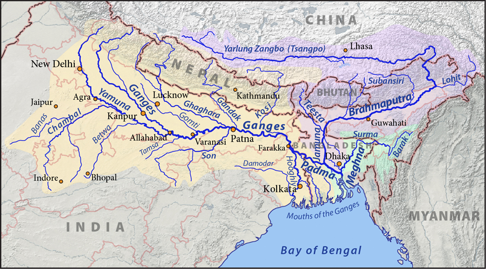
Brahmaputra River System
This river travels through multiple regions—Tibet, China, India, and Bangladesh—and is known by different names at different stages. But make no mistake—it’s the same water flowing throughout. And this journey isn’t just geographical; it’s geological, cultural, and economic.
🏔️ Origin of the Brahmaputra – In Tibet (Tsangpo)
- Source: Chemayungdung Glacier in the Kailas Range, at an elevation of about 5,150 metres.
- Fun fact: The Indus, Sutlej, and Brahmaputra—three mighty rivers—begin their journey in close proximity. They are like classmates who later take different careers😊
- The river in Tibet is called Tsangpo, meaning “The Purifier”. Spiritually rich and geographically majestic, it flows gently through southern Tibet.
Geographical Setting:
- The Tsangpo flows eastward for 1,800 km through a depression called the Indus-Tsangpo Structural Zone, which lies between the Great Himalayas in the south and the Kailas Range in the north.
- Despite its high altitude, the slope is gentle—so the river remains calm and navigable, like a peaceful monk in a high Himalayan monastery.
🌊 The Great Bend – Namcha Barwa (Syntaxial Bend)
As the river approaches the eastern limit of the Himalayas, it makes a dramatic southward turn near a mountain called Namcha Barwa (7,756 m). This is called the Syntaxial Bend—a sharp turn in geological structure, where the Himalayas twist and the river slices through them.
It then enters Arunachal Pradesh through the deep Dihang or Siang Gorge.
🌄 In Arunachal Pradesh and Assam – Dihang to Brahmaputra
- Upon entering India:
- First called Siong.
- Then known as Dihang near Sadiya (northeast Assam).
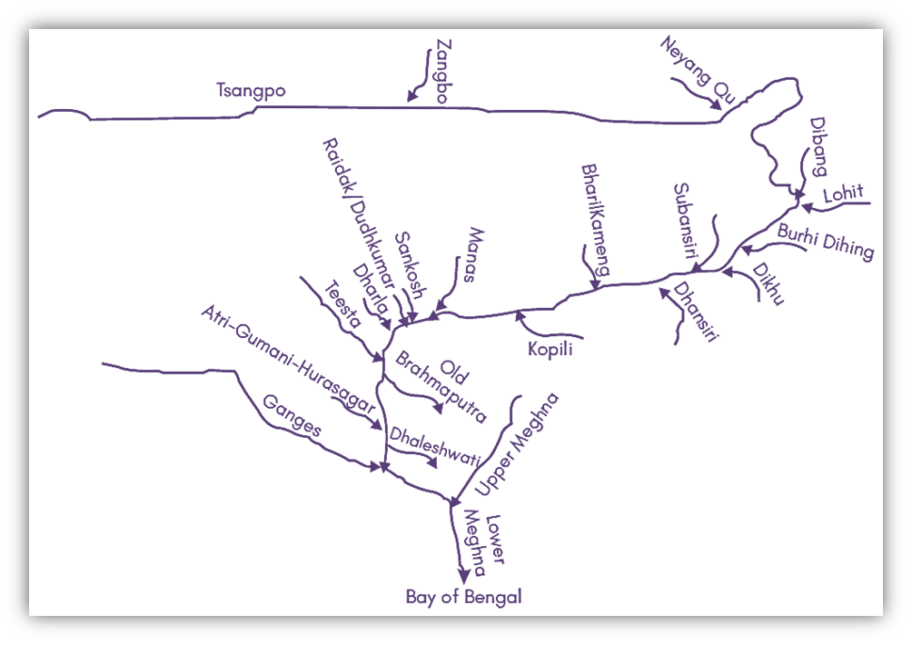
- After joining with tributaries like Dibang and Lohit, it becomes the mighty Brahmaputra.
Major Right Bank Tributaries:
- Kameng
- Manas
- Teesta (earlier a tributary of the Ganga before 1787 floods)
- Subansiri
- Jaldhaka
- Raidak
Major Left Bank Tributaries:
- Dibang
- Lohit
- Dhansiri
- Kolong
Now, let’s briefly explore the major tributaries — one by one.
Subansiri River
- Known as the “Gold River” — the name comes from “Suban” meaning gold.
- It is the largest tributary of the Brahmaputra.
- It originates in the mountains of Tibet and flows through Arunachal Pradesh before joining the Brahmaputra in Assam.
- It is an antecedent river, meaning it existed before the uplift of the Himalayas and continued to cut its course through rising mountains.
This makes it not only hydrologically important but also geologically significant.
Kameng River (Jiabharali)
- The Kameng (also known as Jiabharali) originates in a glacial lake near Nyegi Kangsang, one of the highest peaks in Arunachal Pradesh.
- It flows southwest through the Bhalukpong region and joins the Brahmaputra near Tezpur.
- Its upper course is rugged and mountainous, while its lower course provides fertile alluvial plains.
Dhansiri River
- The Dhansiri River rises in Nagaland, below the Laishiang Peak.
- From its source up to Dimapur, it forms the boundary between Assam and Nagaland.
- It’s a significant tributary, both hydrologically and politically, as it delineates state borders and sustains agriculture along its banks.
Manas River
- The Manas is a transboundary river, flowing through Bhutan and India.
- It descends from the Himalayan foothills, forming a rich alluvial fan and joins the Brahmaputra near Jogighopa in Assam.
This river is ecologically significant —
- The Royal Manas National Park (in Bhutan) and the Manas National Park (in Assam) lie along its banks.
- The Manas National Park is also a UNESCO World Heritage Site, famous for tigers, elephants, and biodiversity.
Kopili River
- The Kopili is a left-bank tributary, originating in the Saipong Reserve Forest of Meghalaya.
- It flows northward into Assam, cutting through a hilly terrain and finally joining the Brahmaputra.
- It is a key source of hydroelectricity in Assam — the Kopili Hydroelectric Project is based on this river.
Teesta River
- The Teesta is another transboundary river, originating near Chunthang in Sikkim, from the glaciers of the Himalayas.
- It flows through North Bengal — where it is the largest river — and eventually joins the Jamuna River (the name for the Brahmaputra in Bangladesh).
- The river plays a crucial role in Sikkim and West Bengal’s irrigation and hydropower, but it’s also a point of water-sharing tension between India and Bangladesh.
🌊 Barak River System
Now, let’s move a bit south of the Brahmaputra Valley — to the Barak River System, which drains the southern part of Assam and parts of Manipur, Mizoram, Tripura, and Meghalaya.
🗺️ Extent
- The Barak Basin covers parts of India, Bangladesh, and Myanmar.
- In India, it spreads across Meghalaya, Manipur, Mizoram, Assam, Tripura, and Nagaland — together accounting for about 1.38% of India’s total geographical area.
🌄 Boundaries
- North – Barail Range
- East – Naga and Lushai Hills
- South – Mizo Hills
- West – Bangladesh
The Barail Range acts as a natural divide, separating the Barak Basin from the Brahmaputra Basin.
🌊 Origin and Course
- The Barak River rises from the Manipur Hills, then flows along the Nagaland–Manipur border, and enters Assam.
- It then flows into Bangladesh, where it splits into two branches:
- Surma, and
- Kushiyara.
- Later, these two merge again and form the Meghna River, which finally receives the combined flow of the Ganga (Padma) and Brahmaputra (Jamuna) before draining into the Bay of Bengal.
Thus, the Barak system acts as the southern counterpart of the Brahmaputra system, eventually merging with it in Bangladesh.
🏞️ Tributaries of the Barak River
Right Bank Tributaries:
Jiri, Chiri, Modhura, Jatinga, Harang, Kalain, Gumra
Left Bank Tributaries:
Dhaleswari, Singla, Longai, Sonai, Katakhal
⚡ Hydroelectric Projects (HEPs) on the Brahmaputra Basin
Because of its high gradient, youthful rivers, and abundant rainfall, the Brahmaputra Basin has enormous hydropower potential.
Let’s list the major ones:
| Name of Project | State | River |
|---|---|---|
| Kopili HEP | Assam | Kopili & Umrong |
| Karbi Langpi HEP | Assam | Borapani |
| Lower Subansiri HEP | Arunachal Pradesh, Assam | Subansiri |
| Ranganadi HEP | Arunachal Pradesh | Ranganadi |
| Kameng HEP | Arunachal Pradesh | Bichom & Tenga |
| Teesta-V HEP | Sikkim | Teesta |
| Teesta Low Dam Stage-III HEP | West Bengal | Teesta |
| Umiam-III HEP | Meghalaya | Umium & Umtru |
These projects not only generate electricity but also play a role in irrigation and flood control, though they often raise ecological and inter-state concerns (e.g., Lower Subansiri controversy between Assam and Arunachal Pradesh).
🏞️ Brahmaputra in Assam – A Braided, Shifting River
The Brahmaputra becomes wide and unstable, with features like:
- Braided Channels: Like multiple threads of a rope running side by side, the river splits into various channels due to heavy silt.
- Meandering: Frequent twisting and turning due to loose soil and variable flow.
- Islands: Including Majuli—the world’s largest river island, 90 km long and up to 20 km wide.
💡 This is where the river’s power becomes a double-edged sword. On one hand, it brings fertile soil and supports navigation; on the other, it causes disastrous floods during monsoons, earning the nickname—“River of Sorrow”.
🚢 Navigability and Transport
- Navigable for 1,384 km from its mouth to Dibrugarh.
- Serves as a key inland water transport route, especially in Assam and northern Bangladesh.
🌐 Brahmaputra in Bangladesh – From Jamuna to Meghna
Once the river enters Bangladesh near Dhubri, it undergoes another transformation:
- Known as Jamuna River (not to be confused with Yamuna).
- Flows for 270 km, and joins the Ganga at Goalundo.
- This combined flow is called the Padma River.
- Further downstream, Padma meets Meghna (another river from Assam hills).
- From this confluence, the river is called Meghna, which forms a broad estuary and finally flows into the Bay of Bengal.
📌 Names of the River Across Regions
| Region | Name of River |
|---|---|
| Tibet | Tsangpo |
| China | Yarlung Zangbo, Jiangin |
| Arunachal Pradesh | Siong / Dihang |
| Assam Valley | Brahmaputra |
| Bangladesh | Jamuna → Padma → Meghna |
🎯 Key Takeaways
- Multinational River: The Brahmaputra flows through Tibet (China), India, and Bangladesh.
- Name Changes Reflect Geography: Different regions give it different names, showing its cultural and political diversity.
- Geological Drama: The Syntaxial Bend near Namcha Barwa is one of the most geologically active and dramatic river turns in the world.
- Floods and Fertility: A boon and bane—floods cause suffering but also support agriculture through fertile alluvium.
- Strategic and Economic Lifeline: A vital waterway for transport, agriculture, and hydroelectric power.