
Mann’s Model of Urban Structure – A Hybrid Approach (1965)
“When geography meets sociology and climate, urban land use becomes a story of direction, class, and the wind.”
Did you understand this statement? If not, I am sure you will get it at the end of this section. Well let’s start the story:
See, in 1965, Peter Mann, a British geographer, introduced a model that synthesizes the earlier theories — Burgess’ concentric model and Hoyt’s sector model — but also adapts them to British urban reality, with climatic considerations.
🧠 Core Idea of Mann’s Model
Unlike purely economic models, Mann added a climatic dimension and social class element to explain why cities develop the way they do — especially in Britain.
This makes his model more realistic, multi-dimensional, and context-specific.
🔍 Key Features of Mann’s Model
1️⃣ Combination of Models
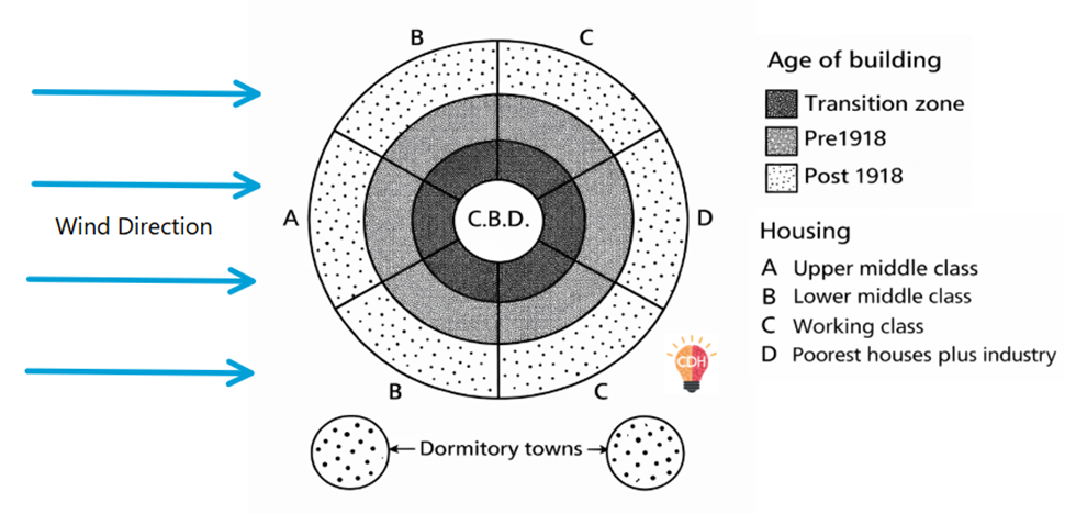
- Concentric elements → Recognizes inner CBD, transition zone, residential zones forming in rings.
- Sector elements → Different land use and class-based housing grow in specific directions, often along transport routes.
- Climatic aspect → Wind direction plays a vital role in shaping residential preferences.
2️⃣ Climatic Consideration – Wind from the West
- Prevailing westerly winds in the UK mean that pollution and smoke from industrial zones (usually in the east) blow away from the western parts.
- Hence, high-class residential areas develop on the western fringes, enjoying cleaner air and better living conditions.
🏡 “The rich live upwind, the poor live downwind.”
3️⃣ Zonal and Sectoral Details in the Model
| Zone / Sector | Characteristics |
|---|---|
| CBD | Core business, commercial, administrative area |
| Transition Zone | Mixed land use – deteriorating housing, some industries |
| Sector A | Large old houses, may be subdivided into flats |
| Sector B | Larger houses, near industries, often lower-middle class |
| Sectors C & D | Terraced small houses – typical working-class housing |
| Working-Class Areas | Near industrial sector for easy commuting |
| Post-1918 Housing | On the urban fringe, includes new suburbs and dormitory towns |
| Council Estates | Government-built housing for low-income groups, near industry |
| Best Residential Zone | Western fringe – upper-class residents live upwind, away from pollution |
🧱 Innovative Aspects of Mann’s Model
| Feature | Explanation |
|---|---|
| Inclusion of Climate | One of the earliest model to factor in wind direction in land use. |
| Sociological Realism | Reflects class-based residential patterns seen in UK cities. |
| Hybrid Approach | Combines Burgess’ rings and Hoyt’s wedges. |
| Post-war Urban Development | Includes post-1918 housing, suburban growth, and commuter zones. |
📉 Criticism of Mann’s Model
| Limitation | Explanation |
|---|---|
| Context-specific | Tailored for British cities – not universally applicable, especially to developing countries. |
| Monocentric Bias | Assumes a single CBD, doesn’t account for multiple nuclei in modern cities. |
| Temporal Relevance | Best suited for mid-20th century cities, less adaptable to 21st-century urban sprawl. |
✅ Conclusion
“Mann’s Model reminds us that geography isn’t just space — it’s also wind, class, and history.”
P. Mann’s Model is a valuable framework to understand how natural factors (like wind) and social elements (like class) interact with economic forces in shaping urban space. It provides a balanced, hybrid approach, making it a must-mention model for UPSC Geography Optional answers on urban settlement theories.