
Jet Streams
Imagine you’re looking at the Earth from space. In the upper part of the troposphere — that is, around 7.5 to 14 km above the surface — there are narrow belts of very fast-moving winds. These are Jet Streams.
These winds aren’t spread everywhere like monsoon winds; rather, they are like air highways — strong, narrow, and circumpolar (circling the globe near the poles), with a width of a few hundred kilometers.
According to the World Meteorological Organization (WMO), a jet stream is:
A strong, narrow current in the upper troposphere or lower stratosphere, concentrated along a horizontal axis, with strong vertical and lateral wind shear, and featuring one or more velocity maxima.
How were Jet Streams discovered?
During World War II, American fighter planes flying from east to west (towards Japan) suddenly experienced a slowdown in speed. But when they returned (west to east), their speed increased dramatically. Scientists found the reason — in the upper troposphere, there was a strong westerly air current moving from west to east. This “fast-moving air river” resisted motion in one direction and aided it in the other. Thus, the concept of Jet Streams was officially recognized.
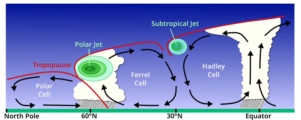
In exam you can draw this following simple diagram to illustrate Jet streams
Properties of Jet Streams
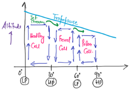
- Direction and Location – Always flow from west to east in a narrow belt, found between poles and about 20° latitude in both hemispheres, at heights of 7.5–14 km.
- Dimensions –
- Length: Thousands of kilometers
- Width: Few hundred kilometers
- Depth: Around 2–4 km
- Latitudinal Range – Present between poles and 20° latitude, circling the Earth in a circum-polar fashion.
- Wind Shear –
- Vertical: 18–36 km/hour difference in speed above/below the jet
- Lateral: 18 km/hour difference across the sides
- Minimum speed: 108 km/hour
- Path – Wavy and meandering, not straight.
- Seasonal Variation –
- Winter: Stronger (wind speeds up to 480 km/hour)
- Summer: Slower, as the belt shifts northward and becomes narrower.
- Seasonal Shift – Extends to around 20° latitude in winter, but shifts northward and contracts in summer.
Why Do Jet Streams Move from West to East?
The west-to-east movement of jet streams is primarily due to:
- Earth’s Rotation (Coriolis Effect)
- As air moves toward the poles, the Coriolis force deflects it to the right in the Northern Hemisphere and to the left in the Southern Hemisphere.
- This causes the winds to move west to east instead of north-south.
- Temperature Gradient and Pressure Differences
- Jet streams form at the boundaries of air masses (e.g., polar cold air meeting warm tropical air).
- The sharp pressure difference creates fast-moving winds along these boundaries, which the Coriolis force steers from west to east.
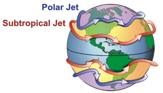
Types of Jet Streams
Jet streams aren’t just one uniform belt — there are five main types based on location and cause:
- Polar Front Jet Streams
- Location: Above 40–60° latitudes where cold polar air meets warm tropical air.
- Cause: Steep thermal gradient between two contrasting air masses.
- Direction: West to east, irregular flow.
- Subtropical Westerly Jet Streams (STWJ)
- Location: Above 30°–35° latitudes (poleward limit of Hadley Cell).
- Direction: West to east, more regular than polar front jets.
- Tropical Easterly Jet Streams (TEJ)
- Location: Above surface easterly trade winds over India and Africa in summer.
- Cause: Intense heating of Tibetan Plateau.
- Significance: Plays a vital role in Indian monsoon onset and behavior.
- Polar Night Jet Streams(Stratospheric Subpolar Jets)
- Location: Around poles in the stratosphere at ~30 km altitude.
- Season: Winter, due to steep temperature gradient in the polar stratosphere.
- Nature: Strong westerlies in winter, weaken in summer and may turn easterly.
- Local Jet Streams
- Cause: Local thermal or dynamic conditions.
- Significance: Limited to small areas, no major global role.
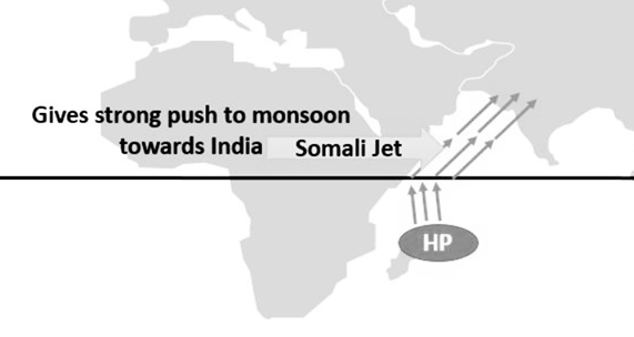
Special Case: Somali Jet Stream
- A temporary jet stream that significantly impacts the Indian monsoon.
- Originates near Mauritius and Madagascar, flows over Kenya and Somalia, and strengthens the Southwest Monsoon.
So, until this we have read: Jet streams are like invisible highways in the upper atmosphere that guide weather systems, influence flight paths, and play a decisive role in phenomena like monsoons. Understanding their position, speed, and seasonal shifts helps us connect large-scale atmospheric circulation to local weather events. Let’s move on:
Index Cycles of Jet Streams
Let’s begin with the basic cause:
- The strength and position of jet streams are directly linked to the temperature gradient between the equator and the poles.
- In winter, over the Arctic, cold, heavy air sinks → creating high pressure at the surface.
- Above it, in the upper troposphere, air rises away (because colder air below suppresses it), creating low pressure.
- This difference sets up a cyclonic circulation high in the atmosphere, moving from west to east — the circumpolar whirl.
- The equatorward extension of this whirl is what we call the Jet Stream.
Now, because the polar whirl strengthens in winter, the jet stream extends southward — even down to 20°N in the Northern Hemisphere. Over time, the jet stream’s path changes from almost straight to highly wavy — these waves are Rossby Waves.
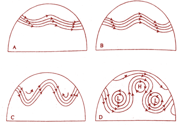
The process from straight → wavy → extreme meandering happens in four stages, called the Index Cycle:
First Stage
- Jet stream lies close to the poles.
- Separates cold polar air (north) and warm westerlies (south).
- Path is almost straight (west → east).
- Pressure gradient is steep across the stream, producing a high zonal index.
- Rossby waves have not developed yet.
Second Stage
- The straight path begins to bend slightly → Rossby waves start forming.
- Amplitude (height of waves) increases over time.
- Jet stream shifts equatorward.
- Pressure gradient is now north–south.
Third Stage
- Fully developed meandering, jet stream reaches near 20° latitude.
- Pressure gradient shifts to east–west.
- Cold polar air moves towards the equator; warm tropical air pushes towards the poles.
Fourth Stage
- Meanders become so deep that loops cut off from the main stream.
- These cut-off sections form independent cyclonic and anticyclonic circulations:
- Cut-off low → cyclonic pattern (south of main jet)
- Cut-off high → anticyclonic pattern (north of main jet)
- These patterns block the west-to-east flow of the main jet.
Significance of Jet Streams
Jet streams aren’t just passive winds — they’re powerful atmospheric directors that influence weather, climate, and even global pollution transport.
- Link to Temperate Cyclones
- When a jet stream sits above a mid-latitude cyclone, it strengthens the cyclone.
- This means more storm activity and higher-than-normal precipitation.
- Impact on Local Weather
- By influencing the movement of cyclones and anticyclones at the surface, jet streams cause day-to-day weather fluctuations.
- Convergence and Divergence in Upper Troposphere
- Convergence → air piles up aloft → creates upper air anticyclones.
- Divergence → air spreads out aloft → triggers cyclones below (due to rising air).
- Vertical Air Circulation and Mixing
- In cyclonic patterns → air moves upward.
- In anticyclonic patterns → air moves downward.
- This movement accelerates mixing between troposphere and stratosphere, transporting even anthropogenic pollutants upward.
- Influence on South Asian Monsoon
- The position and strength of certain jet streams, especially the Subtropical Westerly Jet and Tropical Easterly Jet, play a decisive role in the onset, intensity, and withdrawal of the Indian monsoon.
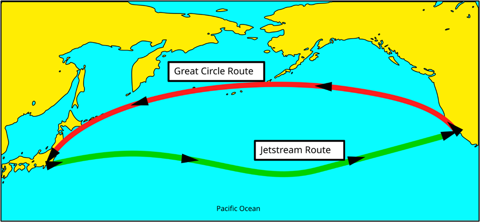
- Air Travel Impact:
- Airlines use jet streams for faster eastward flights, reducing fuel consumption.
- Conversely, flying against jet streams (westward) requires more fuel and time.
💡 To remember for UPSC Mains – Jet streams link global temperature gradients to regional weather events. The Index Cycle explains why their paths change seasonally, while their significance connects them to cyclones, pollution transport, and monsoons — a classic static-current affairs integration point.
Why Do Rossby Waves Form?
To understand Rossby waves, we need to recall an important concept—angular momentum conservation.
- Earth’s Rotation Effect:
- As air moves poleward, its radial distance (r) from Earth’s axis decreases, just like a figure skater pulling their arms in to spin faster.
- To conserve angular momentum (L = Iω = mr²ω), the air current starts taking a meandering path instead of moving straight.
- Meandering Becomes More Pronounced Near the Poles:
- Closer to the poles, the effect becomes more intense, making the winds curve more sharply.
- Sometimes, the meandering path stretches deep into the low latitudes, influencing tropical weather patterns.
Impact on Mid-Latitude Weather (Especially British-Type Climate)
Rossby waves are the primary reason for the climatic instability in mid-latitude regions such as Western Europe (Britain).
- When the waves are gentle: The westerlies bring steady, moist, oceanic air, leading to a mild and rainy climate.
- When the waves become extreme: Cold polar air plunges southward, or warm tropical air moves northward, leading to stormy or unusually dry conditions.
This is why weather in regions like the UK is highly unpredictable—Rossby waves are constantly shifting, altering pressure patterns, and changing wind directions.
4 Comments