
Other Important Geographical Features of North America
Please note that major physical features of North American Continent has already been discussed here
🟡 The Great Plains – The Breadbasket of North America
If you carefully look at physical map of North America you may observer, a giant semicircular plateau of grassland, stretching from Texas in the south all the way up to the Arctic Ocean—this is the Great Plains.
🧭 Location:
- Extends from the Rio Grande in the south to the Mackenzie River delta in the north.
- Bounded by:
- Rockies (West),
- Interior Lowlands and Canadian Shield (East).
- Covers 10 U.S. states and 3 Canadian provinces: Manitoba, Saskatchewan, Alberta.
- Occupies ~1/3rd of USA’s land area.
🏞️ Terrain:
- Contrary to popular belief, it’s not uniformly flat.
- Llano Estacado (Staked Plains, Texas) – extremely flat.
- Judith Mountains (Montana) – small mountain outcrops rise 1,500–2,000 ft above the plains.
💧 Drainage:
- In the USA:
- Rivers: Missouri (with tributaries like Yellowstone, Platte, Kansas), Red River, Arkansas, and Rio Grande.
- In Canada:
- Main river: Saskatchewan River and its tributaries.
The Great Plains is not just a geographical term—it is also a climatic and economic region, crucial for agriculture, cattle ranching, and energy resources (like shale gas).
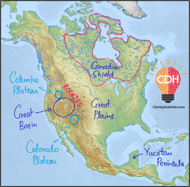
🟤 The Great Basin – The Bowl of the American West
Now shift your attention to a unique physiographic feature: the Great Basin. You can see a series of rugged mountains enclosing vast closed valleys—a basin without an outlet to the sea.
📌 Location:
- Lies between:
- Sierra Nevada (West),
- Wasatch Mountains (East),
- Columbia Plateau (North),
- Mojave Desert (South).
🌵 Physical Characteristics:
- Part of the North American Desert system along with Sonoran, Chihuahuan, and Mojave deserts.
- Features alternating mountain ranges and valleys (a horst and graben structure).
💧 Internal Drainage:
- Water does not reach the ocean.
- Example: Humboldt River (Nevada) ends in the Humboldt Sink, a closed basin.
🧠 Insight: This is a classic case of an endorheic basin, where the hydrological cycle is complete within the basin—a significant concept in geomorphology.
🧱 Canadian Shield – The Ancient Core
Now let’s enter deep geological time. The Canadian Shield —a massive expanse of exposed Precambrian rock.
🗺️ Extent:
- Covers about 8 million sq. km across:
- Eastern, Central, and Northwestern Canada,
- Parts of Greenland,
- Northern U.S. states: Minnesota, Wisconsin, Michigan, New York.
🧬 Geological Features:
- Made of ancient crystalline rocks (igneous and metamorphic).
- Shaped over billions of years through:
- Uplift,
- Orogeny (mountain-building),
- Erosion.
🪨 Why important? It’s a storehouse of minerals—nickel, copper, gold, and uranium—and forms the backbone of Canadian economy.
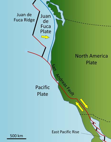
🟠 San Andreas Fault – The Sliding Plates
It is a transform plate boundary—where two tectonic plates slide past each other horizontally.
🌍 Location:
- Between the Pacific Plate and North American Plate.
- Runs through California, from Cape Mendocino to the Mexican border.
🏙️ Plate Placement:
- San Diego & Los Angeles – on Pacific Plate.
- San Francisco & Sacramento – on North American Plate.
🔥 Earthquake Zone:
- Famously caused the 1906 San Francisco Earthquake.
- Visible Features:
- Carrizo Plain and Olema Trough: Scarps and pressure ridges.
- Sometimes hidden under alluvium or vegetation.
🧠 Concept: Transform boundaries are zones of shearing motion, unlike convergent (collision) or divergent (spreading) boundaries.
🗾 Dependent/Overseas Territories in North America
Colonial legacy still echoes in North America through several overseas and dependent territories, belonging to European powers and the USA.
| Country | Territories |
|---|---|
| UK | Anguilla, Bermuda, British Virgin Islands, Cayman Islands, Montserrat, Turks & Caicos |
| France | Guadeloupe, Martinique, Saint Barthélemy, Saint Martin, Saint Pierre and Miquelon |
| Netherlands | Caribbean Netherlands, Sint Maarten |
| USA | Puerto Rico, U.S. Virgin Islands |
| Denmark | Greenland |
🧠 These are often strategically located in the Caribbean and North Atlantic, serving naval, economic, and geopolitical functions.
🟢 Central America – The Isthmus of Diversity
Central America is the bridge between North and South America—narrow but extremely diverse.
🌎 Geography:
- Includes seven countries:
- Belize, Guatemala, El Salvador, Honduras, Nicaragua, Costa Rica, Panama
- Forms part of the Mesoamerican biodiversity hotspot.
- About 80% is hilly or mountainous.
- Features humid lowlands and coastal swamps.
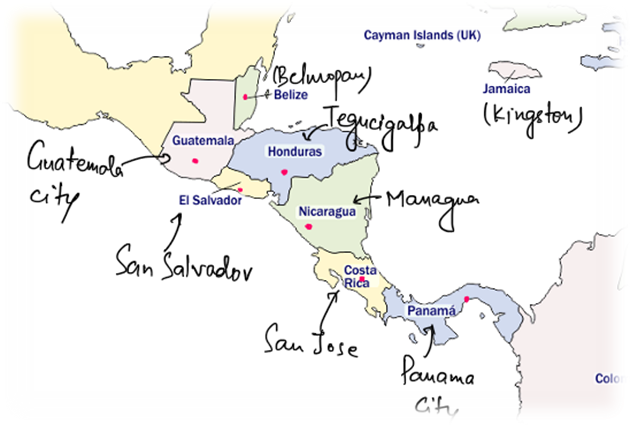
🧬 Why important?
- It’s not just a land bridge for species, but also a corridor of cultures, migration, and tectonic activity.
🔺 Yucatan Peninsula – Land of the Maya
Finally, let’s zoom into the Yucatan Peninsula, a unique limestone projection into the Gulf of Mexico and Caribbean Sea.
📌 Location:
- Includes three Mexican states:
- Campeche, Quintana Roo, Yucatan.
- Also extends into Belize and Guatemala.
🪨 Geology:
- Made primarily of porous limestone from coral rock.
- Features sinkholes (cenotes) and caverns due to chemical weathering.
🏛️ Cultural Significance:
- Mayan civilization thrived here.
- They built cities and ceremonial centres over this limestone base.
🧠 Key Concept: The Yucatan is a karst landscape, rich in archaeological, cultural, and hydrogeological significance.
3 Comments