
Tsunami Case Study and Preparedness
2004 Indian Ocean Tsunami
Background of the Disaster
- Date: 26th December 2004.
- Cause: A megathrust earthquake (9.0 Richter scale) near the western boundary of Sumatra.
- Impact: Triggered a series of massive tsunami waves across the Indian Ocean, causing unprecedented devastation.
👉 This was one of the deadliest natural disasters in modern history.
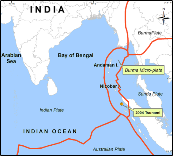
Plate Tectonics – The Trigger
- The Indian Plate was subducting under the Burma Plate.
- Due to stress buildup, there was a sudden rupture of the sea floor:
- Ocean floor displaced by 10–20 metres.
- Tilted downward, creating a massive gap.
- Water rushed in to fill this gap → withdrawal of sea water from the coastlines (classic tsunami sign).
- Then, water mass surged back violently → the tsunami waves.
👉 Mechanism = textbook example of subduction zone tsunami.
Tsunami Waves – The Deadly Journey
- Speed in deep ocean: ~800 kmph (like a jet aircraft!).
- Washed away entire islands in the Indian Ocean.
- Indira Point (southernmost tip of India, Andaman & Nicobar) got submerged permanently.
- As waves moved outward:
- Wavelength decreased with shallower waters.
- Speed dropped from 700–900 kmph to less than 70 kmph near coasts.
- But due to shoaling, wave height increased, causing maximum destruction.
- In India:
- Tsunami waves penetrated 3 km inland in places.
- More than 10,000 people killed.
- Worst-affected: Andhra Pradesh, Tamil Nadu, Kerala, Puducherry, Andaman & Nicobar Islands.
Shifts in Geography
This part is fascinating — the disaster was so massive it altered Earth’s physical parameters:
- Shift of Earth’s axis:
- North Pole shifted by 2.5 cm towards 145° East longitude.
- Rotation of Earth:
- Length of the day shortened by 2.68 microseconds.
- Slight change in Coriolis force, which influences global weather patterns.
- Regional Geography:
- Andaman & Nicobar Islands shifted ~1.25 m due to tectonic activity.
👉 This shows that earthquakes and tsunamis are not just local events; they can reshape geography at both local and global scales.
Tsunami Warning Systems
The Problem
- Earthquakes (the primary cause of tsunamis) cannot be predicted in advance.
- But — once an earthquake occurs under the sea, the movement of tsunami waves can be tracked.
- This allows a warning window of up to 3 hours before waves hit distant shores.
👉 Hence, tsunami early warning systems are critical.
Global Warning Systems
- The first organised system began in 1965, led by the National Oceanic and Atmospheric Administration (NOAA), USA.
- It covers Pacific Rim countries, since the Pacific Ocean is the most tsunami-prone region.
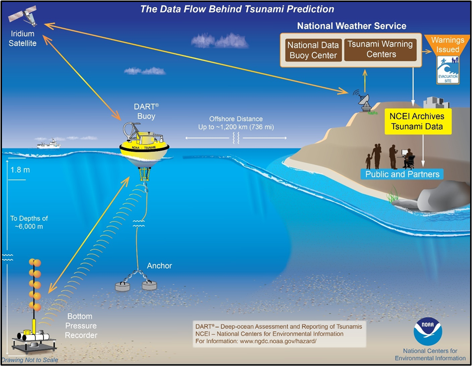
DART System (Deep Ocean Assessment and Reporting of Tsunamis)
- How it works:
- A sensitive pressure recorder is placed on the sea floor.
- If water pressure changes (indicating a wave passing), data is generated.
- This data goes to a surface buoy.
- From there, it is relayed via satellite.
- The Pacific Tsunami Warning Centre (PTWC), Hawaii processes the data and issues alerts.
👉 In short: Seafloor gauge → Buoy → Satellite → PTWC → Warnings issued.
India’s Preparedness
After the 2004 Indian Ocean tsunami, India realised the urgency of having its own system.
- DOARS (Deep Ocean Assessment and Reporting System) was set up in the Indian Ocean.
- National Tsunami Early Warning Centre (NTEWC) was inaugurated in 2007 at INCOIS, Hyderabad, under the Ministry of Earth Sciences.
Key features:
- Can detect earthquakes >6 magnitude in the Indian Ocean.
- Takes 10–30 minutes to process seismic data and issue warnings.
- Provides early warnings to India and neighbouring countries.
‘Tsunami Ready’ Programme
- This is a global initiative by UNESCO’s Intergovernmental Oceanographic Commission (IOC).
- Aim: To make coastal communities self-reliant, aware, and prepared for tsunami risks.
- In India, it is implemented by INCOIS.
India’s Role
- INCOIS runs the Indian Tsunami Early Warning Centre (ITEWC).
- ITEWC provides not only tsunami warnings, but also alerts for storm surges and high waves.
- UNESCO-IOC has designated ITEWC as a Regional Tsunami Service Provider (RTSP), meaning:
- It provides tsunami alerts not just for India, but for all Indian Ocean Rim countries.
One Comment