
Major Mountain Passes in the Himalayas
First thing to remember:
- Passes are natural depressions or gaps in mountain ranges, which allow movement across high mountains.
- In the Himalayas, most passes are snowbound in winters (Nov–Apr) because of heavy snowfall.
👉 This is why these passes have been historically important for trade, invasions, cultural exchanges, and in modern times — for roads, railways, and tunnels.
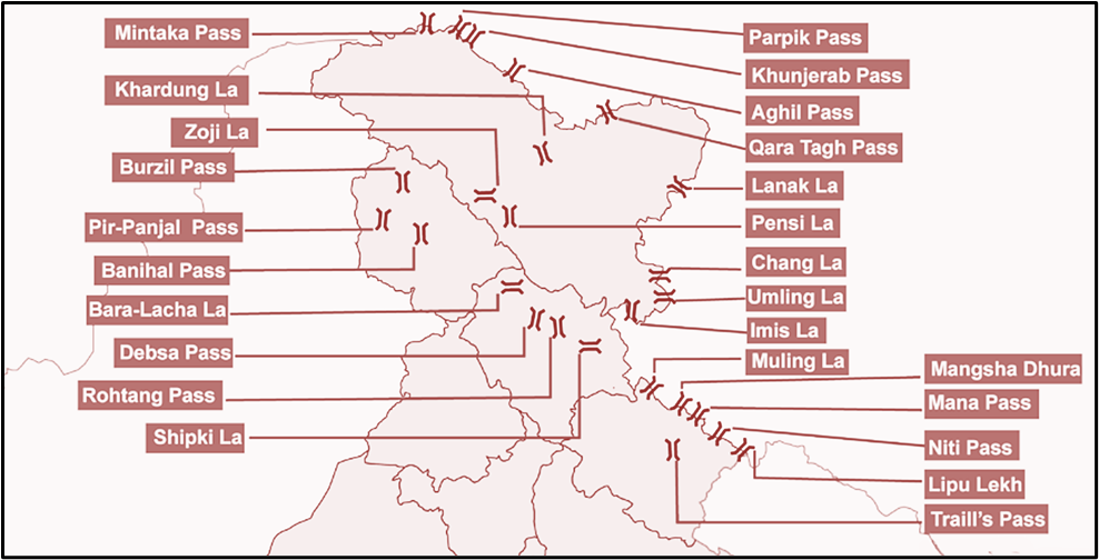
📍 Ladakh and Jammu & Kashmir Region
Let’s now move region by region. We start with Ladakh and J&K, because this is where maximum strategic passes exist due to proximity with China, Pakistan, and Central Asia.
1. Mintaka Pass (4,709 m)
- Location: Across Karakoram Range.
- Connects: Ladakh–China.
- Importance: Lies near the India–China–Afghanistan trijunction.
- Historical use: Part of the Silk Route.
👉 UPSC angle: Mintaka = Tri-junction (India-China-Afghanistan).
2. Parpik Pass (5,608 m)
- Location: Just east of Mintaka.
- Less used today, but was part of old trans-Karakoram routes.
3. Khunjerab Pass (4,693 m)
- Very important in the news.
- Why? The China–Pakistan Economic Corridor (CPEC) passes through this.
- Connects Gilgit-Baltistan (Pakistan-occupied Kashmir) with Xinjiang (China).
👉 UPSC angle: Strategic + CPEC.
4. Aghil Pass (4,978 m)
- Lies north of K2 Peak (the world’s second-highest mountain).
- Again, part of ancient caravan routes.
5. Qara Tag La (6,000 m) & Karakoram Pass (5,540 m)
- Both were branches of the Silk Route.
- Karakoram Pass in particular is very famous:
- Connects Ladakh with Tibet.
- Extremely cold, desolate, no vegetation.
- Used by caravans historically, but today it is militarily sensitive.
6. Lanak La (5,466 m)
- At the eastern edge of the Karakoram Range.
- Connects Ladakh with Tibet.
7. Imis La (5,795 m)
- On the Ladakh Range.
- Near Demchok sector (India–China sensitive area).
8. Umling La (5,882 m)
- Now a point of pride for India!
- Known as the world’s highest motorable road pass.
- Made headlines in recent years after BRO (Border Roads Organisation) constructed the road here.
👉 UPSC angle: World’s highest road pass.
9. Mig La (5,913 m) & Photi La (5,524 m)
- Close to Demchok again.
- New infrastructure: Likaru–Mig La–Fukche road is under construction. Once ready, it will become the highest motorable road in the world (even higher than Umling La).
10. Banihal Pass (2,832 m) – Pir Panjal Range
- Historic pass between Jammu and Srinagar.
- Earlier: Main road and railway passed over this pass.
- Then: Jawahar Tunnel (2,194 m) built in 1956.
- Recent: Banihal–Qazigund Road Tunnel (1,790 m, 2021) — part of National Highway 44 (Srinagar to Kanyakumari).
- Rail connectivity: 11 km tunnel (2013) between Banihal–Qazigund.
👉 UPSC angle: Banihal = Highway + Railway + Tunnels.
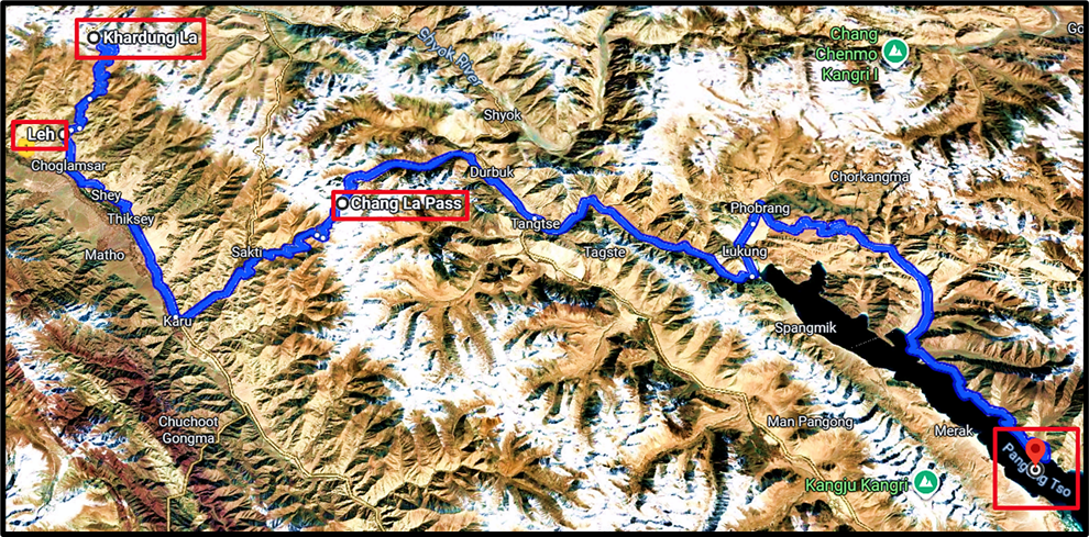
11. Chang La (5,391 m)
- Connects Leh with Pangong Lake and Aksai Chin.
- Lies between Indus and Shyok valleys.
- There is even a temple here — Chang-La Baba Temple.
12. Khardung La (5,359 m)
- One of the highest motorable passes in the world.
- Gateway to Nubra and Shyok Valleys.
- Historically, a caravan route from Leh to Kashgar (Central Asia).
13. Pir-Panjal Pass (3,490 m)
- Connects Kashmir Valley with Jammu.
- This was the shortest route, but got closed after Partition (1947).
14. Razdan Pass (3,556 m)
- Connects Kashmir with Gurez Valley.
15. Pensi La (4,400 m)
- Connects Zanskar Valley with Kargil.
16. Zoji La (3,528 m)
- A very famous pass.
- On Srinagar–Kargil–Leh route.
- Connects Kashmir Valley with Dras and Suru valleys.
- New projects:
- Zoji La Tunnel (14.2 km) under construction.
- Z-Morh Tunnel (6.5 km) also coming up.
👉 UPSC angle: Zoji La = Gateway to Ladakh.
17. Fotu (Photu) La (4,108 m) & Namika La (3,700 m)
- Two important passes between Leh and Kargil.
- Part of the National Highway 1 (Srinagar–Leh).
📍 Himachal Pradesh
Himachal is called the “Land of Valleys”, and naturally, it has several strategic passes connecting valleys internally, as well as with Ladakh and Tibet.
1. Bara Lacha La (4,850 m)
- Location: Lahaul & Spiti.
- National Highway: Manali–Leh Highway passes through it.
- Hydrology:
- Chandra River (Chenab tributary) originates from its southwest face.
- Bhaga River (Chenab tributary) originates from its northwest face.
- Developments:
- Tunnels under construction at Lachung La & Tanglang La to bypass Bara Lacha La.
👉 UPSC angle: Bara Lacha La = Manali–Leh Highway + Origin of Chandra & Bhaga.
2. Debsa Pass (5,360 m)
- Connects Kullu–Spiti.
- Offers a shorter and easier alternative to the traditional Pin–Parvati Pass.
3. Pin–Parvati Pass (5,319 m)
- Connects Parvati Valley (Kullu) with Pin Valley (Spiti).
- Historically used by shepherds of Spiti to graze sheep in the lush Parvati Valley.
4. Rohtang Pass (3,980 m)
- Perhaps the most famous pass in Himachal.
- Connects Kullu with Lahaul–Spiti.
- Location: On Leh–Manali Highway (NH-3), around 51 km from Manali.
- Strategic: On the eastern end of the Pir Panjal Range.
- Infrastructure:
- Atal Tunnel (9 km) built under it — provides all-weather connectivity between Manali and Lahaul.
👉 UPSC angle: Rohtang = Gateway to Lahaul-Spiti + Atal Tunnel.
5. Shingo La (5,091 m)
- Connects Lahaul (HP) with Zanskar (Ladakh).
- Part of the new Nimmu–Padum–Darcha Road project.
- After Shinku La Tunnel is completed, it will reduce the Manali–Kargil distance by 522 km.
👉 UPSC angle: Shingo La = Alternative all-weather route to Leh.
6. Shipki La (3,930 m)
- Location: Kinnaur district (near Shimla).
- Hydrology: The Sutlej River enters India through this pass.
- Strategic: One of India’s official border trading points with Tibet, along with Nathu La (Sikkim) & Lipulekh (Uttarakhand).
👉 UPSC angle: Shipki La = Entry point of Sutlej + Border trade.
📍 Uttarakhand
Unlike Himachal, most passes here are ancient Indo-Tibetan trade routes.
But after the 1962 Sino-Indian war, these were closed for regular trade.
Still, they remain strategically and culturally important.
1. Lipulekh Pass (5,115 m)
- Connects Uttarakhand with Tibet.
- Location: Near India–China–Nepal tri-junction.
- Importance: Used by Kailash–Mansarovar Yatra pilgrims.
👉 UPSC angle: Lipulekh = Tri-junction + Kailash Yatra.
2. Mana Pass (5,632 m)
- Location: North of Badrinath, inside Nanda Devi Biosphere Reserve.
- Among the highest vehicle-accessible passes in India.
- Strategic importance: Connects with Tibet.
3. Mangsha Dhura Pass (5,674 m)
- Another Kailash–Mansarovar route pass.
4. Niti Pass (5,800 m)
- One of the most ancient Indo-Tibetan trade routes.
- Lies in Chamoli district.
- Still remembered for its role in salt, wool, and grain trade.
5. Muling La (5,669 m)
- Location: North of Gangotri.
- Less famous today, but was used historically by traders and pilgrims.
📍 Sikkim
1. Nathu La (4,310 m)
- Location: Sikkim–Tibet border.
- Connects: Kalimpong (WB) & Gangtok (Sikkim) with Chumbi Valley (Tibet).
- Importance:
- Was part of Silk Route (Lhasa to India).
- Reopened for border trade in 2006 after being closed since 1962 war.
- Militarily sensitive — Chinese troops are right across the border.
👉 UPSC angle: Nathu La = Silk Route + Trade Route + Sino-Indian tension.
2. Jelep La (4,386 m)
- Location: Just 4 km south of Nathu La.
- Same connection: Kalimpong–Gangtok to Chumbi Valley.
- Was historically used by traders from Darjeeling to Lhasa
Doklam Plateau (near Doka La pass)
- Not exactly in Sikkim, but in western Bhutan, near Chumbi Valley.
- Importance:
- 2017 Doklam standoff — Chinese Army tried to extend a road in this area.
- India objected because Doklam is very close to the “Chicken’s Neck” Siliguri Corridor — our only land link to the northeast.
- Strategic: Whoever controls Doklam has a strategic advantage over Sikkim–Bhutan–Northeast India region.
👉 UPSC angle: Doklam = India-China-Bhutan strategic triangle.
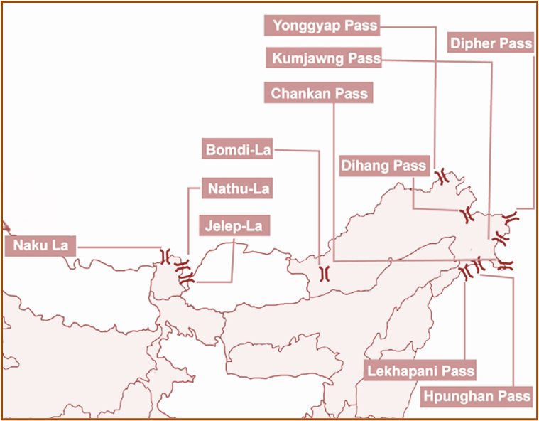
📍 Arunachal Pradesh
Arunachal is full of passes, because it lies on the Eastern Himalaya & Patkai ranges, bordering Tibet (China) and Myanmar.
1. Bom Di La (2,217 m)
- Location: Near Bomdila town (West Kameng).
- Connects: Itanagar–Tawang–Lhasa.
- Historically used by Buddhist monks and traders.
2. Bum La (4,600 m)
- Location: Near Tawang, close to India–Tibet–Bhutan tri-junction.
- Importance: Militarily sensitive; Indian and Chinese armies often meet here for flag meetings.
3. Sela Pass (4,170 m)
- Connects: Itanagar to Tawang.
- Location: Between Bom Di La and Bum La.
- Extremely scenic, with Sela Lake nearby.
- Key for movement of Indian Army to the Tawang sector.
👉 UPSC angle: Sela = lifeline for Tawang.
4. Dihang (Siang) Pass (4,590 m)
- Connects: Arunachal with Tibet.
- Important hydrology: The Tsangpo River (in Tibet) enters India as the Siang/Dihang here, before becoming the Brahmaputra.
5. Yonggyap Pass (3,962 m)
- Another less-famous route connecting Arunachal with Tibet.
6. Diphu (Dipher) Pass (4,587 m)
- Very important: Lies at the tri-junction of India–China–Myanmar.
- Strategic for all three countries.
Passes connecting Arunachal with Myanmar
- Kumjawng Pass (2,929 m)
- Hpungan Pass (3,072 m)
- Chaukan Pass (2,400 m)
- Pangsau Pass (1,136 m)
👉 These were ancient routes of migration and trade into Northeast India.
- Pangsau Pass is especially known as part of the World War II “Stilwell Road” (from Assam to Myanmar, built by the Allies).