Different Seasons in India
Winter Season in India (November to March)
Though the official “winter” is November to March, January is the peak winter month. The season is marked by cool temperatures, calm skies, and distinct regional variations.
🌞 Why Winter Happens (The Solar Logic)
- During winter, the Sun is to the south of the equator.
- As a result, India receives oblique solar rays, reducing heat intensity.
- Longer nights and shorter days → less insolation → drop in temperatures.
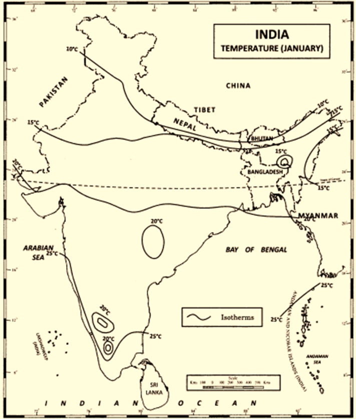
🌡️ Temperature Patterns
- The 20°C isotherm runs roughly parallel to the Tropic of Cancer:
- South of this line (like Kerala and Tamil Nadu): no true winter; temps hover around 25–30°C.
- North of this line: distinct winter with mean temperatures below 21°C.
- Dras Valley, J&K: Coldest place in India. Recorded –45°C in 1908.
- Diurnal range (difference between day and night temperatures) is:
- Very high in interior regions (like MP, Rajasthan)
- Low near coasts (due to sea’s moderating effect)
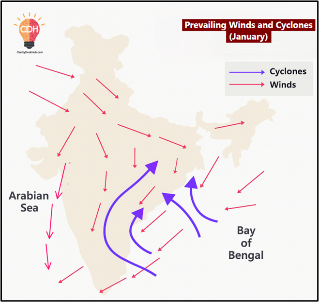
🧭 Air Pressure and Winds
- High-pressure system builds over north-west India (cold + dense air).
- Low pressure exists over southern peninsular India.
- So, surface winds blow from north-west to south-east.
- But since the pressure gradient is low, the wind speed is gentle.
- These are the North-East Trade Winds → dry and cool → retreating monsoon.
✅ Jet stream (STJ) over north India induces divergence, reinforcing high pressure.
🌧️ Precipitation and Rainfall Sources
🔹Western Disturbances (WDs)
- Originate in the Mediterranean Sea, guided by westerly jet streams.
- Enter India via Iran, Afghanistan, Pakistan → NW India.
- Cause:
- Light rain in Punjab, Haryana, Delhi, UP
- Snowfall in Himalayas (J&K, Himachal, Uttarakhand)
- Cold waves + fog after passage
“This is why wheat gets its ‘timely water’ in Punjab.”
🔹 North-East Monsoon Rainfall
- NE monsoon winds pick moisture from the Bay of Bengal.
- Bring winter rainfall to:
- Tamil Nadu
- South Andhra Pradesh
- South-East Karnataka and Kerala
Mostly in early November. Vital for Rabi crops in south India.
🔹 Tropical Cyclones (rare)
- Cyclone activity is lowest in this season.
- If any occur:
- Mostly affect Tamil Nadu and south AP in early November.
- Few cross into Arabian Sea, some drift westward.
🌫️ Fog and Cold Waves
- After western disturbances pass, cold waves sweep northern plains.
- Temperature drops 5–10°C below normal.
- Dense fog common in:
- Punjab
- Haryana
- UP
- Delhi
- This affects transport, agriculture, and public life.
Summer Season in India (March to June)
Also called the pre-monsoon period, this season marks the build-up to the southwest monsoon. It’s a time of extreme heat, local wind systems, thunderstorms, and dynamic weather changes across regions.
🌞 Why It Gets So Hot (Solar & Geographic Reasoning)
- Due to the northward apparent movement of the Sun (towards Tropic of Cancer), India receives high insolation.
- Land heats faster than water, and interiors get hotter due to continentality.
- Southern India heats up first (March–April), then northern India catches up by May–June.
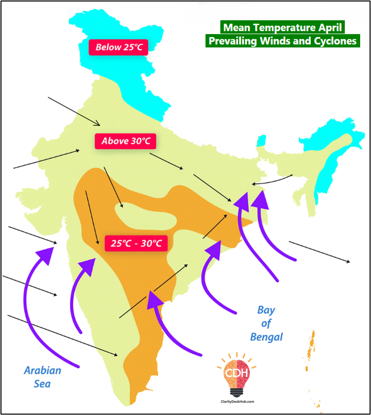
🌡️ Temperature Patterns (March to June)
| Month | Region with Highest Temp | Temp Range |
|---|---|---|
| March | Southern India | 40–45°C |
| April | Northern MP | ~45°C |
| May | Rajasthan (extreme heat) | Up to 48°C |
| June | Punjab, Haryana | Up to 50°C |
- All-time highs:
- Alwar: 50.5°C (10 May 1956)
- Ganganagar: 50.6°C (14 June 1935)
- West coast remains cooler due to moderating effect of Arabian Sea and westerlies.
- High diurnal range (~18°C) in interior regions.
- Heatwaves are common—especially in north, northwest, and eastern coastal belt.
🌡️ Heat Waves
- >6–7°C above normal = moderate; ≥8°C above = severe.
- Peak in May, common in Rajasthan, Punjab, Haryana, and spread to UP, Bihar, Odisha, Andhra.
- Northwesterlies delay sea breeze on east coast → heatwaves in Odisha/AP.
🧭 Pressure and Wind Patterns
- Low pressure forms over north and central India due to intense heating.
- However, dynamically induced divergence in NW India prevents monsoon onset.
- Winds are light and variable in early summer, then become gusty with rising convection.
💨 Local Winds and Storms
🔴 Loo
- Hot, dry winds from Iran-Balochistan-Thar region.
- Blow in May–June in NW India with avg. speed of 30–40 km/h.
- Very dehydrating and dangerous, especially in UP, Delhi, Rajasthan.
⚠️ Andhis (Dust Storms)
- Blinding dust-laden squalls, common in:
- Rajasthan, Punjab, Haryana, Delhi, UP, Bihar
- Wind speed: 50–60 km/h, visibility drops drastically.
- Followed by brief rain/squall → temperature drop.
⚡ Thunderstorms: Regional Variants
🌀 Frontal Thunderstorms
- Due to instability + upper air divergence (via jet streams)
- Form over Chota Nagpur Plateau, carried east by westerlies.
- Affect: Jharkhand, Odisha, West Bengal, Assam, NE states.
🌪️ Norwesters / Kalbaisakhis
- Violent thunderstorms in:
- Bengal, Odisha, Assam, Jharkhand
- Blow from NW direction → hence “Nor’wester”
- Very strong squalls: 60–80 km/h
- Hailstorms common (golf-ball size)
- Locally named:
- Kalbaisakhi – Bengal
- Barodoli Chheerha – Assam
- Tea Showers – NE India (beneficial for tea, jute)
🌧️ Mango Showers / Blossom Showers
- Evening convectional rain in:
- Kerala, Karnataka, Tamil Nadu
- Boost mango and coffee crops
- Called Cherry Blossoms in Karnataka
🌊 Western Disturbances (WDs) in Summer
- Frequency decreases from March to May:
- ~4 in March → ~2 in May
- Still cause snowfall in upper Himalayas
🌀 Tropical Cyclones
- Mainly in May, some in April (rare in March)
- Originate in Bay of Bengal (75%) and Arabian Sea (25%)
🔄 Movement:
| Origin | Early Direction | Later Direction | Landfall Likely |
| Bay of Bengal (May) | West/NW | Recurs NE | Bangladesh, Myanmar |
| Arabian Sea (May) | NW | Some curve NE | Some hit west coast |
- Southern origin (<10°N) in April, northern (>10°N) in May
- Severe cyclones cause devastation along Bangladesh & Arakan coast
- India gets occasional hits, mostly indirect effects (rain, wind)
🌧️ Precipitation in Summer
- Summer is not rainless, but contributes only ~1% of annual rainfall
| Region | Source | Rain Type |
| NE India | Norwesters | Sudden, heavy squalls |
| Bengal/Odisha | Norwesters + frontal | Thunderstorms |
| Kerala, Karnataka, TN | Convection | Mango/Blossom showers |
| Kashmir | WDs | Snowfall |
| NW India | Dust storms | Light rain |
Rainy Season: South-West Monsoon Season
Friends, the South-West Monsoon Season, also known as hot-wet season runs roughly from June to mid-September.
- Why “South-West”? Because the winds blow from the southwest direction — from the Arabian Sea and Bay of Bengal towards the Indian mainland.
- Why “Hot-Wet”? Because the land is already heated due to summer (hot), and now moisture-laden winds bring heavy rainfall (wet).
This is the season that literally decides the fate of Indian agriculture — the success or failure of the monsoon determines food production, water availability, and even GDP growth!
🌡️ Temperature Conditions during the South-West Monsoon Season
Now, imagine: in May, India is burning under Loo winds and 45°C heat. Suddenly, in June, dark clouds arrive with thunder and lightning — and temperatures fall by 3°C to 6°C. This sudden drop marks the onset of monsoon.
Let’s look at the pattern:
- Temperature variation: Unlike winter or post-monsoon months, temperature keeps fluctuating during this season because of breaks in rainfall and varying cloud cover.
- Rising temperature in September: As the monsoon starts retreating, clouds reduce and temperature again increases.
- Breaks in monsoon: Whenever there’s a pause in rainfall, the temperature shoots up again.
- Small diurnal range: Since clouds block the Sun during the day and trap heat at night, the difference between day and night temperature becomes small.
Now regionally:
- West of Aravalli (e.g. Rajasthan) → very high temperatures (38–40°C) due to lack of clouds and hot continental air.
- Northwest India → still above 30°C.
- Western Ghats → much cooler due to heavy rainfall.
- Tamil Nadu coast and adjoining Andhra Pradesh → above 30°C because they receive little rain from the southwest monsoon.
🌬️ Pressure and Winds during South-West Monsoon Season
Let’s recall the mechanism.
In summer, due to intense heating, a low-pressure area develops over northwest India (especially around the Thar Desert).
Meanwhile, relatively high pressure exists over the southern Indian Ocean.
👉 This creates a pressure gradient from south (high) to north (low).
So, winds start blowing from the southwest — that is, from the Arabian Sea and Bay of Bengal — towards the Indian subcontinent.
- The ITCZ (Inter-Tropical Convergence Zone), also called the Monsoon Trough, lies roughly along the Ganga plains but keeps shifting north and south depending on local weather.
- As we move southward, pressure steadily increases.
- Over the peninsular region, this gradient makes the winds flow southwest to northeast.
- When these winds reach the Indo-Gangetic Plain, they turn east to west due to land configuration and Coriolis effect.
So, remember: this entire wind system is what we call the South-West Monsoon.
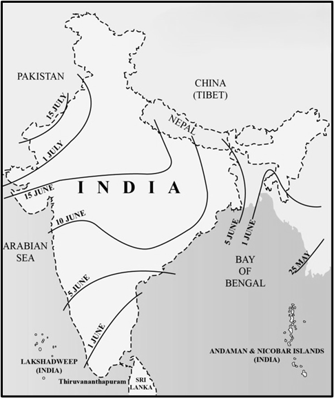
☔ Rainfall during South-West Monsoon Season
This is the main rainy season — about three-fourths (75%) of India’s annual rainfall happens now.
Key Facts:
- Average rainfall over Indian plains: ~87% of total annual rainfall.
- Normal onset:
- 20th May – Andaman & Nicobar Islands
- 1st June – Kerala coast (official onset for mainland India)
👉 The monsoon moves faster through the Bay of Bengal than through the Arabian Sea.
It advances rapidly northwards, bringing thunder, lightning, and downpours — this sudden burst of rain is called the Monsoon Burst.
The onset can vary slightly — usually between 29 May and 7 June.
🌦️ Break in the South-West Monsoons
Now, very important — UPSC loves this term “break in monsoon”.
At times, monsoon rains suddenly pause for a few days — that’s called a break.
Reason: The Monsoon Trough (ITCZ) shifts northwards towards the foothills of the Himalayas.
As a result:
- Rainfall decreases sharply over most of India.
- But rainfall increases in:
- Sub-Himalayan regions
- Southern slopes of the Himalayas
- Parts of Northeast India
- Southeast Peninsula
👉 Usually, one or two breaks occur every season.
Chances of at least one break = 85 out of 100 years, and they mostly occur around the second week of August.
🌪️ Depressions during the South-West Monsoon Season
Another key feature — Depressions.
These are intense low-pressure systems, crucial for rainfall distribution.
They form over the Bay of Bengal, Arabian Sea, and sometimes even over land.
Facts to remember:
- Around 3–4 depressions per month form from June to September.
- They usually move north-westward and cause widespread rainfall in their path.
- Moisture source: They’re “sucked inward” by river deltas (Ganga, Mahanadi, Godavari, Krishna, Cauvery).
- Most originate to the west of 90°E longitude in the Bay of Bengal.
- In the Arabian Sea (June–July), depressions may affect Gujarat or Maharashtra.
- Central and northern India get most of their monsoon rainfall due to these depressions.
- By August–September, formation of depressions becomes rare, and those that do form are near Maharashtra–Gujarat coast.
- If depressions are absent or deviate from their normal path → rainfall deficit occurs.
🌈 Chief Characteristics of South-West Monsoon Rainfall
Finally, let’s summarise the main characteristics — these are often asked directly in Mains or Prelims:
- Duration: Most rainfall occurs between June–September.
- Nature: Rainfall is orographic — caused by uplift of moist air over mountains (e.g. Western Ghats, Khasi Hills).
- Distance from sea: Rainfall decreases inland — coastal regions get more, interiors less.
- Breaks: Rainless intervals during the season are called breaks.
- Spatial variation: Distribution is highly uneven — Cherrapunji gets >1100 cm, while western Rajasthan gets <10 cm!
- Uncertainty: Monsoon may arrive early, late, withdraw early, or even fail — leading to agricultural and economic impacts

South-West Monsoon – Two Branches
Once the south-west monsoon winds strike the Kerala coast around 1 June, they don’t move northward as one single current.
Instead, they split into two major branches:
- The Arabian Sea Branch
- The Bay of Bengal Branch
Think of it like two powerful arms of the same system embracing the Indian subcontinent — one from the west, the other from the east.
Arabian Sea Branch
This branch moves northward along the west coast of India.
- By 10 June, it reaches Mumbai.
- It continues to advance northward and inland, bringing rain to large parts of India.
💪 Why is this branch more powerful?
- Arabian Sea is larger than the Bay of Bengal → more moisture source.
- Entire Arabian Sea current hits India’s western coast directly, whereas only a part of the Bay of Bengal current enters India (the rest goes to Myanmar, Thailand, Malaysia).
Hence, the Arabian Sea branch carries more moisture and energy.
☔ Streams of the Arabian Sea Branch
When this branch strikes the Indian mainland, it splits into three smaller streams:
Stream 1 – Western Ghats Stream
- Strikes perpendicularly against the Western Ghats → Orographic rainfall (caused when moist air rises over mountains).
- Windward side (Kerala, Karnataka, Goa, Konkan) → 400–500 cm rainfall.
- Leeward side (Maharashtra interior, Karnataka plateau) → drastically less, around 30–50 cm.
- Beyond the dry belt, as air rises again over the Deccan plateau, rainfall slightly increases.
🟢 Concept link: This creates one of India’s sharpest rainfall contrasts over a few kilometres — from lush greenery to semi-arid plateau.
Stream 2 – Narmada–Tapti Rift Valley Stream
- Moves inland through the Narmada–Tapti trough (a rift valley).
- Because there are no major hills across this path, rainfall is moderate.
- Some interior cities like Nagpur get rainfall from this stream.
Stream 3 – Aravalli Parallel Stream
- Moves parallel to the Aravalli Range, so no orographic lift occurs.
- Hence, very little rainfall in Rajasthan, creating the Thar Desert.
- Only slight uplift on south-eastern Aravalli slopes gives Mount Abu around 170 cm, while nearby plains get only 60–80 cm.
🌊 Bay of Bengal Branch
This branch advances much faster because the Bay of Bengal arm directly faces the monsoon trough and has a longer fetch of warm water.
- By 7 June, it reaches Kolkata.
- It first strikes Assam and Meghalaya, and then, after hitting the Himalayan foothills, it gets deflected westward.
- Moving along the Ganga plains, it gradually loses moisture.
☔ Streams of the Bay of Bengal Branch
Stream 1 – Meghalaya Stream
- Crosses the Ganga–Brahmaputra delta, then hits the southern slopes of Khasi Hills in Meghalaya.
- Result: World’s heaviest rainfall.
- Cherrapunji: ~1102 cm annually.
- Mawsynram: ~1221 cm, currently the wettest place on Earth.
- Why so much rain?
- Moist air from the south gets trapped in a funnel-shaped valley, forced abruptly upward — a textbook example of orographic uplift.
Stream 2 – Ganga Plains Stream
- Deflected westward along the Himalayan foothills.
- Produces widespread rainfall over Bihar, UP, Haryana, and Punjab.
- But rainfall declines steadily from east to west, as the winds lose moisture.
- Example: Kolkata ~160 cm → Delhi ~60 cm.
☀️ Why is Tamil Nadu Dry during the South-West Monsoon?
Despite being near the coast, Tamil Nadu receives little rainfall now because:
- It lies in the rain shadow of the Western Ghats (the Arabian Sea branch loses moisture before crossing).
- The Bay of Bengal branch runs parallel to its coast, not striking it perpendicularly.
Hence, TN waits for the Northeast Monsoon (Oct–Dec) for its main rains.
NORTH-EAST MONSOON (Retreating Monsoon)
Now comes the return journey of the monsoon winds.
After mid-September, the southwest monsoon starts withdrawing gradually — not abruptly like its onset.
🗓️ Withdrawal pattern:
- September: From north-west India (Punjab, Rajasthan).
- October: From central and peninsular India.
- December: Finally withdraws from the Coromandel Coast (Tamil Nadu).
So, while Punjab gets the monsoon in July and loses it by mid-September, the Coromandel coast receives rainfall till December — exactly opposite in timing!
🌡️ Temperature Changes
- As clouds disappear, skies clear and temperatures fall rapidly.
- Day-night difference (diurnal range) increases because there are no clouds to trap heat at night.
💨 Pressure and Winds
- The monsoon trough weakens and shifts southwards.
- The winds reverse — now blowing from northeast to southwest.
- This is why the period is called the North-East Monsoon Season.
However, the onset isn’t as distinct as that of the southwest monsoon; it happens gradually.
🌪️ Cyclones during Retreating Monsoon
This is the cyclone season of India, especially in the Bay of Bengal.
Key points:
- Bay of Bengal sees more cyclones than the Arabian Sea.
- Peak months: October and early November.
- Origin zone: 8° N – 14° N latitudes.
- Initially move west/north-west, then recurve northeast.
- Most vulnerable coasts: Tamil Nadu, Andhra Pradesh, Odisha, West Bengal.
Sometimes, cyclones cross the peninsula and re-emerge in the Arabian Sea, often regaining strength.
👉 Arabian Sea cyclones (12°–17° N in Oct, 8°–13° N in Nov) usually move away from the coast, though ~25 % recurve toward Maharashtra–Gujarat.
🌨️ Western Disturbances
Meanwhile, north-west India experiences cloudy weather and light rain/snow due to western disturbances from the Mediterranean region — especially over J&K, Himachal, and Uttarakhand.
🌦️ Precipitation Pattern during Retreating Monsoon
- Most of India is dry — low humidity and clear skies.
- But Tamil Nadu, south Andhra, and parts of Kerala get their main rainfall now.
- Reason: The retreating monsoon winds pick up moisture from the Bay of Bengal and pour it on the Coromandel Coast.
Hence, this is called the “Reverse Monsoon” or “Northeast Monsoon Rainfall”.
- Reason: The retreating monsoon winds pick up moisture from the Bay of Bengal and pour it on the Coromandel Coast.
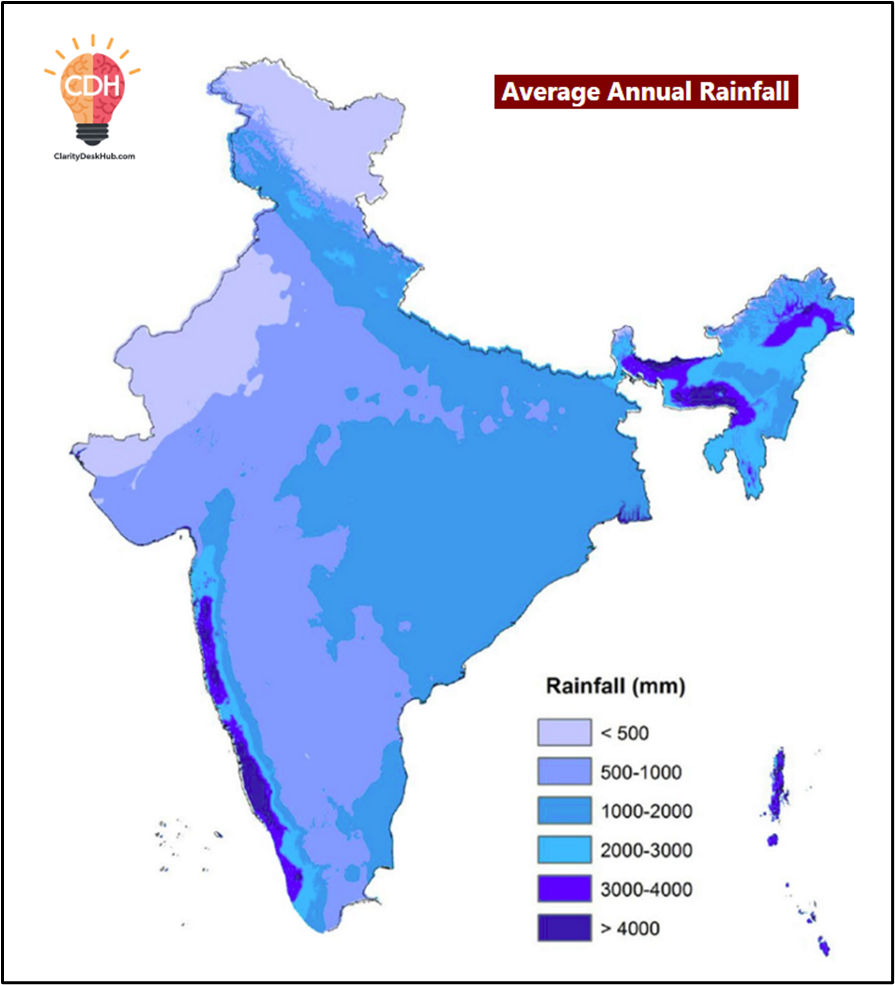
🌧️ ANNUAL RAINFALL DISTRIBUTION (South-West + Retreating Monsoon)
Let’s visualise India in terms of Isohyets — lines joining places of equal rainfall.
| Rainfall Zone | Region & Amount | Characteristics |
|---|---|---|
| Very High (≥ 200 cm) | Western slopes of Western Ghats (Thiruvananthapuram → Mumbai); Northeast states (Assam, Meghalaya, Mizoram, Nagaland, Arunachal Pradesh) | Orographic rainfall; perennial rivers |
| High (100–200 cm) | Northern plains, Odisha, east slopes of Western Ghats, MP, Andhra, TN | Major agricultural belt |
| Low (50–100 cm) | East Rajasthan, Punjab, Haryana, west UP, Gujarat, Maharashtra interior, rain-shadow areas of AP, Karnataka, Telangana | Semi-arid zone |
| Very Low (< 50 cm) | Western Rajasthan, Kachchh, Ladakh | Desert & cold-desert climates |
Wettest place: Mawsynram (1221 cm).
Driest region: Western Rajasthan & Ladakh (< 10–20 cm).