
Natural Vegetation of India
🌱 What is Natural Vegetation?
Imagine a piece of land where plants grow on their own — without any human interference, where nature decides what grows, where, and how. This self-grown plant life is called Natural Vegetation.
Now, India is a vast country with mountains, deserts, plains, plateaus, and coasts. Naturally, the vegetation here also varies significantly across regions. But the question is: What decides this variation? Why do thick forests grow in one area and dry scrubs in another?
🧭 Three Major Determinants of Natural Vegetation
Just like the recipe of a dish depends on ingredients, the ‘type’ of natural vegetation depends on three key factors:
- Climate – especially rainfall and temperature
- Soil – the base in which plants grow
- Topography – the physical layout of the land
Let’s understand each one:
🌧️ Climate: Rainfall and Temperature – The Prime Movers
These are the most important factors. Climate is like the director of a play — it decides the overall script.
✅ Rainfall: The Deciding Factor of Density
The amount of annual rainfall a region receives directly affects the type of vegetation that can grow there. Think of rainfall as the water supply to plants. More water, denser the greenery.
Let’s understand:
| Annual Rainfall | Type of Vegetation | Real-world example |
|---|---|---|
| 200 cm or more | Tropical Evergreen Rain Forests | Western Ghats, North-East India |
| 100 to 200 cm | Monsoon Deciduous Forests | Central India, lower Himalayas |
| 50 to 100 cm | Drier Deciduous / Savanna | Parts of Rajasthan, MP |
| 25 to 50 cm | Dry Thorny Scrub (Semi-arid) | Western Rajasthan, Gujarat |
| Below 25 cm | Desert Vegetation (Arid) | Thar Desert |
🧠 Analogy: Think of rainfall as the amount of “funding” plants receive. Rich rainfall is like a good budget — more lush, complex vegetation can “afford” to grow. Lesser rainfall? You get more minimal, survivalist vegetation.
🌡️ Temperature: The Deciding Factor in Hilly Regions
While rainfall is the hero in plains, temperature becomes the key in mountainous regions, especially the Himalayas and areas above 900 metres elevation.
As you go up a mountain, the temperature drops. This change in temperature modifies the type of vegetation in clear zones:
- Base level (Tropical) – Sal, teak, and dense trees
- Mid-altitudes (Sub-tropical/Temperate) – Oaks, pines
- High altitudes (Alpine) – Short shrubs, mosses
- Snowline and above – Practically no vegetation
🧠 Analogy: Climbing a mountain is like moving from the equator to the poles — the temperature decreases, and so does the type of vegetation 😊.
🧱 Soil – The Nutrient Bed
In some areas, it’s not rainfall or temperature, but the soil itself that decides what grows.
Examples:
- Mangrove forests grow in saline, marshy soil — like in the Sundarbans.
- Swamp forests exist in areas with waterlogged soils.
🧠 Think of soil as the “diet plan” for plants. Just like certain diets suit certain people, certain soils support specific plant types.
🏔️ Topography – The Layout of the Land
This refers to the physical features — hills, valleys, slopes, coastlines.
For example:
- Alpine vegetation grows only in high-altitude areas like the Himalayas.
- Tidal forests (like mangroves) grow along coastal areas and river deltas.
So, topography might not always decide vegetation, but it shapes it — like the stage on which the play is performed.
🌿 Classification of Natural Vegetation of India
📌 What is the Basis of Classification?
To classify anything in geography, we ask: “What factors determine the variety?”
In this case, the natural vegetation of India is primarily classified on the basis of:
- Rainfall – Most decisive factor
- Temperature – Especially in hilly regions
- Soil – Determines specific types like mangroves
- Topography – Influences Mountain and coastal vegetation
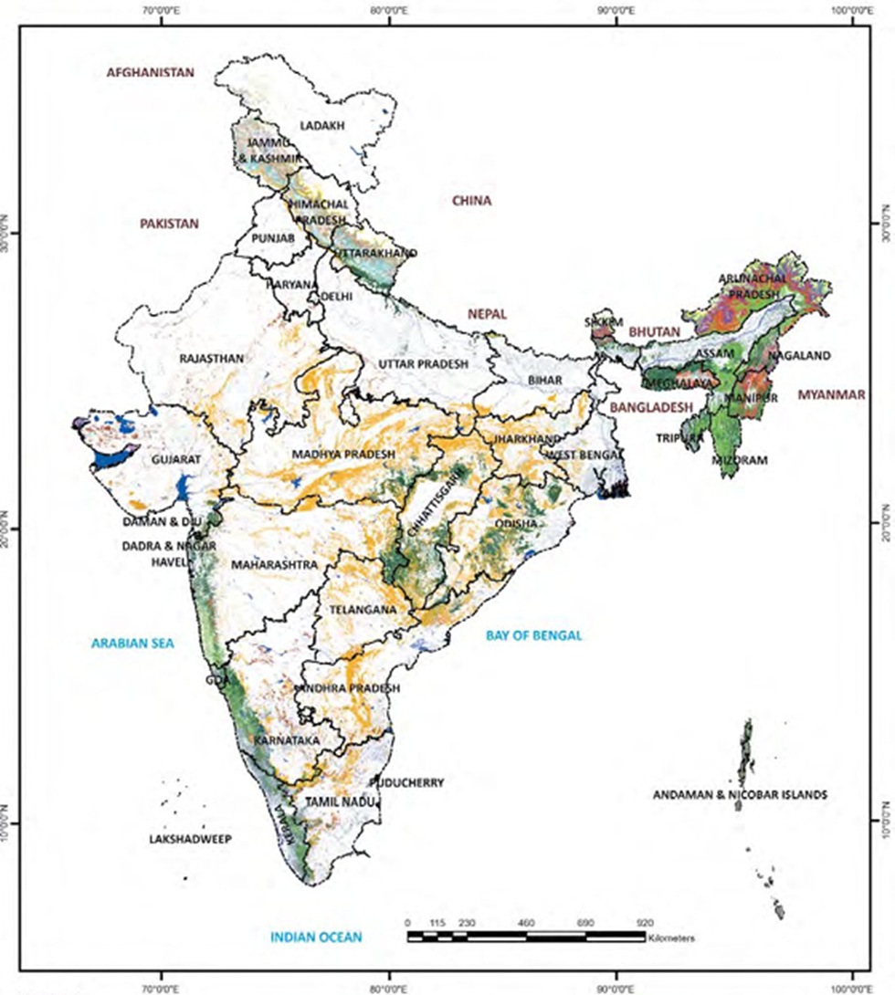
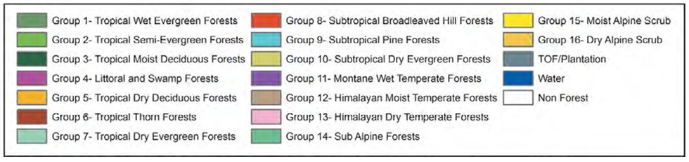
But the most accepted scientific classification is by Champion and Seth (1968). They categorized Indian forests into:
5 Major Types and 16 Sub-types
This classification helps us understand how vegetation changes horizontally (from region to region) and vertically (with altitude).
A. Moist Tropical Forests
- Tropical Wet Evergreen
- Tropical Semi-Evergreen
- Tropical Moist Deciduous
- Littoral and Swamp
B. Dry Tropical Forest
- Tropical Dry Evergreen
- Tropical Dry Deciduous
- Tropical Thorn
C. Montane Sub-Tropical Forests
- Sub-tropical broad leaved hill
- Sub-tropical moist hill (pine)
- Sub-tropical dry evergreen
D. Montane Temperate Forests
- Montane Wet Temperate
- Himalayan Moist Temperate
- Himalayan Dry Temperate
E. Alpine Forests
- Sub-Alpine
- Moist Alpine scrub
- Dry Alpine scrub
As per ISFR 2019, % of Area under Different Forest Type group:
| Forest Type in India | % of Total Area |
|---|---|
| Tropical Dry Deciduous | 40.86 |
| Tropical Moist Deciduous | 17.65 |
| Tropical Semi-Evergreen | 9.27 |
| Plantation/TOF | 8.45 |
| Sub-Tropical Broad Leaved Hill | 4.26 |
| Rest below 4 % | |
🔎 Insight: Deciduous forests (moist + dry) together make up more than 65% of India’s forests. They are the most dominant due to our monsoonal climate.
Conclusion:
The easiest way to understand this classification is to think like this:
In India, forests change according to the climate of the region.
- Heavy rainfall? You’ll get evergreen forests.
- Moderate rainfall? You see deciduous forests.
- Very little rainfall? That’s where thorn forests grow.
- And on mountains? Vegetation changes with altitude—from sub-tropical to alpine zones.
This is exactly what Champion and Seth’s classification captures.
It’s like a natural ‘forest ladder’, where each step represents a different type of forest, based on environmental conditions. We will explore these classifications in next sections in detail