
Agroclimatic Zones
Let’s begin with a basic truth:
Agriculture is not just a human activity—it is a deeply natural one.
It depends heavily on land and water, which are not uniformly available across regions. Therefore, if we are serious about agricultural development, we cannot apply a one-size-fits-all model. Instead, we must plan based on nature’s template—the physical environment of each region.
Hence, in 1989, the Planning Commission, with help from NRSA (National Remote Sensing Agency), created 15 Agro-Climatic Zones.
🗺️ What Are Agroclimatic Zones (ACZs)?
An Agro-Climatic Zone is a land unit carved out based on climatic conditions, soil type, water resources, and the suitability of crops, to ensure efficient and location-specific agricultural planning.
🧩 Key Physical Factors That Define ACZs
- Climate: Temperature and humidity affect the type of crops that can be grown.
- Rainfall: Determines water availability—whether irrigation is needed or not.
- Soil Characteristics (Edaphic factors): Different crops require different soil types.
- Water Resources: Both surface water and groundwater availability.
- Physiography (Landform & terrain): Most fundamental control in India’s case.
🔍 Note: Although we often blame monsoon for agricultural failures, in India’s context, physiographic factors (like mountains, plateaus, plains) play an even deeper role—they decide how climate and water behave in each region.
🏔️ How Do India’s Physiographic Features Influence Agriculture?
Let’s take an example:
- The Himalayas prevent cold winds from Central Asia, maintaining a warm latitudinal regime in most of India.
- The Western Ghats and their orientation decide where the monsoon rain falls—leading to wet Western coasts and dry interior plateaus.
- Soil and underground water are influenced by the geology—the type of rocks and terrain (parent rock, slope, etc.).
Thus, the ultimate agricultural potential of a region is tied to its physiography.
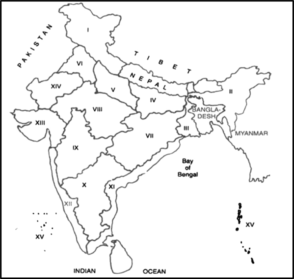
🗺️ Agro-Climatic Zones of India (Planning Commission, 1989)
| Zone | States/Location | Topography & Soil | Climate | Major Crops | Major Issues | Suggestions |
|---|---|---|---|---|---|---|
| I. Western Himalayan Region | J&K, Himachal Pradesh, Uttarakhand (hills) | Snow-covered peaks, river valleys, thin soils | Summer: 5–30°C, Winter: 0 to -4°C; Cold climate | Rice (valleys), maize (hills), wheat, barley, oats, peas, apples, saffron | Accessibility, erosion, landslides, outdated farming | HYV seeds, orchard-based farming, storage & marketing |
| II. Eastern Himalayan Region | NE States, Sikkim, Darjeeling, Assam Hills | Rugged hilly terrain | 25–30°C (Jul), 10–20°C (Jan); Rainfall: 200–400 cm | Rice, maize, potato, tea, oranges, pineapples | Shifting cultivation, low soil fertility | Terrace farming, rural infrastructure |
| III. Lower Gangetic Plains | West Bengal, East Bihar | Low-lying alluvial plains, high water table | 26–41°C (Jul), 9–24°C (Jan); Rainfall: 100–200 cm | Rice (Aman, Aus, Boro), jute, maize, potato, pulses | Monocropping, low diversification | Diversify with fishery, banana, poultry, seed banks |
| IV. Middle Gangetic Plains | East UP, North Bihar | Fertile Ganga plain | Similar to Lower Gangetic | Rice, maize, millets (Kharif); wheat, pulses, barley (Rabi) | Wastelands, low diversification | Agro-forestry, pisciculture, reclaim fallow lands |
| V. Upper Gangetic Plains | Central & West UP, Haridwar, Udham Singh Nagar (Uttarakhand) | Fertile, alluvial plains | Rainfall: 75–150 cm; Sub-humid | Rice, wheat, sugarcane, oilseeds, cotton | Groundwater stress | Mixed cropping, dairy, horticulture, mechanization |
| VI. Trans-Gangetic Plains | Punjab, Haryana, Delhi, NW Rajasthan | Fertile alluvial plains | Semi-arid; Rainfall: 65–125 cm | Wheat, rice, sugarcane, cotton | Water logging, salinity, falling water table | Pulses, vegetables, horticulture, livestock |
| VII. Eastern Plateau & Hills | Jharkhand, Odisha, Chhattisgarh | Undulating land, red-yellow soils | 26–34°C (Jul), 10–27°C (Jan); Rainfall: 80–150 cm | Rainfed rice, millets, ragi, oilseeds, potato | Rainfed farming, soil erosion | Pulse promotion, irrigation, soil conservation |
| VIII. Central Plateau & Hills | West MP, parts of UP & Rajasthan | Rocky, red & black shallow soils | Rainfall: 80–120 cm; Hot summers, mild winters | Sorghum, maize, cotton, groundnut; wheat, gram (Rabi) | Soil erosion, weak irrigation | Watershed, agro-forestry, livestock rearing |
| IX. Western Plateau & Hills | Maharashtra (non-Konkan), MP | Undulating, basaltic base, black soil | Rainfall: 75–150 cm (monsoon-based) | Cotton, soybean, tur, wheat (Rabi), groundnut | Drought-prone, water scarcity | Dryland farming, watershed, check-dams |
| X. Southern Plateau & Hills | Karnataka, Telangana, TN | Rolling terrain, red loamy/lateritic soil | Rainfall: 70–130 cm; Bimodal pattern (SW & NE) | Ragi, millets, pulses, oilseeds, cotton | Erratic rains, rainfed dependency | Rainwater harvesting, horticulture, sericulture |
| XI. East Coast Plains & Hills | Coastal AP, TN, Odisha | Deltaic plains (Godavari, Krishna), alluvial soil | Rainfall: 90–200 cm; Cyclone-prone | Rice, coconut, banana, groundnut, sugarcane | Floods, salinity, cyclones | Resilient farming, aquaculture, processing units |
| XII. West Coast Plains & Ghats | Kerala, Konkan, Coastal Karnataka, Goa | Narrow plains, Western Ghats; Laterite soil | Rainfall: 200–400 cm; Humid climate | Rice, coconut, spices, arecanut, rubber | Soil erosion, land fragmentation | Plantation, eco-tourism, organic farming |
| XIII. Gujarat Plains & Hills | Saurashtra, Kutch, mainland Gujarat | Alluvial (mainland), saline (Kutch), black soil | Rainfall: 40–120 cm; Arid to semi-arid | Cotton, groundnut, wheat, bajra | Drought, salinity, water scarcity | Salt-tolerant crops, drip irrigation |
| XIV. Western Dry Region | Western Rajasthan (Thar) | Sandy desert, low-fertile soils | Rainfall: <25 cm; Extreme temperature | Bajra, moong, moth, guar, arid fruits | Water stress, desertification | Drip irrigation, arid crops, camel/goat farming |
| XV. Island Region | Andaman, Nicobar, Lakshadweep | Coral (Lakshadweep), volcanic (Andaman), loamy/sandy soils | Rainfall: 200–300 cm; Hot & humid | Coconut, arecanut, fruits, limited rice | Isolation, cyclones, poor access | Coconut industry, fisheries, marine aquaculture |
🌍 Why Does This Regionalisation Matter?
Just like tailor stitches clothes according to a person’s body type, agricultural planning must suit the physical profile of each region.
Thus, India’s agricultural regionalisation almost overlaps with its physiographic regionalisation. This alignment ensures that:
- We grow the right crops in the right places.
- We use water wisely and sustainably.
- We protect the ecology of fragile zones.
🌾 Principles of Agroclimatic Regional Planning
The concept promotes sustainable, inclusive, and ecological agriculture through:
- Local area-based planning
- Minimal ecological disruption
- People’s participation (like PRIs – Panchayati Raj Institutions)
- Balanced development: Not just crop production but livestock, fisheries, forestry—whatever suits the zone.
🧠 Final Thought: A Progressive Vision
Agroclimatic zoning is not just an administrative division—it’s a scientific and ethical approach to agriculture. It respects:
- The limits of nature
- The potential of people
- And the need for sustainability
It is a progressive framework that ensures agriculture is not just about more yield, but also about healthy ecosystems and empowered communities.