
The k-Principle in Central Place Theory
Once you’ve understood that Central Place Theory (CPT) is about the distribution and hierarchy of settlements, the next question arises:
How exactly are these settlements arranged in space?
This is where Christaller’s K-Principle comes into play. Think of this as the mathematical blueprint behind the hexagonal pattern we saw earlier.
🧩 What is the “K” in K-Principle?
In CPT, ‘K’ represents a value that explains the relationship between a higher-order central place and the lower-order centers surrounding it.
It answers this question:
How many lower-order centers fall under the influence of a higher-order center, and how are their market areas organized?
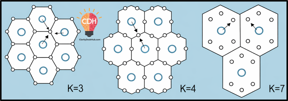
Christaller suggested three possible spatial arrangements based on different functional priorities:
| Principle | K-Value | Focus Area |
|---|---|---|
| Marketing | K = 3 | Market efficiency |
| Transportation | K = 4 | Transport efficiency |
| Administrative | K = 7 | Governance/admin |
Let’s understand each of them one by one.
1️⃣ Marketing Principle (K = 3)
🎯 Focus: Maximizing market efficiency
This is Christaller’s original and most emphasized idea. He believed that settlements develop primarily based on economic or market logic—where sellers try to reach maximum consumers with minimum duplication.
🔄 How does it work?
- A higher-order center (say, a town) will serve one-third of the market area of each of the six surrounding lower-order centers (like villages).
- So, the total influence area becomes:
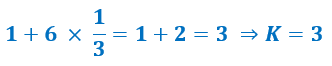
Each central place has six neighbors, and its influence extends into one-third of each—thus optimizing market coverage without overlapping.
🧠 Conceptual Visual:
- Imagine a hexagon with a higher-order town in the center.
- Around it, six smaller towns or villages are placed at equal distances.
- This layout ensures no area is left unserved and no over-serving occurs.
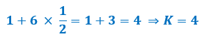
2️⃣ Transportation Principle (K = 4)
🎯 Focus: Transport connectivity and route optimization
Now imagine a world where the goal is not just to reach people, but to connect places efficiently via transport routes—like railways, highways, or major roads.
🔄 How does it work?
- Central places (both high-order and low-order) align themselves along major transport routes (straight lines).
- A lower-order center is placed exactly halfway between two higher-order centers—forming a linear chain.
- Now, each higher-order place includes half of the service area of six neighbouring lower-order centers:
🛤 Real-World Analogy:
- Picture towns forming along a railway line.
- Between every two major stations (higher-order), there’s a smaller stop (lower-order).
- The focus here is equal spacing along transport corridors, which reduces travel cost and time.
3️⃣ Administrative Principle (K = 7)
🎯 Focus: Governance and administrative efficiency
This model is based on political and administrative logic, where the goal is clear jurisdiction and no split governance.
🔄 How does it work?
- A higher-order center completely controls six surrounding lower-order centers.
- There is no division of any complementary region—each belongs wholly to one administrative center.
- Therefore:

🏛 Implication:
- In this case, the boundary of administrative control is sharp and unshared.
- Each lower-order place reports entirely to one higher-order center.
- This model is ideal for planning districts, talukas, police jurisdictions, etc.
🔍 Summary Table for Quick Revision
| Principle | K-Value | Core Logic | Area Served by High-Order Center |
|---|---|---|---|
| Marketing | K = 3 | Market efficiency, non-overlapping | Serves 1 + 2 = 3 areas |
| Transport | K = 4 | Route-based development | Serves 1 + 3 = 4 areas |
| Administrative | K = 7 | Unshared control, governance focus | Serves 1 + 6 = 7 complete areas |
📝 Conclusion
Christaller didn’t just say “cities form in hexagons.” He said that the way cities form depends on what you’re optimizing for:
- 📈 Markets? → K = 3
- 🚛 Transport? → K = 4
- 🏛 Administration? → K = 7
Limitations of Central Place Theory (CPT)
While Christaller’s Central Place Theory is a landmark in settlement geography, it is still a model—and all models, by nature, simplify reality.
Let’s now examine its limitations, both conceptually and practically.
1️⃣ Perfect Isotropic Surface is Rarely Found
🧭 Christaller assumed that the earth’s surface is isotropic—meaning:
- Completely flat
- Uniform soil quality
- No rivers, mountains, forests, or barriers
- Equal accessibility in all directions
🔍 Reality Check:
- In the real world, geography is highly heterogeneous.
- There are natural barriers and variations in terrain that disrupt uniform development.
- For example, cities may cluster along coasts, rivers, or highways, not in neat hexagons.
📌 So, the foundational assumption itself is idealistic and rarely matches field conditions.
2️⃣ Hexagonal Settlement Patterns are Rare
🔷 Christaller’s model visualized settlements in hexagonal patterns to avoid gaps and overlaps.
🔍 Reality Check:
- Settlements grow in irregular shapes based on multiple factors—like:
- Historical development
- Natural resource locations
- Political boundaries
- Rarely do we find symmetrical, hexagonal spatial patterns on the ground.
📌 Thus, the neatness of CPT is more mathematical than geographical.
3️⃣ Humans Are Not Always Rational
👥 Christaller assumed:
- Buyers and sellers are rational
- People always travel to nearest central place
- Choices are made based on economic logic only
🔍 Reality Check:
- Human decisions are shaped by:
- Brand loyalty
- Cultural preferences
- Emotional attachments
- Social networks
- For instance, a person may bypass a nearby town to shop in a religiously significant or historically popular center farther away.
📌 This exposes the flaw of assuming that all economic behavior is “rational.”
4️⃣ One Size Fits All Approach
📏 CPT assumes uniform distribution of → Population, Resources, Purchasing power
🔍 Reality Check:
- Settlements grow differently based on:
- Colonial history
- Resource endowments
- Urban policy
- Industrial corridors
- The needs and behaviors of people in rural Bihar differ greatly from those in urban Maharashtra.
📌 So, CPT’s uniform logic does not adapt well to diverse socio-economic realities.
🧠 Final Perspective
Even though the theory is idealistic, it gained immense academic value because:
✔️ It was the first structured attempt to explain settlement hierarchy.
✔️ It provided a quantitative and spatial model to analyze urban growth.
✔️ Many modern spatial models (like Lösch’s theory and urban planning algorithms) were built on Christaller’s foundation.
🧾 “Christaller gave us a compass to navigate the maze of urban geography—even if the map wasn’t perfect.”