Latitudes and Longitudes
Introduction to Latitudes and Longitudes
Imagine you are an explorer navigating an endless ocean. You look around—there is only water everywhere. How do you know where you are? How can you tell someone your exact location so they can find you? This is where the system of latitudes and longitudes comes in—a global address system designed to pinpoint any place on Earth with precision.
A Grid Across the Globe
Cartographers and geographers have drawn an invisible grid over Earth’s surface, much like the lines you see on graph paper. These lines help us identify locations accurately. These are called:
- Latitudes – Horizontal lines running parallel to the equator.
- Longitudes – Vertical lines running from the North Pole to the South Pole.
Finding a Location: The Coordinate System
Now, let’s put both latitudes and longitudes together. Think of them as the X and Y axes on a graph.
For example, if you want to find New Delhi, its coordinates are 28° N Latitude, 77° E Longitude.
- This means New Delhi is 28° north of the Equator and 77° east of the Prime Meridian.
- Using these coordinates, you can pinpoint the exact location of any place on Earth.
Latitudes and longitudes are the GPS of the past—before satellites, explorers and sailors used these imaginary lines to navigate. Today, your smartphone, Google Maps, and international flights all rely on this system to function.
So, the next time you check your location on your phone, remember—you’re using the same system that helped ancient mariners sail across uncharted waters and modern pilots fly across continents!
Here is a YouTube video which will clear your concept on Latitudes and Longitudes:
Latitude and Longitude | Using Coordinates to Find Places on a Map
Latitude or Parallel: The Horizontal Markings on Earth
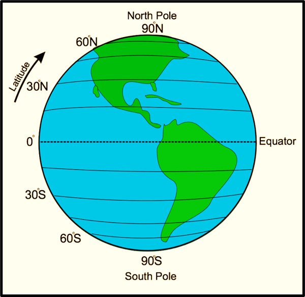
Think of Earth as a giant stack of pancakes 🍽️. Each pancake represents a parallel—a line of latitude running horizontally around the globe. These latitudes, help us measure how far north or south a place is from the equator.
What is Latitude?
- Latitude is the angular distance of a place north or south of the equator, measured in degrees from the Earth’s center.
- These lines run parallel to the equator and never meet.
- The equator is 0° latitude, while the North Pole is 90° N and the South Pole is 90° S.
Why is a Degree of Latitude Not Uniform?
You might assume that the distance between two latitude lines is always the same, but it slightly varies because Earth is not a perfect sphere—it is flattened at the poles.
- At the Equator, the distance of one degree of latitude is 110.57 km.
- At 45° latitude, it increases to 111.13 km.
- At the Poles, it is 111.7 km.
- On average, we consider it 111 km (69 miles) per degree.
This slight variation occurs because the Earth bulges at the equator and is compressed at the poles.
Important Parallels of Latitude
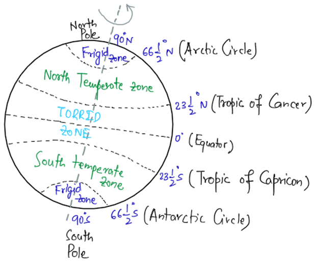
Apart from the equator (0°), North Pole (90° N), and South Pole (90° S), there are four other crucial latitudes:
- Tropic of Cancer (23½° N) – The northernmost point where the Sun is directly overhead at noon once a year (Summer Solstice, June 21).
- Tropic of Capricorn (23½° S) – The southernmost point where the Sun is directly overhead at noon once a year (Winter Solstice, December 21).
- Arctic Circle (66½° N) – Marks the region where at least one full day of continuous daylight and one full day of darkness occur each year.
- Antarctic Circle (66½° S) – The same phenomenon as the Arctic Circle but in the Southern Hemisphere.
Latitudinal Heat Zones of the Earth
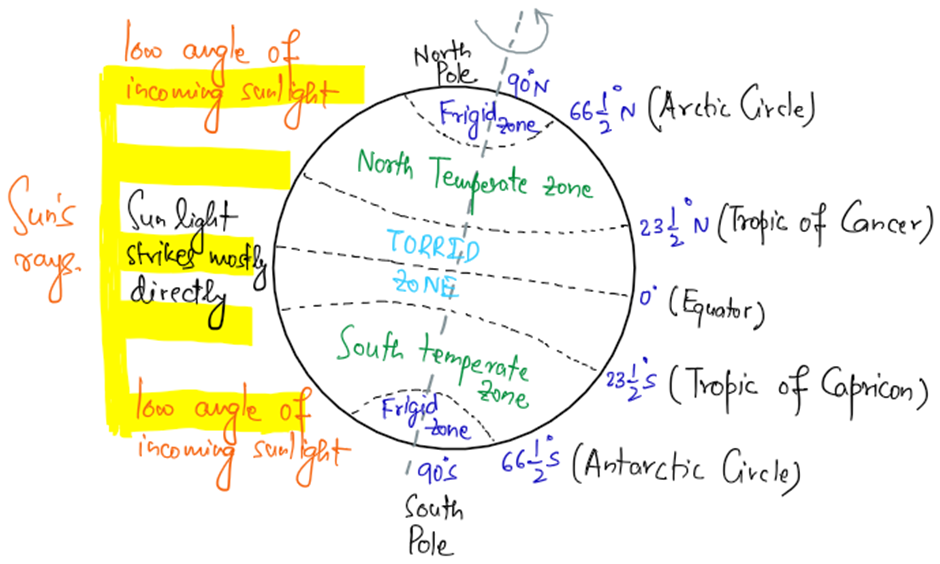
The Sun doesn’t shine equally everywhere. Depending on latitude, different regions receive different amounts of heat, creating three major heat zones.
1. Torrid Zone (The Hottest Zone)
- Lies between the Tropic of Cancer (23½° N) and the Tropic of Capricorn (23½° S).
- The midday sun is overhead at least once a year in every place within this zone.
- This area receives maximum heat due to direct sunlight.
- Example: Countries like India, Brazil, and Indonesia fall in this zone.
2. Temperate Zones (Moderate Climate)
- Located between the Tropic of Cancer and the Arctic Circle (Northern Hemisphere) and between the Tropic of Capricorn and the Antarctic Circle (Southern Hemisphere).
- The Sun never shines directly overhead in these zones, and the angle of sunlight decreases as you move away from the tropics.
- These areas experience moderate temperatures, with distinct seasons—summer, winter, autumn, and spring.
- Example: Most of Europe, the USA, and southern Australia fall in this zone.
3. Frigid Zones (The Coldest Regions)
- Found beyond the Arctic Circle (66½° N) in the Northern Hemisphere and the Antarctic Circle (66½° S) in the Southern Hemisphere.
- The Sun never rises high in the sky, and its rays are always slanting, leading to extreme cold.
- These regions experience polar nights and midnight sun, where the sun does not set for months in summer and does not rise for months in winter.
- Example: Antarctica, Greenland, and northern parts of Canada and Russia belong to this zone.
Final Thought: Why Do Latitudes Matter?
Latitudes don’t just help in locating places; they define climatic zones, seasons, and life patterns on Earth. From the blazing heat of the tropics to the frozen silence of the poles, latitudes shape our world in ways we often overlook.
Longitude or Meridian: The Vertical Mapping of Earth
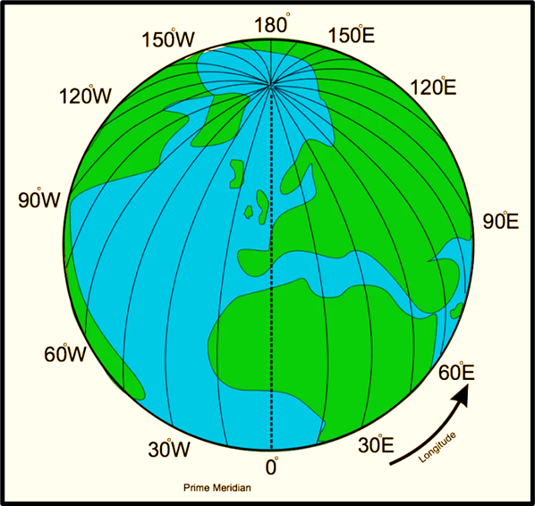
Now, imagine peeling an orange 🍊. The natural segments of the orange run from top to bottom, meeting at the stems—just like longitudes, which run vertically from pole to pole. They are also called meridians and help us measure how far east or west a place is from the Prime Meridian (0° longitude).
What is Longitude?
- Longitude is the angular distance of a place east or west of the Prime Meridian, measured in degrees from the Earth’s center.
- These lines are semi-circles that meet at the North and South Poles and cross the equator perpendicularly.
- Unlike latitudes (which are parallel), all longitudes are equal in length.
The Prime Meridian (0° Longitude)
- In 1884, geographers decided to use the meridian passing through the Royal Astronomical Observatory in Greenwich, England, as the Prime Meridian (0°).
- Longitudes east of Greenwich are labeled E (East), and those west of Greenwich are labeled W (West).
- The maximum longitude is 180°, meaning the total range is 0° to 180° E and 0° to 180° W.
Longitude and Time: Why Does It Matter?
Longitudes are not just for mapping locations; they help determine time zones.
Earth’s Rotation and Time Calculation
- The Earth completes one full rotation (360°) in 24 hours.
- That means it moves 15° per hour or 1° every 4 minutes.
- Since Earth rotates from west to east, places east of Greenwich have later times than GMT, and places west of Greenwich have earlier times.
- Always remember: 🧭 “East is ahead, West is behind.”
Practical Example: Time Change with Longitude
- If you move 15° east of Greenwich, local time increases by 1 hour.
- If you move 15° west, local time decreases by 1 hour.
- At 180° E, the time is GMT+12, while at 180° W, the time is GMT-12.
- The total time difference between 180° E and 180° W is 24 hours, or one full day.
Let’s understand with few examples:
🌍 Example 1: India vs London
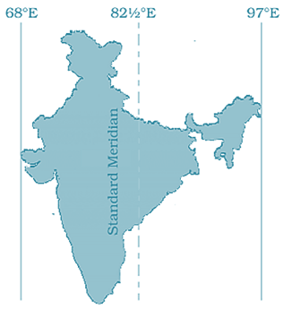
- India’s standard meridian is 82.5° E (near Mirzapur, Uttar Pradesh).
- London (Greenwich) is at 0° longitude.
👉 Time difference = 82.5/15=5.5 hours.
✅ So, when it is 12:00 noon in London,
⏰ it is 5:30 PM in India.
🌎 Example 2: New York vs Tokyo
- New York is approximately 75° W.
- Tokyo is approximately 135° E.
👉 Total longitude difference = 75° + 135° = 210°
👉 Time difference = 210/15=14 hours.
✅ So, when it is 8:00 AM in New York,
⏰ it is 10:00 PM in Tokyo (same day).
🌐 Example 3: Flying from Delhi to Sydney
- Delhi is at 77° E
- Sydney is at 151° E
👉 Longitude difference = 151 – 77 = 74°
👉 Time difference = 74/15≈5 hours.
✅ So, if it’s 2:00 PM in Delhi,
⏰ it will be 7:00 PM in Sydney.
Standard Time and Time Zones
To avoid confusion, countries adopt Standard Time based on a central meridian.
Standard Time
- Standard Time is the official time adopted by a country based on a selected longitude.
- Example: Indian Standard Time (IST) is based on 82.5° E longitude (near Prayagraj, Uttar Pradesh).
- IST = GMT+5:30 (5 hours 30 minutes ahead of Greenwich).
Time Zones in Large Countries
- Countries with large east-west extents cannot follow a single time zone.
- Russia has 9 time zones, and Canada & USA have 6 time zones each.
- If India followed multiple time zones, Assam’s sunrise would be too early compared to Gujarat.
The International Date Line (IDL): When a New Day Begins
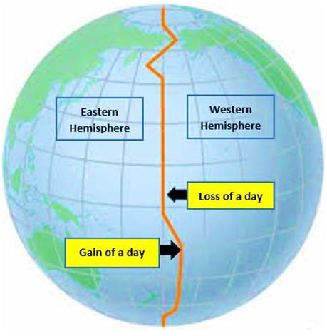
The International Date Line (IDL) is an imaginary line at 180° longitude in the Pacific Ocean.
What Happens When You Cross the IDL?
- If you travel eastward across the IDL, you gain a day.
- If you travel westward across the IDL, you lose a day.
- This ensures that calendar dates remain consistent worldwide.
🔄 Rule of Thumb:
🧭 When crossing the IDL…
| Direction | What Happens? | Why? |
| 👉 Eastward (e.g., Japan → USA) | You go back a day | You enter a region that’s a day behind |
| 👈 Westward (e.g., USA → Japan) | You skip ahead a day | You enter a region that’s a day ahead |
🎓 But Why Does This Happen?
Because the Earth is divided into 24 time zones, each about 15° apart, and the total time difference across the globe is 24 hours.
- So, when you travel east, you’re moving ahead in time — keep doing this and eventually you’re a full 24 hours ahead.
- To keep the calendar in sync, we subtract a day when you cross the IDL eastward.
And when going west, you’re going back in time, so to sync the date, we add a day
✈️ Real-Life Travel Example:
Flying from Tokyo (Japan) to Honolulu (Hawaii):
- You cross the IDL eastward.
- If you leave Tokyo at 8 AM on Monday,
you’ll land in Honolulu at 9 PM on Sunday. - You gain a day.
How?
- Suppose today is Monday morning (8:00 AM) in Tokyo.
- You board a flight to Honolulu, which takes approximately 7–8 hours.
🕒 Tokyo is UTC +9,
🕒 Honolulu is UTC –10.
👉 So there is a 19-hour time difference (Tokyo is 19 hours ahead of Honolulu).
Now subtract 19 hours from 8:00 AM Monday (Tokyo time):
- 8:00 AM Monday (Tokyo)
- Minus 19 hours = 1:00 PM Sunday (Honolulu)
✅ Even though you flew for 8 hours, you land in Honolulu on Sunday at 9:00 PM, the day before you left. That’s why we say you “gain” a day.
Flying from Honolulu to Tokyo:
- You cross the IDL westward.
- You leave at 7 PM on Sunday,
you land in Tokyo at 10 PM on Monday. - You lose a day.
How?
- Suppose you take off from Honolulu at 7:00 PM on Sunday.
- Flight duration: about 8 hours to Tokyo.
- 🕒 Honolulu is UTC –10,
- 🕒 Tokyo is UTC +9.
- 👉 That’s a +19 hour jump forward in time.
- 7:00 PM Sunday + 12 hours = 7:00 AM Monday
- Add 7 more hours = 2:00 PM Monday (Tokyo)
- But since the flight took 8 hours, your actual arrival time will be closer to 10:00 PM on Monday in Tokyo.
- ✅ You left Honolulu on Sunday evening, but landed in Tokyo on Monday night you “lost” an entire day on the calendar
How This LINE Divides Earth in Day & Night? | The International Date Line
Why is the IDL Zigzagged?
- The IDL is not a straight line; it is zigzagged to avoid splitting countries and island groups into different date zones.
- Example: Kiribati moved its time zone to be the first to enter the New Year!
Who Celebrates the New Year First & Last?
- First places: Samoa, Christmas Island (Kiribati), Tonga.
- Last places: Baker Island (USA), Howland Island (USA).
Final Thought: Why Are Longitudes Important?
Longitudes are more than just mapping tools. They define time zones, business hours, and even historical events. From the Greenwich Prime Meridian to the zigzagging International Date Line, longitudes shape how we experience time on Earth!
Comparing Latitudes and Longitudes
| Feature | Latitude | Longitude |
|---|---|---|
| Definition | Angular distance measured north or south of the Equator | Angular distance measured east or west of the Prime Meridian |
| Direction | Runs horizontally (east-west) | Runs vertically (north-south) |
| Also Called | Parallels | Meridians |
| Key Reference Line | Equator (0°) | Prime Meridian (0°) |
| Length | Different lengths (Equator is longest, lengths decrease toward poles) | All are equal in length |
| Important Ones | Equator, Tropic of Cancer, Tropic of Capricorn, Arctic Circle, Antarctic Circle | Prime Meridian, International Date Line |
| Function | Determines climate zones | Determines time zones |
| How They Help? | Helps find how far north or south a place is | Helps find how far east or west a place is |

One Comment