
Agroecological Region
Imagine you’re planning a garden. You don’t just look at the weather—you also check the soil, water availability, and how long your plants will survive before winter comes. Similarly, an Agroecological Region (AER) is not just about climate. It combines climate, soil, and the length of the growing period (LGP)—how long conditions remain suitable for crops.
So, AER = Climate + Soil + LGP
This concept was introduced globally by FAO, and in India, it was adopted and fine-tuned by NBSS&LUP, which is under ICAR. The idea? Not just to grow more, but to grow better and sustainably.
NBSS&LUP stands for National Board of Soil Survey and Land Use Planning
ICAR stands for Indian Council of Agricultural Research
🧩 Key takeaway: AERs aim to align natural resources with appropriate agricultural practices—so that land isn’t exploited, and agriculture becomes more efficient and climate-resilient.
🔄 Agroecological Zone vs. Agro-Climatic Zone
Let’s say you’re choosing between two reports:
- One tells you the weather and rainfall (Agro-Climatic Zone – ACZ).
- The other tells you weather, soil fertility, and how long you can grow a crop (Agroecological Zone – AEZ).
| Criteria | AEZ (Agroecological Zone) | ACZ (Agro-Climatic Zone) |
|---|---|---|
| Focus | Climate + Soil + LGP | Mainly climate and rainfall |
| Defined by | NBSS&LUP (ICAR) | Planning Commission + ICAR |
| No. in India | 20 AERs (60 sub-regions) | 15 ACZs |
| Use | Soil management, sustainable land use | Macro-level planning |
| Detail | Micro-level, technical | Broader, general |
🧠 Remember: AEZ is more precise and scientific—used where detailed crop planning and resource management are needed.
📊 Criteria Used for Delineation of AERs
Let’s decode how AERs are carved out.
a. Rainfall
- Like water to life, rainfall dictates what we can grow.
- Affects irrigation needs and determines whether a region is arid, semi-arid, sub-humid, or humid.
b. Temperature
- Think of crops like humans—some like it hot (like cotton), some don’t.
- Temperature impacts crop growing duration, frost sensitivity, and heat tolerance.
c. Soil Type
- Just like we have different personalities, soils have different properties.
- Black, red, alluvial, lateritic—each has unique nutrient content, drainage, and erosion risks.
d. Length of Growing Period (LGP)
- Defined as number of days in a year when temperature and moisture are suitable for crop growth.
| LGP Range | Zone Type |
|---|---|
| <90 days | Arid |
| 90–150 days | Semi-arid |
| 150–210 days | Sub-humid |
| >210 days | Humid |
📌 Think of LGP as a calendar telling farmers how long their crop party can last 😊
🗺️ Classification by ICAR/NBSS&LUP
NBSS&LUP identified 20 major AERs in India, based on:
- Bioclimatic zones
- Soil types
- Length of Growing Period
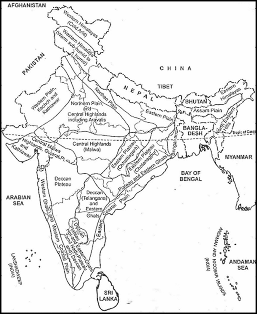
Arid Ecosystem
| Region | States Covered | Climate & Rainfall | Soils & LGP | Crops & Vegetation | Major Constraints |
|---|---|---|---|---|---|
| 1. Western Himalayas, Cold Arid | Ladakh, Gilgit | Mild summer, severe winter; <150 mm rainfall | Cryic, calcareous soils; LGP < 90 days | Vegetables, apple, apricot; sparse forest | Severe cold, short growing season, shallow soils |
| 2. Western Plain, Kachchh & Kathiawar (Hot Arid) | Punjab, Haryana (SW), Rajasthan (W), Gujarat (Kachchh & N. Kathiawar) | Hot summer, cool winter; <400 mm rainfall | Sandy, calcareous, alkaline soils; LGP < 90 days | Pearl millet, pulses; cotton, wheat (irrigated); thorn forest | Erratic rainfall, salinity, nutrient imbalance |
| 3. Deccan Plateau (Hot Arid) | Karnataka (Bellary, Bijapur, Raichur), Andhra Pradesh (Anantapur) | Hot & dry; 400–500 mm rainfall | Red loamy & black soils; LGP < 90 days | Sorghum, safflower, groundnut (rainfed); cotton, sugarcane (irrigated); thorn forest | Drought, erosion, dry spells |
Semi-Arid Ecosystem
| Region | States Covered | Climate & Rainfall | Soils & LGP | Crops & Vegetation | Major Constraints |
|---|---|---|---|---|---|
| 4. Northern Plain & Aravalli’s (Hot Semi-Arid) | Gujarat, Central Highlands, Bundelkhand, N. Plains | Hot summer, cool winter; 500–1000 mm rainfall | Loamy soils; LGP 90–150 days | Rice, wheat, maize, mustard, sugarcane (irrigated); dry deciduous forest | Groundwater overuse, soil salinity, low water holding |
| 5. Central Highlands, Gujarat Plains & Kathiawar | MP (Malwa), SE Rajasthan, Gujarat | Hot, wet summer; dry winter; 500–1000 mm rainfall | Deep black soils; LGP 90–150 days | Sorghum, pulses, soybean, wheat (irrigated); dry deciduous forest | Salinity, dry spells, sea water intrusion (Kathiawar) |
| 6. Deccan Plateau (Hot Semi-Arid) | Maharashtra (C & W), Karnataka (N), Andhra Pradesh (W) | Hot & humid summer, mild winter; 600–1000 mm | Loamy & clayey soils; LGP 90–150 days | Sorghum, pigeonpea, pearl millet (rainfed); cotton, groundnut (irrigated); dry deciduous & thorn forest | Dry spells, soil loss from runoff, nutrient deficiency (N, P, Zn) |
| 7. Telangana & Eastern Ghats (Hot Semi-Arid) | Telangana, Andhra Pradesh (E. Ghats) | Hot & moist summer, mild winter; 600–1100 mm | Black (alkaline, clayey) & Red (neutral) soils; LGP 90–150 days | Sorghum, cotton, rice, groundnut, castor; dry deciduous & thorn forest | Runoff, salinity in black soils, nutrient imbalance, frequent droughts |
| 8. Eastern Ghats & TN Uplands (Hot Semi-Arid) | Tamil Nadu (uplands), Karnataka (W), E. Ghats | Hot, dry summer; mild winter; 600–1000 mm | Red loamy soils; LGP 90–150 days | Millets, pulses, groundnut (kharif); sorghum, safflower (rabi); irrigated rice, sugarcane, cotton | Soil erosion, nutrient deficiency (N, P, Zn) |
Sub-humid Ecosystem
| Region | States Covered | Climate & Rainfall | Soils & LGP | Crops & Vegetation | Major Constraints |
|---|---|---|---|---|---|
| 9. Northern Plain (Hot Subhumid Dry) | Indo-Gangetic Plain (W), Himalayan piedmont | Hot summer, cool winter; 1000–1200 mm | Deep, loamy alluvial soils; LGP 150–180 days | Rice, maize, jute (kharif); wheat, mustard (rabi); sugarcane, cotton (irrigated); dry deciduous forest | Water-logging & salinity due to improper irrigation |
| 10. Malwa, Bundelkhand (Hot Subhumid Dry) | MP (Malwa, Bundelkhand), parts of Maharashtra | Hot summer, mild winter; 1000–1500 mm | Red & Black soils; LGP 150–180 days | Rice, soybean, sorghum (kharif); wheat, gram, vegetables (rabi); moist deciduous forest | Droughts, water stagnation, soil runoff, nutrient imbalance (N, P, Zn) |
| 11. Chhattisgarh / Mahanadi Basin | Chhattisgarh, SW Bihar | Hot sub-humid; 1200–1600 mm (70–80% in monsoon) | Red & yellow soils; LGP 150–180 days | Rice, millets, pulses (kharif); irrigated wheat, rice (rabi); moist deciduous forests | Water erosion, partial waterlogging & seasonal drought, nutrient deficiency (N, P, Zn, B) |
| 12. Chhotanagpur & E. Ghats | Jharkhand, W Bengal, Odisha (Dandakaranya), S Chhattisgarh | Hot sub-humid; 1000–1600 mm | Acidic loamy to clayey soils; shallow on ridges, deep in valleys; LGP 150–210 days | Rice, pulses, groundnut (rainfed); irrigated wheat & rice (rabi); dry/moist deciduous forests | Soil erosion, seasonal drought, nutrient deficiency (N, P, Zn, B) |
| 13. Eastern Plains (U.P. & Bihar) | NE Uttar Pradesh, N Bihar, Central Himalayan foothills | Hot, wet summer; cool, dry winter; 1400–1800 mm | Gently sloping alluvial soils; LGP 180–210 days | Rice, maize, pulses (kharif); wheat, lentil, peas (rabi); sugarcane, chillies, turmeric (irrigated); moist/dry deciduous forests | Flooding, poor drainage, salinity/sodicity patches, nutrient imbalance (N, P, Zn) |
| 14. Western Himalayas | J&K, Himachal Pradesh, NW Uttarakhand | Warm sub-humid to humid/perhumid; 1000–2000+ mm | Brown Forest & Podzolic soils; high OM; LGP varies by altitude | Wheat, maize, millets, rice; apples, horticulture on terraces; moist temp., pine & sub-alpine forests | Cold climate limits crops, erosion from steep slopes, landslides, soil acidity (Kangra, Manali) |
Humid- per humid ecosystem
| Region | State Covered | Climate and Rainfall | Soils and LGP | Crops and Vegetation | Major Constraints |
|---|---|---|---|---|---|
| 15. Assam & Bengal Plains | Assam, West Bengal | Hot summer, mild winter; Rainfall: 1400–2000 mm+ | Alluvial soils; LGP > 210 days | Rice, jute (rainy season); tea, pineapple, banana in foothills; moist & dry deciduous forests | Flooding, waterlogging, nutrient leaching (low base status in Brahmaputra plains) |
| 16. Eastern Himalayas, Warm Perhumid Eco-Region | Arunachal Pradesh, Sikkim, Northern Assam, Northern West Bengal | Warm summer, cool winter; 2000 mm annual rainfall; short water stress in post-rainy period | Shallow to deep loamy Brown Forest soils; high organic matter; LGP > 270 days | Jhum cultivation on slopes; millets, maize, potato, paddy in valleys; plantation crops (tea), fruits (pineapple, citrus, banana); subtropical pine and temperate wet evergreen forests | Severe erosion from runoff on steep slopes; soil degradation from deforestation; nutrient leaching; water stagnation in valleys; cold post-monsoon restricts second cropping |
| 17. North-Eastern Hills (Purvanchal), Warm Perhumid Eco-Region | Nagaland, Meghalaya, Manipur, Mizoram, South Tripura | Warm summer, cool winter; 2000–3000 mm rainfall | Shallow to deep red, yellow and lateritic soils; LGP > 270 days | Jhum cultivation; rice in valleys; maize, millets, potato on terraces; tea, coffee, rubber, pineapple, oranges; wet evergreen and moist deciduous forests | Soil erosion from deforestation and shifting cultivation; nutrient leaching; small land holdings limit mechanization |
Coastal Ecosystem
| Region | State Covered | Climate and Rainfall | Soils and LGP | Crops and Vegetation | Major Constraints |
|---|---|---|---|---|---|
| 18. Eastern Coastal Plain, Hot Subhumid to Semiarid Eco-Region | Coastal Tamil Nadu, Andhra Pradesh, Odisha, West Bengal | Sub-humid to semi-arid; rainfall 900–1600 mm (mostly Jun–Sep or Oct–Dec depending on region) | Red/lateritic & alluvial soils; LGP 90–210 days depending on region | Rice (kharif & rabi), coconut, pulses (black gram, lentil), oilseeds (sunflower, groundnut), brackish fisheries; tropical coastal vegetation | Salinity/sodicity from poor drainage; cyclone-prone; uneven rainfall and soil variability |
| 19. Western Ghats and Coastal Plain, Hot Humid-Perhumid Eco-Region | Maharashtra, Karnataka, Kerala, Tamil Nadu (Nilgiris) | Hot, humid summer; warm winter; >2000 mm rainfall | Red/lateritic soils on slopes, alluvial in plains; LGP 150–210+ days | Rice, tapioca, coconut, spices; tropical moist deciduous forests | Nutrient leaching; waterlogging in plains; steep slope erosion; coastal inundation and saline marshes |
Island Ecosystem
| Region | State Covered | Climate and Rainfall | Soils and LGP | Crops and Vegetation | Major Constraints |
|---|---|---|---|---|---|
| 20. Islands of Andaman-Nicobar and Lakshadweep, Hot Humid to Perhumid Island Ecoregion | Andaman & Nicobar Islands, Lakshadweep | Tropical climate; 1600 mm (Lakshadweep) to 3000 mm (Andaman); humid to perhumid | Red loamy & marine soils (Andaman), calcareous sandy soils (Lakshadweep); LGP > 210 days | Rice, coconut, arecanut, pineapple, tapioca, pepper; rainforests, littoral and swamp forests | Soil erosion from deforestation; saline marshes and acid sulfate soils from coastal inundation; mangrove expansion indicating coastal degradation |
🌾 Significance of Agroecological Regions
a. Land-Use Planning
- AERs provide a scientific basis for choosing crops suited to that region.
- Prevents misuse of fragile ecosystems, e.g., growing water-intensive rice in arid areas.
b. Crop Suitability Analysis
- Helps match right crop to right place = higher yield with fewer inputs.
- E.g., cotton in black soil, tea in hilly humid zones.
c. Sustainable Agriculture
- Encourages practices like zero tillage, mulching, and crop rotation that conserve soil and water.
🏛️ Applications in Policy and Development
AER-based strategies are now influencing key agricultural and environmental schemes:
| Area | Use |
| Irrigation | Efficient planning based on LGP |
| Fertilizer Use | Soil-type-specific application |
| Climate Risk | Better crop insurance, early warnings |
| PM-KUSUM | Targeted use of solar irrigation |
| Soil Health Card | Tailored nutrient advice per zone |
| Integrated Farming | Compatible systems (crops + livestock + forestry) |
🎯 Point to note: These applications make AER a practical tool, not just a theoretical model.
🛰️ Recent Tools in Agroecological Mapping
Technology is the new plough—helping us understand, map, and manage agroecological zones better.
a. Remote Sensing (RS)
- Think of it like satellite “CCTV” for crops—tracking rainfall, vegetation health (NDVI), droughts.
b. GIS (Geographical Information System)
- Combines layers of data (soil + rainfall + slope) to create precise farming maps.
c. Crop Simulation Models
- Models like DSSAT or WOFOST simulate how crops would perform in various conditions.
d. Bhuvan & Soil Grids
- Platforms offering real-time spatial data on soil and climate—great for policy and local farm decisions.
🧠 Prelims Pointers (Quick Facts)
- NBSS&LUP (HQ: Nagpur) = Nodal agency for AERs.
- LGP = Key factor in defining AERs.
- GIS + RS = Backbone of modern AER mapping.
Agroecological Regions help us understand not just where crops can be grown, but where they should be grown— sustainably, scientifically, and sensibly.