
Convergent Boundary
🌋 Ocean–Ocean Convergence (O–O Convergence)
aka Island Arc Convergence
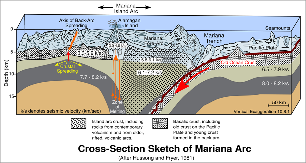
We have already studied in earlier sections that at an O–O convergent boundary, two oceanic plates collide. Since both are made of oceanic crust, the denser of the two (usually older, colder, and heavier) subducts beneath the other.
🧠 Just like continental convergence forms Himalayas, oceanic convergence forms Island Arcs.
🧭 Where does this happen?
O–O convergence is responsible for the formation of:
- 🇯🇵 Japanese Island Arc
- 🇮🇩 Indonesian Archipelago
- 🇵🇭 Philippine Island Arc
- 🌴 Caribbean Islands
These are regions with:
- Deep oceanic trenches
- Frequent earthquakes
- Chain of volcanic islands (called Island Arcs)
🔷 Step-by-Step Process: How Are Island Arcs Formed?
Let’s break it into simple steps:
🌀 1. Subduction Initiation
- A denser oceanic plate begins to subduct below a less dense oceanic plate.
- This forms a deep oceanic trench (e.g., Japan Trench, Philippine Trench, Sunda Trench).
🔥 2. Metamorphism & Magma Generation
- At ~100 km depth, high pressure and temperature cause:
- Metamorphism of rocks
- Melting of sediments + plate material
- This generates andesitic magma (intermediate in silica content).
🎈 3. Magma Ascent & Volcanism
- The magma is hot and less dense, so it rises through the crust.
- It erupts on the ocean floor → layer upon layer → volcanic mountains.
🏝️ 4. Formation of Island Arc
- These volcanic peaks emerge above sea level, forming a chain of volcanic islands.
- This curved chain is called an Island Arc.
🧱 5. Orogenesis (Mountain Building)
- Over time, the islands merge, and oceanic crust slowly transforms into continental crust.
- This begins the process of continent building in the long run.
📌 UPSC Note:
Island Arcs are the oceanic equivalents of Fold Mountains in continent–continent convergence.
🌍 Key Island Arcs Formed by O–O Convergence
Let’s understand the important cases with involved tectonic plates and trenches:
🇵🇭 Philippine Island Arc
| Feature | Description |
| Converging Plates | Philippine Sea Plate subducts beneath Sunda Plate (Eurasian) |
| Trench | Philippine Trench |
| Type | Classic Island Arc with volcanic origin |
📝 Sunda Shelf = A shallow, submerged part of the Eurasian Plate covering Java, Sumatra, Borneo, etc.
🇮🇩 Indonesian Archipelago
| Feature | Description |
| Converging Plates | Indo-Australian Plate subducts beneath Sunda Plate |
| Trench | Sunda Trench (includes Java Trench) |
🇯🇵 Japanese Island Arc
Japan is formed by three arcs; each linked to a different plate boundary:
| Arc | Subduction Interaction | Trench |
| Northern | Pacific Plate under Eurasian Plate | Japan Trench |
| Central | Pacific Plate under Philippine Plate | Izu Trench |
| Southern | Philippine Plate under Eurasian Plate | Ryukyu Trench |
- These arcs meet at a triple junction on Honshu Island.
- The eastward tilt of the arc system created the Sea of Japan.
🌴 Caribbean Islands
| Feature | Description |
| Converging Plates | South American Plate subducts under Caribbean Plate (eastern margin) |
| Result | Volcanic islands of the Lesser Antilles (e.g., Mount Pelée) |
| Mount Pelée | Deadliest Caribbean volcano (killed ~30,000 in 1902) |
🌉 Formation of the Isthmus of Panama
- Caused by subduction of the Pacific–Farallon Plate beneath Caribbean and South American Plates
- Led to:
- Panama Arc (volcanic origin)
- Collision with South America → uplift → Isthmus of Panama
- Result: Connection between North and South America formed; major biogeographic event.
🧠 Interesting: The Farallon Plate has since broken into smaller plates:
- Cocos Plate
- Nazca Plate
- Juan de Fuca Plate
The Mariana Trench
| Feature | Description |
| Plates Involved | Pacific Plate subducting beneath Mariana Plate |
| Depth | ~11,000 metres (deepest known point: Challenger Deep) |
| Fun Fact | Not the point closest to Earth’s center — due to Earth’s geoid shape! |
Difference Between Island Arc and Archipelago
| Term | Meaning | Example |
| Island Arc | Curved chain of volcanic islands along O–O subduction zone | Japanese Islands, Philippines |
| Archipelago | Large group of islands (not always volcanic) | Malay Archipelago, Indonesia |
🌄 Continent–Ocean Convergence (C–O Convergence)
Also called Cordilleran Convergence
Why is it called Cordilleran?
The word Cordillera refers to a chain of mountains or a system of parallel mountain ranges near continental margins.
So, whenever a continent and an oceanic plate converge, and this collision creates massive coastal mountain systems, we call it Cordilleran Convergence.
🗻 Examples of such mountains:
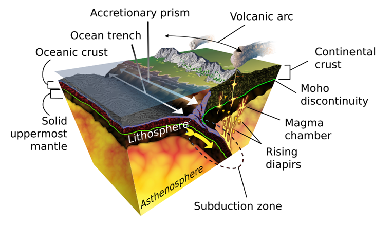
What Happens During C–O Convergence?
🌊 1. Subduction Begins
- When an oceanic plate collides with a continental plate, the denser oceanic plate subducts beneath the lighter continental plate.
- This creates a subduction zone, often marked by a trench near the continental margin.
🧠 Example: Nazca Plate subducts below South American Plate → Peru-Chile Trench
🔥 2. Formation of Magma and Volcanism
- As the subducting oceanic plate sinks, it heats up and undergoes partial melting.
- This produces andesitic magma (silica-rich), which rises through the continental crust.
- The magma erupts, forming volcanic mountains on the continent (not in the ocean like O–O convergence).
This linear chain of volcanoes formed on the continental edge is called a Continental Arc.
🧨 Examples:
- Cascade Range (USA, west of the Rockies)
- Western Chile Range (parallel to Andes)
🪨 3. Formation of Accretionary Wedge
- The subducting oceanic plate carries sediments scraped from the ocean floor.
- These sediments accumulate at the trench and compress into a wedge-shaped mass called the Accretionary Wedge/Prism.
- This wedge adds compressive force and thickens the continental margin.
📌 Concept:
👉 Crustal Shortening at convergence = Crustal Widening at divergence (a tectonic balance)
🏔️ 4. Formation of Fold Mountains — Orogeny
Here’s where things get really interesting from a UPSC Mains perspective:
- Orogeny = Mountain building process due to lateral compression.
- As the accretionary wedge and crustal sediments are compressed, they fold, fault, and metamorphose.
- The continental edge rises, creating Fold Mountains (Orogenic belts).
🧠 Why near the coast? Because that’s where the continental plate meets the subducting oceanic plate.
✳️ Key Landforms from C–O Convergence
🇨🇱 The Andes Mountains
| Feature | Description |
| Plates Involved | Nazca Plate (oceanic) + South American Plate (continental) |
| Trench | Peru-Chile Trench |
| Result | Continental Arc + Fold Mountains |
| Notable Volcano | Ojos del Salado (6,893 m, highest active volcano on Earth) |
| Highest Peak | Mount Aconcagua (6,960 m, extinct volcano) |
- Western Chile Range was separated from the Andes due to a depression called Intermediate Depression.
- Volcanism is still active, indicating that orogeny is ongoing.
🇺🇸 The Rocky Mountains
| Feature | Description |
| Plates Involved | Pacific & Juan de Fuca Plates (oceanic) + North American Plate |
| Result | Fold mountains at a distance from coast (unlike Andes) |
| Reason | Shallow subduction angle + presence of fault zones like San Andreas |
- Formed inland, not along the exact coastal edge.
- Subduction is not steep, hence magma doesn’t erupt easily, and trenching is less obvious.
🔁 Final Stage: Isostatic Adjustment
After orogeny, what happens?
- With time, erosion wears down mountain peaks.
- The earth’s crust undergoes isostatic rebound:
- Heavier/denser regions sink
- Lighter ones rise
This exposes the roots of the mountain belt, as seen in ancient ranges like the Rockies.
🧠 Important UPSC Concepts
✅ Arc vs Fold Mountain
| Term | Meaning | Example |
| Island Arc | Volcanic islands in oceanic region | Japan, Indonesia |
| Continental Arc | Volcanic mountains on continents | Andes, Cascade Range |
| Fold Mountains | Compressed, folded sedimentary layers | Himalayas, Rockies, Andes |
✅ Terminologies
| Term | Meaning |
| Accretionary Wedge | Accumulated oceanic sediments at trench compressed onto continental plate |
| Crustal Shortening | Horizontal compression at convergence zones |
| Isostasy | Vertical adjustment of crust based on load balance (e.g., erosion, uplift) |
🏔️ Continent–Continent Convergence (C–C Convergence)
Also known as the Himalayan Convergence type
Why subduction fails in C–C convergence?
- Continental crust is too buoyant (lower density) to be subducted into the mantle like oceanic crust.
- Even if one of the plates starts to descend, subduction stops around 40–50 km depth.
- Instead of deep trenches, the crust buckles, folds, and faults, creating massive fold mountain systems.
🧠 Key Concept: Instead of “subduction → volcanism” (as in O–O or C–O), here we have “compression → uplift → folding”.
🪨 What happens during C–C convergence?
🧱 1. Collision and Suture Formation
- The two continental plates meet and collide.
- Any oceanic crust between them (e.g., Tethys Sea) is consumed.
- Fragments of this oceanic crust are welded between the plates — this weld is called the Suture Zone.
🧠 Example:
Indus–Tsangpo Suture Zone in the Himalayas.
🌊 2. Squeezing of Sedimentary Basin
- Geosynclinal sediments (accumulated over millions of years in the Tethys) are trapped between the converging plates.
- They get compressed, folded, and faulted, forming a towering fold mountain belt.
📌 Important: These sediments include marine fossils — for example, marine limestone found at the summit of Mount Everest!
🏞️ 3. Formation of Fold Mountains and Uplifted Plateau
- Massive compression causes uplift of crust, creating:
- A fold mountain chain (Himalayas)
- An uplifted plateau behind the collision zone (Tibetan Plateau)
🧠 Why is the Tibetan Plateau higher than the Indian side?
Because India’s crust was more firmly attached to the oceanic base, while Asia’s block was more flexible and got pushed upward.
⛰️ 4. Crustal Shortening & Isostatic Adjustment
- Collision causes crustal shortening (500 km in Himalayas!).
- This shortening is compensated by crustal widening elsewhere (e.g., sea-floor spreading in the Indian Ocean).
- Erosion of mountains leads to isostatic uplift (like floating icebergs — lighter areas rise).
🌏 Case Study: Formation of the Himalayas
Explained in Indian Geography Section. Read here
🌍 Other Fold Mountains Formed by C–C Convergence
| Mountain Range | Plates Involved | Type | Notes |
| Himalayas | Indian Plate ↗ Eurasian Plate | Young Fold | Active, highest mountain range |
| Alps | African Plate ↗ Eurasian Plate | Young Fold | Active, in Europe |
| Atlas | African Plate ↗ Eurasian Plate | Young Fold | In North Africa, still rising |
| Urals | Europe ↗ Asia (ancient plates) | Old Fold | ~300 mya, very weathered |
| Appalachians | North America ↔ Europe (before Pangaea breakup) | Old Fold | Ancient, heavily eroded |
🌋 Why No Volcanoes in C–C Convergence?
| Reason | Explanation |
| Thick continental crust (50–70 km) | Magma cannot pierce this thick, buoyant crust |
| Lack of subduction beyond 40–50 km | No melting zone like in O–O or C–O convergence |
| Result | No active volcanoes, but frequent earthquakes |
| Common Rock Type | Metamorphic rocks (formed under pressure) |
3 Comments