
Major Glaciers of Himalayas
Snow in the Himalayas: The Snowline
Have you ever wondered why some mountains are covered in snow year-round, while others remain bare? The answer lies in a concept called the snowline.
What is the Snowline?
The snowline is the altitude above which snow remains throughout the year. It marks the boundary between the permanently snow-covered region and the lower areas where snow melts seasonally.
In the Himalayas, the snowline is not uniform; it varies depending on:
- Latitude (Distance from the Equator)
- Precipitation (Amount and Type of Snowfall/Rainfall)
- Slope Orientation (Southern vs. Northern Slopes)
Snowline Variation in the Himalayas
1. Snowline in Eastern vs. Western Himalayas
- In the Eastern Himalayas (e.g., Kumaon, Sikkim, Arunachal Pradesh), the snowline is at a higher altitude of about 3,500 meters above sea level.
- In the Western Himalayas (e.g., Kashmir, Ladakh, Himachal Pradesh), the snowline is lower, at around 2,500 meters.
👉 Why is there a difference?
- Latitude Effect: The latitude increases from 28°N in Kanchenjunga to 36°N in Karakoram, meaning the western Himalayas are farther from the equator and generally colder.
- Precipitation Factor: The Eastern Himalayas receive more precipitation (mostly as rain due to the warm, humid monsoon winds), while the Western Himalayas get less precipitation, but it mostly falls as snow due to colder temperatures.
2. Snowline on Southern vs. Northern Slopes
- In the Great Himalayan ranges, the snowline is lower on the southern slopes than on the northern slopes.
- Why?
- Southern slopes are steeper and receive more precipitation, especially from the southwest monsoon.
- The northern slopes are in the rain shadow, meaning they receive less precipitation and therefore have a higher snowline.
Major Glaciers in the Himalayas
What is a Glacier?
- A glacier is basically a “river of ice”. It forms when snow keeps accumulating year after year in a region, doesn’t melt fully in summers, and gradually transforms into dense glacial ice.
- Technically, it’s made of:
- Crystalline ice (the solid ice formed after metamorphism of snow),
- Snow,
- Rock and sediments,
- And sometimes even liquid water.
- Now, due to gravity, this huge mass cannot sit still. It begins to creep downslope slowly but continuously.
👉 Important: This is why glaciers are called dynamic systems. They are not static blocks of ice, but slow-moving bodies shaping the landscape.
Extent of Glaciers in the Himalayas
- According to ISRO’s study:
- There are 34,919 glaciers in the Indus, Ganga, and Brahmaputra basins.
- Together, they cover about 75,779 sq. km.
- This includes the Himalaya, Trans-Himalaya, and the Karakoram region.
👉 So, the Himalayas are not just mountains – they’re also one of the biggest freshwater reservoirs of the world, often called the “Third Pole” after the Arctic and Antarctic.
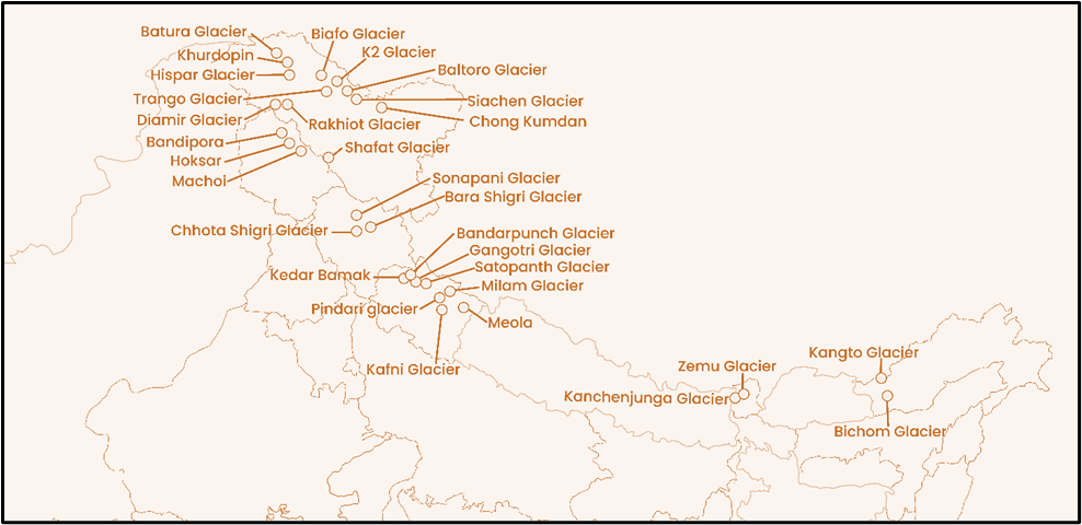
Glaciers of the Karakoram Range
- The Karakoram is the king when it comes to glacier development in the Himalayas.
- Why? Because it has the largest glaciers outside the polar regions.
- On the southern slopes of Karakoram, we find huge glaciers.
Important Glaciers here:
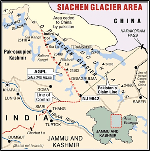
- Siachen Glacier
- Length: 75 km.
- Location: Nubra Valley (Nubra River is a tributary of Shyok River).
- Significance: Largest glacier outside the poles.
- Hispar Glacier
- Length: 62 km.
- Lies in the Hunza River’s tributary valley.
👉 For comparison: The Fedchenko Glacier in Pamir mountains (Tajikistan) is 74 km long, the 2nd largest outside poles.
Glaciers of the Pir Panjal Range
- Much smaller and fewer compared to Karakoram.
- The longest here: Sonapani Glacier – just 15 km long.
- Location: Chandra Valley, Lahul and Spiti (Himachal Pradesh).
Glaciers of Ladakh
Siachen Glacier (Special Focus)
- Located in Ladakh, near Karakoram Pass.
- Type: Piedmont Glacier → forms when a valley glacier comes down and spreads over a flat area at the mountain’s base.
- Origin: At the base of Indira Col West.
- It lies between Saltoro Ridge (sub-range of Karakoram) and the main Karakoram Range.
- Significance:
- World’s highest battleground (India–Pakistan conflict zone).
- Temperatures: Drop to -50°C.
- Source of Nubra River, which joins Shyok → finally Indus.
- The broader region is called the Third Pole because:
- Himalayas + Karakoram + Hindu Kush + Tibetan Plateau together form the largest non-polar ice mass.
Other Important Karakoram Glaciers (mostly in PoK)
- K2/Godwin-Austen Glacier – near K2 peak (world’s 2nd highest).
- Biafo Glacier – drains into Shigar River → Indus.
- Baltoro Glacier – source of Braldo River → Shigar → Indus.
- Hispar Glacier – merges with Biafo at Hispar La Pass (5,128 m) → forms longest glacial system outside poles. It feeds Hispar River → Hunza → Indus.
- Khurdopin Glacier – source of Shimshal River → Hunza → Indus.
- Others: Rakhiot, Diamir, Trango etc.
Glaciers of the Zanskar Himalayas
- Machoi Glacier – Drass region, near Zoji La. Source of Sind River (tributary of Jhelum) and Drass River (tributary of Shingo → Suru).
- Drang-Drung Glacier – near Pensi La Pass, source of Doda River (largest tributary of Zanskar River).
- Shafat Glacier – feeds Suru River.
- Pensilungpa Glacier – NW Zanskar Valley, also feeds Suru River.
Other Notable Glaciers
- Chong Kumdan – on lower slopes of Karakoram range, feeds Shyok River.
- Rimo Glacier – also in Karakoram, source of Shyok River.
Glaciers of Jammu & Kashmir
- Kolahoi Glacier
- Location: Near Pahalgam, Kashmir.
- Significance: Highest and largest glacier in Kashmir.
- Source of Lidder River → tributary of Jhelum.
- Thajiwas Glacier
- Location: Ganderbal district (famous tourist site near Sonmarg).
- Harmukh Glacier
- Location: Ganderbal district, near Gangabal Lake (also called Haramukh Ganga).
- Linked to Harmukh Peak region.
👉 Notice: Most J&K glaciers ultimately feed into the Jhelum system, making them crucial for Kashmir Valley’s rivers.
Glaciers of Himachal Pradesh (HP)
In Himachal Pradesh, glaciers are locally called “Shigri.”
HP has several glaciers in Pir Panjal and Greater Himalayas.
Major Glaciers in Himachal Pradesh
- Bara Shigri Glacier
- Location: Lahaul region.
- Largest glacier in Himachal Pradesh.
- Feeds the Chandra River → merges with Bhaga at Tandi → forms Chandrabhaga / Chenab.
- Fun fact: Ancient name of Chenab = Askini.
- Beas Kund (Glacial Lake)
- Location: Near Rohtang Pass, Kullu district (Pir Panjal Range).
- Source of Beas River → tributary of Sutlej.
- Chhota Shigri Glacier
- Location: Near Rohtang Pass, in Lahaul-Spiti Valley (Pir Panjal Range).
- Feeds the Chandra River.
- Suraj Tal (Tso Kamtsi)
- Location: Near Baralacha Pass, Lahaul-Spiti.
- Source of Bhaga River → joins Chandra at Tandi → forms Chenab.
- Bhadal Glacier
- Location: Pir Panjal Range, Kangra district.
- From here: Bhadal Nallah originates.
- Confluence of Bhadal Nallah + Rai Nallah (from Rai Ghar Glacier) + Tantgari Nallah (from Tantgari & Karu glaciers) → forms Ravi River.
Other Important HP Glaciers & Lakes
- In Lahaul-Spiti
- Gangstang and Sonapani Glacier – Streams into Shahsha Nallah → joins Chenab.
- Miyar Glacier – Source of Miyar River, tributary of Chenab.
- Perad Glacier, Mukkila Glacier, Gora Glacier
- In Kullu District
- Dudhon and Parbati Glacier – feeds Parbati River (tributary of Beas).
- Mantalai Lake – Source of Parbati River (famous trekking spot).
- Lahaul-Spiti
- Lady of Keylong Glacier – special because of a dark, bare patch in middle that looks like a woman carrying load on her back.
- Shimla District
- Chandranahan Lake – feeds Pabbar River → tributary of Tons → tributary of Yamuna.
Glaciers of Uttarakhand
Gangotri Glacier (Garhwal Himalaya)
- Location: Uttarkashi district.
- Largest glacier of Garhwal Himalaya.
- Tributaries: Raktavarn, Chaturangi, Satopanth, Kirti.
- Source of the Bhagirathi River.
- Terminus: Gomukh (sacred spot).
- Bhagirathi + Alaknanda (from Satopanth Glacier) → meet at Devprayag → form Ganga.
👉 This is why Gangotri Glacier = cultural + hydrological importance.
Chorabari Glacier (Rudraprayag district)
- Very close to Kedarnath shrine.
- One snout = source of Mandakini River (tributary of Alaknanda).
- Other snout = drains into Chorabari Tal (Gandhi Sarovar).
- In 2013 Kedarnath disaster, this glacial lake burst → caused GLOF (Glacial Lake Outburst Flood).
What is GLOF?
- When a glacier melts, it creates a glacial lake at its foot.
- These lakes are dammed by ice/sediment, which are unstable.
- Triggers (earthquake, heavy rains, ice avalanches) can breach the dam → sudden flooding downstream.
- Example: Kedarnath (2013), Sikkim South Lhonak (2023).
Tipra Glacier
- Basin: Alaknanda River.
- Source of Pushpawati River.
- Pushpawati + Laxman Ganga → join Alaknanda.
- Very important because it sustains the Valley of Flowers (UNESCO World Heritage Site).
Hemkund (Lokpal) Lake
- Location: Chamoli district.
- Fed by glaciers of Saptrishi peaks and Hathi Parvat.
- Source of Laxman Ganga (Hemganga/Bhyundar Ganga) → tributary of Alaknanda.
- Religious importance: Hemkund Sahib, world’s highest Gurudwara, on its banks.
Bandarpunch Glacier
- Location: Uttarkashi district, inside Govind Pashu Vihar National Park.
- Special feature: Feeds both Ganga and Yamuna systems.
- Peaks: Bandarpunch I, II and Kala Nag (Black Cobra).
Yamunotri Glacier
- Location: Close to Bandarpunch in Uttarkashi district.
- Source of Yamuna River (longest, 2nd largest tributary of Ganga).
Jaundhar Glacier
- Location: Swargarohini massif (Bandarpunch Range).
- Source of Supin River.
- Supin + Rupin → form Tons River, the largest tributary of Yamuna.
- Note: Rupin River comes from a glacier near Rupin Pass (border of Uttarakhand & HP).
Other Key Glaciers (Uttarakhand)
| Glacier | Location | River Source / Significance |
|---|---|---|
| Bhagirath Kharak | Garhwal | Source of Uttar Ganga → joins Alaknanda |
| Pindari Glacier | Kumaon | Source of Pindar River, tributary of Alaknanda |
| Milam Glacier | Kumaon | Source of Gori Ganga, tributary of Sharda → Ghagra |
| Khatling Glacier | Garhwal | Source of Bhilangna River, tributary of Bhagirathi |
| Kafni Glacier | Kumaon | Source of Kafni River, tributary of Pindar |
| Namik Glacier | Kumaon | Source of Ramganga River, tributary of Ganga |
| Meola + Sona | Kumaon | Together form Panchachuli Glacier |
| Bagini Glacier | Inside Nanda Devi National Park | Ecological importance |
| Kedar Bamak | Gangotri National Park | Forms Kedar Tal Lake, source of Kedar Ganga (tributary of Bhagirathi) |
| Kalabaland Glacier | Kumaon | Joins Yangchar + Sankalp → feeds Ralam Gad |
| Panpatia Glacier | Garhwal | Connects Kedarnath & Badrinath routes |
| Arwa Glacier | Garhwal, inside Nanda Devi NP | |
| Poting Glacier | Kumaon Himalayas | Local significance |
Glaciers of Sikkim
Zemu Glacier
- Largest glacier in Eastern Himalayas.
- Location: Base of Kanchenjunga (world’s 3rd highest peak).
- Drains the eastern slope of Kanchenjunga.
- Source of Teesta River.
Teesta Khangse Glacier
- Forms a glacial lake at its snout = Khangchung Chho.
- From this lake originates Teesta River (as Chhombo Chhu).
South Lhonak Lake
- Location: Far NW Sikkim.
- One of the fastest expanding glacial lakes in Sikkim Himalaya.
- In 2023, its GLOF caused devastating flash floods.
Rathong Glacier
- Source of Rathong River, a tributary of Rangeet River → tributary of Teesta.