
East Flowing Peninsular Rivers
🌀 The Mahanadi River System
The name Mahanadi literally means “Great River.”
Now, we don’t give such grand titles without reason. Among the Peninsular rivers, Mahanadi stands tall—not just in terms of length—but also in water potential and flood-producing capacity, second only to the Godavari.
🗺️ Geographic Spread and Drainage Basin
- Basin Area: ~1.4 lakh sq. km
- States Covered:
- Major: Chhattisgarh and Odisha
- Minor: Jharkhand, Maharashtra, Madhya Pradesh
This makes the Mahanadi a multi-state lifeline—its impact spans culture, agriculture, economy, and politics.
🥣 The Upper Course: Chhattisgarh Plain
Think of a saucer—flat in the center, slightly raised on the edges.
That’s the Chhattisgarh Plain—the river’s upper course.
- Bounded by:
- North: Central Indian Hills
- West: Maikal Range
- South & East: Eastern Ghats
This natural enclosure helps accumulate water and sediment, shaping the flow direction of the river.
⛰️ Source and Course
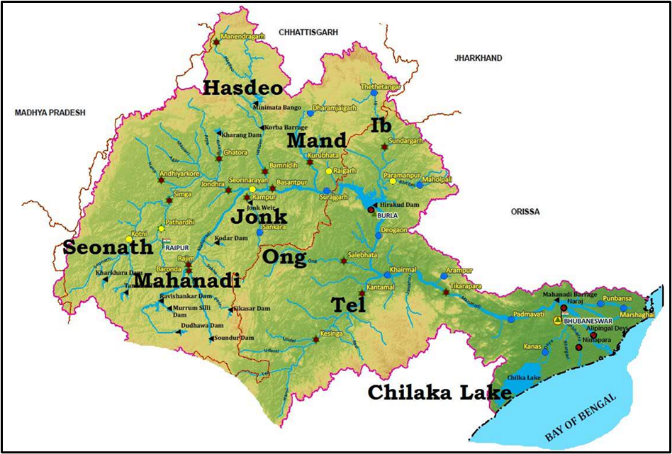
- Origin: Northern foothills of Dandakaranya, in Raipur district (Chhattisgarh) at an elevation of 442 meters.
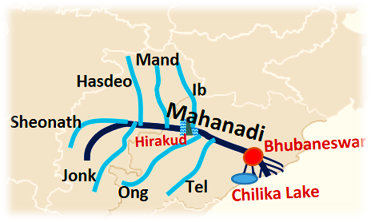
- After collecting tributaries like Seonath, it turns eastward, entering Odisha.
- Key Landmarks:
- Sambalpur – Site of the Hirakud Dam
- Cuttack – Gateway to Odisha plains
- False Point – Where it drains into the Bay of Bengal
🛤️ By the end, it fans out through multiple channels into the sea, forming a deltaic region, much like Ganga or Godavari.
🌊 Hirakud Dam
Located near Sambalpur, the Hirakud Dam is one of India’s largest multipurpose river valley projects.
- It forms a man-made lake ~55 km long.
- Functions:
- Irrigation
- Flood Control
- Hydropower
- Water Supply
It’s not just a dam—it’s a civilizational intervention, managing both the benevolence and wrath of the Mahanadi.
🌾 Agricultural and Silt Deposition
- Major Land Use: Agriculture
- Known as one of the most active silt-depositing rivers in India.
💡 This means it brings nutrient-rich alluvium, especially in the delta, making it fertile—ideal for paddy cultivation and other crops.
🌊 Tributaries of Mahanadi
Left-bank Tributaries (joining from the north):
- Seonath
- Hasdeo
- Mand
- Ib
Right-bank Tributaries (joining from the south):
- Ong
- Tel
- Jonk
🧠 Left and Right banks are decided facing downstream
🛠️ Projects on the Mahanadi
🏗️ Pre-Plan Era:
- Mahanadi Main Canal
- Tandula Reservoir (Chhattisgarh)
🏗️ Post-Planning Period:
- Hirakud Dam
- Mahanadi Delta Project
- Hasdeo Bango
- Mahanadi Reservoir Project
These projects show how the state used geography to serve development—an example of human-river symbiosis.
🏙️ Industry and Urbanization
- Urban Centres: Raipur, Durg, Cuttack
- Industries:
- Iron & Steel Plant – Bhilai
- Aluminium – Hirakud, Korba
- Sugar & Textile Mills
- Coal, Iron, Manganese Mining
🧠 Mahanadi Basin has a rich mineral base + water + energy—a perfect cocktail for industrialization.
🌊 Floods – A Recurring Challenge
- Deltaic region of Odisha is flood-prone.
- Causes:
- Low channel capacity in lower course.
- Heavy rainfall in short bursts.
⛲ Flood Control Measures:
- Hirakud Dam stores floodwater and offers partial relief.
- But due to sediment load and intense monsoons, floods persist.
🧠 The river that feeds also has the power to destroy—a duality often seen in natural systems.
📌 In Summary: Why Study the Mahanadi?
Because it’s a microcosm of:
- Hydrology (origin, tributaries, delta)
- Agriculture (alluvial plains, silt)
- Industry (urban growth, mineral resources)
- Disaster Management (floods)
- Human-Environment Relationship (dams, irrigation)
🌊 The Godavari River – The ‘Dakshin Ganga’ of India
🕉️ The Godavari is not just a river. It’s a symbol of sanctity and sustenance, earning the title of Dakshin Ganga—the Ganga of the South.
📏 Length: 1,465 km
🌍 Drainage Area: ~3 lakh sq. km—making it the largest river system of Peninsular India
Just like the Ganga nurtures the Indo-Gangetic plains in the north, Godavari breathes life into central and southern India.
📍 Origin and Course
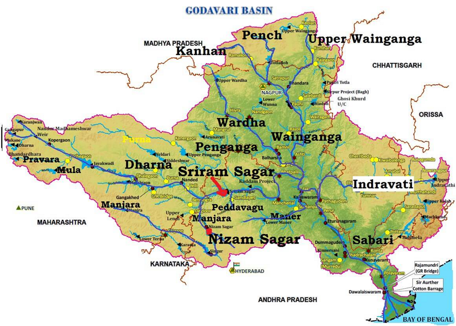
- Origin: Trimbakeshwar, in the Nashik district of Maharashtra
(Godavari → Also called Lifeline of Maharashtra) - Elevation: 1,067 m
- Distance from Arabian Sea: ~80 km (Yes, it begins just near the west coast but flows all the way east!)
🧭 Direction: Despite originating near the Arabian Sea, it takes a U-turn journey to the Bay of Bengal.
➡️ Moral of Geography: Rivers don’t always flow to the nearest sea. They obey elevation and geological gradients, not human logic.
🗺️ Geographical Spread
The Godavari basin spans:
- Major states: Maharashtra, Telangana, Andhra Pradesh, Chhattisgarh, Odisha
- Others: Madhya Pradesh, Karnataka, and even a small portion of Puducherry (Yanam)
It’s bounded by:
- North: Satmala Hills, Ajanta Range, Mahadeo Hills
- South & East: Eastern Ghats
- West: Western Ghats
🧠 Think of this as a natural bowl, where Godavari acts like the central stream, collecting water and sediments from all sides.
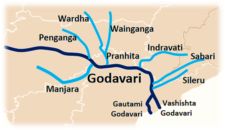
🧩 Tributaries
📌 Key Insight: Left-bank tributaries are more numerous and larger.
🔹 Left Bank:
- Pench, Wainganga, Wardha, Penganga, Pranahita, Indravati, Sabari
(Pranahita itself is a massive sub-basin collecting water from Penganga, Wardha, Wainganga)
🔹 Right Bank:
- Manjra (most prominent – 724 km), Pravara, Mula, Maner, Peddavagu
🧠 The tributaries reflect the asymmetrical structure of the basin—left side is more extensive, collecting water from central India’s wetter plateau.
🌊 The Delta – Gateway to the Sea
- Near Rajahmundry, Godavari splits into:
- Gautami Godavari (east)
- Vashishta Godavari (west)
- It forms a lobate delta—like a bulging fan, with multiple distributaries.
🌾 This delta is fertile and agriculturally productive, but also vulnerable to cyclones, floods, and drainage congestion.
🪨 Mineral Resources
The basin is geologically diverse, creating a rich resource base:
Upper Reaches:
- Deccan Traps: rich in minerals like magnetite, zircon, biotite
Middle Basin:
- Rocks like phyllites, quartzites, granites dominate
Gondwana Rocks (downstream middle basin):
- Contain detrital matter + thick coal seams
- E.g. Singareni Coalfields (Telangana)
Lower Basin:
- Dominated by Khondalite rocks of the Eastern Ghats
🧠 This diversity has allowed coal mining, metallurgy, and power production—a rare mix of agriculture and mineral-based economy.
🏗️ River Valley Projects
Like most major rivers, Godavari has been harnessed for development.
✅ Completed Projects:
- Sriram Sagar
- Godavari Barrage
- Upper Penganga
- Jaikwadi
- Upper Wainganga
- Upper Indravati
- Upper Wardha
🏗️ Ongoing Projects:
- Pranahita–Chevella
- Polavaram Project (mega dam project with major inter-state implications)
🧠 These are multi-purpose projects—for irrigation, hydroelectricity, flood control, and inter-basin water transfer.
🏙️ Urbanization and Industry
Major Cities:
- Nagpur, Aurangabad, Nashik, Rajahmundry
Key Industries:
- Automobile: Nashik, Aurangabad
- Agro-based: rice mills, cotton spinning, sugar, oil pressing
- Others: cement, small engineering units
🧠 The basin supports both modern industrial zones and traditional rural industries, making it a mixed-development zone.
⚠️ Floods and Droughts
🌊 Floods:
- Lower basin faces annual floods
- Cyclones from Bay of Bengal worsen the damage
- Delta experiences drainage congestion due to flat land
🌵 Droughts:
- Marathwada region (Maharashtra) is chronically drought-prone
- Causes:
- Rain-shadow zone
- Poor irrigation infrastructure
🧠 This dual reality—floods in the east, droughts in the west—shows the inequality of water distribution, even within a single basin.
📌 Summary – Why Godavari Matters
The Godavari is:
- A river of extremes – rain-rich east vs drought-prone west
- A symbol of reverence – Dakshin Ganga
- A powerful economic artery – minerals, industries, agriculture
- A hydrological marvel – long course, massive tributaries, vast delta
- A development case study – interlinking rivers, dams, floods, droughts
🌊 The Krishna River – The Artery of Southern Deccan
- The Krishna is the second-largest east-flowing river of Peninsular India (after Godavari).
- It is revered not just for its water but also for the civilizations it has nourished.
📏 Length: 1,400 km
🌍 Basin Area: ~2.6 lakh sq. km
It doesn’t just flow—it connects Maharashtra, Karnataka, Telangana, and Andhra Pradesh, weaving them into a hydrological and cultural fabric.
📍 Origin and Course
- Origin: From Jor village near Mahabaleshwar (Satara district, Maharashtra)
- Altitude: 1,337 m (Western Ghats)
🧭 Course: From the Western Ghats to the Bay of Bengal, crossing the Deccan plateau, forming valleys, and finally building a broad delta.
🧠 The Krishna, like Godavari, shows how the Peninsular rivers carve eastward paths, despite rising close to the west coast.
🗺️ Krishna Basin – The Catchment Canvas
- States Covered: Maharashtra, Karnataka, Telangana, Andhra Pradesh
- Boundaries:
- North: Balaghat range
- South & East: Eastern Ghats
- West: Western Ghats
⛰️ A textbook example of a plateau basin surrounded by hills—water flowing down from all directions into Krishna’s main channel.
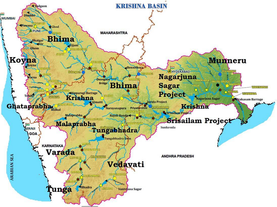
🌾 Delta – Where Krishna Meets the Sea
- The Krishna Delta has a shoreline of ~120 km.
- It appears to merge with the Godavari Delta, forming a combined deltaic region stretching 35 km into the sea.
🧠 This delta confluence is agriculturally rich, but hydrologically fragile—prone to floods and cyclones.
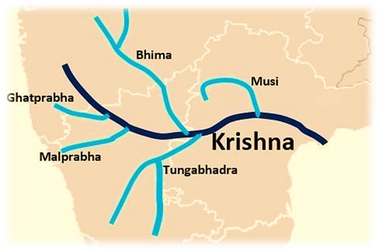
🧩 Tributaries – The Lifelines of Krishna
Like veins feeding the heart, tributaries pour their waters into Krishna from both banks.
🔹 Right Bank Tributaries:
- Ghatprabha
- Malprabha
- Tungabhadra (most significant)
🔸 Left Bank Tributaries:
- Bhima
- Musi (flows through Hyderabad)
- Munneru
✅ Key Details:
- Tungabhadra is formed by the Tunga and Bhadra rivers at Gangamula (Central Sahyadri).
- Bhima starts from Matheron Hills, joins Krishna near Raichur.
- Koyna, though small, is geologically significant—its dam (Koyna Dam) likely triggered the 1967 earthquake (6.4 Richter, 150 lives lost).
🧠 Tributaries reflect diversity in terrain—western ghats (steep), Deccan plateau (gentle), and urbanized plains (Musi at Hyderabad).
🏗️ Projects – Harnessing the River’s Power
✅ Major Dams/Projects:
- Tungabhadra Project (interstate)
- Nagarjuna Sagar
- Srisailam
- Almatti, Bhima, Ghataprabha, Malaprabha, Telugu Ganga
⚡ Hydropower Stations:
- Koyna, Tungabhadra, Srisailam, Nagarjuna Sagar, Almatti, Narayanpur, Bhadra
🧠 These projects are not just about electricity. They serve irrigation, urban water supply, flood control, and inter-basin transfers—e.g., Telugu Ganga aims to provide water to Chennai.
🪨 Resources – Nature’s Wealth
- The Krishna Basin is mineral-rich, with resources supporting:
- Mining
- Natural gas exploration
- Industrial development
💎 The Krishna-Godavari (K-G) Basin is especially important:
- In 2003, Reliance Industries struck India’s biggest natural gas reserves in KG D-6 block (offshore).
🧠 This discovery changed India’s energy landscape, linking hydrology and economy.
🏙️ Urban and Industrial Development
🏙️ Major Cities:
- Hyderabad (Telangana capital, IT hub)
- Pune (Automobiles, IT, education center)
✅ These cities utilize Krishna’s water through urban water supply systems, enabling the tech and industrial boom in the region.
⚠️ Floods and Droughts
🌵 Drought-Prone Areas:
- Parts of Karnataka and Maharashtra, due to:
- Rain-shadow effect
- High evapotranspiration
- Overuse of groundwater
🌊 Flood-Prone Areas:
- Delta regions, especially Andhra Pradesh
⚠️ Key Concern:
- Silt deposition raises the river bed in the delta.
- During cyclonic rainfall, the reduced carrying capacity leads to frequent floods.
🧠 The basin faces a dual challenge—floods in one part, drought in another—demanding adaptive water management.
📌 Summary – Why Krishna River Matters
The Krishna River is:
- A crucial east-flowing artery of the peninsula
- A source of water, energy, agriculture, and industry
- A mineral-rich, energy-yielding basin (KG D-6)
- A delta-forming, civilization-supporting river
- A classic case of hydrological asymmetry—floods and droughts coexist
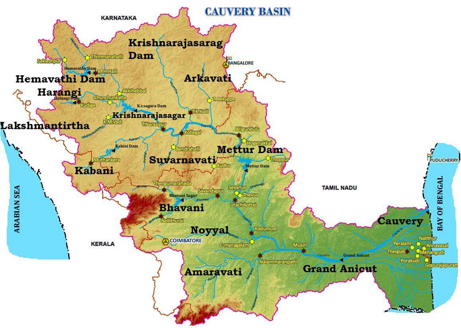
🕉️ Kaveri River
- The Kaveri, also spelled Cauvery, is often called Dakshin Ganga, or the Ganga of the South.
- While Godavari is more frequently honored with this title due to its length and size, Kaveri earns it for its spiritual and cultural prominence, especially in Tamil Nadu and southern Karnataka.
📏 Length: ~800 km
🌍 Basin Area: ~81,000 sq. km
📍 States Covered: Karnataka, Tamil Nadu, Kerala, and Puducherry (UT)
🗻 Origin and Course
- Origin: Talakaveri in the Brahmagiri Hills, Kodagu (Coorg) district, Karnataka
- Elevation: 1,341 m (Western Ghats)
- Flows eastward, descends through Shivanasamudram falls, enters Tamil Nadu, and finally forms the Cauvery Delta before entering the Bay of Bengal.
🏞️ Physiography of the Basin
- Bounded by:
- West – Western Ghats
- East/South – Eastern Ghats
- North – Watersheds separating it from Krishna and Pennar basins
🔍 Physiographic Zones:
- Western Ghats (origin point)
- Mysore Plateau
- Delta region (most fertile)
🧠 The Nilgiris form a crucial bridge between Western and Eastern Ghats, dividing the basin into:
- Northern region: Karnataka Plateau
- Southern region: Tamil Nadu Plateau
🌧️ Rainfall and Flow Pattern
- Upper basin (Karnataka): Receives rain from South-West Monsoon
- Lower basin (Tamil Nadu): Receives rain from North-East Monsoon
💧 This dual-monsoon supply ensures that Kaveri is nearly perennial and highly regulated, ideal for:
- Irrigation
- Hydropower generation
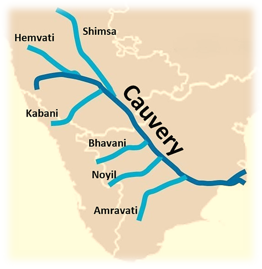
🌊 Tributaries of the Kaveri River
🔹 Left Bank Tributaries:
- Harangi
- Hemavati
- Shimsha
- Arkavati
🔸 Right Bank Tributaries:
- Lakshmantirtha
- Kabini
- Suvarnavati
- Bhavani
- Noyil
- Amaravati
✅ These tributaries flow down the Western Ghats and Plateaus, feeding Kaveri and helping form waterfalls, reservoirs, and deltas.
🏞️ Notable Features Along the Course
- Shivanasamudram Falls: River splits into two, descends 101 m → early hydroelectric project (Asia’s first, 1902)
- Mekedatu (Goat’s Leap): The two branches reunite and flow through a deep gorge
- Hogenakkal Falls: Scenic fall before the river enters Mettur Reservoir
- Mettur Dam: Regulates flow and supports irrigation
- Akhanda Cauvery: Widened section of the river after Mettur
- Grand Anicut (Kallanai): One of the oldest water diversion structures (1st Century CE, Chola dynasty)
- Delta formation: River splits into Coleron (North branch) and Kaveri (South), enclosing Srirangam Island
🧱 Projects on the Kaveri River
📌 Pre-Plan Era Projects:
- Krishnarajasagar Dam (Karnataka)
- Mettur Dam
- Cauvery Delta system
📌 Post-Plan Projects:
- Hemavati
- Kabini
- Harangi
- Lower Bhavani
💡 These projects collectively make Kaveri one of the best-utilized rivers in India, with most of its potential already tapped.
🏭 Industrial Development in Kaveri Basin
- Bangalore: Just outside the basin but indirectly supported by its waters
- Coimbatore & Mysore:
- Cotton textile industries
- Cement factories
- Engineering and steel industries (e.g., Salem Steel Plant)
- IT, education, and manufacturing hubs
🧠 Industries thrive due to water security, fertile plains, and connectivity—a classic river-industrial relationship.
🌱 Soils in the Basin
- Red soils: Most common (in Karnataka plateau)
- Alluvial soils: Found in the delta
- Laterites, black soils, forest and mixed soils also found
🧠 This soil diversity, coupled with perennial water, makes Kaveri delta one of the most productive regions in South India.
🌊 Floods and Hydrology
- Shape:
- Fan-shaped in Karnataka
- Leaf-shaped in Tamil Nadu
✅ This unique shape slows down runoff, meaning:
- No sudden floods
- Relatively gentle and predictable hydrology
This also helps effective water management and irrigation planning.
🌊 Pennar River
- The Pennar River, also called Uttara Pinakini, is one of the major east-flowing rivers of peninsular India, though much smaller in size and economic impact compared to rivers like the Godavari or Kaveri.
- It plays an important local role in southern Andhra Pradesh and southeastern Karnataka.
📏 Length: ~597 km
🌍 Basin Area: Covers Andhra Pradesh and Karnataka
🗻 Origin and Course
- 🏞️ Origin: Chenna Kesava Hill, part of the Nandidurg Range, Chikkaballapura district, Karnataka
- 🧭 Flow Direction: Eastward into Andhra Pradesh, eventually draining into the Bay of Bengal near Nellore.
💡 It flows through rain-shadow regions, which explains its seasonal nature and lower discharge.
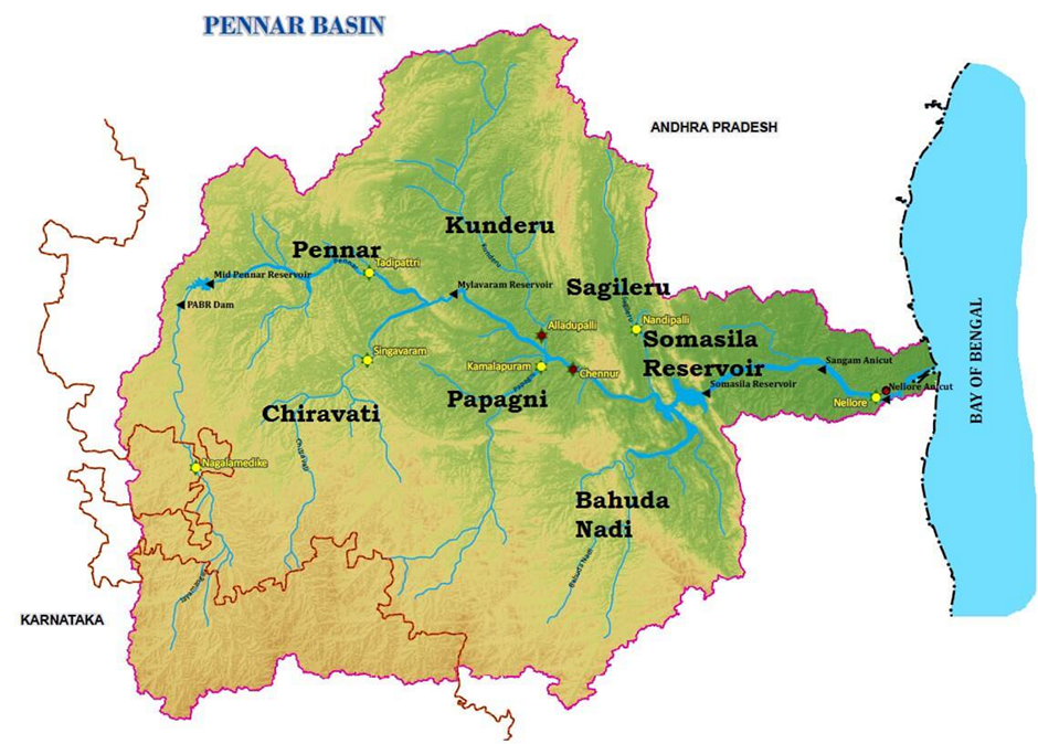
🏞️ Physiographic Features
🗺️ The fan-shaped Pennar basin is bordered by:
| Direction | Natural Boundary |
| North | Erramala Hills |
| East | Nallamala & Velikonda Ranges (Eastern Ghats) |
| South | Nandidurg Hills |
| West | Ridge separating it from Vedavati Valley (Krishna Basin) |
🔻 Other notable ranges south of the river:
- Seshachalam Hills – famous for Red Sanders wood
- Paliconda Range
🌊 Tributaries of the Pennar River
🔹 Left Bank:
- Jayamangali
- Kunderu
- Sagileru
🔸 Right Bank:
- Chiravati
- Papagni
- Cheyyeru
🧠 Many of these tributaries are seasonal, fed by monsoon rains, which limits the perennial utility of the river.
🛠️ Projects on the Pennar River
💧 Water Management Projects:
- Tungabhadra High-Level Canal (from Krishna Basin): Irrigates part of the Pennar Basin.
- Somasila Project: The only major water storage and irrigation project directly on the Pennar River.
🧠 These interventions are limited due to:
- Low rainfall
- Seasonal flow
- Limited elevation gradient
🏭 Industry and Urbanization
- 🏙️ The only major urban center in the Pennar Basin is Nellore (Andhra Pradesh), located near the river’s mouth.
- Industrial development is minimal, due to:
- Low water availability
- Limited mineral resources
- Scanty and seasonal rainfall
💡 This is why Pennar is not heavily dammed or industrially utilized like the Godavari or Kaveri.
⚠️ Challenges and Constraints
- Rain-shadow area: Lies on the eastern leeward side of the Western Ghats, receiving low rainfall.
- Water scarcity during non-monsoon months.
- Agricultural limitations in unirrigated areas.
- No major industries or economic hubs apart from Nellore.
🌊 Other East-Flowing Rivers of Peninsular India
While rivers like the Godavari, Krishna, and Cauvery dominate peninsular river systems, several medium and minor rivers also flow eastward into the Bay of Bengal. These rivers may be smaller, but they hold regional significance in terms of irrigation, ecology, and water availability.
🪙 Subarnarekha River
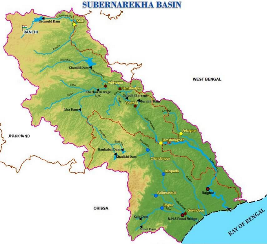
Subarnarekha literally means “Streak of Gold” — because traces of gold were once found in its sands.
- 🏞️ Origin: Ranchi Plateau, Jharkhand
- 🌊 Length: ~395 km
- 🗺️ Flows through: Jharkhand → West Bengal → Odisha
- 🧭 Joins: Bay of Bengal (forming an estuary between Ganga and Mahanadi deltas)
🧠 Special Point: It forms part of the state boundary between West Bengal and Odisha in the lower course.
🛕 Brahmani River – The Second Most Important River of Odisha
- 🏞️ Formation: By the confluence of Koel and Sankh rivers near Rourkela (Odisha)
- 🌊 Length: ~800 km
- 🗺️ Flows through: Jharkhand, Chhattisgarh, Odisha
- 🧭 Drains into: Bay of Bengal
🧠 Basin Boundaries:
- North: Chhotanagpur Plateau
- West & South: Mahanadi basin
- East: Bay of Bengal
💡 It is the second largest river of Odisha after the Mahanadi and flows roughly parallel to Mahanadi.
🌴 Sarada River – Local Lifeline of Visakhapatnam
- 🗺️ Flows in Visakhapatnam district, Andhra Pradesh
- ⚖️ Medium-sized, east-flowing river
- 🌊 Joins the Bay of Bengal
🧠 Sarada is important for irrigation in north coastal Andhra Pradesh but is not a perennial river.
🪨Ponnaiyar River – Eastern Ghats-Shadowed Stream
- 📍 Flows through Tamil Nadu, Karnataka, and a bit of Andhra Pradesh
- 🧭 East-flowing, drains into Bay of Bengal
- 📐 Small basin, confined to coastal and inland areas
🧠 Basin Bounded By Eastern Ghats Ranges:
- North-West & South: Velikonda, Nagari, Javadu, Shevaroy, Chitteri, and Kalrayan Hills
- East: Bay of Bengal
🔎 The Ponnaiyar is seasonal, dependent on northeast monsoon rains, often resulting in flooding during heavy rains in Tamil Nadu.
🌿 Vaigai River – Lifeline of Madurai
- 🌊 Longest river south of Cauvery delta
- 🗺️ Flows in Tamil Nadu
- 🧭 Drains into Palk Strait and Palk Bay
🧠 Basin Boundaries:
- West: Varushanadu, Andipatti, Cardamom, and Palani Hills
- East: Palk Strait/Bay
🏙️ Madurai city lies on its banks — Vaigai is the soul of this ancient city.
💡 Final Insight
These rivers might not be as famous or mighty as the Godavari or Kaveri, but they play a critical role in local agriculture, water supply, and ecological balance. For UPSC, these are often asked in match-the-following, tributary-origin questions, and river-basin mapping.