
Classification of Air Masses
Now that we know where air masses form, the next step is to understand how scientists classify them.
Classification is important because different types of air masses bring different types of weather — and UPSC often asks questions that hinge on identifying these relationships.
Basis of Classification
When classifying air masses, meteorologists consider:
- Weather conditions at the source region (temperature, humidity, lapse rate).
- Changes in these properties as the air mass travels away from its source.
So, classification is not just about where it was born — it’s also about what happens to it during its journey.
Two Main Approaches
- Geographical Classification → Based on where the air mass originates.
- Thermodynamic Classification → Based on temperature relationship between the air mass and the surface it moves over.
Geographical Classification
Broad Categories – Based on Latitude of Source Region
Trewartha’s widely used scheme divides air masses into two broad latitude-based groups:
- Polar Air Mass (P) → Originates in polar or arctic areas.
- Tropical Air Mass (T) → Originates in tropical or equatorial areas.
Further Division – Based on Nature of Surface
Each of the above categories is further split based on the type of surface at the source region:
- Continental (c) → Formed over land; generally dry.
- Maritime (m) → Formed over oceans; generally moist.
💡 Key Point:
- A continental air mass can change into a maritime type if it passes over the ocean (by picking up moisture).
- But a maritime air mass rarely becomes a true continental type when it moves over land — because moisture loss is slower than moisture gain.
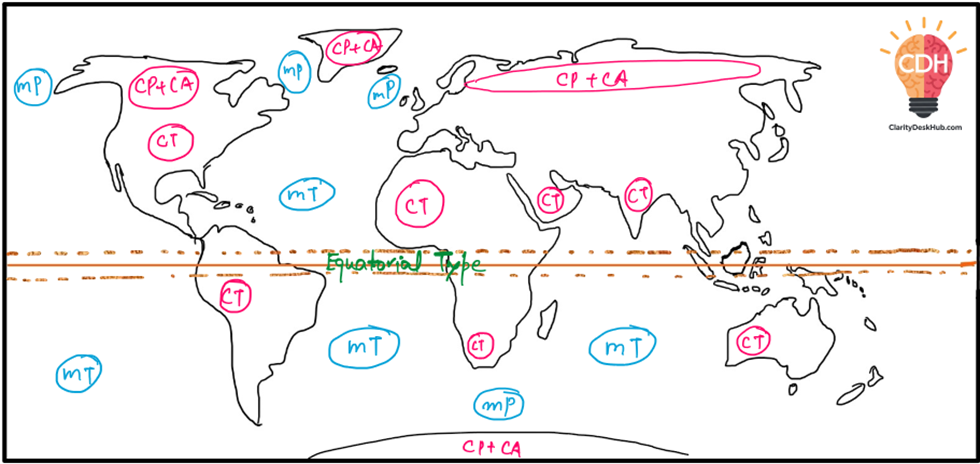
The Four Principal Types (Geographical)
Combining latitude and surface type, we get four main geographical categories:
1. Continental Polar (cP)
📍 Source Region: Arctic Basin, Northern North America, Eurasia, and Antarctica.
❄️ Characteristics: Dry, cold, and stable.
Picture yourself in Siberia during winter. The land is frozen, the sky is crystal clear, and the air feels like it has been locked in an icebox for centuries. This is the realm of Continental Polar (cP) air masses—cold, dry, and motionless, keeping everything beneath them frozen solid.
In Winter:
- Frigid conditions dominate.
- Skies remain clear, with little moisture to form clouds.
- Winds are light, as cold, dense air settles like a giant ice sheet over the land.
In Summer:
- The sun’s heat warms the land slightly, reducing snowfall.
- Winds become more variable, though the air mass retains its dryness.
Impact on Weather: When these air masses move southward, they bring sudden cold waves and dry spells, making them responsible for some of the harshest winters in places like Canada, Russia, and the northern United States.
2. Maritime Polar (mP)
📍 Source Region: Oceans between 40° and 60° latitude.
🌧 Characteristics: Cool, moist, and unstable.
Imagine you’re on a ship sailing across the North Atlantic. The air is damp, the waves are rough, and sudden showers drench the deck. This is the world of Maritime Polar (mP) air masses—cold but loaded with moisture from the ocean.
In Winter:
- High humidity leads to cloudy skies.
- Frequent precipitation, from drizzle to heavy snow.
- Stormy weather, especially near coastlines.
In Summer:
- The air stabilizes, leading to clear and fair weather.
Impact on Weather: These air masses often clash with warmer air from the tropics, leading to cyclonic storms over Europe and North America’s east and west coasts.
3. Continental Tropical (cT)
📍 Source Region: The Sahara Desert, West Asia, and Australia.
🔥 Characteristics: Hot, dry, and stable.
Picture yourself in the middle of the Sahara at noon. The sun blazes overhead, the sand burns beneath your feet, and there’s not a drop of moisture in the air. This is the realm of Continental Tropical (cT) air masses, which dominate the world’s deserts.
In Winter:
- The air remains dry and warm, with little seasonal change.
In Summer:
- Temperatures soar to extreme levels.
- The heat intensifies droughts and wildfires.
Impact on Weather: When these air masses move, they bring heat waves, drying out farmlands and fueling forest fires in regions like the Middle East, North Africa, and Australia.
4. Maritime Tropical (mT)
📍 Source Region: The Gulf of Mexico, the Pacific, and the Atlantic Oceans.
🌊 Characteristics: Warm, humid, and unstable.
Now, let’s shift to the tropical ocean. The air is heavy with moisture, the sky is filled with fluffy cumulus clouds, and you can feel the stickiness of high humidity. Welcome to the Maritime Tropical (mT) air mass—the fuel behind the world’s heaviest rains.
In Winter:
- Mild temperatures with overcast skies and fog.
In Summer:
- High humidity creates towering clouds.
- Heavy convectional rainfall leads to tropical storms and hurricanes.
Impact on Weather: These air masses are responsible for monsoons, hurricanes, and the muggy summer heat in places like India, the southeastern US, and Southeast Asia.
Comparison Table
| Continental Polar | Maritime Polar | Continental Tropical | Maritime Tropical | |
| Source Regions | Arctic basin, Northern North America, Eurasia and Antarctica | Oceans between 40o and 60o latitude | tropical and sub-tropical desert of Sahara in Africa and of West Asia and Australia. | oceans in tropics and sub-tropics such as Mexican gulf, the pacific and the Atlantic Ocean. |
| Characteristics | dry, cold and stable conditions | cool, moist and unstable. | dry, hot and stable and do not extend beyond the source | warm, humid and unstable |
| During Winter | frigid, clear and stable | high humidity, overcast skies and occasional fall of precipitation | dry throughout the year | high temperatures, overcast skies and fog. |
| During Summer | stable with lesser prevalence of anti-cyclonic winds, warmer land masses and less snow | clear, fair and stable | dry throughout the year | high temperature, high humidity, cumulous clouds and convectional rainfall. |
Final Thoughts
These four air masses constantly battle for dominance, shaping the world’s weather. When they meet, dramatic weather changes occur—like when warm Maritime Tropical air meets cold Continental Polar air, triggering violent storms.
Thermodynamic Modifications and Classification of Air Masses
Up to this point, we’ve seen how air masses are classified based on where they are born — their geographical classification.
But there is another equally important way to classify them — based not on their birthplace, but on what happens to them after they leave home.
This is the thermodynamic classification — which focuses on how an air mass’s temperature, moisture, and stability change as it travels over new surfaces.
What is Thermodynamic Modification?
When an air mass moves away from its source region:
- It interacts with new surfaces — land or water that may be warmer or cooler than itself.
- This leads to heating or cooling from below, changes in stability, and sometimes moisture gain through evaporation or precipitation.
Simply put: The journey changes the traveller — and in meteorology, this journey changes the weather-making ability of the air mass.
Key Factors that Control Modification
The degree of modification depends on:
- Initial characteristics → Temperature and moisture at the time of origin.
- Nature of new surface → Land vs water; cold vs warm.
- Path of travel → Over deserts, oceans, forests, or ice fields.
- Travel time → Longer travel = more modification.
Heating from Below – Leads to Instability
If an air mass moves over a surface warmer than itself:
- The lower layers of the air mass get heated.
- Lapse rate steepens (temperature drops faster with height).
- Warm air rises → instability increases.
- If moisture is present → condensation, cloud formation, and precipitation can occur.
Example: Cold polar air moving over warmer mid-latitude oceans.
Cooling from Below – Leads to Stability
If an air mass moves over a surface colder than itself:
- The lower layers of the air mass get cooled.
- Air becomes stable — vertical movement is suppressed.
- Cloud formation and precipitation are unlikely → dry, settled weather.
Example: Warm tropical air moving over cold land or water surfaces.
Warm vs Cold Air Mass (Thermodynamic Sense)
Here, warm or cold doesn’t mean absolute temperature — it means temperature relative to the underlying surface:
- Warm air mass (w) → Air mass is warmer than the surface below.
- Cold air mass (k) → Air mass is colder than the surface below.
Stability vs Instability
- Stable air mass → Descending air dominates; weather is generally calm and dry.
- Unstable air mass → Upward air movement dominates; can lead to cloud formation and precipitation.
Mechanical (Dynamic) Modifications
Besides heating and cooling, mechanical processes also modify air masses:
- Turbulent mixing → Due to eddies or convection.
- Divergence & convergence → Affect lapse rate and cloud formation.
- Subsidence & lateral spreading → Common in anticyclones; promotes stability.
- Lifting & convergence at surface → Common in cyclones; promotes instability.
- Advection → Horizontal transport of air properties from one region to another.
Thermodynamic Classification
Based on these modifications, we have:
A. Cold Air Mass (k)
- Colder than the surface it moves over.
- Usually unstable (heated from below).
B. Warm Air Mass (w)
- Warmer than the surface it moves over.
- Usually stable (cooled from below).
Each of these is further divided into:
- Stable air mass
- Unstable air mass
So, the thermodynamic classification is like a “travel diary” of the air mass — it records how its character changes on the road, and whether it will bring calm sunshine or turbulent rainfall when it arrives at its destination.
Cold and Warm Air Masses
Now, we have already understood how air masses are classified — first by geography, then by thermodynamics.
Now let’s zoom in on the two core thermodynamic categories — cold air masses and warm air masses — and see how they behave, both in their home regions and when they travel elsewhere.
(i) Cold Air Masses
Origin: Polar and Arctic regions.
Properties in Source Region
- Very low temperature → Due to intense heat loss via outgoing longwave terrestrial radiation.
- Extremely low specific humidity → Cold air can hold very little moisture.
- High stability → Weak vertical movement; normal lapse rate is low.
Properties After Leaving Source Region
- Temperature drops in the areas they reach.
- Warmed from below if the surface is warmer → increases lapse rate → air becomes unstable → convective currents form.
- Over warm ocean → humidity rises, cumulonimbus clouds develop.
- Visibility generally remains clear.
- Precipitation only if over warm ocean; over warm land → mostly clear skies.
- If partly over warm ocean and partly over cold land → cyclonic conditions may develop.
Subtypes:
- Continental Cold Air Mass (cK) — Dry, cold.
- Maritime Cold Air Mass (mK) — Moist, cold.
(ii) Warm Air Masses
Definition: Temperature greater than the surface temperature of the region visited.
Formation and Behaviour
- Origin: Subtropical regions with anticyclonic conditions.
- Cooled from below → lower layers become stable → vertical movement suppressed.
- Weather tends to be settled and dry (unless extra moisture or lifting mechanism is present).
Subtypes:
- Continental Warm Air Mass (cW) — Dry, warm.
- Maritime Warm Air Mass (mW) — Moist, warm.
Full Thermodynamic + Mechanical Classification
When we combine:
- Source region (continental/maritime)
- Latitude (polar/tropical)
- Relative temperature (cold/warm)
- Stability (stable/unstable)
…we get 16 distinct types of air masses.
| S. No. | Type | Symbol | Key Features |
| 1 | Continental Polar Cold Stable | cPKs | Very cold, dry, stable. |
| 2 | Continental Polar Cold Unstable | cPKu | Very cold, dry, unstable (heated from below). |
| 3 | Continental Polar Warm Stable | cPWs | Cold origin, warmed relative to surface, stable. |
| 4 | Continental Polar Warm Unstable | cPWu | Cold origin, warm relative to surface, unstable. |
| 5 | Maritime Polar Cold Stable | mPKs | Cold, moist, stable. |
| 6 | Maritime Polar Cold Unstable | mPKu | Cold, moist, unstable (often cloudy). |
| 7 | Maritime Polar Warm Stable | mPWs | Polar origin, warm relative to surface, stable. |
| 8 | Maritime Polar Warm Unstable | mPWu | Polar origin, warm relative to surface, unstable. |
| 9 | Continental Tropical Cold Stable | cTKs | Hot origin, cooled relative to surface, stable. |
| 10 | Continental Tropical Cold Unstable | cTKu | Hot origin, cooled relative to surface, unstable. |
| 11 | Continental Tropical Warm Stable | cTWs | Hot, dry, stable. |
| 12 | Continental Tropical Warm Unstable | cTWu | Hot, dry, unstable. |
| 13 | Maritime Tropical Cold Stable | mTKs | Warm, moist origin; cooled relative to surface, stable. |
| 14 | Maritime Tropical Cold Unstable | mTKu | Warm, moist origin; cooled relative to surface, unstable. |
| 15 | Maritime Tropical Warm Stable | mTWs | Warm, moist, stable. |
| 16 | Maritime Tropical Warm Unstable | mTWu | Warm, moist, unstable; high rainfall potential. |
Symbol Code:
- c = Continental
- m = Maritime
- P = Polar
- T = Tropical
- K = Cold (relative to surface)
- W = Warm (relative to surface)
- s = Stable
- u = Unstable
✅In summary:
This detailed thermodynamic + mechanical classification is like the complete identity card of an air mass — telling us not just where it came from, but also how it behaves when it interacts with different surfaces and weather systems. For UPSC, remembering the logic behind each symbol (rather than rote memorising all 16 types) will make this section easier to recall in exams.