
Cloudburst: A Natural Hazard
Let’s begin with the definition.
A cloudburst is an extremely intense rainfall event occurring over a localized area (20–30 sq km) at a very high rate (≥10 cm/hour).
It is one of the most devastating short-duration weather phenomena and often leads to flash floods and landslides.
In simple terms, it’s like the cloud suddenly “bursting open” — releasing enormous rain in a very short time.
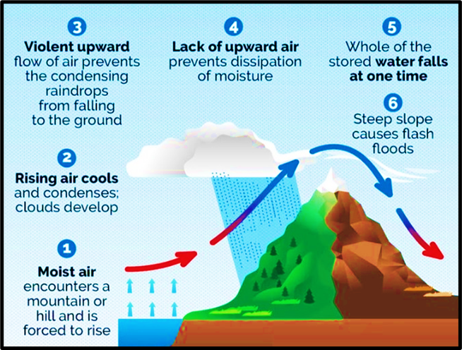
⚙️ Formation of a Cloudburst – The Science Behind It
The mechanism is simple but dramatic.
1. Saturated clouds (full of moisture) hover over a region.
2. Strong upward air currents (convection) prevent the raindrops from falling — they keep pushing them upwards.
3. The cloud keeps forming new droplets while existing ones grow larger.
4. Eventually, the droplets become too heavy for the cloud to hold →
All of them fall together suddenly = Cloudburst.
💡 In mountain regions, steep slopes and heated air currents help lift moist air rapidly, which increases the chances of cloudbursts.
🌦️ When and Where Do They Occur in India?
Cloudbursts are most common during the monsoon season, especially in mountainous and orographically influenced regions, where moist monsoon winds are forced to rise abruptly.
📍 Vulnerable Regions:
- Himalayas (Uttarakhand, Himachal Pradesh, J&K, Sikkim)
- North-Eastern States
- Western Ghats (Kerala, Karnataka, Maharashtra)
- Rarely, even plains may experience it (e.g., Hyderabad 1908, Mumbai 2005).
📚 Typical Meteorological Situation
- Monsoon clouds move northward from the Bay of Bengal → cross Ganga plains → hit the Himalayas.
- Orographic uplift + low-pressure systems cause sudden condensation and rain.
- Sometimes, multiple cloudburst events occur in one episode —
💡 Example: Uttarakhand 2013 had two major cloudbursts.
🇮🇳 Major Cloudburst Events in India (Historical Examples)
| Event | Location & Year | Impact |
|---|---|---|
| Great Musi Flood | Hyderabad, 1908 | 15,000+ deaths, urban deluge |
| Mumbai Cloudburst | 2005 | 944 mm in 24 hrs — record rainfall, 500+ deaths |
| J&K Cloudburst | 2010 | Leh region – massive flash floods |
| Uttarakhand Cloudbursts | 1998 & 2013 | Triggered Kedarnath disaster, multiple landslides |
| Chennai Floods | 2015 | Though not classic cloudburst, local intense convection caused urban flooding |
Recent Cloudburst Incidents in India(2025)
| Date | Location | Details / Impact |
|---|---|---|
| August 5, 2025 | Uttarakhand (Dharali village, over Kheer Ganga River) | Cloudburst caused sudden flash floods in Dharali village, leading to extensive damage and casualties. |
| August 9, 2025 | Kullu, Himachal Pradesh (Sharod Nala area) | Intense cloudburst raised the water levels of Barogi Nala, causing local flooding and infrastructure damage. |
| August 14, 2025 | Kishtwar, Jammu & Kashmir (Chashoti village) | Massive cloudburst triggered flash floods, killing at least 46 people and leaving several missing. |
| August 17, 2025 | Kathua, Jammu & Kashmir (Jodh Ghati and Bagra villages) | Cloudburst followed by landslides; 7 fatalities reported due to collapsing slopes and debris flow. |
⚠️ Cloudburst Risks in India
- High probability in Himalayan and Western Ghats regions due to steep slopes and orographic lift.
- Flash floods, debris flows, and landslides occur almost instantly after rainfall.
- Settlements in narrow valleys or near river channels face the highest vulnerability.
💥 Impacts of Cloudbursts
1️⃣ Flash Floods – sudden torrents wash away roads, bridges, and houses.
2️⃣ Landslides – saturated soil loses cohesion and slips.
3️⃣ Infrastructure Damage – communication and transport get disrupted.
4️⃣ Human & Livestock Losses – death and displacement due to zero warning.
5️⃣ Soil Erosion and Ecological Damage – topsoil and vegetation are stripped away.
💡 Cloudbursts are dangerous because they are extremely localized and rapid — leaving almost no time for rescue or evacuation.
🛰️ Forecasting and Monitoring
- The India Meteorological Department (IMD) provides real-time rainfall data and forecasts for different spatial and temporal scales.
- Mausam App by IMD provide instant weather-related updates and alerts.
- However, predicting cloudbursts precisely is extremely difficult, because:
- They occur on a very small spatial scale, and
- Develop within minutes, often inside larger monsoon systems.
Thus, while we can forecast heavy rainfall zones, predicting an exact cloudburst event remains nearly impossible.
🧭 Mitigation and Preparedness Measures
Though NDMA has no separate guidelines for cloudbursts, measures under flood and landslide management apply directly — since the impacts are similar.
Let’s look at the practical measures 👇
1️⃣ Land Use and Settlement Planning
- Avoid habitation in valleys, near rivers, or old stream channels.
- Settle on hard rock and firm slopes, not on loose debris.
- Identify fissured or subsiding ground and prevent infiltration by sealing cracks.
2️⃣ Slope and Drainage Management
- Construct proper surface and subsurface drainage systems to remove rainwater safely.
- Provide drain pipes along debris slopes to prevent water accumulation.
- Promote safe disposal of stormwater — vital for towns in hilly terrain.
3️⃣ Structural and Bioengineering Solutions
- Combine engineering structures (retaining walls, check dams) with bioengineering (grasses, local vegetation) to stabilize slopes and reduce soil erosion.
- Encourage vegetative barriers to slow runoff and retain topsoil.
4️⃣ Community Awareness and Training
- Residents should be trained to:
- Watch for cracks or slope movement.
- Report early signs of instability to local authorities.
- Participate in mock drills for flash flood evacuation.
💡 Preparedness is key, since cloudbursts occur suddenly.
5️⃣ Improved Observation Network
- Install a dense network of rain gauges and automated weather stations in high-risk regions (Himalayas, Ghats).
- Use Doppler radars for high-resolution monitoring of convective systems.
6️⃣ Learning from Global Models
A model example is Copenhagen (Denmark) —
The city developed a Cloudburst Master Plan after severe urban flooding.
It aims to:
- Decouple 30–40% of excess stormwater from sewers,
- Build canals, green roofs, and rain gardens,
- Combine grey (concrete) + green (ecosystem-based) infrastructure.
👉 This is a great model for climate-resilient urban stormwater management.