
Coastline of India
Introduction
Let’s suppose you are a traveller, embarking on a magnificent journey along India’s coastline—starting from the salt-laden shores of Gujarat, moving past the lush Konkan belt, exploring the serene Kerala backwaters, and finally reaching the deltaic landscapes of the east coast. Along this journey, you will witness rugged cliffs, golden beaches, deep estuaries, and bustling ports.
But how did this coastline come into existence? And why is the west coast so different from the east coast? Let’s dive in.
| State (9) / UT (4) | Length (in km) |
|---|---|
| 1. Andaman and Nicobar Islands | 1962 |
| 2. Gujarat | 1214.7 |
| 3. Andhra Pradesh | 973.7 |
| 4. Tamil Nadu | 906.9 |
| 5. Maharashtra | 652.6 |
| 6. Kerala | 569.7 |
| 7. Odisha | 476.4 |
| 8. Karnataka | 280 |
| 9. Goa | 118 |
| 10. West Bengal | 157.5 |
| 11. Lakshadweep Islands | 132 |
| 12. Puducherry | 30.6 |
| 13. Dadra–Nagar Haveli & Daman–Diu | 42.5 |
| Category | Length (in km) |
|---|---|
| Mainland Coastline | 5422.6 |
| Islands Coastline | 2094 |
| Total Coastline | 7516.6 |
The Birth of India’s Coastline
Millions of years ago, India was not where it is today. It was a drifting landmass that broke away from Gondwanaland and started moving northward. During this movement, major geological shifts occurred:
1️⃣ Faulting of the Gondwanaland (Cretaceous Period): This caused the formation of a straight and regular coastline.
2️⃣ Tectonic Movements: Some parts of the land rose (emergence), while others sank (submergence), leading to the creation of varied coastal features.
This is why India’s coastline lacks deep natural harbors, making man-made ports necessary. However, the western coast is better suited for ports due to its deeper waters.
The Two Faces of India’s Coastline
The East Coast: The Land of Deltas
📍 Lies between the Eastern Ghats and the Bay of Bengal.
📍 Extends from the Ganga Delta in the north to Kanyakumari in the south.
🔹 This coast is wide and low-lying, shaped by the deposition of sediments from major rivers like:
- Mahanadi
- Godavari
- Krishna
- Cauvery
🔹 Key Features:
- Home to famous lagoons like Chilika Lake (Odisha) and Pulicat Lake (Tamil Nadu).
- Prone to cyclones and coastal erosion due to its low elevation.
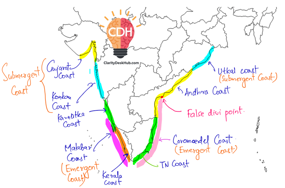
🔹 Regional Names:
- Utkal Coast (Odisha)
- Andhra Coast (Andhra Pradesh)
- Coromandel Coast (Tamil Nadu)
👉 Type of Coastline: Emergent Coastline (land uplifted over time).
The West Coast: The Land of Cliffs and Estuaries
📍 Lies between the Western Ghats and the Arabian Sea.
📍 Extends from the Gulf of Khambhat (Gujarat) to Kanyakumari (Tamil Nadu).
🔹 This coast is narrow, steep, and rugged, formed by short and swift rivers that originate in the Western Ghats.
🔹 Key Features:
- Dotted with estuaries (like those of the Narmada and Tapi rivers).
- Has many natural harbours, making it ideal for ports.
- Kerala backwaters and lagoons (like Vembanad Lake) are unique features.
🔹 Regional Names:
- Konkan Coast (Maharashtra & Goa)
- Karnataka Coast
- Malabar Coast (Kerala)
👉 Type of Coastline:
- Konkan Coast → Submergent Coastline (land has sunk).
- Malabar Coast → Emergent Coastline (land has risen).
Why Do the East and West Coasts Differ?
Think of a tilted wooden plank—if you pour water on it, one side will be submerged, and the other will remain dry. This is exactly what happened during the movement of the Indian Peninsula.
- As India collided with the Eurasian plate, the southern part of the peninsula tilted slightly upwards.
- This resulted in an emergent eastern coast and a mix of emergent + submergent western coast.
Thus, the east coast is flatter and wider, while the west coast is steeper and narrower.
Significance of India’s Coastline
India’s coastline is not just a geographical feature—it is the lifeline of millions of people.
🌾 Agriculture:
- The coastal plains have fertile soils, ideal for rice cultivation.
- Coconut plantations flourish along the shores.
⚓ Ports & Trade:
- Major ports like Mumbai, Chennai, and Kolkata drive India’s economy.
- The deep harbors of the west coast support international trade.
⛏️ Mineral Wealth:
- The Krishna-Godavari Basin (KG Basin) has huge oil and natural gas reserves.
- Kerala’s sands contain Monazite, a key mineral for nuclear energy.
🐟 Fishing Industry:
- Tamil Nadu, Kerala, and Gujarat have thriving marine fisheries.
- Gujarat’s coastal salt pans are famous for salt production.
🛶 Tourism & Natural Beauty:
- Goa’s beaches, Kerala’s backwaters, and Odisha’s Chilika Lake attract tourists.
Final Thoughts
India’s coastline is not static—it is constantly shaped by waves, tides, and human activities. While it provides economic prosperity, it is also vulnerable to rising sea levels, cyclones, and erosion.
Understanding the coastline is not just about geography—it’s about recognizing how nature and human civilization interact. From ancient maritime trade to modern ports and oil reserves, the coastline of India has always been and will continue to be the backbone of the nation’s growth.