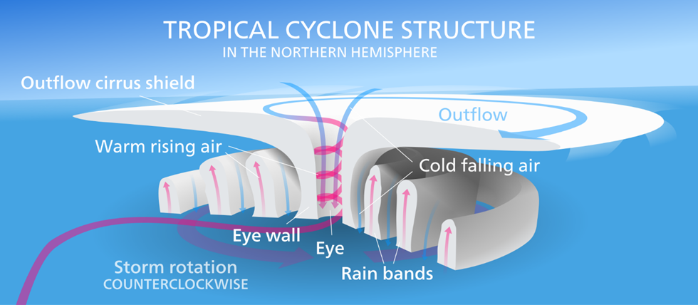
Convective Cyclogenesis
Cyclones are thermal-origin systems, born over warm tropical seas.
They develop through successive stages, each marked by rising wind speeds, increasing organization, and eventually the formation of the eye and eyewall.
Stages of Development of Tropical Cyclone
Stage 1: Tropical Disturbance
- Time: Late summer (Aug–Nov) → oceans are hottest.
- Process: Multiple thunderstorms (local convectional currents) merge.
- Result: Creates a weak low-pressure area called a disturbance.
👉 Think of this stage as the seed of a cyclone — scattered storms beginning to unite.
Stage 2: Tropical Depression
- Due to Coriolis force, winds start spiralling → system begins to whirl.
- Sustained wind speed: < 63 km/h.
- IMD defines maximum sustained wind as the highest 3 minutes of surface wind recorded in the system.
👉 At this stage, the cyclone is still “immature” but now has an identifiable cyclonic circulation
Stage 3: Tropical Storm
- Wind speed: 63–119 km/h.
- Circulation becomes more organised.
- The spiral structure of the cyclone emerges.
- Eye usually not visible yet.
👉 At this point, the cyclone is named by meteorological agencies.
Stage 4: Tropical Cyclone (Mature System)
- Wind speed: > 119 km/h.
- The cyclone acquires its eye → the calm, low-pressure centre.
- Around it forms the eyewall, with the fastest winds and heaviest rainfall.
👉 This is the most destructive stage, and if moisture continues, the system can persist for a week or more.
🌍 Vertical Structure of a Tropical Cyclone
- Inflow Layer (0–3 km): Moist air is sucked in at the base — this drives the storm.
- Middle Layer (3–7 km): Core region of the cyclone — convection and storms dominate.
- Outflow Layer (> 7 km): Air diverges outward, often at 12 km altitude and above. Movement here is anticyclonic.
👉 Inflow at bottom + Outflow at top = continuous engine running on latent heat of condensation.
⚡ Convective Cyclogenesis Mechanism
🌩️ Early Stage
- Warm, moist air rises → cools → condensation occurs.
- Condensation releases latent heat, warming air further → makes it lighter → it rises even more.
- Fresh moist air rushes in → cycle repeats.
- Over warm oceans, this intensifies → winds rush in faster.
- Coriolis force deflects winds → spiralling vortex develops.
👉 This self-sustaining cycle is why cyclones are called “heat engines.”
👁️ Eye Formation
- Inside the vortex, due to centripetal acceleration, winds curve inwards.
- Very strong winds → very strong tangential force → creates a calm central zone = the eye.
- Greater the wind speed → larger the eye.
- Inside the eye:
- Air sinks slowly.
- Heated by adiabatic compression.
- Weather appears calm, sometimes even blue sky is visible.
- Eye size: 8–200 km, mostly 30–60 km.
👉 Around the eye forms the Eyewall = ring of deep convection → strongest winds + heaviest rains.

🌧️ Mature Stage Features
- Cyclone circulation creates rain bands (spiral bands):
- Narrow, long bands spiralling into the centre.
- Made up of cumulonimbus (heavy rainfall), nimbostratus (prolonged rainfall), and cumulus (lighter rain).
- Central Dense Overcast (CDO):
- Thick cirrus shield formed from cloud tops of the eyewall.
- Before cyclone intensifies, the CDO often hides the eye.
👉 Mature cyclones have alternating violent rain bands and calm zones, making their weather highly variable.
