
Earthquakes in India – Risk and impact
Earthquake Zones of India
👉 Seismic Zonation Map
India has released a Seismic Zonation Map under the updated Earthquake Design Code (BIS, 2025). The classification is based on faults, maximum likely events, attenuation, tectonics, lithology, and other geological parameters.
Details of New Zonation
- Number of Zones: Earlier, India was divided into four zones – II, III, IV, and V.
- New Highest-Risk Zone VI: Entire Himalayan arc now falls under Zone VI (earlier split between Zones IV & V).
- Boundary Towns: Settlements lying on zonal boundaries are automatically placed in the higher-risk category.
- Hazard Mapping: Geological conditions are prioritized over administrative boundaries for risk classification.
India’s Earthquake Vulnerability
- Land Area at Risk: 61% of India’s landmass lies in moderate to high hazard zones (earlier 59%).
- Population Exposure: Nearly 75% of India’s population resides in seismically active regions.
Implications of New Map
- Retrofitting: Push for strengthening existing structures in high-risk regions.
- Urban Planning: Halt expansion on soft sediments or near active faults.
- Building Standards: Uniform seismic-resistant codes mandated across Himalayan states.
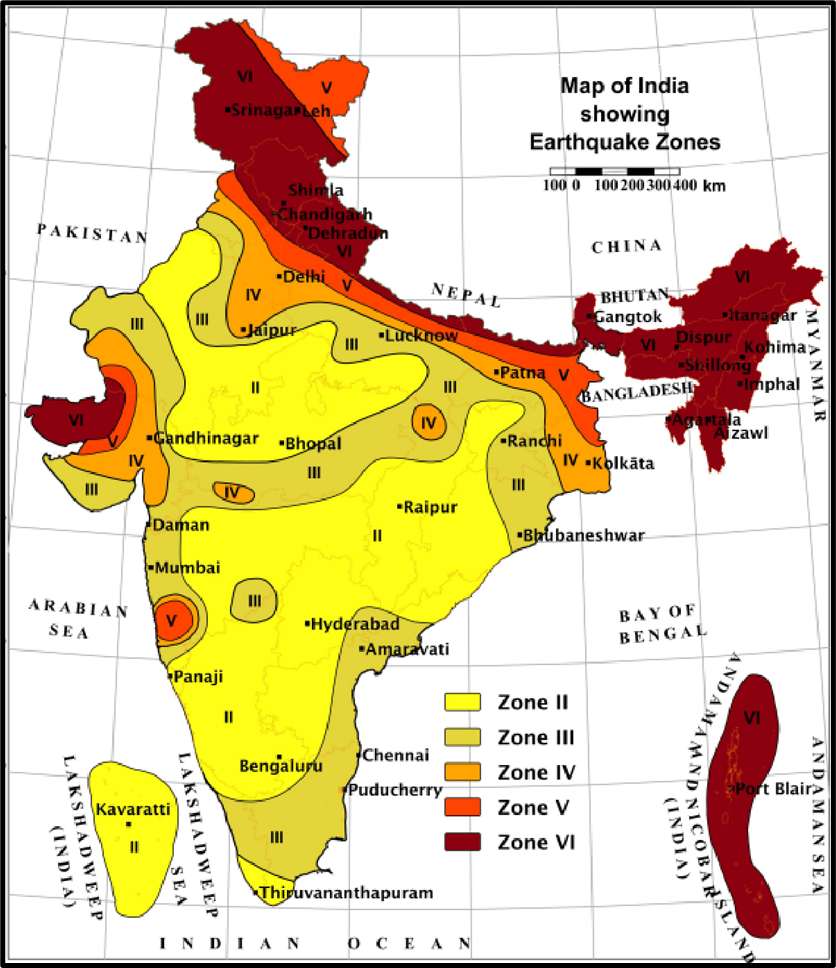
Earthquakes in Delhi–NCR Region
- Delhi falls in Seismic Zone 4, but its location makes it particularly vulnerable.
- It is close to multiple active tectonic faults, such as:
- Mahendragarh–Dehradun Fault (MDF)
- Sohna Fault (SF)
- Mathura Fault (MF)
👉 Seismic Gap – A Silent Danger
- In the Northwest Himalayas, there is a 500 km long Central Himalayan Seismic Gap.
- This area hasn’t experienced a very large earthquake in the past 200–500 years.
- This suggests a significant accumulation of strain/energy, which could release in a major quake.
📌 Definition:
- A Seismic Gap = A fault segment that has not experienced earthquakes for a long time, despite being in an active seismic region.
- It indicates stored strain energy and hence is a potential future epicentre of a big quake.
Earthquakes in the North-East India
- Northeast India is one of the most seismically fragile regions of the world.
- Why so?
- Because of the complex tectonic setting:
- East–West trending Himalayas meet the North–South trending Arakan Yoma belt.
- Several active faults crisscross the region, e.g.:
- Po Chu Fault
- Kopili Fault
- Jiali Fault
- Because of the complex tectonic setting:
The Kopili Fault Zone
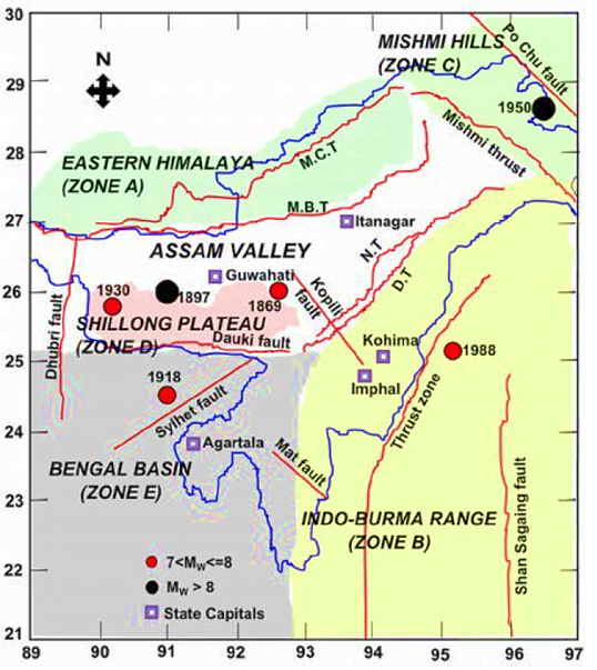
- A major fault zone in Northeast India.
- Characteristics:
- Length: ~300 km
- Width: ~50 km
- Extends from Western Manipur to the tri-junction of Bhutan, Arunachal Pradesh, and Assam.
- It is a tectonic depression, filled with alluvium from the Kopili River (a tributary of Brahmaputra).
👉 Why important?
- The Kopili Fault lies close to the Himalayan Frontal Thrust (Main Frontal Thrust – MFT).
- The Himalayan Thrust Fault marks the boundary between the Indian Plate and Eurasian Plate.
- This is a convergent boundary → Indian Plate is subducting beneath the Eurasian Plate.
- Hence, it falls under Seismic Hazard Zone V (highest risk).
Effects of Earthquakes,
1. Shaking and Ground Rupture
- The primary effect of an earthquake is ground shaking.
- This causes severe damage to rigid structures like:
- Buildings
- Dams
- Bridges
- Nuclear power stations
- Ground rupture = when the fault line literally cracks the ground surface.
- For large engineering structures (e.g., pipelines, metro lines), this is extremely dangerous.
2. Landslides and Avalanches
- Earthquakes destabilize slopes, causing landslides and snow avalanches.
- Particularly common in mountain regions like the Himalayas.
- Earthquakes act together with other hazards—storms, volcanic eruptions, or coastal erosion—to trigger mass movements.
3. Fires
- Earthquakes can rupture electrical lines, gas pipes, and fuel storage tanks.
- This often leads to uncontrollable fires in urban areas.
- Example: 1906 San Francisco Earthquake → more deaths occurred due to fire than due to shaking itself.
4. Soil Liquefaction
- Happens in water-saturated soils.
- During intense shaking, soil particles lose contact with each other → soil behaves like a liquid instead of a solid.
- Effects:
- Buildings and bridges may tilt, sink, or collapse.
- Ground stability is lost, making construction in such areas very risky.
- Example: Observed during the 1964 Niigata Earthquake (Japan).
5. Tsunami
- Caused by Megathrust Earthquakes at subduction zones.
- When the sea floor abruptly moves, it displaces huge volumes of water.
- Generates long-wavelength, long-period sea waves → called tsunami.
- Tsunami can travel thousands of kilometers with devastating impact.
- Example: 2004 Indian Ocean Earthquake and Tsunami.
6. Floods
- Secondary effect of earthquakes.
- Can occur in two ways:
- Damage to dams → sudden water release.
- Landslides block rivers → form temporary lakes → when these collapse, catastrophic floods occur.
- Example: In mountainous areas like the Himalayas, such flood hazards are common after seismic activity.
💡 UPSC Answer-Writing Tip:
Whenever asked about the “impact of earthquakes,” always divide into primary effects (shaking, rupture) and secondary effects (landslides, fires, liquefaction, tsunami, floods). This shows structured thinking.
One Comment