
Formation of the Himalayas
Introduction
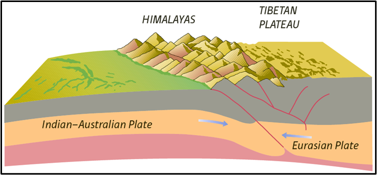
The Himalayas are not just one mountain range; rather, they are a series of parallel and converging ranges formed due to continent–continent convergence (collision of tectonic plates).
👉 Theoretically, the Himalayan system includes:
- The Himalayas proper
- The Purvanchal hills in the northeast
- Their extensions like Arakan Yoma (Myanmar) and even the Andaman & Nicobar Islands.
So, the Himalayas stretch far beyond India — covering India, Nepal, Bhutan, extending into Tibet (Trans-Himalayas), and reaching up to Pakistan, Afghanistan, and Central Asia.
Geological Nature
The Himalayas are:
- Young mountains (geologically speaking, only a few million years old).
- Weak and flexible in structure, which makes them tectonically unstable.
- Continuously affected by internal forces (like faulting, folding, thrusting) and external forces (like river erosion, weathering).
This is why the Himalayas are prone to:
- Earthquakes
- Landslides
- Flash floods
Also, they are cut through by youthful rivers. These rivers create typical young stage landforms:
- Gorges
- V-shaped valleys
- Rapids and waterfalls
Formation of Himalayas Explained
📚 Geological Timeline:
| Time Period | Event |
|---|---|
| ~250 mya | Existence of Pangaea with Laurasia in the north and Gondwanaland in the south |
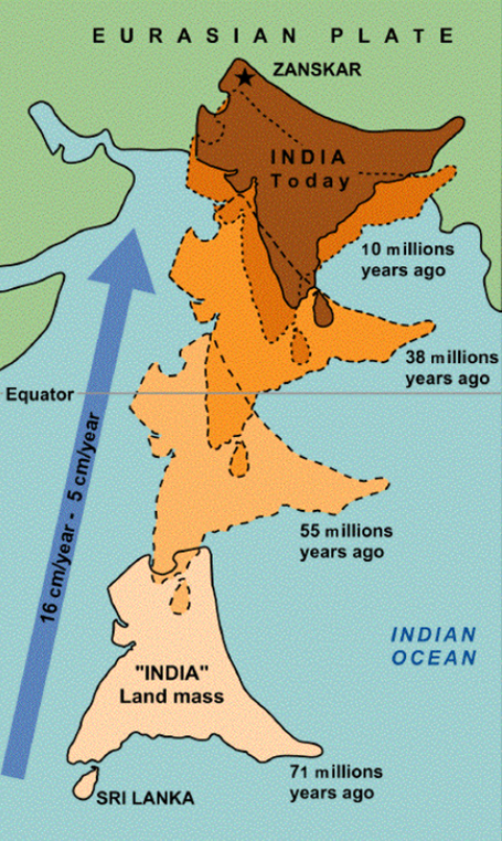
| 200–140 mya | Indian Plate breaks from Gondwanaland, drifts north |
| 60 mya | Deccan Traps erupt (volcanic activity due to mantle plumes) |
| 50–40 mya | India collides with Asia → Initial formation of the Himalayas |
| 30 mya | Major uplift of Greater Himalayas |
| 25–20 mya | Formation of Middle Himalayas |
| 2–20 mya | Formation of Shiwalik Hills (youngest part of Himalayas) |
🧠 Additional Notes:
- India’s speed: Moving northward at ~5–6 cm/year (still ongoing).
- Earthquakes in Himalayan and North Indian regions are proof that orogeny is active.
- Himalayan rivers are rejuvenated and in their youthful stage because uplift is ongoing.
🧭 What is the Suture Zone?
- A suture is where two continental plates have fused.
- It includes remnants of oceanic crust, trapped sediments, and metamorphosed rocks.
- E.g., the Indus–Tsangpo Suture Zone is a crucial marker of the India–Asia collision.
🧬 Tibetan Plateau: The Roof of the World
- Formed due to upthrusting of the Eurasian Plate.
- Today, it’s the highest and largest plateau in the world.
- Evidence like terraced lakes and gravel deposits shows it is still rising.
📈 Evidence of Ongoing Himalayan Uplift
| Evidence | Explanation |
|---|---|
| Satellite measurements | Himalayas rising 5–10 cm/year |
| Lake desiccation in Tibet | Raised lakebeds above current water levels |
| Youthful river profiles | Rejuvenation due to land uplift |
| Frequent earthquakes | Indicates continuing crustal compression |
Formation of the Indo–Gangetic–Brahmaputra Plain
Once the Himalayas rose, new rivers emerged, fed by glaciers.
- These rivers carried huge quantities of alluvium and began depositing it in the depression south of the Himalayas.
- Over time, this depression got filled with alluvium → creating a monotonous aggradational plain (flat land formed by deposition).
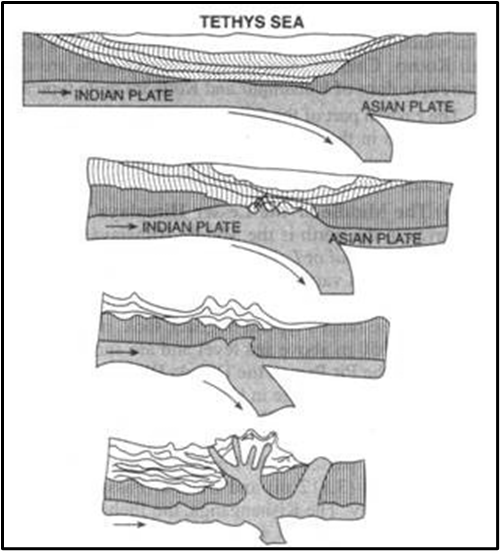
- This marked the disappearance of the Tethys Sea.
Other rivers from the Peninsular Plateau also contributed to this plain, but their role was minor.
👉 In recent geological times, three major river systems — the Indus, the Ganga, and the Brahmaputra — have dominated the deposition.
- That’s why this vast curved plain is called the Indo–Gangetic–Brahmaputra Plain.
✅ In Summary
- The Himalayas = young fold mountains formed due to the collision of Indian Plate and Eurasian Plate.
- Origin lies in Tethys sediments compressed during this collision.
- Himalayas are tectonically unstable, still evolving, and highly dissected by rivers.
- The Indo–Gangetic–Brahmaputra Plain was formed from the deposition of alluvium brought by Himalayan rivers.
Thus, the Himalayas and the plains together represent one of the most spectacular results of plate tectonics in the world.
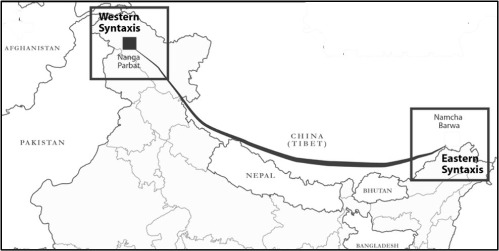
Syntaxial Bend
A Syntaxial Bend refers to the sharp, U-shaped curvature of a mountain range at its ends. In the Himalayas, there are two major syntaxial bends:
- Nanga Parbat Syntaxial Bend (Northwest)
- Namcha Barwa Syntaxial Bend (Northeast)
These bends are the result of intense tectonic compression and rotation during the collision of the Indian and Eurasian plates.
Why is the Eastern Himalayas Higher and Steeper than the Western Himalayas?
- In the Western Himalayas, the uplift occurred step by step, forming a series of gradual elevations.
- In the Eastern Himalayas, the uplift was more abrupt, causing steep and high mountains.
👉 This difference is mainly due to how the Indian Plate collided with the Eurasian Plate:
- First Impact at the Northwest (Nanga Parbat Region)
- The northwestern part of the Indian Plate collided first, creating a hinge-like rotation in an anticlockwise direction.
- Break-Off and Rotation of the Northeastern Part
- After this initial collision, the northeastern edge of the plate (Namcha Barwa region) got hinged, causing further uplift.
- This rotation continued, resulting in a sharp increase in height of the Eastern Himalayas.
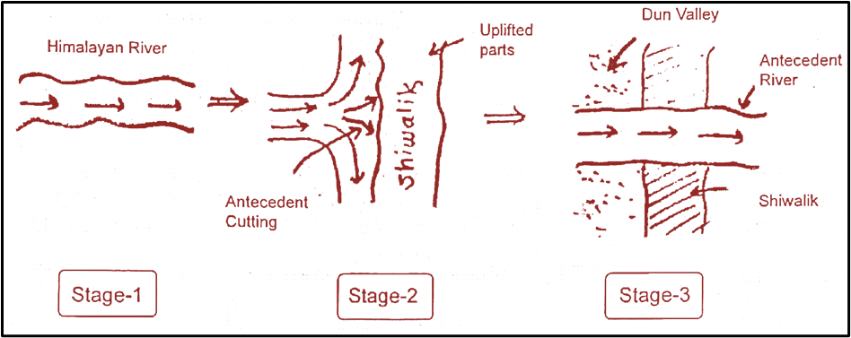
Formation of Dun Valleys
A Dun Valley is a longitudinal valley (i.e., running parallel to the mountain range) located between the Lesser Himalayas (Middle Himalayas) and the Shiwalik Hills (Outer Himalayas). These valleys were formed due to the interaction between rivers and tectonic movements.
Some well-known dun valleys include:
- Dehra Dun (Uttarakhand)
- Patli Dun
- Chumbi Valley (Sikkim-Bhutan-Tibet region)
How Were Dun Valleys Formed?
Step 1: Rise of the Shiwalik Hills
Millions of years ago, the Himalayan region was undergoing intense geological activity due to the collision of the Indian and Eurasian plates. This uplift resulted in the formation of the Shiwalik Hills, the outermost range of the Himalayas.
Step 2: Obstruction of River Flow
Before the Shiwaliks emerged, rivers like the Ganga, Yamuna, and their tributaries were flowing freely from the Lesser Himalayas into the plains. However, as the Shiwalik Hills rose, they blocked these rivers, creating temporary lakes behind them.
Step 3: River Erosion and Formation of Valleys
Over time, these trapped rivers became powerful enough to cut through the Shiwalik Hills, draining the lakes and leaving behind flat valleys, known as Dun Valleys.
👉 Think of it like a dam breaking—once the rivers carved a path through the hills, the stored water rushed out, and a valley was left behind!
Why Are Dun Valleys Important?
- Fertile Land for Agriculture 🌾
- Dun valleys are highly fertile, making them important agricultural zones, especially for crops like rice, wheat, and sugarcane.
- Example: Dehradun is known for its high-quality basmati rice.
- Strategic and Economic Significance 💰
- Some duns, like the Chumbi Valley, lie near international borders, making them strategically important.
- Dun valleys have major cities and settlements, contributing to trade and tourism.
- Rich in Biodiversity 🌿
- These valleys are home to dense forests, supporting wildlife such as elephants, tigers, and deer in national parks like Rajaji National Park near Dehradun.
Significance of the Himalayas for India
When we study the Himalayas, we should not look at them as just a mountain chain. Instead, imagine them as India’s protective wall, water tank, food basket, energy source, and cultural soul—all rolled into one.
1. Climatic Influence – The Wall that Shapes Weather
- The Himalayas act like a giant wall blocking and redirecting winds.
- Monsoon winds: Moisture-laden winds from the Indian Ocean hit the Himalayas, are forced to rise, and as they cool, they drop heavy rainfall. That is why states like Himachal, Uttarakhand, and Assam receive abundant rains.
- Winter winds: The cold, icy winds from Central Asia (similar to the climate of Mongolia/Kazakhstan) are blocked.
- Result: North India is much warmer than Central Asia in winter.
- Without this wall, Delhi or Lucknow would feel more like Siberia!
👉 UPSC take-away: Himalayas = Climate regulator (Rainfall + Temperature control).
2. Defence – India’s Natural Fortress
- Historically, most large-scale invasions from the north were difficult because the Himalayas stood as a natural barrier.
- Even today, for the armed forces, this rugged terrain provides a strategic military advantage.
👉 Remember: While passes (like Khyber, Nathu La, Zoji La) allowed selective invasions/trade, the overall barrier protected India.
3. Source of Rivers – The Water Towers of India
- The Himalayas are the birthplace of major perennial rivers — Indus, Ganga, Yamuna, Brahmaputra.
- Why perennial? Because glaciers act as natural reservoirs, releasing water gradually even in summer.
- These rivers are the lifelines of agriculture, drinking water, and settlements across the plains.
👉 UPSC concept: Glacial-fed rivers vs. Peninsular rain-fed rivers?
4. Fertile Soil – Gift of Alluvium
- Rivers erode soil from the Himalayas and deposit alluvium in the Indo-Gangetic plains.
- Over thousands of years, this has made states like Punjab, UP, Bihar, West Bengal some of the most fertile agricultural zones in the world.
👉 Think of it as the Himalayas constantly “feeding” the plains with fresh soil.
5. Hydroelectricity – Harnessing the Slopes
- The steep gradient and fast-flowing rivers provide ideal sites for hydroelectric dams.
- Examples: Bhakra Nangal (Satluj), Tehri (Bhagirathi/Ganga).
- This ensures renewable energy security for India.
6. Forest Wealth – Biodiversity Hotspot
- The Himalayas host forests ranging from subtropical jungles → temperate conifers → alpine meadows.
- Key resources:
- Timber (pine, deodar).
- Medicinal plants (Himalayan yew, used in anti-cancer drugs).
- Wildlife (snow leopard, red panda).
👉 Part of the Indo-Malayan realm of biodiversity.
7. Agriculture – Unique Crops of the Hills
- Himalayan slopes are used for terrace farming.
- Special crops:
- Tea (Darjeeling tea → global brand).
- Apples (Himachal).
- Saffron (Kashmir).
- These are climate-specific crops not possible in the hot plains.
8. Tourism – Adventure + Serenity
- The Himalayas are India’s tourism magnet.
- Adventure: Skiing (Auli), trekking (Leh–Ladakh), river rafting (Rishikesh).
- Leisure: Shimla, Manali, Nainital, Darjeeling.
- Tourism = major source of income + cultural exchange.
9. Pilgrimage – Sacred Geography
- Himalayas are deeply embedded in Indian spirituality.
- Major pilgrimage centres: Amarnath, Kedarnath, Badrinath, Kailash-Mansarovar, Vaishno Devi.
- These journeys reinforce the Himalayas as the cultural and spiritual heartland of India.
10. Minerals – Resources Beneath the Peaks
- The Himalayas hold deposits of:
- Anthracite coal
- Copper
- Lead
- Zinc
- These contribute to India’s mining and industrial sector.
🎯 Conclusion
So, if you remove the Himalayas from India’s geography, what would happen?
- No barrier for cold winds → India as cold as Central Asia.
- No monsoon rains → Semi-arid like Iran or Afghanistan.
- No rivers and fertile plains → Agricultural collapse.
- No forest wealth, no biodiversity, no hydro-power, no tourism, no pilgrimages.
👉 In short: Without the Himalayas, India wouldn’t be India.
They are not just mountains — they are India’s shield, reservoir, granary, energy hub, biodiversity bank, cultural temple, and spiritual home.