
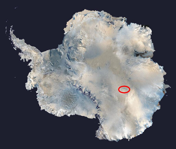
Important Geographical Features of Antarctica
In this section, we move beyond basic facts and dive deep into the major landforms, seas, ice shelves, and oceanic boundaries that define the geography of Antarctica. These features are frequently asked in mapping questions and also hold climatological and geopolitical significance.
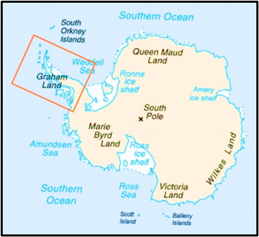
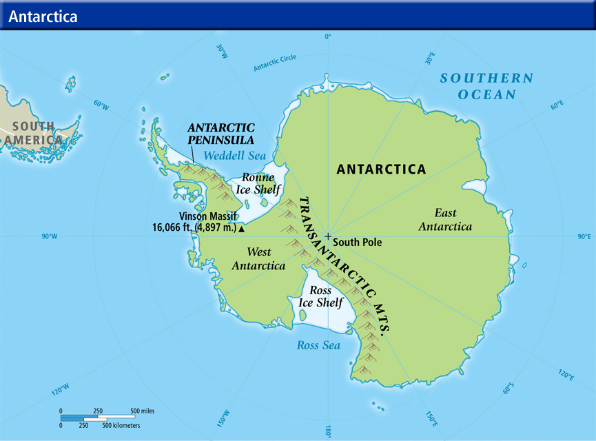
Antarctic Peninsula
- The Antarctic Peninsula is that narrow strip of land that stretches about 1,300 km northwards, pointing toward the southern tip of South America (particularly towards Cape Horn).
- It is ice-covered and mountainous, with rugged terrain.
🗺️ Geopolitical Significance:
- It is claimed by three countries: 🇬🇧 UK, 🇨🇱 Chile, and 🇦🇷 Argentina.
- Because of its closeness to South America, this region becomes a hotspot for territorial claims.
🌊 Bransfield Strait separates this peninsula from the South Shetland Islands—which are a part of British Antarctic Territory.
📍Map Tip for UPSC: Always remember to mark this peninsula bending towards South America, as it helps in orienting Antarctic map-based questions.
Ross Sea
- The Ross Sea is a southern extension of the Southern Ocean — located on the opposite side of the Antarctic Peninsula.
- It creates a large indentation in the otherwise circular outline of Antarctica.
📍 Boundaries:
- West: Cape Adare (in northern Victoria Land)
- East: Cape Colbeck (Edward VII Peninsula)
- North: Near the edge of the continental shelf
🔹 Ross Island:
- A volcanic island in the western Ross Sea, near the Ross Ice Shelf.
- Key Feature: Mount Erebus (3,800 m) — the southernmost active volcano on Earth.
- Also home to Mount Terror and other ranges.
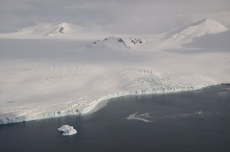
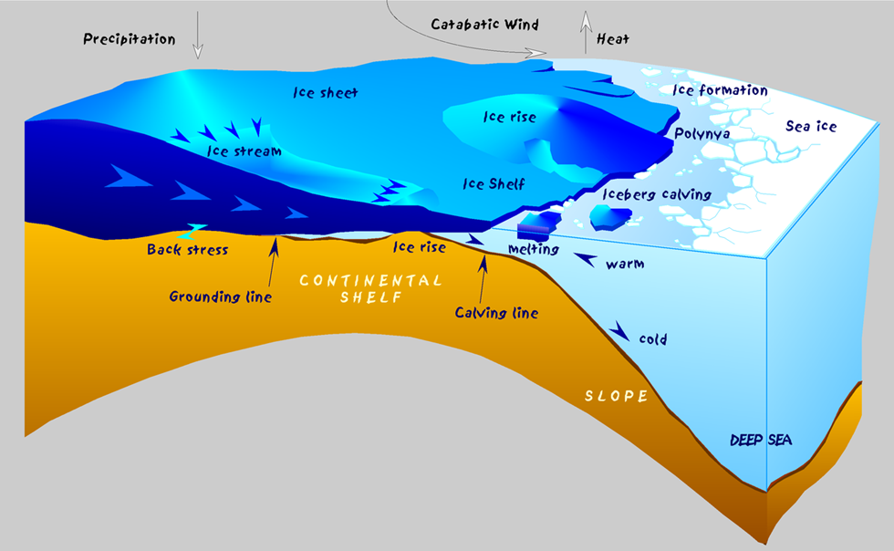
🔹 Ross Ice Shelf:
- World’s largest floating ice body.
- Formed by ice streams and glaciers flowing from East and West Antarctica.
👉 Concept Clarity:
| Term | Definition |
| Ice Sheet | Grounded, massive glacial ice covering land (e.g., East Antarctica) |
| Ice Shelf | Floating extension of an ice sheet over the ocean (e.g., Ross Ice Shelf) |
| Iceberg | A large chunk of ice broken off from glaciers or shelves |
| Sea Ice | Frozen seawater, seasonal, forms and melts annually in polar oceans |
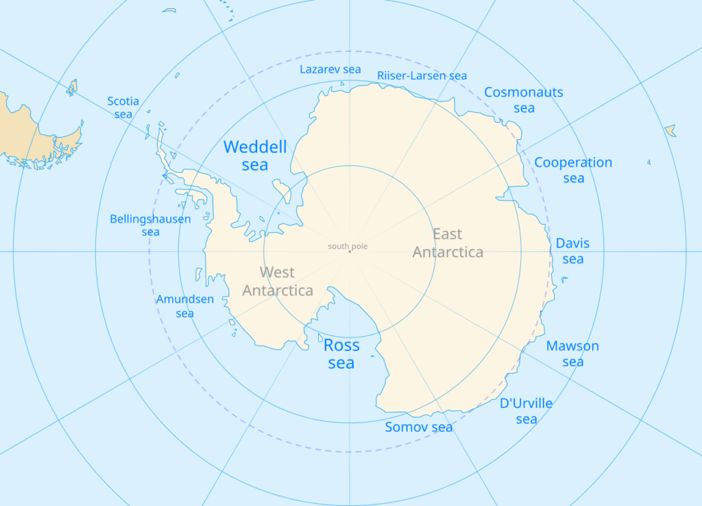
Weddell Sea: The Origin of Cold Bottom Waters
- Located south of the Atlantic Ocean, east of the Antarctic Peninsula.
- It plays a major role in global ocean circulation, particularly in the formation of cold bottom water, which drives the thermohaline circulation.
🔹 Seymour Island is a part of this region, near the peninsula.
🔹 Ice Shelves in Weddell Sea:
- Ronne Ice Shelf – Western portion
- Filchner Ice Shelf – Eastern portion
Both are separated by Berkner Island and together known as the Filchner-Ronne Ice Shelf.
🔹 Larsen Ice Shelf:
- Located on the eastern coast of the Antarctic Peninsula, within the Weddell Sea.
- Divided into Larsen A, Larsen B, and Larsen C.
📉 Disintegration Events (important for climate change):
- Larsen A collapsed in 1995 (~3,250 km² lost).
- Larsen B collapsed in 2002—and disintegrated rapidly in just one month.
- Larsen C lost a massive iceberg in 2017, reducing its size by 12%.
🧠 This illustrates the effect of global warming on polar regions and should be linked with contemporary climate concerns.
Transantarctic Mountains
- One of the longest mountain ranges in the world (~3,200 km).
- It divides East Antarctica and West Antarctica — both physically and geologically.
🔺 Highest Peak: Mount Kirkpatrick (4,528 m)
📍 It runs roughly from the Weddell Sea to the Ross Sea — forming a natural boundary between the two ice sheets.
🌐 Research Significance:
- Several countries like the 🇺🇸 USA, 🇬🇧 UK, and 🇳🇿 New Zealand have set up research stations at its base.
Antarctic Convergence (Antarctic Polar Front)
- This is a natural oceanic boundary — where cold Antarctic water meets and sinks below the warmer Sub-Antarctic water.
🌊 It is not a fixed line, but a dynamic zone—it shifts seasonally and geographically.
🧬 Why is it important?
- It marks a zone of high marine productivity.
- It helps regulate nutrient cycling, supports rich marine ecosystems, and plays a part in thermohaline circulation.
- This boundary keeps Antarctica biologically and thermally isolated.
Drake Passage: The Gateway Between Two Continents
- Located between:
- Cape Horn (southern tip of South America)
- South Shetland Islands (north of the Antarctic Peninsula)
🌊 This is a narrow yet strategic channel connecting the Atlantic and Pacific Oceans.
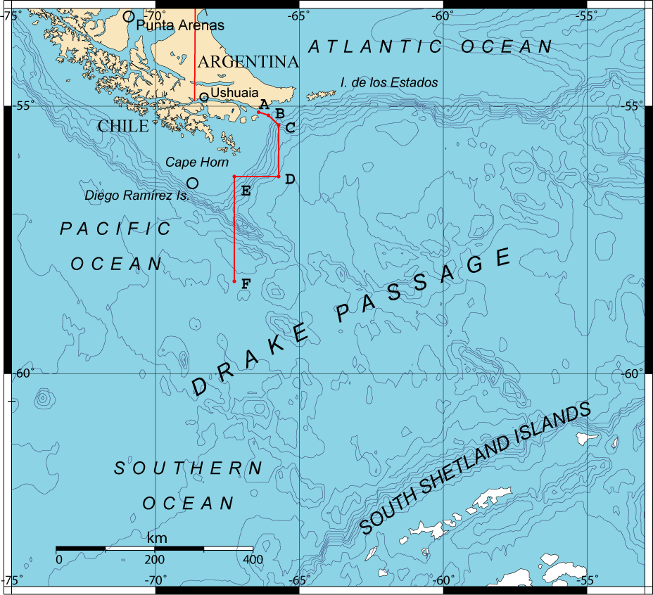
⚡ Characterised by:
- Strong currents
- Rough seas
- Antarctic Circumpolar Current (ACC) — the largest ocean current on Earth, flowing eastward continuously around Antarctica.
📌 The Drake Passage is a major route for:
- Oceanic mixing
- Maritime navigation
- Climatological studies
🧭 Let’s summarise what we have read till now:
| Feature | Type | Significance |
| Antarctic Peninsula | Landform | Geopolitical claims; close to South America |
| Ross Sea & Ice Shelf | Marine + Ice Feature | World’s largest ice shelf; key to ocean-ice interaction |
| Weddell Sea | Sea | Origin of cold bottom water; ice shelf collapse events |
| Transantarctic Mountains | Mountain System | Divides East & West Antarctica |
| Antarctic Convergence | Oceanic Boundary | Thermal and biological boundary |
| Drake Passage | Oceanic Channel | Connects oceans; carries ACC |
Now that we’ve seen the coastal and oceanic geography of Antarctica, let’s turn our attention inward — toward what lies beneath the ice and in ice-free pockets, revealing the hidden and extreme wonders of the continent.
Lake Vostok
- Located underneath Russia’s Vostok Research Station, this is Antarctica’s largest subglacial lake, lying about 4 km below the East Antarctic Ice Sheet.
🧬 Scientific Significance:
- Confirmed in the mid-1990s through seismic and ice-penetrating radar surveys.
- It has remained sealed from the atmosphere for millions of years — making it a potential zone to study ancient microbial life and extreme ecosystems.
Subglacial Lake = A lake trapped beneath a glacier or ice sheet, usually formed due to geothermal heat + pressure from the ice above.
Lake Vostok is the largest of over 400 such lakes identified in Antarctica.
Gamburtsev Mountains: The Ghost Mountains
- A completely buried mountain range in East Antarctica — part of an ancient rift system stretching ~3,000 km.
- Buried under 600+ meters of ice, and discovered using radar surveys.
🗻 Origin:
- Formed around 250 million years ago, likely during the breakup of Gondwana.
- These mountains are comparable in size to the Alps, yet completely hidden — hence often referred to as a “ghost mountain range“.
🔍 Why Important?
- Helps scientists understand the origin and stability of the East Antarctic Ice Sheet — one of the world’s two main ice sheets.
McMurdo Dry Valleys: The Antarctica That Looks Like Mars
- Located on the western coast of McMurdo Sound, these are Antarctica’s largest ice-free region, covering ~4,800 km².
🌪️ Why is it ice-free?
- Extremely low humidity, cold temperatures, and katabatic winds (fast, dry winds descending from high altitudes) that sublimate snow (change snow directly into vapor).
- As a result, it has exposed soil, dry frozen lakes, and no precipitation for nearly 2 million years.
🧪 Scientific Value:
- Due to its harsh, alien conditions, it’s often used by scientists as an analogue for Martian environments.
Blood Falls: Antarctica’s Red Mystery
- Found at the Taylor Glacier, this is a striking red-colored outflow that emerges from fissures in the glacier.
🌋 Why red?
- The color comes from iron-rich, briny water that oxidizes (rusts) upon exposure to air — like iron turning red.
🧬 Scientific Insight:
- The water comes from a subglacial briny lake.
- The high salt content lowers its freezing point, allowing it to flow despite frigid temperatures.
- Also contains unique extremophile microbes living without sunlight, oxygen, or nutrients — relevant for astrobiology.
Important Polar Terms
These terminologies may seem small but are frequently tested — either directly or in comprehension-based MCQs.
| Term | Meaning |
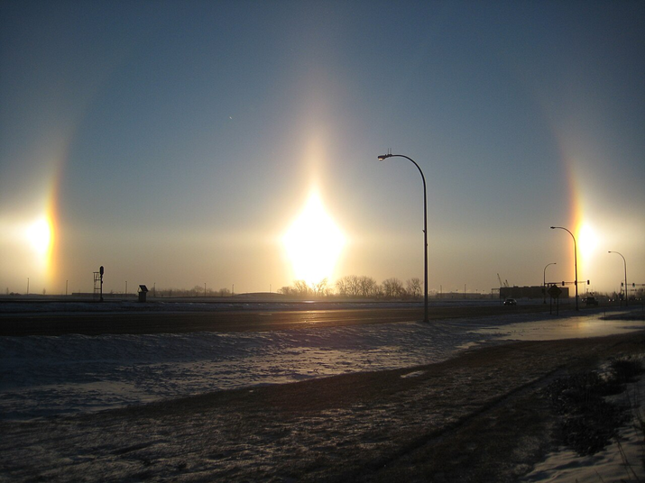
| Diamond Dust | Tiny ice crystals suspended in the air, sparkling like diamonds — often seen in clear, cold Antarctic conditions. Watch |
| Sun Dogs & Halos | Optical phenomena caused by sunlight interacting with ice crystals in the air — appearing as bright spots beside the Sun. |
| Ice Piedmonts | When glaciers spill out onto flat coastal plains, forming broad ice masses. Common along Antarctica’s coastline. |
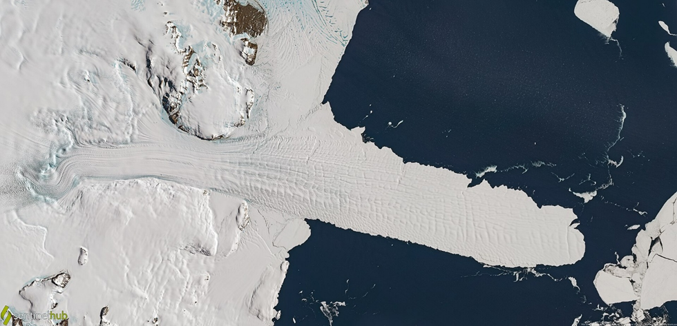
| Ice Tongues | Long, narrow glacier extensions that float into the ocean. Example: Drygalski Ice Tongue. |
| Polynyas | Open areas of sea water surrounded by sea ice — serve as breeding and feeding grounds for marine animals. |
🧠 Polynyas are particularly important for Antarctic marine life — like penguins and seals — and are influenced by ocean currents and wind patterns.
📌 Quick Recap Table
| Feature | Type | Unique Point |
| Lake Vostok | Subglacial lake | 4 km under ice; isolated microbial life |
| Gamburtsev Mountains | Subglacial mountains | Hidden Alps-like range; vital for ice sheet formation studies |
| McMurdo Dry Valleys | Ice-free valley region | Mars-like terrain; lowest precipitation on Earth |
| Blood Falls | Glacial outflow | Red water from briny subglacial lake, rich in iron & microbes |
2 Comments