
Influencing factors of Indian Monsoon
Indian Monsoons – Role of Tropical Easterly Jet (TEJ)
What is TEJ?
- TEJ stands for Tropical Easterly Jet—a band of high-speed winds in the upper troposphere (around 6–9 km above sea level).
- Found between 5° and 20°N latitude, stretching from Peninsular India to Northern Africa.
- It is persistent from June to early October—i.e., during the northern hemisphere summer.
The Backstory – How TEJ Forms
- In summer, the Tibetan Plateau heats up abnormally (due to its high elevation and strong solar radiation).
- This massive heating changes the pressure and temperature patterns in the upper atmosphere.
- Scientists don’t fully understand every detail, but they agree this heating plays a key role in creating the TEJ.
Connection with Other Winds
- In the tropics, the low-level jets (LLJs)—like the Somali Jet and African Easterly Jet—are important for moisture transport.
- TEJ is different—it’s an upper-level wind system, moving east to west (opposite to the west-to-east flow of mid-latitude jet streams).
TEJ and the Monsoon Onset
- Before TEJ appears, the Subtropical Jet Stream (STJ) sits south of the Himalayas, blocking monsoon flow.
- In early June, STJ shifts north of the Himalayas, clearing the path for TEJ to emerge.
- Once TEJ establishes itself, it reverses the upper air circulation pattern—high-pressure areas aloft become low-pressure zones.
- This reversal acts like a green signal for the south-west monsoon to advance rapidly over India.
How TEJ Aids the Monsoon
- TEJ descends over the Indian Ocean near Madagascar, strengthening a high-pressure cell there.
- This intensified high pressure pushes moist winds from the ocean toward the Indian subcontinent—fueling the south-west monsoon.
💡 Memory Tip:
“STJ moves away → TEJ takes over → Upper air switches to low pressure → Monsoon gets the green signal.”
Indian Monsoons – Role of the Tibetan Plateau
The Tibetan Plateau is not just a geographical feature—it’s like a giant air-conditioner in winter and a massive heater in summer, controlling the very rhythm of the monsoon.
The Tibetan Plateau – Two Roles
- Mechanical Barrier: Its huge height (average >4,000 m) blocks and redirects atmospheric circulation.
- Heat Source (in summer): Heats up faster than surrounding areas—2–3°C warmer—creating strong low-pressure zones above it.
Summer: Heating and the Monsoon Cell
- Heating over Tibet creates an intense low-pressure cell due to rising warm air (convergence).
- This air moves upward, diverges in the upper troposphere, and then descends (subsides) over the equatorial Indian Ocean—this is part of the monsoon cell.
- The subsiding air flows back toward India as equatorial westerlies, carrying moisture from the Indian Ocean.
- These moisture-laden winds hit India’s west coast, causing monsoon rainfall.
Winter: Cooling and N-E Monsoon
- Tibet cools rapidly, creating a high-pressure cell (anticyclonic condition).
- This strengthens the North-East Monsoon, which affects southern India and Sri Lanka.
Link with the Tropical Easterly Jet (TEJ)
- The longer and stronger the summer heating over Tibet, the stronger and longer-lasting the TEJ—leading to heavier monsoon rainfall in India.
- If snow over Tibet doesn’t melt properly, TEJ fails to develop → weak monsoon.
- Therefore, heavy snow in winter → weak monsoon next year (important UPSC point).
Link with the Subtropical Jet Stream (STJ)
- The summer heating pushes the STJ northward beyond the Himalayas (around 40°N by early June), clearing the path for monsoon winds.
- By mid-October, as Tibet cools, STJ shifts south again, marking the withdrawal of the monsoon.
💡 UPSC Quick Hook:
- Summer Tibet = Heat Source → Low Pressure → TEJ Strong → Monsoon Strong
- Winter Tibet = Cold Source → High Pressure → N-E Monsoon Strong
- Heavy Snow = Weak Next Monsoon
Indian Monsoons – Role of the Somali Jet
Think of the Somali Jet as the express delivery partner for the South-West Monsoon—it helps push monsoon winds toward India faster and stronger.
What is the Somali Jet?
- A low-level jet stream in the lower troposphere, active during the northern hemisphere summer.
- Travels across Kenya, Somalia, and the Sahel, before reaching the Arabian Sea.
- Originates near Mauritius and northern Madagascar, then curves toward Kenya (around 3°S).
Role in Monsoon Onset
- Strengthens the permanent high-pressure area near Madagascar.
- This intensified high acts like a pump, driving moist south-westerly winds from the Arabian Sea toward India.
- The result: faster and more intense monsoon onset.
The Findlater Current
- Ocean current in the Arabian Sea associated with the Somali Jet.
- Direction changes with the monsoon winds—reverses during seasonal transitions.
- During SW Monsoon, it causes coastal upwelling near the Horn of Africa.
- Benefit: Increases nutrient content in surface waters → boosts fish catch.
- Limitation: This upwelling zone is small, so it doesn’t significantly influence Indian monsoon rainfall (unlike the Indian Ocean Dipole).
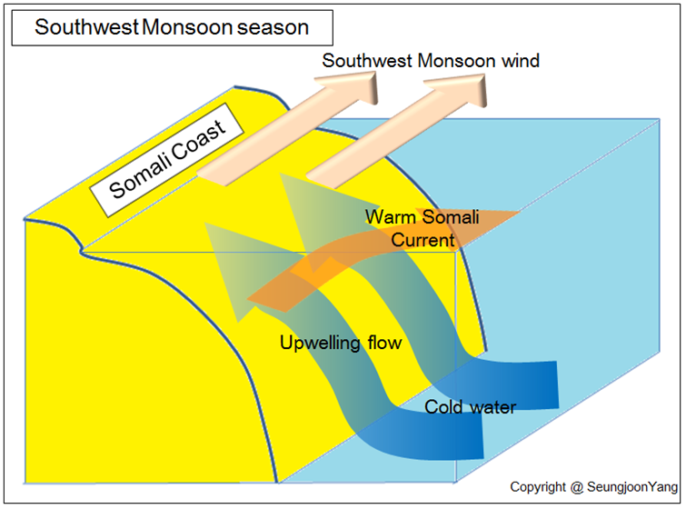
By Seung Joon Yang, CC BY-SA 3.0, via Wikimedia Commons
💡 UPSC Memory Hook:
Somali Jet = Arabian Sea Accelerator → Strengthens Madagascar High → Pushes SW Monsoon toward India
Findlater Current = Somali Jet’s ocean partner → Reverses direction with monsoon → Local upwelling near Horn of Africa
Impact of El Niño on Indian Monsoon
- El Niño is an abnormal warming of sea surface temperatures in the eastern equatorial Pacific Ocean.
- It weakens the trade winds, disrupting normal monsoon patterns.
Illustration of Indian Monsoon during normal conditions:
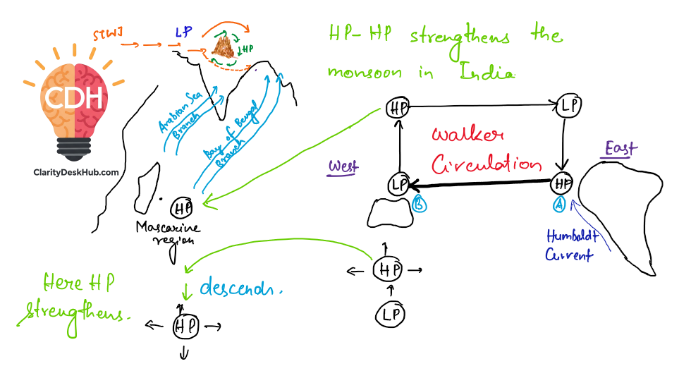
Illustration of Indian Monsoon during El-Nino:
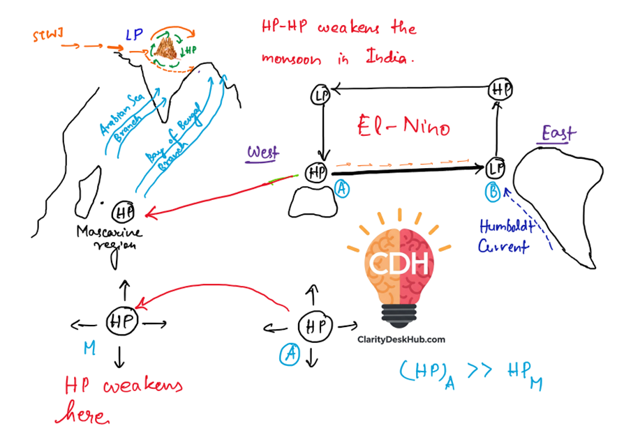
Impact on Indian Monsoon:
- Causes deficient rainfall and drought-like conditions in India.
- Weakens the southwesterly monsoon winds, leading to a weaker monsoon season.
- Delayed onset and uneven distribution of rainfall.
- Affects agriculture, water availability, and economy.
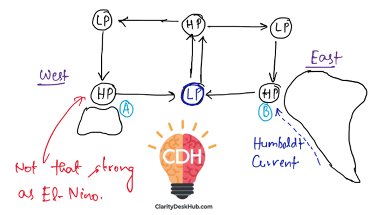
What is El Niño Modoki?
- Unlike conventional El Niño, El Niño Modoki involves warming in the central tropical Pacific, while the eastern and western Pacific remain cooler.
- This results in two separate Walker Circulation cells, with a wet region in the central Pacific and dry conditions in the east and west.
- Its impact on the Indian monsoon is variable, sometimes weakening the monsoon, but not always as severely as conventional El Niño.
Conclusion:
El Niño negatively impacts the Indian monsoon by reducing rainfall, leading to droughts and agricultural losses. However, factors like the Indian Ocean Dipole (IOD) and El Niño Modoki can moderate or amplify its effects. Understanding these patterns is crucial for better monsoon forecasting.
Impact of La Niña on the Indian Monsoon
What is La Niña?
La Niña is the counterpart of El Niño and represents a cooling phase of the El Niño-Southern Oscillation (ENSO). It occurs when trade winds strengthen, pushing warm surface waters westward and allowing cold, deep ocean waters to upwell in the central and eastern Pacific. This results in colder-than-normal sea surface temperatures in the tropical Pacific.
How Does La Niña Affect the Indian Monsoon?
La Niña typically enhances the Indian monsoon by strengthening trade winds and increasing moisture transport.
Effects on India and Beyond:
- Stronger and wetter Indian Monsoon: La Niña leads to above-normal rainfall in India, reducing the risk of drought and benefiting agriculture.
- Higher agricultural output: Favorable monsoons boost crop yields, improving food production and rural income.
- Increased flood risk: Excessive rainfall may lead to floods, particularly in states like Bihar, Assam, and Uttar Pradesh.
- Colder winters in northern India: The phenomenon contributes to harsher winters due to intensified western disturbances.
- Cyclone formation in the Bay of Bengal: More cyclonic storms occur during La Niña years, impacting eastern coastal regions.
Global Effects of La Niña:
- Southeast Asia & Australia: Abnormally heavy rains, leading to floods.
- Southeastern Africa: Cooler and wetter conditions.
- Northwestern U.S. & Canada: Colder and snowier winters.
- Southern U.S.: Drought conditions prevail during winter.
Conclusion
For India, La Niña is generally beneficial as it strengthens monsoonal rainfall, supporting agriculture and water availability. However, it also brings risks of excessive flooding and harsher winters, requiring careful management of water resources and disaster preparedness.
Pacific Decadal Oscillation (PDO)
What is PDO?
The Pacific Decadal Oscillation (PDO) is a long-term fluctuation in sea surface temperatures between the northern/western tropical Pacific and the eastern tropical Pacific Ocean. Unlike El Niño or La Niña, which operate on shorter time scales (3–7 years), the PDO shifts occur roughly every 20 to 30 years.
Phases of PDO:
There are two phases of the PDO:
- Negative (Cool) Phase:
- Western/Northern Pacific waters become relatively warmer.
- Eastern Pacific waters become colder.
- Positive (Warm) Phase:
- Western/Northern Pacific waters become relatively colder.
- Eastern Pacific waters become warmer.
How Does PDO Impact Climate?
- The PDO influences jet streams and storm tracks across North America.
- It can amplify or weaken El Niño and La Niña events.
- Positive PDO often aligns with El Niño, strengthening its effects.
- Negative PDO is linked to La Niña, enhancing its cooling impact.
Effect on Indian Monsoon:
- A Positive PDO (associated with El Niño) weakens the Indian monsoon, leading to drought-like conditions.
- A Negative PDO (linked to La Niña) strengthens the monsoon, bringing above-normal rainfall.
Conclusion:
Although the exact causes of PDO remain unclear, its influence on global weather patterns, including monsoons and El Niño events, makes it a crucial factor in long-term climate variability. Understanding PDO helps in predicting monsoon strength and managing agricultural planning in India.
Indian Ocean Dipole (IOD)
What is IOD?
The Indian Ocean Dipole (IOD) is a climate phenomenon characterized by periodic oscillations in sea surface temperatures across the western and eastern Indian Ocean. It moves through three phases:
- Positive IOD
- Neutral IOD
- Negative IOD
How Does IOD Work?
- Positive IOD:
- The western Indian Ocean warms up (temperature rises above normal by 0.4°C).
- The eastern Indian Ocean (near Indonesia and Australia) cools down due to the weakening of equatorial westerly winds.
- This strengthens the Indian monsoon as southwesterly winds are redirected toward the Indian subcontinent.
- However, it causes droughts in Indonesia and Australia.
- Negative IOD:
- The eastern Indian Ocean warms up, while the western Indian Ocean cools down due to strong equatorial westerly winds.
- This can weaken the Indian monsoon, leading to lower rainfall in India.
- Australia and Indonesia receive excess rainfall.
Illustration of Positive IOD
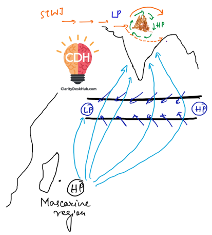
Look at the figure and note that:
- Sometimes, due to certain climatic conditions, the equatorial westerlies weaken.
- When this happens, trade winds dominate the region instead.
- Normally, 70% of monsoon winds move towards India, while 30% are diverted towards Southeast Asia.
- During a Positive IOD, a high-pressure (HP) system forms near Indonesia/Southeast Asia.
- This HP system redirects the winds from Southeast Asia towards India, strengthening the Indian monsoon.
- The HP-LP (High Pressure – Low Pressure) pattern formed during Positive IOD is weaker than that of El Niño.
- It is also weaker than the normal monsoonal HP-LP system, but still contributes to enhancing the monsoon.
Illustration of Negative IOD:
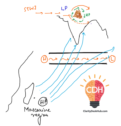
- Unlike Positive IOD, here the equatorial westerlies become stronger, which impacts the monsoon wind flow.
- A Low-Pressure (LP) system develops over Southeast Asia (Indonesia & nearby regions).
- This attracts more monsoonal winds towards Southeast Asia, diverting them away from India.
- With more monsoonal winds moving towards Southeast Asia, India receives only about 50-60% of its usual monsoon winds.
- This results in weaker monsoon rains over India.
- While the Indian monsoon weakens during a Negative IOD, it does not necessarily lead to drought like El Niño.
- This is because the HP-LP system during Negative IOD is much weaker than during El Niño, meaning the monsoon is reduced but not completely suppressed.
Impact on Indian Monsoon:
- A positive IOD can counteract El Niño, ensuring a strong monsoon even if El Niño is present.
- A negative IOD can weaken the monsoon, leading to below-normal rainfall in India.
Conclusion:
The IOD plays a crucial role in modulating the Southwest Monsoon, sometimes offsetting the adverse effects of El Niño. Understanding IOD helps in improving monsoon predictions and planning for droughts or floods in the Indian subcontinent.
Summary:
| Topic | Key Points | Impact on Monsoon |
|---|---|---|
| Tropical Easterly Jet (TEJ) | • Upper-troposphere winds (6–9 km) between 5°–20°N, from Peninsular India to N. Africa. • Active June–Oct. • Forms due to intense summer heating over Tibetan Plateau. • East-to-west flow, unlike mid-latitude westerly jets. | • STJ moves north in June → TEJ emerges. • Reverses upper-air pressure (HP → LP), signalling SW monsoon onset. • Descends near Madagascar → strengthens HP → drives moist winds to India. |
| Tibetan Plateau | • Acts as mechanical barrier + heat source in summer. • Summer: 2–3°C warmer than surroundings → intense LP above → monsoon cell formation. • Winter: Strong HP → NE monsoon. | • Summer heating → TEJ stronger & lasts longer → heavier rainfall. • Heavy snow in winter delays melting → weak TEJ → weak monsoon. • STJ pushed north in summer; returns south in Oct → monsoon withdrawal. |
| Somali Jet | • Low-level jet in lower troposphere, June–Sept. • Originates near Madagascar/Mauritius → curves to Kenya → Arabian Sea. | • Strengthens Madagascar HP → pumps moist SW winds to India → rapid monsoon onset. |
| El Niño | • Warming of E. equatorial Pacific SSTs → weak trade winds. | • Weak SW monsoon winds → delayed onset, uneven rain, drought risk. |
| El Niño Modoki | • Central Pacific warming, east & west cooler → 2 Walker cells. | • Variable monsoon impact; weaker than classic El Niño. |
| La Niña | • Cooling of E. & central Pacific SSTs; strong trade winds. | • Stronger SW monsoon → above-normal rainfall; risk of floods. • Colder winters in N. India; more Bay cyclones. |
| Pacific Decadal Oscillation (PDO) | • 20–30 yr SST cycle in N. Pacific. • Positive phase = E. Pacific warm, W/N Pacific cool. • Negative = Opposite. | • Positive PDO + El Niño = weak monsoon. • Negative PDO + La Niña = strong monsoon. |
| Indian Ocean Dipole (IOD) | • SST difference between W. & E. Indian Ocean. Positive IOD: West warm, East cool → stronger monsoon. Negative IOD: East warm, West cool → weaker monsoon. | • Positive IOD can offset El Niño. • Negative IOD diverts winds to SE Asia → weaker rainfall in India. |