Thunderstorms
General Characteristics
Imagine a hot summer afternoon. The ground is burning, the air feels heavy, and suddenly you see tall, black clouds building up in the sky. Within a short while, rain pours down furiously, thunder roars, and lightning flashes. This is what we call a thunderstorm.
Technically, a thunderstorm is a local storm that develops quickly, with:
- Strong upward movement of air (called updraft),
- Heavy rainfall,
- Thunder and lightning,
- And clouds that are large, dense, and towering cumulonimbus.
🌩️ According to A.N. Strahler, a thunderstorm is “an intense local storm associated with large cumulonimbus clouds in which there are very strong updrafts of air.”
Because of the sudden heavy downpour, thunderstorms are often called “cloudbursts”, though the rain doesn’t last long.
👉 How are they different from cyclones?
- A cyclone is a large, circular system where winds blow from outside towards the center in a spiral.
- A thunderstorm, on the other hand, is localized and defined mainly by vertical uplift of air.
Thus, thunderstorms are a special case of the convective mechanism—that is, heating of the surface makes air rise vigorously.
Structure of a Thunderstorm
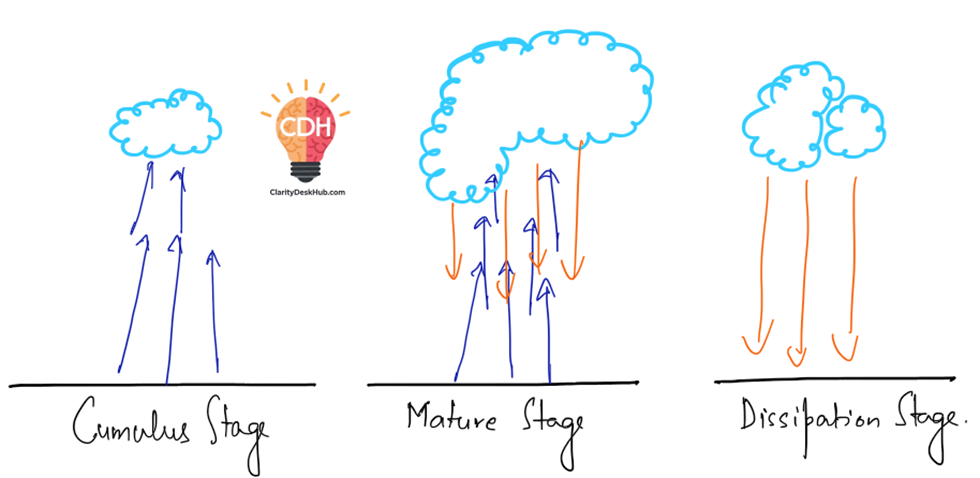
A thunderstorm is not just a single block of cloud—it consists of several convective cells. Each of these cells goes through a life cycle of three stages:
- Cumulus Stage (Youth)
- Warm air rises strongly upward.
- Clouds form rapidly due to condensation.
- Only updrafts dominate at this stage.
- Mature Stage
- Both updrafts and downdrafts (descending air currents) are present.
- Rainfall begins; thunder and lightning are at their peak.
- This is the most intense stage.
- Dissipating (Senile) Stage
- Downward-moving winds dominate and spread across the surface.
- Vertical uplift stops.
- Clouds spread into umbrella-shaped layers like altostratus or cirrostratus.
- The storm weakens and dies out.
👉 Important point: In a single thunderstorm, different cells may be at different stages simultaneously. That is why thunderstorms can feel like they revive and die multiple times during their course.

Conditions for Thunderstorm Development
Now the question is—why do thunderstorms develop?
They need certain atmospheric conditions:
- Atmospheric Instability
- If the atmosphere is unstable, rising air will continue to rise instead of sinking back.
- Instability occurs when the normal lapse rate (rate at which temperature decreases with height) is greater than the adiabatic lapse rate (rate of cooling of rising air).
(Guys, understand this intuitively: See, the environment is getting colder quickly with height. The rising parcel, cooling more slowly, remains warmer than its surroundings and therefore, it is buoyant and continues to rise and hence instability)
- Warm and Moist Air (Fuel of Thunderstorms)
- An abundant supply of warm, moist air is essential.
- This is why thunderstorms are common in summer afternoons or tropical regions.
- Surface Heating (Insolation)
- Intense heating of the ground makes air lighter and unstable.
- This rising air triggers convection and thunderstorm formation.
- Orographic Lift
- When warm, moist winds hit mountains (orographic barriers), they are forced to rise, cool, and form thunderstorms.
- Cloud Thickness and Icing Level
- Between the cloud base (where condensation begins) and the icing level (where water droplets turn into ice), the greater the thickness, the stronger the thunderstorm.
- In tropical regions, the icing level is high, giving clouds more vertical thickness—hence frequent thunderstorms.
- In middle latitudes, icing level is relatively low, so thunderstorms are less intense.
✅ In summary:
- Thunderstorms are short-lived but powerful local storms caused by rapid upward movement of warm, moist air.
- They have a 3-stage life cycle—cumulus, mature, and dissipating.
- Their intensity depends on atmospheric instability, moisture, heating, and cloud thickness.
- That’s why they are more common in low latitudes (tropics) than in middle latitudes.
Thunderstorms and Weather
Thunderstorms are not just about rain and lightning. They influence the weather around them in several dramatic ways. Let’s try to understand this:
Rainfall
- Rainfall in a thunderstorm is different from tropical cyclones.
- In a cyclone, rainfall may last for several days.
- But in a thunderstorm, rainfall is intensely heavy yet of short duration.
👉 Why is it short but intense? Two reasons:
- Rapid upward rise of air: Air is forced to rise abruptly with great force → leads to quick condensation → clouds form rapidly → torrential rainfall.
- Abundant absolute humidity: During summer, high temperature causes rapid evaporation → air becomes moisture-laden → when it rises, massive rainfall occurs.
- Within a thunderstorm, rainfall depends on its convective cells:
- Maximum rainfall at the centre of each cell.
- Minimum at the periphery.
- A strong (fully developed) cell rains for about one hour, while a weak cell may die out within a few minutes.
Hailstorms
- Sometimes rainfall turns into hail.
- This happens when condensation occurs below freezing point, leading to ice pellets formation.
- Hail size may vary—from tiny peas to large balls.
- Hail is not universal:
- Not all thunderstorms produce hail.
- Even within one thunderstorm, only certain cells generate hail.
- When do hails fall?
- While convection currents are strong, they keep the ice particles suspended.
- When currents weaken, hail suddenly drops to the surface.
👉 Impact: Severe damage to crops, livestock, property, and even human life.
Lightning
- In a mature thunderstorm, strong electrical activity develops inside clouds.
- Charge separation occurs:
- Positive charges accumulate in the upper portion of the cloud.
- Negative charges concentrate in the lower portion.
- Discharge values may reach 20–30 coulombs.
- When the electrical potential gradient (difference between charges) becomes steep, a discharge occurs → lightning.
⚡ Alternative theory:
- Large water drops contain both positive and negative charges.
- Normally, charges are balanced.
- But when drops split, the balance is disturbed → difference between positive and negative charges → lightning.
We will discuss more about Lightning later in this section.
Thunder
- Lightning produces immense heat, up to 10,000°C.
- This heat causes sudden expansion of the air column around the lightning channel.
- The air vibrates violently, creating a shock wave → heard as the thundering sound.
- This deafening noise is also called cloud thunder.
Squall
- After a thunderstorm matures and heavy precipitation occurs, something dramatic happens:
- Cold air descends rapidly towards the ground.
- On reaching the surface, it spreads out with great force.
- This sudden downward and outward movement is called a squall.
👉 Key features:
- Wind speed can equal or even exceed hurricane velocity.
- Squalls often cause large-scale damage to buildings, trees, and crops.
✅ In summary:
- Thunderstorm weather is marked by short but intense rainfall, often localized.
- Hailstorms occur when condensation takes place below freezing point.
- Lightning is the electrical discharge caused by charge separation within clouds.
- Thunder is simply the sound of rapidly expanding heated air.
- Squalls are violent surface winds created by descending cold air after heavy rain.
Classification of Thunderstorms
Thunderstorms don’t all form in the same way. Their mode of origin and the lifting mechanism of air determine their type. Broadly, they are classified into two categories:
- Air Mass Thunderstorms
- (i) Heat (Thermal or Local) Thunderstorms
- (ii) Orographic Thunderstorms
- (iii) Advectional Thunderstorms
- Frontal Thunderstorms
- (i) Warm Front Thunderstorms
- (ii) Cold Front Thunderstorms
Let us understand each type step by step.
1. Air Mass Thunderstorms
These form within an air mass itself, due to internal instability and lifting of moist air.
(i) Heat (Thermal or Local) Thunderstorms
- Cause: Intense heating of the ground (insolation) → strong thermal convection currents.
- Nature:
- Localized; limited area.
- Most common in summer afternoons; usually disappear by evening.
- Known as the “real” thunderstorms because they display classic features: sudden development, heavy rain, thunder, and quick dissipation.
- Favorable regions:
- Tropical doldrums (near equator): high temperature + abundant moisture + wind convergence.
- Interiors of continents in middle latitudes during summer.
- Strength factors:
- If the ground is very warm, storm becomes stronger.
- If it moves over water bodies (lakes, rivers, reservoirs), it weakens — since there’s no strong heat supply from below.
⚡ Note: Difficult to predict due to highly uncertain, variable behavior.
(ii) Orographic Thunderstorms
- Cause: When warm, moist, unstable air strikes a mountain barrier, it is forced to rise rapidly along the slope.
- Process:
- Rising air condenses → latent heat released → accelerates uplift → extremely strong thunderstorm develops.
- Produces torrential rainfall, often called cloudburst rain.
- Example:
- Cherrapunji (Meghalaya): Orographic lifting of southwest monsoon winds against Khasi Hills produces >12,000 mm annual rainfall — one of the world’s heaviest.
- Nature:
- More widespread and longer lasting than heat thunderstorms.
- Easier to forecast, since they are linked to geography (mountain barriers).
(iii) Advectional Thunderstorms
- Cause: Form when the normal lapse rate increases abnormally, making the atmosphere unstable.
- Typical process:
- A cold layer of air lies beneath a warm layer.
- During overcast nights, upper cloud layers lose heat through radiation → become cool and dense → sink downward.
- This forces the underlying warm, lighter air to rise rapidly → convection → thunderstorm.
- Key feature: These often develop at night, especially under a cloudy sky.
2. Frontal Thunderstorms
These occur along weather fronts, where contrasting air masses meet.
(i) Warm Front Thunderstorms
- Cause: Develop when humid sea breezes rise slowly along a warm front.
- Nature:
- Very weak.
- Cumulus clouds don’t form because uplift is gentle.
- Not considered significant for weather hazards.
(ii) Cold Front Thunderstorms
- Cause: Develop when cold, dense air advances and undercuts warm, moist air, lifting it abruptly.
- Nature:
- Much stronger than warm-front type.
- Associated with temperate cyclones, hence easier to predict.
- Can occur any time of day or year (not dependent on ground heating).
✅ In summary:
- Heat thunderstorms: Local, afternoon summer storms — real thunderstorms.
- Orographic thunderstorms: Mountain-induced, most active — cause extreme rainfall (e.g., Cherrapunji).
- Advectional thunderstorms: Night-time storms due to cooling of upper cloud layers.
- Warm-front thunderstorms: Weak, insignificant.
- Cold-front thunderstorms: Strong, associated with temperate cyclones, predictable.
Supercell Thunderstorms
What makes them special?
- Among all thunderstorms, supercells are the most powerful and destructive.
- They usually develop in temperate regions, especially along frontal boundaries (where warm and cold air masses meet).
The role of Wind Shear
The key factor here is strong wind shear.
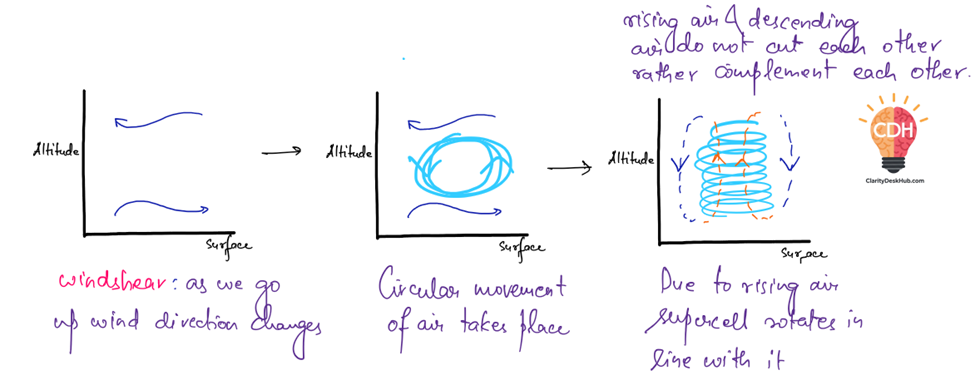
- Wind shear means: wind speed and direction change with altitude.
- Example: At the surface, wind might blow from the south at 20 kmph, but a few kilometers above, it may blow from the west at 100 kmph.
- This difference creates a rotating motion in the rising air currents.
The Spiraling Updraft
- In ordinary thunderstorms, air rises vertically.
- But in supercells, because of wind shear, the updraft rotates in a spiraling motion.
- This rotating updraft is called a mesocyclone — the heart of a supercell.
👉 As this rotating updraft rises, it feeds into the cumulonimbus cloud from the center.
The Downdraft Placement
- Heavy rainfall creates downdrafts (descending air).
- In normal storms, downdrafts often interfere with updrafts, cutting off the storm’s fuel.
- But in a supercell:
- The spiraling updraft occupies the central zone.
- The downdrafts shift towards the edges/corners.
👉 This separation means updraft and downdraft don’t cancel each other. Instead, they complement each other, allowing the storm to sustain and intensify.
Why so destructive?
- Because the storm structure allows continuous fuel supply (warm moist updraft) without being choked by downdrafts, a supercell can last for several hours.
- Supercells are responsible for:
- Giant hailstorms
- Torrential rainfall
- Damaging winds
- And sometimes even tornadoes
✅ In summary:
A Supercell Thunderstorm forms in temperate regions along fronts due to strong wind shear.
This creates a rotating spiraling updraft (mesocyclone) that feeds cumulonimbus clouds.
Since downdrafts are pushed to the corners, both airflows coexist and reinforce the storm → making it long-lasting, intense, and destructive.

Lightning
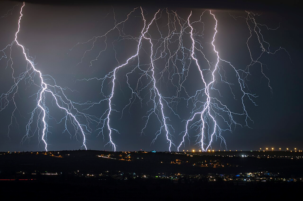
Imagine standing under a stormy sky, watching dark clouds roll in. Suddenly, a blinding streak of light flashes across the sky, followed by a deafening roar of thunder. This awe-inspiring natural spectacle is lightning, one of the most powerful forces of nature.
But what exactly is happening up there in the clouds? How does this massive discharge of electricity occur, and why does it sometimes strike the Earth? Let’s embark on a journey into the heart of a thunderstorm to uncover the science behind lightning 😊
What is Lightning?
Lightning is a massive electrical discharge that occurs in the atmosphere. It happens when an enormous difference in electrical charge builds up between different layers of a cloud—or between a cloud and the Earth’s surface. When this charge imbalance becomes too great, nature seeks to restore balance, releasing energy in the form of a powerful electric spark—lightning.
Think of it as a cosmic-scale short circuit, where nature’s electrical wiring is at play between the sky and the ground.
How Does Lightning Form?
To understand lightning, we need to look inside the storm clouds—specifically, towering cumulonimbus clouds that stretch 10-12 km into the sky.
Step 1: The Birth of Charges
☁️ A storm cloud is like a giant battery in the sky.
🌡️ Warm, moist air rises, carrying water vapor upward.
❄️ As temperatures drop, water condenses into tiny droplets and later freezes into ice crystals.
Step 2: The Charge Separation
⚖️ Inside the cloud, a complex dance of particles takes place:
- Lighter ice crystals rise to the top.
- Heavier ice particles and hailstones fall to the bottom.
- As these collide, electrons are stripped away, creating a negative charge in the middle of the cloud and a positive charge at the top.
This creates an electrical potential difference—similar to what happens when you rub a balloon on your hair, but on a much larger scale!
Step 3: The Discharge (Lightning Strike)
⚡ When the charge imbalance becomes extreme—in the range of a billion to 10 billion volts—the electricity seeks to discharge. It jumps across the air gap, creating a lightning bolt!
🔹 Sometimes this happens within the cloud (intra-cloud lightning).
🔹 Other times, it strikes between clouds (cloud-to-cloud lightning).
🔹 The most dramatic case: cloud-to-ground lightning, where the negative charge in the cloud seeks the positive charge on Earth’s surface.

How Does Lightning Reach the Earth?
🌍 The Earth is a good conductor of electricity but is normally neutral. However, compared to the negatively charged middle of the storm cloud, the ground becomes positively charged.
⚡ About 15-20% of all lightning discharges reach the Earth’s surface.
🏢 Tall structures like trees, buildings, and towers attract lightning more because they act as shortcuts for the electric charge.
When lightning reaches 80-100 meters above the ground, it changes course to find the shortest, most conductive path—often striking trees, poles, or people caught in the open.
What Happens When Lightning Strikes?
The sheer power of lightning is mind-boggling:
🔥 Temperatures reach 30,000°C—five times hotter than the surface of the Sun!
💨 The intense heat instantly vaporizes moisture, causing rapid expansion of air.
🔊 This expansion creates shock waves, producing thunder—the sound of lightning!
Lightning Records: Nature’s Megaflashes
According to World Meteorological organisation:
⚡ Longest Lightning Bolt – 829 km (USA, 2017)
⏳ Longest Duration Flash – 17.10 seconds (Uruguay and Northern Argentina, 2020)
These extraordinary events, called “Megaflashes”, occur when electrical discharges travel across vast distances inside storm clouds.
Lightning Strikes in India
⚠️ Lightning is the deadliest natural disaster in India, causing more deaths than floods or cyclones.
☠️ Uttar Pradesh and Bihar have the highest lightning-related fatalities.
📈 The number of lightning days in India is increasing, possibly due to climate change.
Can We Predict and Prevent Lightning Strikes?
🛰️ Modern satellite technology can track storm clouds and warn about potential lightning strikes.
🏠 Lightning rods on buildings provide a safe path for electrical discharge.
⛔ Safety Tips:
- Avoid open fields and tall trees during storms.
- Stay inside a closed vehicle (cars act as Faraday cages).
- Do not use mobile phones outdoors during a storm.
Conclusion
Lightning is both a breathtaking spectacle and a deadly force. While it plays a crucial role in balancing Earth’s electrical charge, it also poses serious risks to life and property.

One Comment